| 1671a. | [1671]: MONTANUS, Arnold state 1 NOVI BELGII, / Quod nunc NOVI JORCK, vocatur, / NOVÆq ANGLIÆ & Partis / Virginiæ / Accuratissima et Novissima / Delineatio. [5e]From: Montanus De Nieuwe En Onbekende Weereld … America …, Amsterdam, 1671From: John Ogilby America …, London, 1671From: Olfert Dapper Die Unbekante Neue Welt, Oder … America …, Amsterdam, 1673 | 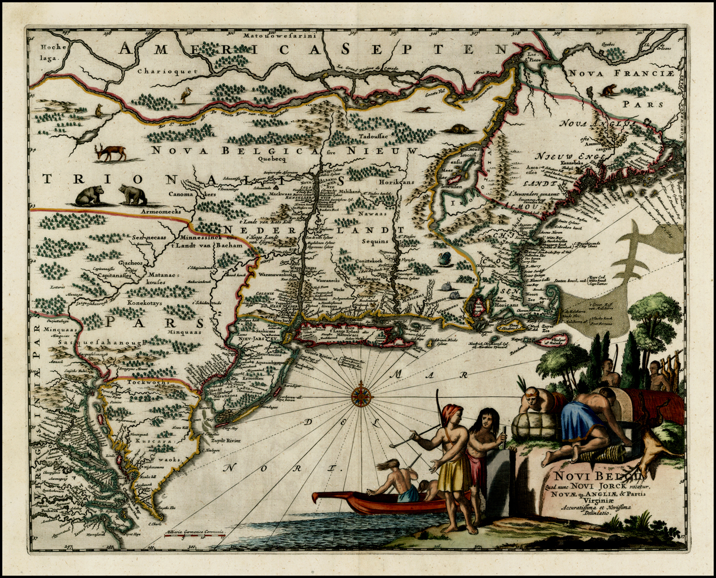 Copper engraving, 290 x 360mm.McCorkle: New England, 671.1 (ill); Campbell: Jansson-Visscher Sequence, 21. |
| 1671b. | [1671] – [1729]: MONTANUS, Arnold state 2 NOUVELLE / HOLLANDE, / (a present / NOUVELLE-YORK) / NOUVELLE-ANGLETERRE, / et une partie de la / VIRGINIE, / dresses sur les propres manuscrits de ceux qui ‘en ont / fait la decouverte, et mises en lumiere par / PIERRE VANDER AA, / Marchand Libraire A LEIDE. [5d]From: Pieter van der Aa La Galerie Agreable Du Monde …, Leiden, [1729] | State 2: with the title completely re-engraved, now showing Europeans trading with natives. Within the map, the animals have been erased. A number of names have been added, including ‘CANADA’ [4b] ‘Philadelphie’ [4d, on the shore of Delaware Bay !] and ‘PENSILVANIE’ [4d] McCorkle: New England, 729.1; Campbell: Jansson-Visscher Sequence, 22. |
| 1671c. | [1671] – [ca. 1735]: MONTANUS, Arnold state 3 NOUVELLE / HOLLANDE, / (a present / NOUVELLE-YORK) / NOUVELLE-ANGLETERRE, / et une partie de la / VIRGINIE, / dresses sur les propres manuscrits de ceux qui ‘en ont / fait la decouverte, et mises en lumiere par / Covens & Mortier. [5d]From: Johannes Covens & Cornelis Mortier Atlas Nouveau …, Amsterdam, [ca. 1735] | State 3: with the imprint of Covens and Mortier substituted.Not in McCorkle: New England, but cf. 729.1; Campbell, Jansson-Visscher Sequence, 22a. |
| 1672a. | [1672]: BLOME, Richard state 1 A Draught of the / Sea Coast and Rivers, / of Virginia, Maryland, / and New England. / Taken from the latest / Surveys, / London Printed for / Ric. Blome. [3d] To y.e R.t Hon: Cæcilius Calvert Baron Balte= / more de Baltemore Absolute L.d & Proprietary / of y.e Provinces of Maryland & Avalon, &c. / This Mapp is Humbly Dedicated by R: Blome. [1c] [Arms with motto] ‘Fatti Maschij Parole Femine.’From: Blome A Description Of The Island Of Jamaica …, London, 1672Inset: ‘A Draught of the Isle of Newfondland.’ 89 x 90 [5e] | Copper engraving, 200 x 253mm.McCorkle: New England, 672.1 (ill). |
| 1672b. | [1672] – [1678]: BLOME, Richard state 2 A Draught of the / Sea Coast and Rivers, / of Virginia, Maryland, / and New England. / Taken from the latest / Surveys, / London Printed for / Ric. Blome. [3d] To y.e R.t Hon: Cæcilius Calvert Baron Balte= / more de Baltemore Absolute L.d & Proprietary / of y.e Provinces of Maryland & Avalon, &c. / This Mapp is Humbly Dedicated by R: Blome. [1c] [Arms with motto] ‘Fatti Maschij Parole Femine.’From: Blome A Description Of The Island Of Jamaica …, London, 1678 | 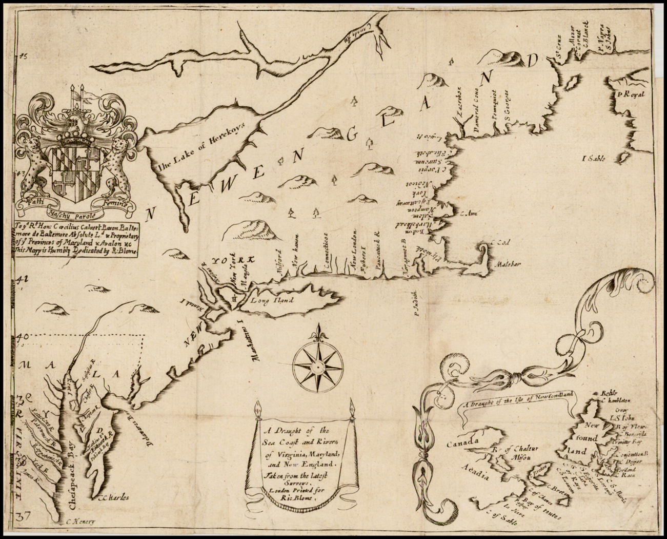 Copper engraving, 202 x 251 PM: 206 x -mm.State 2: the border between Virginia and New England has been crudely erased, and moved further north; the latitude numerals in the lower left hand border have been re-engraved, with 40 [degrees] moved further north. The river flowing into the north end of the Cheapeake has been extended above the Virginia / New England boundary, and the ‘James R.’ crudely erased and moved southwards.Not in McCorkle: New England, but cf. 672.1. |
| 1673a. | [1673 ca.]: DANCKERTS, Justus state 1 NOVI BELGII / NOVAEQUE ANGLIAE NEC NON / PARTIS / VIRGINIAE TABVLA / multis in locis emendata. a Iusto Danckers. [4d]Justus Danckerts Separate publication, Amsterdam, [ca. 1673 ?]Insets: ‘NIEUW AMSTERDAM / op t’Eylant Manhattans’ [2e-4e]’Modus muniendi apud Mahikanensis / Maniere van Woorplaetsen ofte Doorpen der Mahicans / ende andre Natien haer geburen. [1b][Untitled circular Indian village] [1c] | McCorkle: New England, 680.2; Campbell: Jansson-Visscher Sequence, 8; Deak, pl.41.Location: NN, Stokes Collection; |
| 1673b. | [1673 ca.] – [ca.1685]: DANCKERTS, Justus state 2 NOVI BELGII / NOVAEQUE ANGLIAE NEC NON / PENNSYLVANIAE, ET PARTIS / VIRGINIAE TABVLA / multis in locis emendata, a / Iusto Danckers. [4d]Justus Danckerts Separate publication, Amsterdam, [ca. 1685]Inset: ‘NIEUW YORCK, / eertys Genaemt / NIEUW AMSTERDAM / op’t Eyland Manhattans. [2e-4e] | 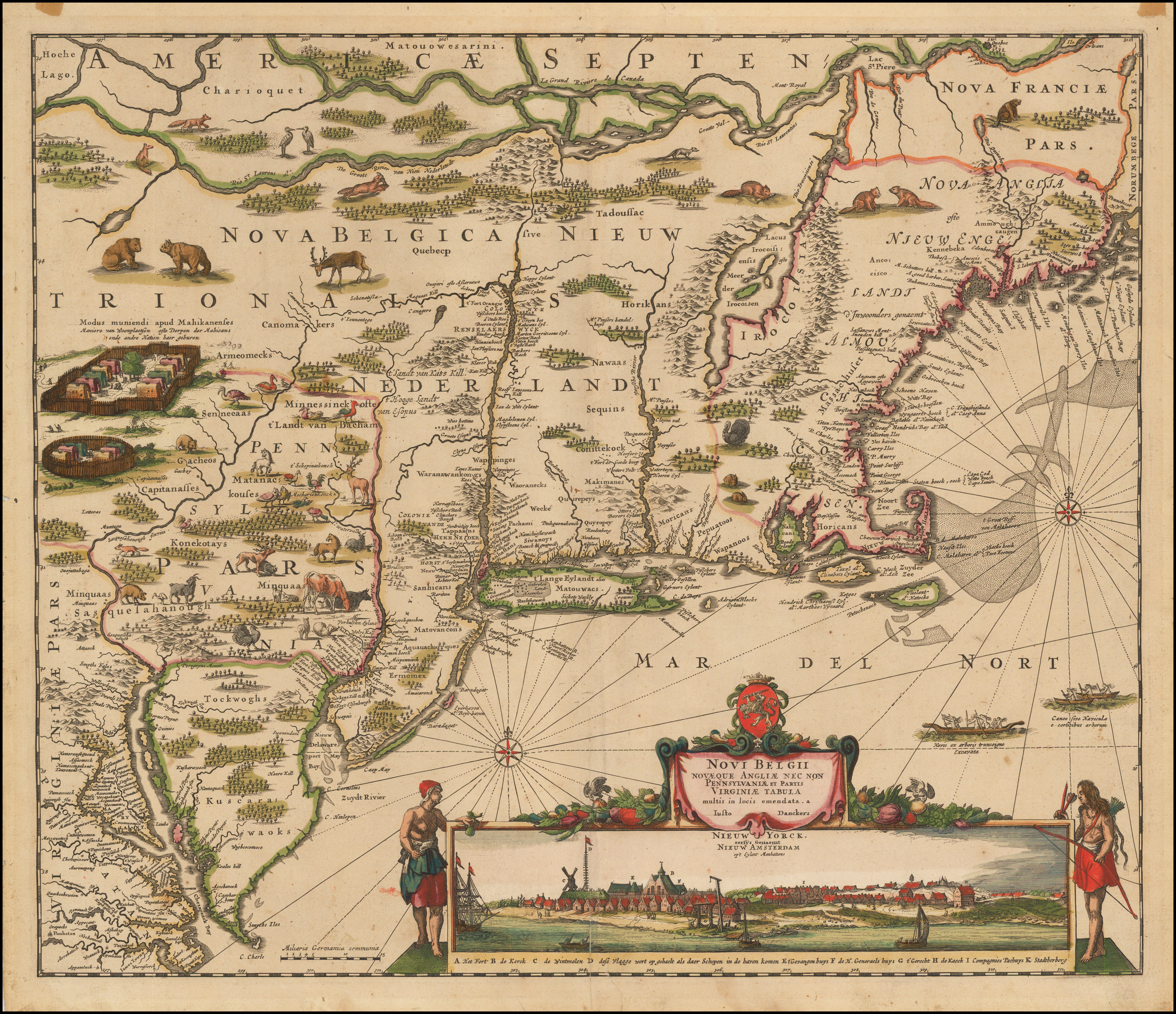 State 2: with the title re-engraved. Within the map the course of the Delaware River has been redrawn, so it is no longer in two branches, and now runs parallel to the Hudson River. ‘Delaware / Bay’ is added [2d], and ‘Philadelphia’ named [2d]. ‘MA / RY / LANT’, ‘NEU IARSEY’ and ‘PENN= / SYL= / VA / NIA’ are named, with their boundaries inserted [2d]. Graduations have been added to the scale bar.Campbell: Jansson-Visscher Sequence, 9 (pl.150 & 151); Skelton: Decorative Printed Maps, pl.73. |
| 1673c. | [1673 ca.] – [ca.1685]: DANCKERTS, Justus state 3 NOVI BELGII / NOVAEQUE ANGLIAE NEC NON / PENNSYLVANIAE ET PARTIS / VIRGINIAE TABVLA / multis in locis emendata, a / Iusto Danckers. [4d]Justus Danckerts Separate publication, Amsterdam, [ca. 1685] | state 3: a small number of further additions have been made within the map, including: ‘Nieuw Castel alias Sandhoeck’ (on the west shore of the Delaware river) and ‘Yermonton’ (above Philadelphia).Campbell: Jansson-Visscher Sequence, 9a (Robert Douwma, Catalogue 16, item 160) |
| 1674. | [1674]: [JUSTEL, Henri] Costes Et Rivieres / de VIRGINIE, / de MARILAND / et de / NOUVELLE / ANGLETERRE. [3d] R. Michault Scrip. [4e] From: [Justel] Receuil De Divers Voyages Faits En Afrique Et En L’Amerique …, Paris, 1674Inset: ‘L’ISLE DE TERRE NEVVE.’ [4d; 4d/e – 5d/e] | 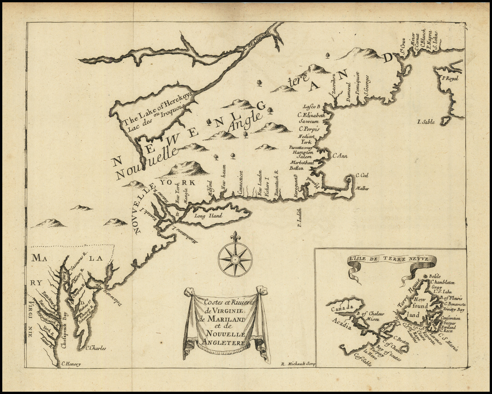 McCorkle: New England, 674.1. |
| 1675. | [1675]: [SPEED, John] NEW ENGLAND / and / NEW YORK. [4d]From: Speed A Prospect Of The Most Famous Parts Of The World … [Pocket Edition], London, 1675 | 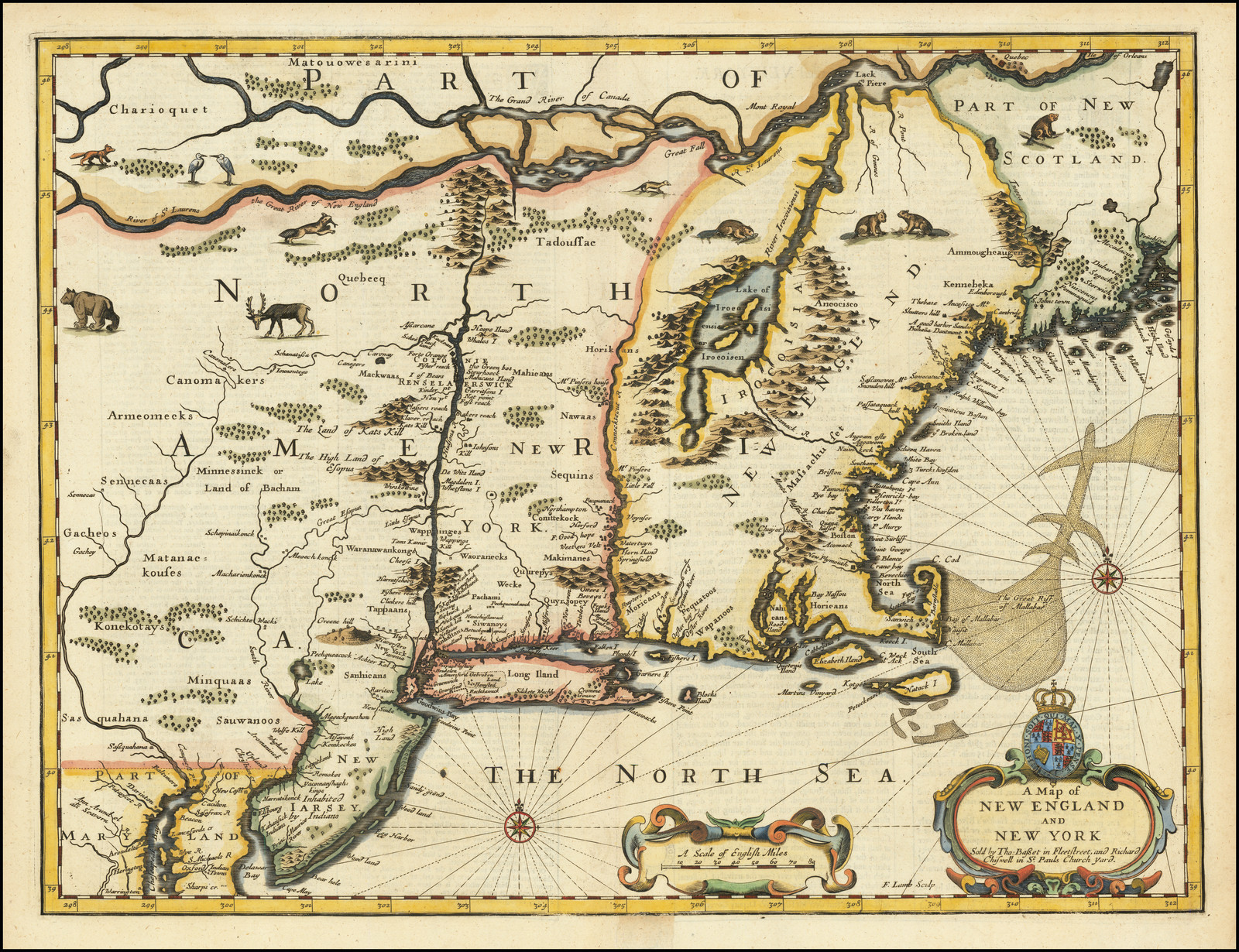 Copper engraving, 84 x 125 PM: 87 x 129mm.McCorkle: New England, 675.8 (ill). |
| 1676:01a | [1676]: MORDEN, Robert & BERRY, William A Map of / New ENGLAND / New YORKE New IERSEY / MARY-LAND & VIRGINIA / Sould by Robert Morden at y.e Atlas in / Corn-hill neer y.e Royal Exchange and by / William Berry at y.e Globe between York / House & y.e New Exchange in y.e Strande / London. [5d] Gr. King sculpsit. [2e]Morden & Berry Separate publication, advertised in The London Gazette, for February 14th-17th 1676 | Copper engraving, 445 x 524mm.McCorkle: New England 676.3 (ill); Black: Blathwayt Atlas, Map 10 & 11; |
| 1676:02a | [1676]: SELLER, John Sr. state 1 A Mapp / of / New ENGLAND / by / John Seller Hydrographer / To the King / And are to bee Sold at his / Shop at the Hermitage in Wappin.g / And by Iohn Hills / In Exchange Alley in Cornhill / London. [2a]John Seller Sr. Separate publication, London, [1676], advertised in The London Gazette, April 10th-13th 1676[Royal Arms] [3b] [Blank dedicatory cartouche] [2b]Inset: ‘The manner of the Indian Fortifications / Towns Houses and Dwelling / places. [1b] | Copper engraving, 433 x 543mm.McCorkle: New England, 676.5 (ill); |
| 1676:02b | [1676]: SELLER, John Sr. state 2 A Mapp / of / New ENGLAND / by / John Seller Hydrographer / To the King / And are to bee Sold at his / Shop at the Hermitage in Wappin.g / And by Iohn Hills / In Exchange Alley in Cornhill / London. [2a] Ornat.mo Prudent.moq Domino / ROBERTO THOMSON / Armigero / Hanc Novæ Angliæ Tabulam / D.D.D. Johannes Seller. [2b] [surmounted by his Coats of Arms]John Seller Sr. Separate publication, London, [1676], | State 2: with the addition of the dedication [2b]; the scale has been moved to the right, and increased in length to 80 miles. A graticule has been added. Within the map, soundings have been inserted near New York [1d], a hill, marsh, and tree symbols in Connecticut [2d] and around the Royal Arms [3b]. A deer and two egret have been inserted on the Connecticut coast [2d]. Long Island has been extended to the south-west [2e].McCorkle: New England, 676.5 (notes); Goss: Mapping Of North America, 42 (col. ill). |
| 1676:02c | [1676]: SELLER, John Sr. state 3 A Mapp / of / New ENGLAND / by / John Seller Hydrographer / To the King / And are to bee Sold at his / Shop at the Hermitage in Wappin.g / And by Iohn Hills / In Exchange Alley in Cornhill / London. [2a] Ornat.mo Prudent.moq Domino / ROBERTO THOMSON / Armigero / Hanc Novæ Angliæ Tabulam / D.D.D. Johannes Seller. [2b] [surmounted by his Coats of Arms]John Seller Sr. Separate publication, London, [1676] | State 3: with more trees added around the Royal Arms, for example to the west of the Blue Hills [3b].McCorkle: New England, 676.5 (notes). |
| 1676:03 | [1676]: [SPEED, John] A Map of / NEW ENGLAND / AND / NEW YORK / Sold by Tho: Bassett in Fleetstreet, and Richard / Chiswell in S.t Pauls Churchyard. [4e] F. Lamb Sculp. [4e]From: Speed A Prospect Of The Most Famous Parts Of The World … [Folio Edition], London, 1675 | Copper engraving, 378 x 502 PM: 385 x 507mm.McCorkle: New England, 676.6 (ill); Campbell: Jansson-Visscher Sequence, 23 (pl.XVI & XIX: detail of Cape Cod); Johnson: America Explored, p.128-9(ill). |
| 1677:01a | [1677] FOSTER, John THE WHITE HILLS MAP state 1 A MAP OF / NEW ENGLAND, Being the first that ever was here cut, and done by / the best Pattern that could be had, which being in / some places defective, it made the other less exact: / yet doth it sufficiently shew the Scituation of / the Country, and conveniently well the / distance of Places. / The figures that are joyned with the Names of Place / are to distinguish such as have been assaulted / by the Indians from others. / [rule] / [scale bar]. [5a]From: William Hubbard A Narrative Of The Troubles With The Indians In New England … John Foster, Boston, 1677 | Woodcut with handcut lettering, 300 x 382mm.McCorkle: New England, 677.2;Wheat & Brun, 144; Black: Blathwayt Atlas, II, p.171; Schwartz & Ehrenberg, pl.68; Johnson: America Explored, p.107 (ill); Bagrow, p.251 (ill). |
| 1677:01b | [1677] – [1677] FOSTER, John THE WHITE HILLS MAP state 2 A MAP OF / NEW ENGLAND, Being the first that ever was here cut, and done by / the best Pattern that could be had, which being in / some places defective, it made the other less exact: / yet doth it sufficiently shew the Scituation of / the Country, and conveniently well the / distance of Places. / The figures that are joyned with the Names of Place / are to distinguish such as have been assaulted / by the Indians from others. / [rule] / [scale bar]. [5a]From: William Hubbard A Narrative Of The Troubles With The Indians In New England … John Foster, Boston, 1677 | State 2: a town symbol has been added between ‘Seaconk’ and ‘Plimouth’ [2c].McCorkle: New England, 677.2 (ill), but not noting the two states; Wheat & Brun, 145; Streeter Sale, II, 640 (ill); |
| 1677:02 | [1677] FOSTER, John THE WINE HILLS MAP A MAP OF / NEW-ENGLAND, / Being the first that ever was here cut, and done / by the best Pattern that could be had, which being / in some places defective, it made the other less / exact: yet doth it sufficiently shew the Scitua- / tion of the Countrey, and conveniently well / the distance of Places. / The figures that are joyned with the Names of / Places are to distinguish such as have been as- / saulted by the Indians from others. / [rule] / [scale bar]. [5a]From: William Hubbard The Present State Of New England. Being A Narrative Of The Troubles With The Indians In New England …, London, 1677 | Woodcut, with handcut lettering, 296 x 388mm.That this map, the so-called ‘Wine Hills’ map belongs to the English edition is established by the type lettering used with, for example, the italic ‘w’ in the title also found in the text (demonstrated by Woodward).This map is copied from the Boston edition, even to the extent of the woodblock cutter copying the type lettering of the original, even retaining the unevenness. A number of errors crept in during the re-cutting process, for example ‘Sey-byook’ (Sey-brook), ‘Stonttoai’ (Stoniton), ‘Cauntry’ (Country), ‘Providene’ (Providenc), ‘Lancasten’ (Lancaster’), ‘Billeriea’ (Billerica), ‘Waburn’ (Woburn), ‘Newper’ (Newport), ‘Brodford’ (Bradford), ‘Haniton’ (Hampton) ‘Piseatequa’ (Piscatequa), ‘Caseo’ (Casco’), ‘Portsin’ (Portsm) Ipswieh’ (Ipswich), ‘Wnie Hil’s (read as Wine Hills, White Hills) (examples noted by Woodward, page 59-60).McCorkle: New England, 677.3; Woodward: The Foster Map Controversry, in Imago Mundi XXI; cf. Wheat & Brun, 144; Streeter, II, 640 (ill); Fite & Freeman, 43 (ill); |
| 1679a. | [1679]: DANIEL, R. state 1 A Map of y.e / English Empire in y.e Continent of / AMERICA / Viz // VIRGINIA / MARY LAND / CAROLINA // }{ // NEW YORK / NEW IARSEY / NEW ENGLAND &c.t // by R. Daniel Esq:r [3e] W. Binneman / sculpsit. [2e] Licensed by / R. L’Estrange / Esq.r [2e] Sold by / R. Morden at y.e Atlas / in Cornhill neer y.e Royal Ex- / chang & by W. Berry at y.e / Globe near Charing Cross / London. [2e]Robert Morden & William Berry Separate publication, London, [1679], advertised in ‘The Term Catalogues’ for 1679, Michaelmas Term, licensed [November]Inset: [‘CA / RO / LI / NIAE PARS.’] IB: 187 x 128 B: 198 x 148 [5e] | Copper engraving, 497 x 591 PM: 506 x 594mm.McCorkle: New England, 679.1 (ill); Cumming: Southeast In Early Maps, 82; Black: Blathwayt Atlas, II, p.80; Stevens & Tree: Comparative Cartography, 19a. |
| 1679b. | [1679]: DANIEL, R. state 2 A Map of y.e / English Empire in y.e Continent of / AMERICA / Viz // VIRGINIA / MARY LAND / CAROLINA // }{ // NEW YORK / NEW IARSEY / NEW ENGLAND // PENNSILVANIA. [3e] W: Binneman / sculpsit. [2e] sold by / R: Morden at y.e Atlas / in Cornhill neer y.e Royal / Exchange / LONDON. [2e]Robert Morden Separate publication, London, [ca. 1685] | State 2: the title and the imprint has been re-engraved; L’Estrange’s licence note has also been erased.Within the map there have been numerous additions: ‘Lake Hurons’ and ‘Lake / Erius or / Felis’ are named, while ‘Lake Ontarius’ has been changed to ‘Lake Hurons’, and two other lakes inserted; ‘Pennsilvanias, ‘Philadelphia’ and ‘Manhattans I.’ are named. The Potomac River is shown flowing southwards from ‘Lake Erius’, from which is shown a river flowing northwards through ‘Lake Hurons’ to the St. Lawrence. The head of the Chesapeake Bay is extended from 35 degrees 45 minutes to 41 degrees 25 minutes (thus Cumming);McCorkle: New England, 679.1 (notes); Cumming: Southeast In Early Maps, 82; |
| 1679c. | [1679] – [1712]: DANIEL, R. state 3 A NEW MAPP OF / NEW ENGLAND / and / ANNAPOLIS / with the / Country’s adjacent. [3e] W: Binneman / sculpsit. [2e] Sold by / C. BROWNE / at the North Gate of the / Royal Exchange & by him / at the Globe by the West- / end of S.t Pauls Church / LONDON. [2e]Christopher Browne Separate publication, London, [1712], advertised in the ‘Daily Courant’ for August 2nd 1712.[Royal Arms, with initials] ‘A’ ‘R’ [3d]Inset: ‘BOSTON HARBOUR’ [scale] ‘A Scale of 3 Miles’ – ‘3’ [4d] 227 x 191 [4d; 4d/e – 5d/e] | State 3: The title and inset are newly engraved, while the Royal Arms are unchanged, except for the addition of the initials of Queen Anne, who reigned 1702-1714. The boundaries are coloured differently from the Morden issue.The map was re-issued after the capture of Fort Royal, Nova Scotia, in 1710, when it was renamed ‘Annapolis Royal’ – as mentioned in the title of the map.McCorkle: New England, 679.1 (notes) & 690.1 (ill). |