The earliest printed atlases were editions of the geographical text of Claudius Ptolemy (or Ptolemaeus), a Greek astronomer and geographer working in Alexandria, circa 150 A.D. Frequently accorded the accolade the “Father of Geography”, Ptolemy’s text dominated geographical study, in both the Christian and Muslim worlds, for over fifteen hundred years.
At the time that Ptolemy was working, Alexandria was home to the greatest library the world has ever seen, and also an important trading centre and cross-roads on routes between west and east. This later fact was an important factor in the growth of the library, for the Pharaohs ordered that travelers should have any books they were carrying confiscated, so that they could be copied. When the copy was completed, the original was deposited in the library, and the copy was given to the unfortunate traveller.
Thus, Ptolemy was in an excellent position to study existing geographical text-books and so on, which he could compare with contemporary travelers’ reports, and by consulting with merchants and travelers, as they passed through Alexandria.
From this wealth of accumulated knowledge, Ptolemy wrote two important books, the Almagest, a manual on astronomy, and the Geographia, a summary of knowledge on geography and map-making.
While not the first to write on these subjects, Ptolemy’s particular contribution was to try to apply a rigorous, scientific approach to gathering his information, and then in organizing and presenting the materials, which sets his work apart from previous writers. The most important of his methods was to use latitude and longitude co-ordinates to establish the position of the places mentioned, with some 8,000 locations listed in the text, indeed he may have been the first to use the terms “latitude” and “longitude”. Obviously, his work was handicapped by the difficulties of obtaining accurate data, but the underlying principle was a fundamental advance for cartography.
Such was the importance of Ptolemy’s work, and the wide influence it held over future geographers, that many of his errors were perpetuated by subsequent mapmakers. The most important of them was a miscalculation of the circumference of the earth. The circumference of the Earth was first determined by the Greek cosmographer Eratosthenes, from astronomical observations, circa 250 B.C., to be 252,000 Egyptian stadia. While the exact length of a “stadium” is not known, a total of about 26,400 statute miles is often cited (the actual circumference is 24,900 miles).
Ptolemy, himself, under-exaggerated the circumference if the earth, by calculating each degree of longitude as 500 stadia, instead of a more accurate 700 stadia. He then exaggerated the length of the Mediterranean by about 30%, and also that of Asia, thus greatly reducing the distance between the western tip of Spain, and the east coast of Asia. This had important consequences, as Tony Campbell noted:
Columbus, who owned copies of … the 1478 edition of Ptolemy, believed, or pretended to believe, that only 750 leagues (probably about 2,400 nautical miles) separated Lisbon from Cathay. Had Columbus known that the true figure was nearer 10,000 nautical miles, it is conceivable he would never have set out on his first, momentous voyage
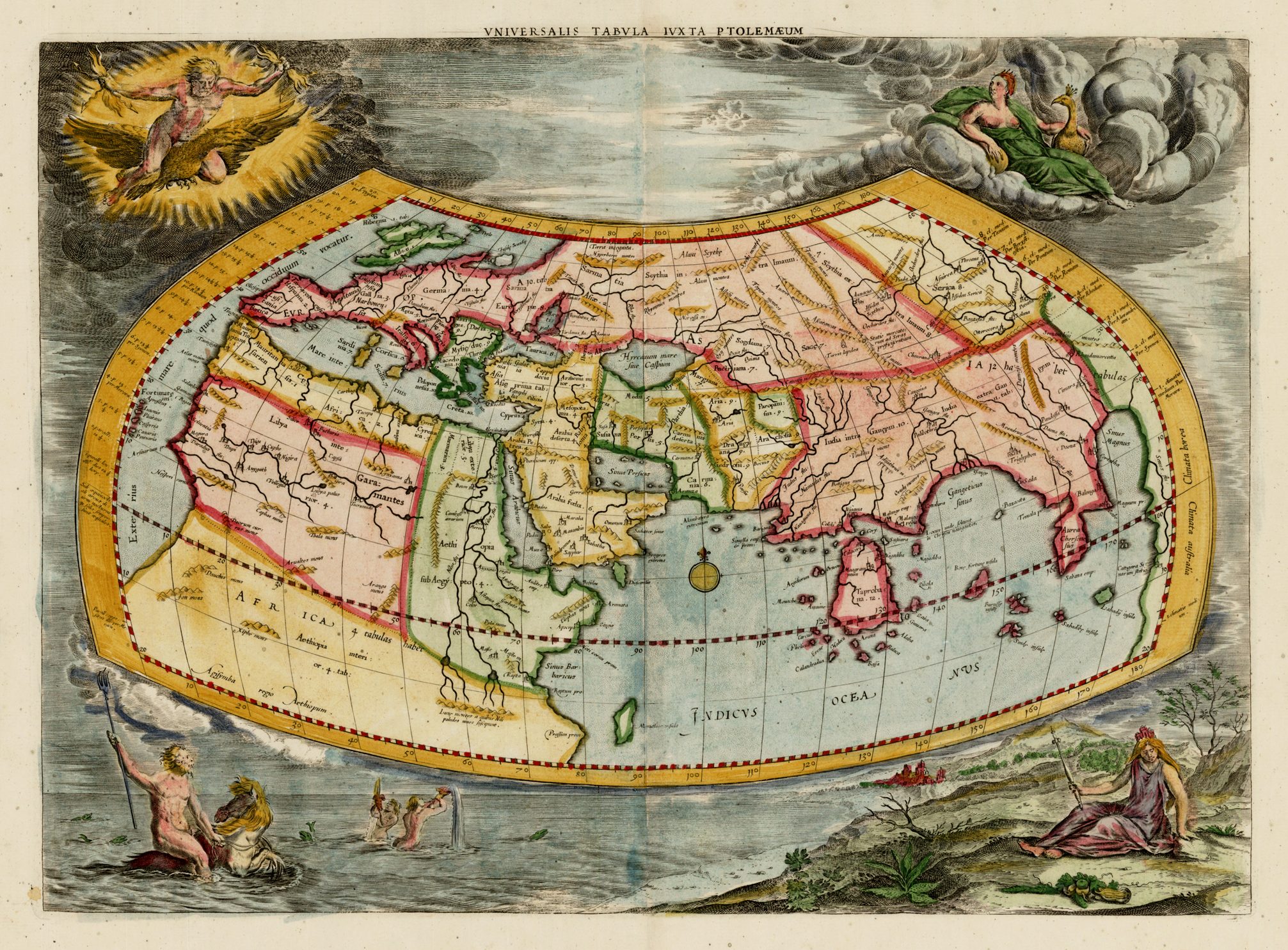
Another of Ptolemy’s errors was a belief that a southern continent existed, which counter-balanced the weight of the land-masses in the northern hemisphere, to keep the earth stable on its axis. This belief can be seen in the world map, where the southern continent forms a continuous land-link from Africa to South East Asia, with the Indian Ocean landlocked.
In the text of the Geographia, Ptolemy discussed the principles of Geography, introducing the subject thus –
Geography is a representation in picture of the whole known world with the phenomena which are contained therein … It is the prerogative of Geography to show the known habitable earth as a unit in itself, how it is situated and what is its nature; and it deals with those features likely to be mentioned in a general description of the earth, such as the larger towns and the great cities, the mountain ranges and the principal rivers. Besides these it treats only of features worthy of special note on account of their beauty …
Following the fall of the Roman Empire, Ptolemy’s text was lost to western geographers but, fortunately, the original text was translated into Arabic, for distribution among Islamic scholars and geographers, and was thereby preserved. In fact, the earliest extant manuscript version of the Geographia is Arabic, and probably dates from the 12th Century. Subsequently, the text was translated into Greek, and circulated through the Greek World.
In about 1400 or a little later, a Greek manuscript came into the hands of the Byzantine scholar, Emanuel Chrysolaras, who was working in Italy. Chrysolaras undertook a translation of the text into Latin, which was subsequently completed by his pupil Jacopo d’Angelo, in 1406. Angelo’s translation was used as the basis for the many 15th century manuscript and printed versions.
There is, however, some debate as to whether the printed maps are engraved versions of original maps which were passed down with manuscripts of the text, or whether the maps were constructed at a later date, from Ptolemy’s text, by medieval Greek scholars, or fifteenth century European mapmakers. Contemporary scholarship seems more inclined to the latter conclusion, for example, Tony Campbell wrote:
Since the oldest Ptolemaic maps date only from the late thirteenth century, it is unlikely that Ptolemy actually compiled any of the maps that illustrate his treatise .. However, the very emphasis of the text would seem to confirm that Ptolemy was working with, and from maps, a view taken by Dr. Joseph Fischer.
It is known that the world map can be attributed to Agathadaimon, whose name is often found attached to the full set of maps. Although when he actually lived is uncertain, he probably worked circa 250 A.D.
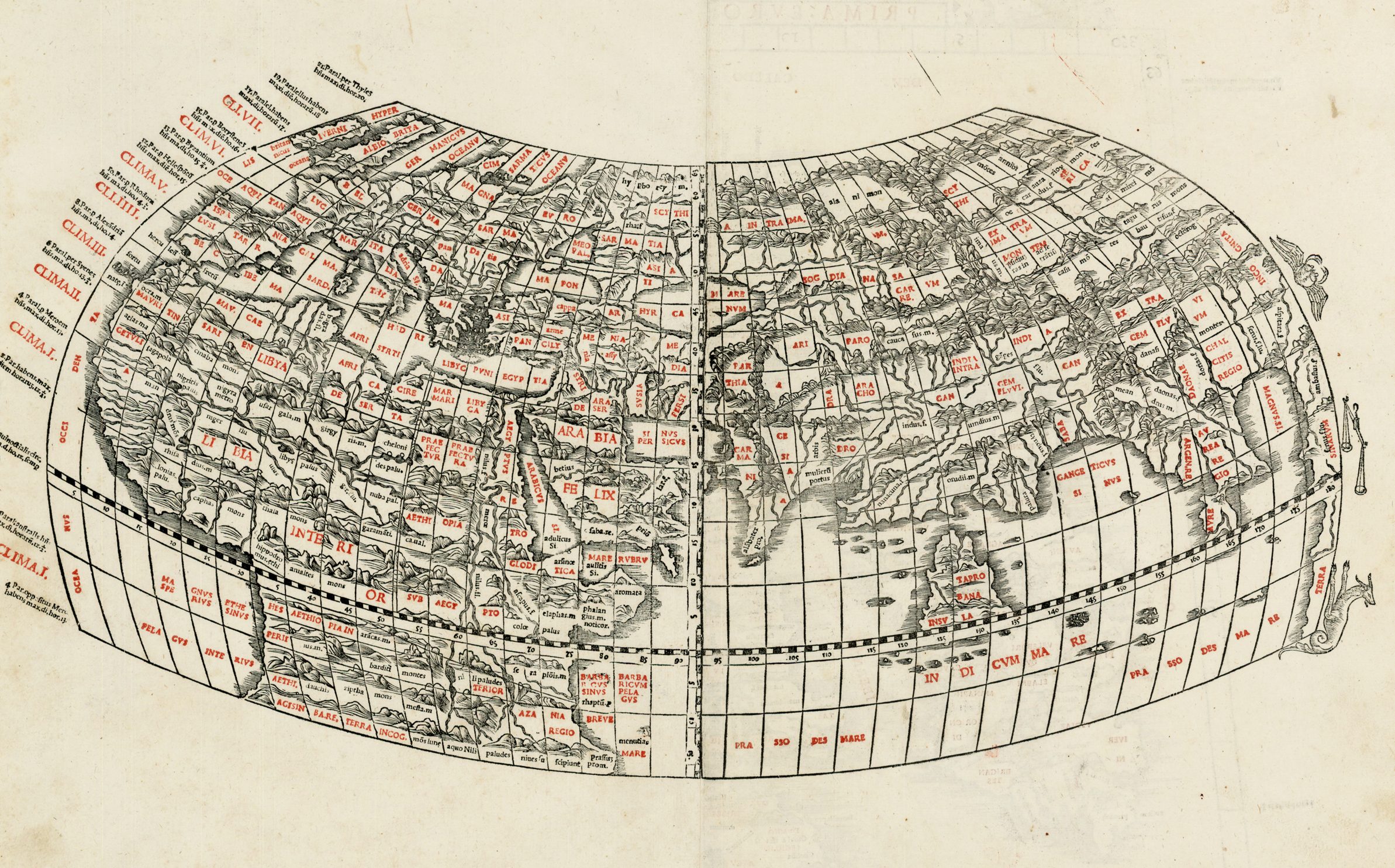
Whatever their origin, two different sets of maps are associated with manuscript versions of the Geographia – the so-called “A” and “B” groups. The latter consists of a map of the world and 64 maps of the Roman provinces. The former comprises a world map and 26 maps of countries, and it is this group that was the basis for maps in the printed editions.
This group contained a map of the World, ten maps of parts of Europe (including separate maps of Britain, Spain, France, Germany, Italy, Russia and Greece, for example), four of North Africa, and twelve of Asia (including a general map of the Levantine countries, Persia, Arabia, South East Asia, India and Ceylon).
The re-discovery of Ptolemy’s text created great excitement, and a large number of manuscript and printed editions were undertaken. The maps were far in advance of anything most people had seen, with the exception of the manuscript charts – portolani – devoted to the Mediterranean World, being produced in the principal sea-ports of Italy and Spain. Yet, Ptolemy’s maps depicted the World as it was known nearly fourteen hundred years earlier. While this may not have seemed so important in 1477, the limitations of the maps were exposed by the Portuguese discoveries in Africa, and Columbus’ crossing of the Atlantic, as Southern Africa, the East Indies, Japan and the Americas were wholly omitted from Ptolemy’s world view. These same limitations also apply to the maps of Europe, which retained out-dated perceptions, for example the west-east orientation of Scotland on maps of the British Isles.
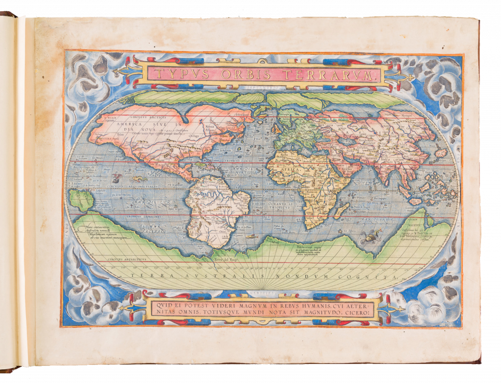
Such was the impact of Ptolemy’s maps that, from 1477 to 1570, no terrestrial atlas was published that did not contain at its core his text and maps. Abraham Ortelius’ Theatrum Orbis Terrarum, published in Antwerp in 1570 was the first that was wholly composed of modern maps of the world and its regions.
The Greek manuscript that Angelo translated was apparently lacking maps, but the data in the text contained the information to construct a set of maps, and numbers of scholars set about such work. Of them, the most influential was Donnus Nicolaus Germanus, a German cartographer, active in Italy from the 1460’s to 1480’s. He was a prolific editor of the text and maps, and his work formed the basis for three of the four sets of Ptolemaic maps printed in the fifteenth Century, with the fourth, accompanying Berlinghieri’s Geographia, “strongly influenced” by him .
While a large number of manuscript versions of the Geographia were prepared in the course of the fifteenth century, the invention of printing, midway through the century, and its subsequent application to printing images, that enabled Ptolemy’s text to achieve the wide circulation it was to enjoy.
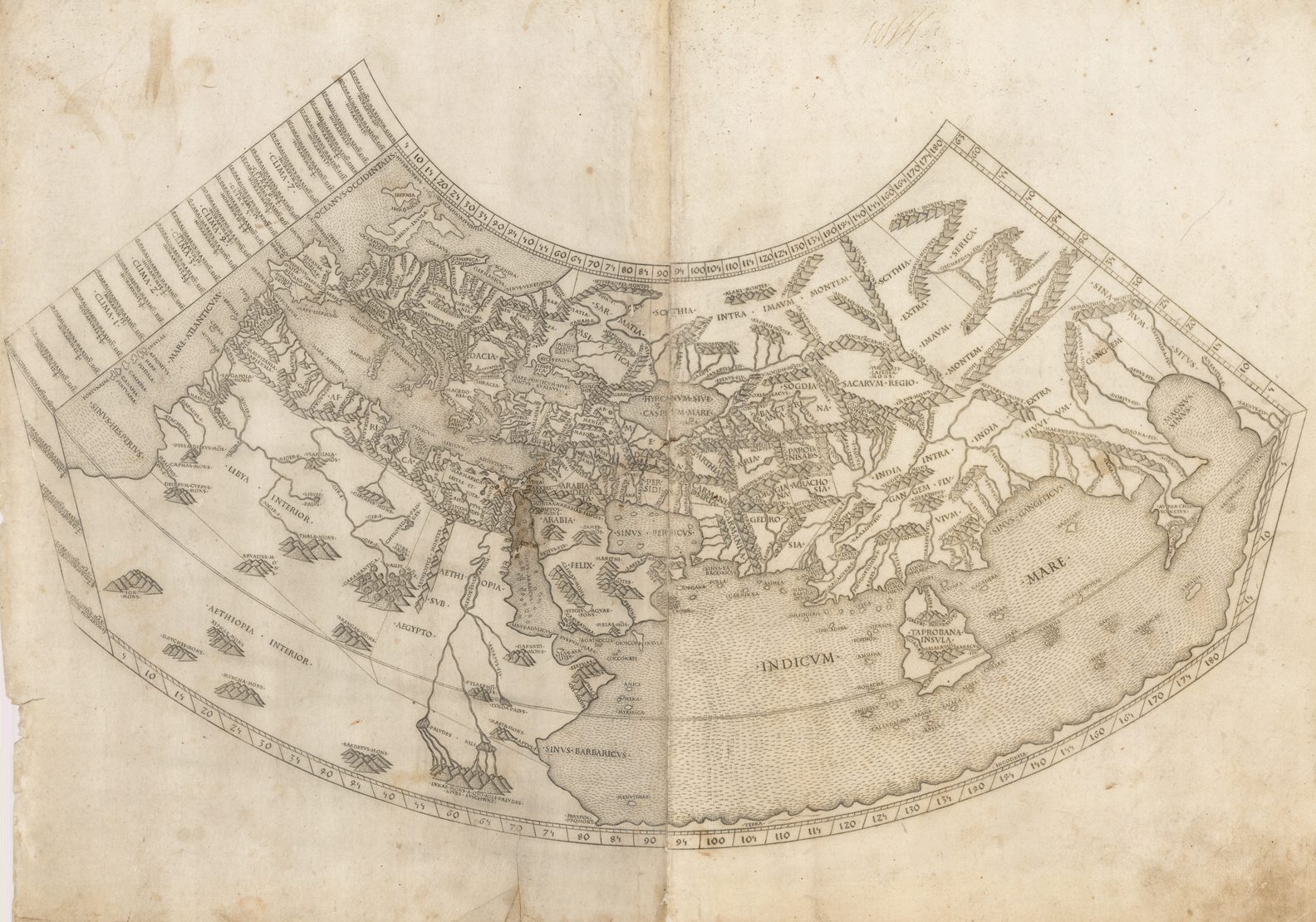
The first published edition of the Geographia with maps, which were probably engraved by Taddeo Crivelli, was issued in Bologna in 1477. Unusually, this edition contained 26 maps, with one of the Asia maps divided up among three neighboring sheets. With the exception of Palestine, these are the first regional maps of any of these various countries.
Unfortunately for the undertakers, this atlas seems not to have been a commercial success, and today only twenty-six examples of the atlas are recorded, with all but one in institutional libraries.
One explanation of the failure is that the publishers do not seem to have been fully mastered the intricacies and problems of engraving, and printing from, copper-plates, an art, which, after all, was very new and experimental. These problems were more successfully addressed by a German printer, Conrad Sweynheym, who was working on an edition of Ptolemy in Rome in the same period. Unfortunately, he did not live to see the volume appear, but his successor, Arnold Buckinck, saw the atlas through the press, in 1478.
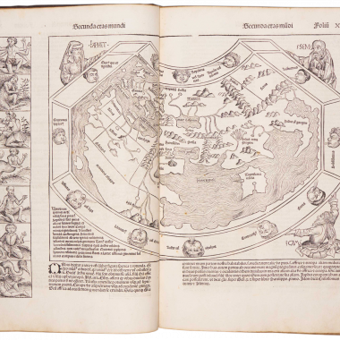
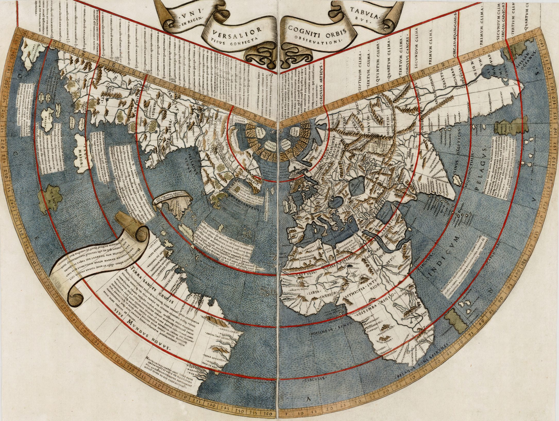
World Map from the 1478 Rome edition of Ptolemy’s Geography
The Rome Ptolemy contained 27 maps, with the same geographical coverage as the 1477 Ptolemy. Of the engraved editions of Ptolemy’s Cosmographia the maps in the Rome edition are the finest fifteenth century examples, and second only to Mercator’s maps, from his 1578 edition. One explanation for this was the use of individual punches to stamp letters onto the printing plates, rather than engraving them. This allowed much greater uniformity than lettering-engravers were able to achieve, and gives a very pleasing overall effect. The atlas proved popular, and three successive editions (to 1508) followed, although only about forty examples of the first edition are recorded today.
In 1482, Nicolas Laurentii published a set of Ptolemaic maps to illustrate Francesco Berlinghieri Geographia, a geographical description of the world, drawing on classical authors, augmented with more modern writings. The significance of the set of the maps is that it includes four supplementary modern maps, of Spain, France, Italy and Palestine, the first three the first modern maps of the respective countries.
The first edition of Ptolemy’s Geographia printed outside Italy was published by Lienhart Holle, in Ulm, also in 1482. Working independently of Berlinghieri, but apparently using the same or similar models, Holle also added modern maps of Spain, France, Italy and Palestine, but also the first printed map of Scandinavia, composed by Cornelius Clavus, circa 1425-7. Holle’s maps were printed from woodcuts, and are characterised by heavy wash colouring for the sea areas, typically a rich blue for the 1482 edition, and an ochre for the 1486 edition. These bright colours, and the greater sense of age that woodcuts convey, make this series the most visually appealing of these various sets of maps.
For the 1507 (third) edition of the Rome Ptolemy, one of the editors, Marco Beneventanus, prepared new maps of France, Spain, Italy, Scandinavia, central and eastern Europe and Palestine. With the exception of the Eastern European map, which was drawn by Bernard Wapowski, the other maps were based on those in the Ulm Ptolemy.
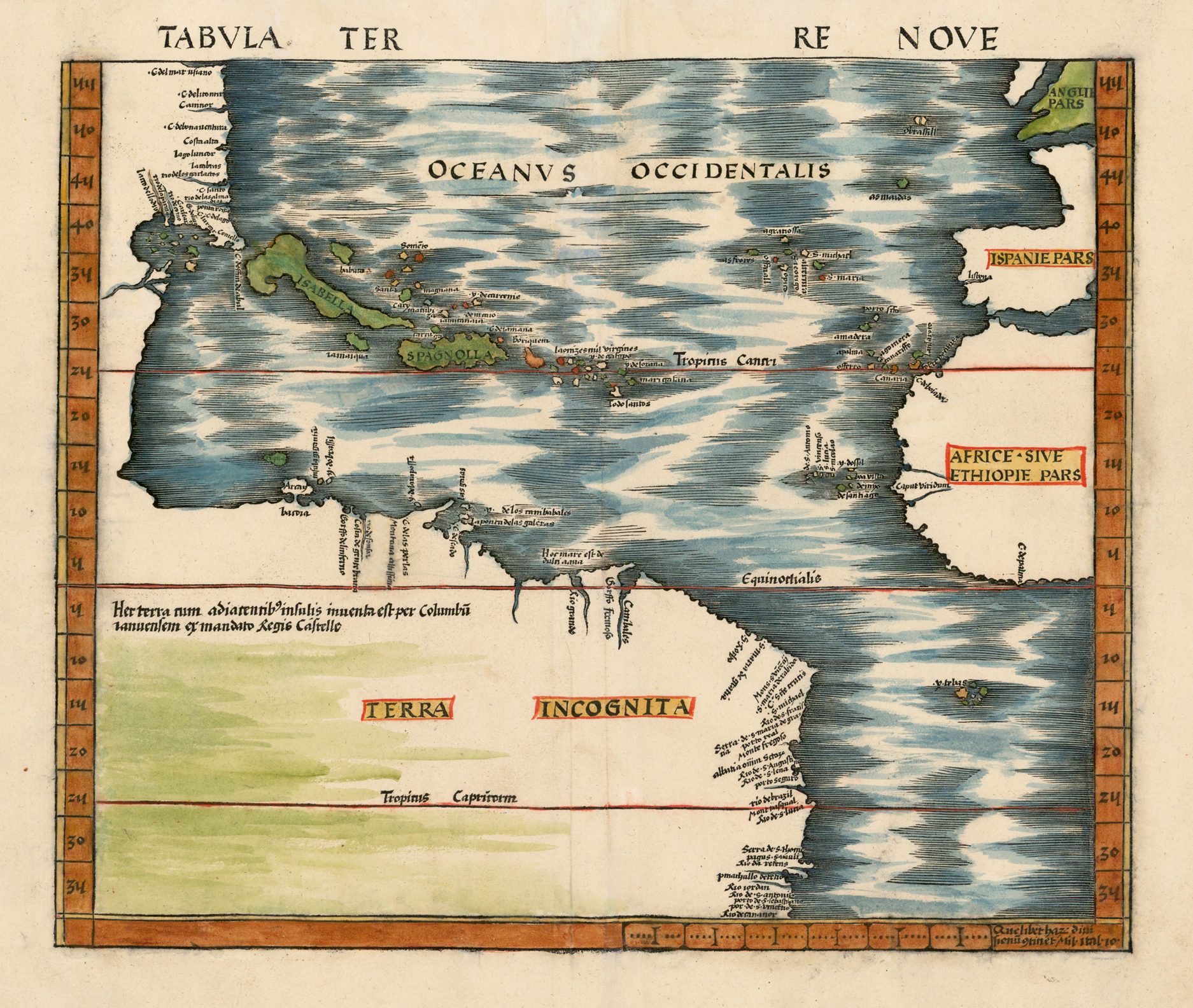
By now, the limitations of Ptolemy’s maps had become clear, and from the end of the fifteenth century onwards, the great overseas discoveries started to appear on printed maps. The 1508 edition (and late issues of the 1507 edition) of the Rome Ptolemy contains Johannes Ruysch’s map of the World, which is highly prized as the earliest available map to mark any part of the Americas.
Next in chronological sequence, and the most unusual of the editions of Ptolemy, was that published by Jacobus Pentius de Leucho in Venice in 1511, edited by Bernardus Sylvanus. Sylvanus, realizing the geography was outdated, attempted to update the maps by inserting more modern information, often from contemporary manuscript sources, over the Ptolemaic material, creating an unusual effect. An innovative feature is that the maps, which are printed from woodblocks, are printed in two colors, red and black, with the principal names in red. In addition to the Ptolemaic set, Sylvanus also included a modern map of the World, on a cordiform, or heart-shaped projection. Visible along the western border are eastern South America, Cuba and Hispaniola, and the tip of Labrador or Newfoundland.
Martin Waldseemüller’s edition of Ptolemy, first published in 1513, is the most important of the sixteenth century editions. The atlas, with the maps printed from woodblocks, contains a separate, additional section, with twenty modern maps. This section has been described as the first modern atlas, as the first attempt to break away from the Ptolemaic tradition. The most important of these maps is a separate map of the West Indies and part of the Gulf Coast, which is the first in an atlas devoted to the Spanish discoveries in the New World, but there were also maps of Southern Africa, of the Middle East, and Southern Asia.
It has long been known that Waldseemüller’s edition had a difficult path to press. Much of the work was done in about 1507 or 1508, but it was not until 1513 that the atlas was actually printed. An important discovery, made by London dealer Jonathan Potter, has cast new light on the earliest phase of the development of the atlas. One of the modern maps added by Waldseemüller was of Lorraine. It is the only map in the atlas printed in color (black, red and brown). All the other maps were printed black and white. Recently, Jonathan Potter acquired an example of the Ptolemaic map of the British Isles (the first of the regional maps in the atlas), in which the sea area was printed in color, from a second block. This would seem to suggest that the initial plan was to print all the maps in this fashion, but for some reason, this plan was not carried through, presumably because of the technical problems involved.
Waldseemüller’s edition proved particularly influential, and served as a model for subsequent Ptolemaic atlases. As these atlases were relatively standard, the following notes will only highlight the more important additional maps added by subsequent editors.
Waldseemüller’s edition was reprinted in 1520, and then the maps were re-drawn by Lorenz Fries on a smaller format, for editions published in 1522, 1525, 1535 and 1541. While largely a copy of Waldseemüller’s edition, Fries also added three new maps: a World map, the first in an edition of Ptolemy to name “America”, and the first printed maps of South East Asia with the East Indies, and of China and Japan.
The next to produce an edition of Ptolemy was Sebastian Munster, who worked in Basle. Munster was one of the leading geographers and cartographers of his period, and he diligently set about revising and improving the maps. His first edition, published in 1540, is notable as containing the first set of maps of the four known Continents. The Americas map is the first separate map of that Continent, while the other Continents had previously been depicted in other publications.
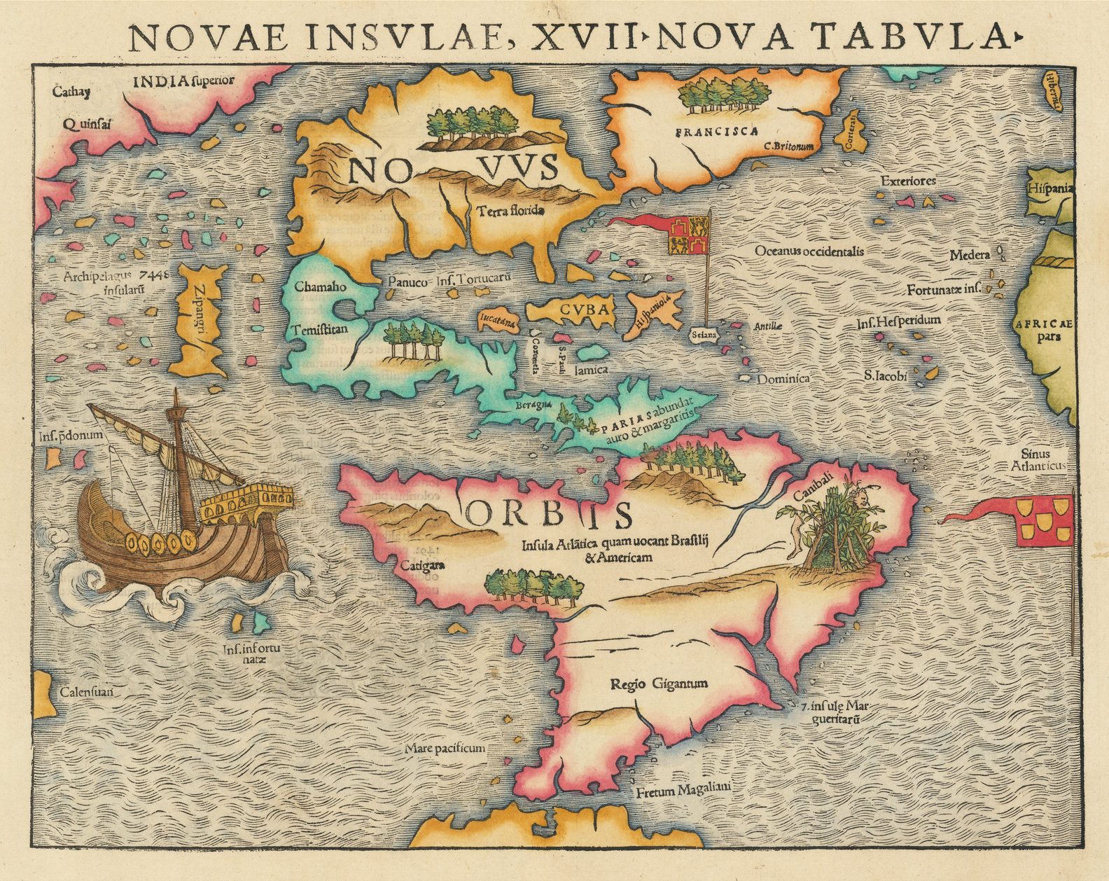
Giacomo Gastaldi, one of the leading cartographers of the sixteenth century, composed a set of maps for an edition of the Geographia, published in Venice in 1548. It is among the earliest examples of his work, in a long and distinguished career. This edition was the first pocket-sized edition. Despite being prepared on a small format, the maps are clearly and attractively engraved. Gastaldi was the first to add regional maps of the American continent, with important maps of the eastern seaboard, a map of what is now the southern United States, of South America, and separate maps of Cuba and Hispaniola.
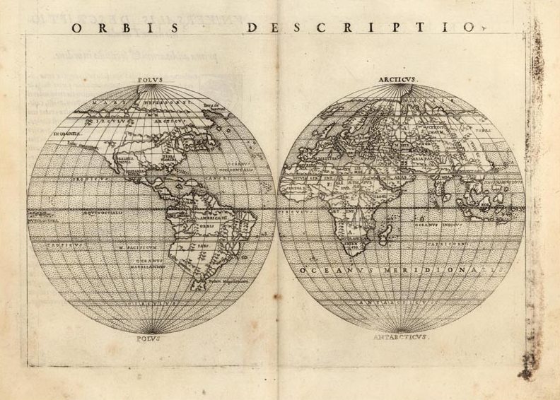
Gastaldi’s maps were re-engraved on a slightly larger format for an edition published by Vincenzo Valgrisi, in Venice, in 1561, and re-issued up to 1599. For this edition, Valgrisi (or the editor Girolamo Ruscelli) added four maps: a double-hemisphere map of the World (the first appearance of this projection in an atlas), a map of Brasil, and a map of the northern Atlantic, a copy of the “Zeno” map, which was alleged to have been drawn by two brothers, Nicolo and Antonio Zeno in 1380, and published by their descendant Caterino Zeno in 1558. While now considered to be faked by that descendant, the map is still a remarkably good depiction of southern Greenland and Iceland and, in the Valgrisi version, achieved a wide distribution.
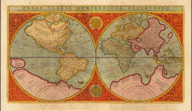
Of all the editions of Ptolemy, that prepared by Gerard Mercator, and published in 1578, is technically the finest, with the World map being a particularly fine engraving. By this time, Ptolemy’s Geographia had lost any pretense of being a “current” atlas. Instead Mercator’s intention was to produce an atlas of the classical world, that would serve as a companion to his modern atlas, as one part of a description of the universe. As such, Mercator attempted to return to the pure form of the original Ptolemaic atlas, discarding the modern accretions. As it happened, however, only the classical atlas appeared in Mercator’s lifetime. The atlas is, also, noteworthy for its longevity, the original printing plates were still in use in 1730, over one hundred and fifty years after they were first engraved.
The last two editions of Ptolemy to add new sets of map plates were published in 1596 and 1597. The first was published by Giovanni Antonio Magini in Venice in 1596, and almost immediately pirated by Petrus Keschedt, a Cologne publisher, with the maps from the two editions being almost indistinguishable.
For a series of maps that depicted the Hellenistic World of the second century A.D., Ptolemy’s maps and text had a remarkable longevity. In many ways, the popularity of the Geographia cast a heavy burden on publishers of the late fifteeen and first half of the sixteenth centuries, but the evident limitations of the work also proved an important incentive to individual mapmakers, such as Waldseemüller, Gastaldi, Mercator and others to look beyond Ptolemy’s work, and lay the foundations of modern cartography.
| 300 Year | Atlas Title Colophon Publisher’s Details | Ptol. maps | Mod. maps | Notes |
| 1477 | [The Bologna Ptolemy] Cosmographia … Hic Finit Cosmographia Ptolemei Impressa Opa Dominici De Lapis Ciuis Bononiensis Anno . M . CCCC . LII . Mense Ivnii . XXIII Bononie … [The date is accepted as a misprint for 1477] Domenico de LAPIS, [For Giovanni degli ACCURSI, Ludovico & Domenico de’ RUGGERI & Taddeo CRIVELLI] Bologna, 1462 [ie 1477]. | 26 | – | Based on Jacobo d’Angelo’s translation of Ptolemy’s text, which was proofed by Pietro Bono and Girolamo Manfredi, and then corrected by Galleoto Marzio and Nicolo di Guggio, with a final revision carried out by Filippo Beroaldo; the maps were compiled by Bono and Manfredi, and drawn by Taddeo Crivelli. |
| 1478 | [The Rome Ptolemy] Claudii Ptholomei Alexandrini. Cosmographia… … Arnoldvs Bvckinck E Germania Rome Tabvlis Aeneis In Pictvris Formatam Impressit. Sempiterno Ingenii Artificiiqve Monvmento. Anno Dominici Natalis. M.CCCC. LXXVIII VI Idvs Octobris. Sedente Sixto. IIII Pont. Max. Anno Eivs. VIII. Arnold BUCKINCK, Rome, 1478. | 27 | – | |
| 1478 | [another edition] Geographia. Hoc Opvs Ptholomaei … Impressvm Fvit Et Completvm Rome Anno A Nativitate Domini, M. CCCC. LXXXX. Die. IV. Novembris. Arte Ac Impensiis Petri De Tvrre. Petrus de TURRE, Rome, 1490. | 27 | – | |
| 1478 | [another edition – Marco BENEVENTANUS & Giovanni COTTA ed.] In Hoc Operae Haec Contine[n]tur Geographia Cl. Ptholemaei … Schemata Cum Demonstrationibus Suis Correcta a Marco Monacho Caelestino Beneventano: & Ioanne Cota Veronesi Viris Mathematicics Consultissimis. Sex Tabulae Nouiter Co[n]fectae … Planisphaerium Cl. Ptholemaei Nouiter Recognitum & Diligentiss. Emendatum a Marco Monacho Caelestino Beneventano … … Rome Nouiter Impressum Per Bernardinu[m] Venetu[m] De Vitalibus. Expe[n]sis Eua[n]gelista Tosino … Die VIII. Septe[m]br. M.D. VII. Bernardinus VENETUS DE VITALIBUS, For Evangelista TOSINUS, Rome, 1507. | 27 | 6/7 | The modern maps were edited by Beneventanus; Johannes Ruysch’s world map is sometimes found, although commissioned for the 1507 edition, it was not completed in time, and properly belongs to the 1508 edition, where it is mentioned on the title-page. |
| 1478 | [another edition. Marco BENEVENTANUS & Giovanni COTTA ed.] In Hoc Opere Haec Continentur Geographia Cl. Ptolemaei … Noua Orbis Descriptio Ac Noua Oceani Navigatio Qua Lisbona Ad Indicu Pervenitur Pelagus Marco Beneventano. Aedita. Noua & Universalior Orbis Cogniti Tabula Ioa. Ruysch Germano Elaborata … M D.VIII. Rome. … Rome Nouiter Impressum Per Bernardinu[m] Venetu[m] De Vitalibus. Expe[n]sis Eua[n]gelista Tosino … Die VIII. Septe[m]br. M.D. VII. Bernardinus VENETUS DE VITALIBUS, For Evangelista TOSINUS, Rome, 1508. | 27 | 7 | Including Johannes Ruysch’s world map: Vniversalior Cogniti Orbis Tabula. Ex Recentibus Confecta Observationibus. Printed from two printing plates, found in several variant states. |
| 1482 | [Francesco Berlinghieri. Geographia] In Qvesto Volvme Si Contengono Septe Giornate Della Geographia Di Francesco Berlingeri Fiorentino Allo Illvstrissomo Federico Dvca Dvrbino. Nicolaus LAURENTII, For Francesco BERLINGHIERI, Florence, 1482. | 27 | 4 | The text is a paraphrase of Ptolemy’s text, in Italian verse, also combining classical and contemporary authors and texts, The Ptolemaic regional maps are drawn on Marinus’ plane projection. Three of the modern maps (Spain, France & Italy). The prototypes of the three European maps were drawn by Pietro del Massaio, and illuminated by Hughes Commineau; the Palestine map derives from Pietro Vesconte’s map, drawn for Marino Sanudo. [Although not generally considered an edition of Ptolemy, the maps are the only examples of Ptolemy’s maps to be drawn on the original projection, with equidistant meridians and parallels.] |
| 1482 | [another edition: Geographia’] Impresso Infirenze Per Nicolo Todescho & Emendato Con Somma Diligentia Dallo Auctore. Nicolaus LAURENTII, [For Francesco BERLINGHIERI], Florence, [1482]. | 27 | 4 | The register and colophon are printed on the recto of the last leaf. |
| 1482 | [The Ulm Ptolemy – Nicolaus Germanus ed.] [Cosmographia.] Claudii Ptolomei …. Cosmographie … Opus Donni Nicolai Germani Secvndvm Ptolomevm Finit. Anno MCCCCLXXXII. … Impr[e]ssvm Vlme Per Ingeniosvm Virvm Leonardvm Hol. Prefat. Oppidis Civis. Lienhart Holle, Ulm, 1482. | 27 | 5 | 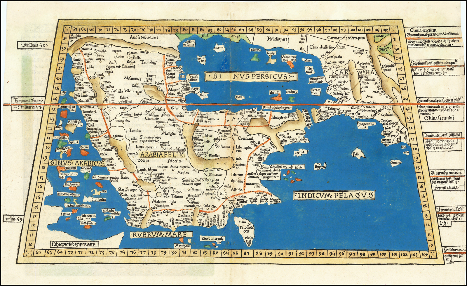 The five modern maps are France, Spain, Scandinavia, Italy and Palestine, printed from woodblocks |
| 1482 | another edition: [Cosmographia] Impressvm Vlme Opera Et Expensis Ivsti De Albano De Venetiis Per Provisorem Svvm Iohannem Reger. Anno Domini . M. CCCC. LXXXVI … Johann Reger, for Giusto de Albano, Ulm, 1486. | 27 | 5 | |
| 1511 | [Bernard Sylvanus ed.] Clavdii Ptholemaei Alexandrini Geographiae Cvm Tabvlis … Venetiijs Per Iacobum Pentium De Leucho Anno Domini. M. D. XI. Die XX. Mensis Marti. Jacobus Pentius de Leucho, Venice, 1511. | 27 | 1 | Includes a modern map of the world (Shirley: 32). |
| 1513 | [Martin Waldseemuller & Matthias Ringmann ed.] Clavdii Ptolemei Viri Alexandrini … Geographie Opus Novissima Traductione E Grecorum Archetypis Castigatissime Pressum … Anno Christi Opt. Max. M D XIII. Marcii XII. Pressus Hic Ptolemeus Argentine Vigilantissima Castigatione Industriaq[ue] Ioannis Schotti Urbis Indigene Regnante Maximiliano Caesare Semper Avgvsto. Secvnde Partis Ptolemaei Finis Opera Ioannis Schotti Argentinen. Anno Christi Opt. Max. 1513. Johann Schott, for Jacob Aeszler & Georg Uebelin, Strasbourg, 1513. | 27 | 20 | The modern maps, all woodcuts, are in a separate section. |
| 1513 | [another edition] Ptolemaevs Avcts Restitvtvs, Emacvlatvs, Cvm Tabvlis Veteribvs Ac Novis. Caroli V. Imperii Anno I. Vim Vi Repellere Licet Ioannes Scotus, Argentorati Literis Excepit. 1520. Johann Schott, Strasbourg, 1520. | 27 | 20 | 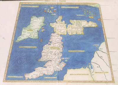 |
| 1522 | [Lorenz Fries] Claudii Ptolemaei Alexandrini Mathematicor[um] Principis Opus Geographi[a]e Noviter Castigatu[m] & Emaculatu[m] … Hec Bona Mente Laure[n]tius Phrisus Artis Appollone[a]e Doctor & Mathematicar[um] Artium Clientulus, In Lucem Iussit Prodire. Agammemnonis Puteoli Plurimu[m] D[e]dicati. Ioannes Grieninger Civis Argentoraten[sis] Opera Et Expensis Propriis Id Opus Insigne, [A]ereis Notulis Excepit … XII Die Marcii Anno M.D.XXI Johann GRUNINGER, Strasbourg, 1522. | 27 | 23 | The preface was written by Thomas VOGLER; 50 maps, most reduced from Martin Waldseemuller’s 1513 edition. |
| 1522 | [another edition: Wilibald PIRCKHEIMER ed.] Claudii Ptolemaei Geographicae Enarrationis Libri Octo Bilibaldo Pirckeymhero Interprete Annotationes Ioannis De Regio Monte In Errores Commissos A Iacobo Angelo In Translatione Sua. …Argentorati, Iohannes Grieningerus, Communibus Iohannes Koberger Impensis Excudebat. Anno A Christi Nativitate M.D. XXV. Tertio Kal. Apriles.’ Johann GRUNINGER, For Johann KOBERGER, Strasbourg, 1525. | 27 | 23 | The text was translated by Wilibald PIRCKHEIMER, using the notes of Johannes REGIOMONTANUS, perhaps under the editorship of Johann HUTTICH; the ornamental woodblock designs on the reverse of the maps are attributed to Albrecht DURER, who also contributed the woodblock of the armillary sphere. |
| 1522 | [another edition: Michael SERVETUS ed.] Claudii Ptolemaei Alexandrini Geographicae Enarrationis. Libri Octo. Ex Bilibaldi Pirckeymheri Tra[ns]Latione, Sed Ad Graeca & Prisca Exemplaria À Michaele Villanovano Iam Primum Recogniti. Lugduni Ex Officina Melchioris Et Gasparis Trechsel Fratrum. M.D. XXXV. Melchior & Gaspar TRECHSEL, Lyons, 1535. | 27 | 23 | The text was newly edited by SERVETUS from Wilibald PIRCKHEIMER’s text, used in the previous edition; the woodblock designs on the reverse of the maps are said to be the work of Hans HOLBEIN the Younger and GRAF. (Pastoureau, Ptolémée, E) |
| 1522 | [another edition: Michael SERVETUS ed.] Claudii Ptolemaei Alexandrini Geographicae Enarrationis Libri Octo Ex Bilibaldo Pirckeymheri Tra[ns]latione, Sed Ad Graeca & Prisca Exemplaria À Michaële Villanovano Secundo Recogniti & Locis Innumeris Denuo Castigati. … Prostant Lugduni Apud Hugonem À Porta. [Hughes de la PORTE] Gaspar Trechsel Excvdebat Viennae. [rule] M D XLI. Gaspar TRECHSEL, Vienne, 1541 | The text was again re-edited by SERVETUS from PIRCKHEIMER’s text. (Pastoureau, Ptolémée, F) | ||
| 1540 | [Sebastian MUNSTER ed.] Geographia Vniversalis, Tvm Vetvs Et Nova, Complectens Clavdii Ptolemaei Alexandrini Enarrationis Libros VIII. … Succedunt Tabulæ Ptolemaice, Opera Sebastiani Munster Nouo Paratæ Modo. His Adiectæ Sunt Plurime Nouæ Tabulæ … Basileae Apvd Henricvm Petrvm Mense Martio Anno M. D. XL. Heinrich PETRI, Basle, 1540. | 27 | 21 | The text is based on Wilibald PIRCKHEIMER’s translation, from Lorenz FRIES’ editions; each map has, on the reverse, a brief descriptive text, surrounded by woodblock borders, which are attributed to Hans HOLBEIN the Younger. |
| 1540 | [another edition] Geographia Vniversalis, Vetvs Et Nova … Basileae Apvd Henricvm Petrvm. Basileae Apvd Henricvm Petrvm Mense Martio AN M.D.XLII. Heinrich PETRI, Basle, 1542. | |||
| [another edition] Geographia Vniversalis, Vetvs Et Nova … Basileae Per Henrichvm Petrvm, Anno M. D. XLV. Basileae Per Henrichvm Petrvm Mense Martio AN M.D.XLV. Heinrich PETRI, Basle, 1545. | ||||
| 1540 | [another edition] Geographiae Claudii Ptolemaei. Partim A Bilibaldo Pirckheymero Translati Ac Commentario Illustrati, Partim Etiam Graecorum Antiquissimorumq Exemplariorum Collatione Emendati Atque In Integrum Restituti … Facillima Ratione In Tabulis Depictis Deprehendu[n]tur, Conradi Lycosthenis Rubeaque[n]sis Opera Adiecti. Tabulae Nouae Quae Hactenus In Nulla Ptolemaica Editione Uisae Sunt, Per Sebastianum Munsterum. Geographiae Descriptionis …’ [Conrad LYCOSTHENES] Basileae Ex Officina Henrichii Petri, Mense Martio, Anno M. D. LII.’ Heinrich PETRI, Basle, 1552. | The text was partly based on Willibald PIRCKHEIMER’S translation, used in editions of the PTOLEMY / FRIES; a short treatise ‘De Utilitate Tabularum Geographicarum’ by Conrad LYCOSTHENES was added | ||
| 1548 | [Pietro Andrea MATTIOLI ed.] Ptolemeo. La Geografia … Nicolo BASCARINI, For Giovanni Battista PEDREZANO, Venice, 1548. | 26 | 34 | Maps prepared by Giacomo Gastaldi. There was no Ptolemaic world map and two modern ones. |
| 1561 | [Girolamo RUSCELLI ed] La Geografia Di Clavdio Tolomeo Alessandrino, Nuouamente Tradotta Di Greco In Italiano, Da Girolamo Rvscelli … Aggiuntoui Vn Pieno Discorso Di M. Gioseppe Moleto … In Venetia, Appresso Vincenzo Valgrisi, M. D. LXI. Vincenzo VALGRISI, Venice, 1561. | 27 | 37 | With an additional ‘Discorso Universale’ by Gioseppe MOLETIUS. The maps were based on those in the 1548 edition by Giacomo GASTALDI, and were probably engraved by Giulio SANUTO under the direction of his brother, Livio SANUTO |
| 1561 | [another edition: Giuseppe MOLETO ed.] Geographia Cl. Ptolemaei … Olim A Bilibaldo Pirckheimherio Tra[n]slata, At Nunc Multis Codicibus Graecis Collata, Pluribusque In Locis Ad Pristinam Ueritatem Redacta A Iosepho Moletio Mathematico … Venetiis, Apvd Vincentivm Valgrisivm. M D LXII. Vincenzo VALGRISI, Venice, 1562. | MOLETO used Wilibald PIRCKHEIMER’s translation, from the 1525 Strasbourg edition, as a basis | ||
| 1561 | [another edition: Giuseppe MOLETO ed.] Geographia Cl. Ptolemaei … Venetiis, Ex Officina Stellae, Iordani Ziletti. M D L XIIII. Giordano ZILETTI, Venice, 1564. | Nordenskiold Collection Catalogue, II, 218 | ||
| 1561 | [another edition: RUSCELLI ed.] La Geografia Di Clavdio Tolomeo Alessandrino, Nuouamente Tradotta Di Greco In Italiano, Da Ieronimo Rvscelli … In Venetia, Appresso Giordano Ziletti, Al Segno Della Stella, M. D. LXIIII. Giordano ZILETTI, Venice, 1564 | |||
| 1561 | [another edition [Giovanni MALOMBRA ed.] La Geografia Di Clavdio Tolomeo Alessandrino, Già Tradotta Di Greco In Italiano, Da Giero[nimo] Rvscelli: & Hora In Questa Nuoua Editione Da M. Gio. Malombra Ricorretta, & Purgata D’Infiniti Errori… In Venetia, Appresso Giordano Ziletti M. D. LXXIIII.’ Giordano ZILETTI, Venice, 1574. | 27 | 38 | The text is RUSCELLI’s translation, edited by MALOMBRA, with a new modern map, of the ‘Territorio di Roma’, added. |
| 1561 | [another edition: [Giuseppe ROSACCIO ed.] Geografia Di Clavdio Tolomeo Alessandrino, Tradotta Di Greco Nell’Idioma Volgare Italiano Da Girolamo Rvscelli, Et Hora Nuouamente Ampliata Da Gioseffo Rosaccio… In Venetia, M D XCVIII. Appresso Gli Heredi Di Melchior Sessa. HEIRS OF MELCHIOR SESSA, Venice, 1598. | 27 | 43 | additional maps of the World and four continents |
| 1561 | [another edition: [Giuseppe ROSACCIO ed.] Geografia Di Clavdio Tolomeo Alessandrino… In Venetia, M D XCIX. Appresso Gli Heredi Di Melchior Sessa. HEIRS OF MELCHIOR SESSA, Venice, 1599. | |||
| 1578 | [Gerard MERCATOR ed.] Tabvlae Geographicae Cl: Ptolemei Admentem Autoris Restitutæ & Emendate Per Gerardum Mercatorem … Coloniæ Agrippinae Typis Godefridi Kempensis. Anno Virginei Partvs. M. D. LXXVIII. Godefrid von KEMPEN [for Gerard MERCATOR], Cologne, 1578. | 28 | 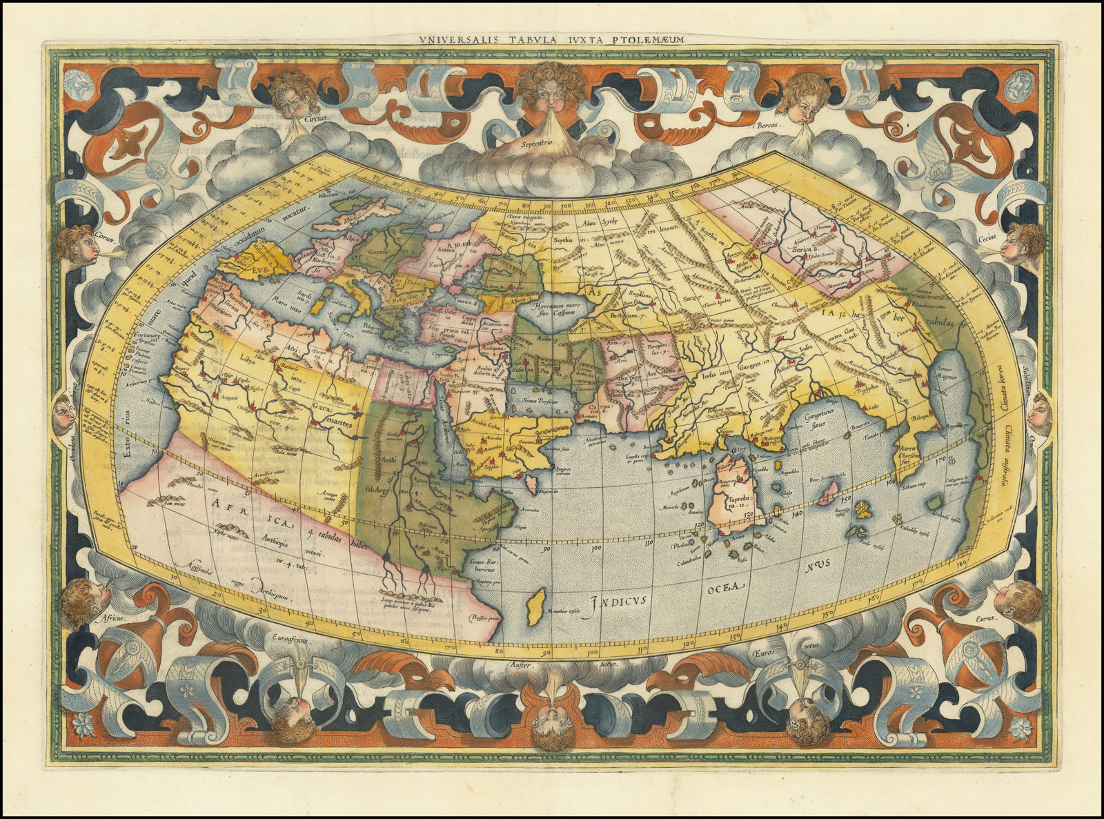 An additional map of Lower Egypt | |
| 1578 | [another edition: Arnold MYLIUS ed.] Cl. Ptolemaei Alexandrini, Geographiae Libri Octo, Recogniti Iam Et Diligenter Emendati Cum Tabulis Geographicis Ad Mentem Autoris Restitutis Ac Emendatis Per Gerardvm Mercatorem … M. D. LXXXIV. Coloniae Agrippinae Typis Godefridi Kempensis. Anno Virginei Partvs, M. D. LXXXIIII. Gottfried von KEMPEN [for Gerard MERCATOR], Cologne, 1584. | The text was edited by MYLIUS, using Michael SERVETUS’s edited version of Wilibald PICKHEIMER’S text. | ||
| 1578 | [another edition: Petrus MONTANUS ed.] Claudii Ptolemæi Alexandrini Geographiae Libri Octo Græco-Latini Latinè Primùm Recogniti Et Emendati, Cum Tabulis Geographicis Ad Mentem Auctoris Restitutis Per Gerardum Mercatorem: Iam Verò Ad Græca Et Latina Exemplaria À Petro Montano Iterum Recogniti, Et Pluribus Locis Castigati … Sumptibus Cornelij Nicolai Et Iodoci Hondij Amsterodammi. 1605. [Jan THEUNISZ.], For Jodocus HONDIUS Sr. & Cornelis CLAESZ, Amsterdam, 1605. | |||
| 1578 | [another edition: Pieter BERTIUS ed.] Theatrum Geographiae Veteris, Duobus Tomis Distinctum, Edente Petro Bertio … Theatri Geographiae Veteris Tomus Prior In Quo Cl. Ptol. Alexandrini Geographiae Libri VIII Graecé Et Latiné Graeca Ad Codices Palatinos Collata Aucta Et Emendata Sunt Latina Infinitis Locis Correcta Opera P. Bertii … Lugduni Batavorum, Excudebat Typis Suis Isaacus Elzevirus Sumptibus Iodoci Hondii, Anno 1618.’ [although the Title-page to the second part is dated 1619] Isaac ELZEVIER, Leiden, For Jodocus HONDIUS Jr., Amsterdam, 1619. | Among the contributors was Willebrord SNELLIUS. | ||
| 1578 | [another edition] Claudii Ptolemaei Tabulae Geographicae Orbis Terrarum Veteribus Cogniti. Franequerae, Apud Leonardum Strik, Bibliopolam. Trajecti Ad Rhenum, Apud Franciscum Halmam, Acad. Typograph. M.D.C.XCV. Leonard STRICK, Franeker & François HALMA, Utrecht, 1695. | The maps have been reworked, with new titles added within the maps | ||
| 1578 | [another edition] Claudii Ptolemaei Tabulae Geographicae Orbis Terrarum Veteribus Cogniti. [Engraved title] Claudii Ptolemaei Tabulae Geographicae Orbis Terrarum Veteribus Cogniti.’ [engraved by Jan van VIANEN] Trajecti Ad Rhenum, Apud Franciscum Halmam, Guiljelmum Van De Water, Bibliop. Et Franequerae, Apud Leonardum Strick, Bibliop. M.D.C.XCVIII. François HALMA & Willem van den WATER, Utrecht & Leonard STRICK, Franeker, 1698. | |||
| 1578 | [another edition] Claudii Ptolemaei Tabulae Geographicae Orbis Terrarum Veteribus Cogniti. Amstelaedami Apud Franciscum Halmam, Bibliop. Et Trajecti Ad Rhenum, Apud Guiljelmum Van De Water, Bibliop. MDCCIV. François HALMA, Amsterdam & Willem van den WATER, Utrecht, 1704. | |||
| 1578 | [another edition] Claudii Ptolemaei Tabulae Geographicae Orbis Terrarum Veteribus Cogniti. Lugduni Batavorum, Apud Viduam C. Boutestyn, & Fil. & S. Luchtmans, Bibliop. Et Trajecti Ad Rhenum, Apud Guiljelmum Van De Water, Bibliop. MDCCIV. WIDOW & SON OF C. BOUTESTYN & S. LUCHTMANS, Leiden, & Willem van den WATER, Utrecht, 1704. | |||
| 1578 | [another edition] Orbis Antiqui Tabulae Geographicae Secundum Cl. Ptolemaeum Amstelaedami, Apud R. & J. Wetstenios & Guil, Smith. MDCCXXX. Rod. & J. WETSTEIN & Willem SMITH, Amsterdam, 1730. | Text engravings drawn by G.F.L. DEBRIE and performed by K. de PUTTER, dated 1729. | ||
| 1596 | [Giovanni Antonio MAGINI ed.] Geographiae Vniversae Tum Veteris Tum Novae. Auctore Eodem Io. Ant. Magino Patavino. Venetiis, M. D. XCVI. Apud Haeredes Simonis Galignani De Karera. Heirs Of Simon GALIGNANI [ie. Giovanni Battista & Giorgio GALIGNANI], Venice, 1596. | 27 | 36 | Maps engraved by Girolamo PORRO. MAGINI added an extensive additional text. |
| 1596 | [another edition: Leonard CERNOTI trans.] ‘Geografia Cioe Descrittione Vniversale Della Terra. Nuouamente Con Singolare Studio Rincontrati, & Corretti Dall’Eccell.mo Sig. Gio Ant. Magini. Dal Latino Nell’Italiano Tradotta Dal R.D. Leonardo Cernoti. In Venetia, M. D. XCVIII. Apresso Gio. Battista & Giorgio GALIGNANI Fratelli. Giovanni Battista & Giorgio GALIGNANI, Venice, 1598. | |||
| 1596 | [another edition: Leonard CERNOTI trans.] ‘Geografia Cioe Descrittione Vniversale Della Terra. Dal Latino Nell’Italiano Tradotta Dal R.P. Leonardo Cernoti. In Padova, M. DC. XXI. Appresso Paolo, & Francesco Galignani, Fratelli. Paolo & Francesco GALIGNANI, Padua, 1621. | |||
| 1597 | [after Giovanni Antonio MAGINI] Geographiae Vniversae Tum Veteris Tum Novae …Auctore Eodem Io. Ant. Magino Patavino. 1597. In Celeberrima Agrippinensium Colonia Excudebat Petrus Keschedt. Petrus KESCHEDT, Cologne, 1597. | 27 | 36 | Maps pirated from those of Girolamo PORRO in MAGINI’s Venetian edition. The title page is signed with the monogram ‘CVP’ for Crispin van PASSE Sr. |
| 1597 | [another edition] Geographiae Vniversae Tum Veteris Tum Novae … 1597 In Celeberrima Agrippinensium Colonia Excudebat Petrus Keschedt. Petrus KESCHEDT, Cologne & Johannes JANSSONIUS (I), Anhem, 1597. | |||
| 1597 | [another edition] Geographiae Vniversae Tum Veteris Tum Novae … 1608. In Celeberrima Agrippinensium Colonia Excudebat. [The second title, with Keschedt’s imprint, is apparently unchanged] [Petrus KESCHEDT ?], Cologne, 1608 | |||
| 1597 | [another edition] Ioannis Antonii Magini. Geographiae, Tum Veteris Tum Novae … Arnhemii Excudebat Ioannes Ianssonius. Anno 1617. Johannes JANSSONIUS (I), Anhem, 1617. | The text was edited by Gaspar ENS, who signed the dedication. | ||