Sebastian Munster is one of the most important and famous mapmakers of the mid-sixteenth century, on account of two books that he published, an edition of Ptolemy’s Geographia, published in 1540, with 48 double-page woodcut maps, and his Cosmographia, published in 1544, which contained upwards of five hundred woodcuts, including 24 double-page maps.
These two publications, and their later editions, received a very wide circulation, and loose sheets, but also complete volumes, are readily available to the modern collector.
Munster was born in Nierder-Ingelheim, near Mainz on 20th January 1488, the son of Andreas Munster (1). In 1505, he joined the Franciscan Order, and four years later was sent to the monastery of St. Katherina in Rufach. There he studied under Konrad Pelikan, who was to have great influence over the young man in the next five years. Pelikan was a teacher of Hebrew, Greek, mathematics and cosmography. Evidently, Munster was a gifted pupil, but his earliest prowess is demonstrated in his mastery of language compiling, among a wide range of books, a Hebrew-Latin dictionary, and translating a large number of books.
When Pelikan moved to Tübingen in 1514, Munster followed him, and there he met Johann Stöffler, who continued his education in mathematics and astronomy. It was under Stöffler’s tuition that the first evidence of Munster’s interest in cartography appears. Here again, Munster proved an excellent pupil, and he quickly established a reputation as an outstanding geographer.
Dating from about 1514, or a little later, is Munster’s lecture note book. It contains extracts from various publications, with Munster’s commentary, but also contains a series of 44 maps drawn by Munster. Of them, 43 are derivative of existing printed materials but one, of the Rhine from Basle to Neuss appears to be an original drawing by Munster himself.
His first published map was of Germany, one part of a illustrated broadsheet, published in 1525, entitled Eyn New Lüstig Vnd Kürtzweilig Instrume[n]t Der Sonne[n] … To accompany this, Munster also issued an explanatory booklet, although no example of the first edition is recorded today.
The second edition was published in 1528. The second part contains a map of the environs of Heidelberg, to a radius of 6 German miles, with a section of text describing the methods by which Munster conducted the survey.
The volume is also significant as the first indication of a more ambitious project conceived by Munster – a new survey of Germany. However. Munster recognized that such a task was beyond any one individual – both in the sense of labour but also the expense involved. Instead, he suggested that individual scholars should co-operate by supplying detailed descriptions – both cartographic and textual – of their respective areas. Munster would then act as a sort of central co-ordinator, to edit the assembled materials for publication (2).
While it is clear that the appeal met with some support, and materials were sent to Munster for his use, this ambitious project was not completed. However, Munster’s Cosmographia, published from 1544 onwards, reflects and incorporates much of these materials, in a less grand format.

It is also possible that Munster’s edition of Claudius Ptolemy’s Geographia was commenced at about this time, although it was not published until 1540.
In 1529 Munster settled in Basle, where he was to spend the rest of his life. He had previously lived there in the early 1520s, being employed by the printer Adam Petri. After his return, in 1530, he married Petri’s widow. Petri’s business was continued by his son, Heinrich, and the latter was to worked closely with Munster, publishing many of his subsequent books.
In 1529 or 1530 Munster was involved in the reprinting of Nicolaus of Cusa’s map of Germany and central Europe, presumably printed by Andreas Cratander, who printed Munster’s accompanying booklet, in 1530 (3). This booklet marks the first fruits of Munster’s work on a textual description of Germany. However, it would have been clear that Cusa’s map, perhaps drawn in the 1450’s was much outdated at this time. Perhaps it was intended as a statement of existing published knowledge, as a spur to possible contributors to correct the many errors it contained.
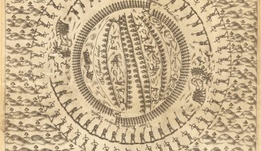
In 1532, Munster contributed notes on the construction of a map of the world to Johann Huttich’s Novus Orbis Regionum (Basle, 1532), and for this reason the accompanying world map is credited to him. An interesting decorative feature of the map is the two cherubs at the North and South Poles rotating the World on its axis.
Two woodcut maps of the northern and southern celestial hemispheres cut by Johann Honter, who was living in Basle, date from the same period. The southern hemisphere bears Honter’s initials ‘IHC’ (Johannes Honterus Coronensis), and the northern hemisphere the date 1532. While it is unclear what role Munster may have played in the preparation of these two celestials, they were subsequently published in the edition of Ptolemy’s Almagest printed by Heinrich Petri in 1541, undoubtedly with Munster’s involvement. The Almagest can sometimes be found bound with the 1540 edition of Ptolemy’s Geographia, also printed by Petri, as the example in the British Library, for example.
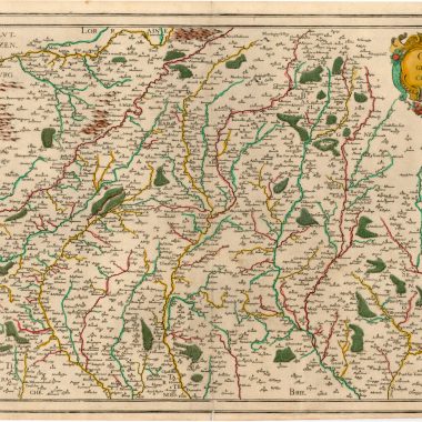
In the next few years, Munster produced the most important maps to bear his imprint. In 1536 appeared his Mappa Evropae… with three small woodcut maps, a map of Europe, a map of the Rhine, and a re-issue of his map of the environs of Heidelberg, again a revision of his material on Germany, but now extended to cover all of Europe.
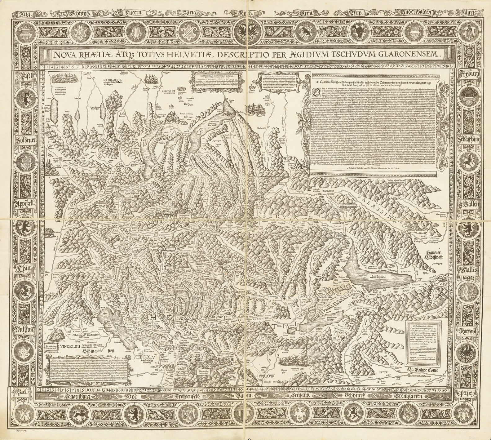
In 1537, Munster published a map of the Hegau region, from the Black Forest, taken from an original survey that he made, set within a broadsheet. Then in 1538, he published what is probably the most significant of his cartographic production, Aegidius Tschudi’s nine sheet map of Switzerland, again with an accompanying booklet. Tschudi seems to have been a perfectionist, unwilling to countenance publication until his work was “complete”. The act of publication seems to have caused a bitter rift between Tschudi and Munster, although Munster seems to have been the innocent party (a fuller version of the story is told by Karrow).
Also in 1538, Munster published his Die Löblich Vnd Wyt Berümpt Stat Basel Mit Vmbligender Landtscafft Nach Warer Geographischer…, a broadsheet publication comprising two maps on one sheet: the environs of Basle and a plan of the city.
All these broadsheet maps are rare. Unfortunately, Tschudi’s map of Switzerland, for example, is known only by a later printing of 1560.
Having thus established himself as the leading German geographer of his generation, it seems unfortunate that Munster turned his attention to editing two classical texts, for which he prepared a series of maps. The first was an edition of Solinus’s Polyhistor, Rerum Toto Orbe Memorabilium Thesaurus Locupletissimus, which contains an undistinguished group of maps.
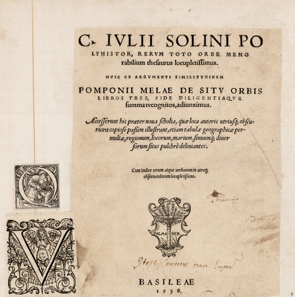
However undistinguished the group map be, individual maps have their own claim to fame. The book contains the first printed map of Asia as a whole, the first map to show the north-west coast of America (appearing on the map of Asia), and the first modern map of Moscovy, taken from a manuscript map by Matthias of Michov.
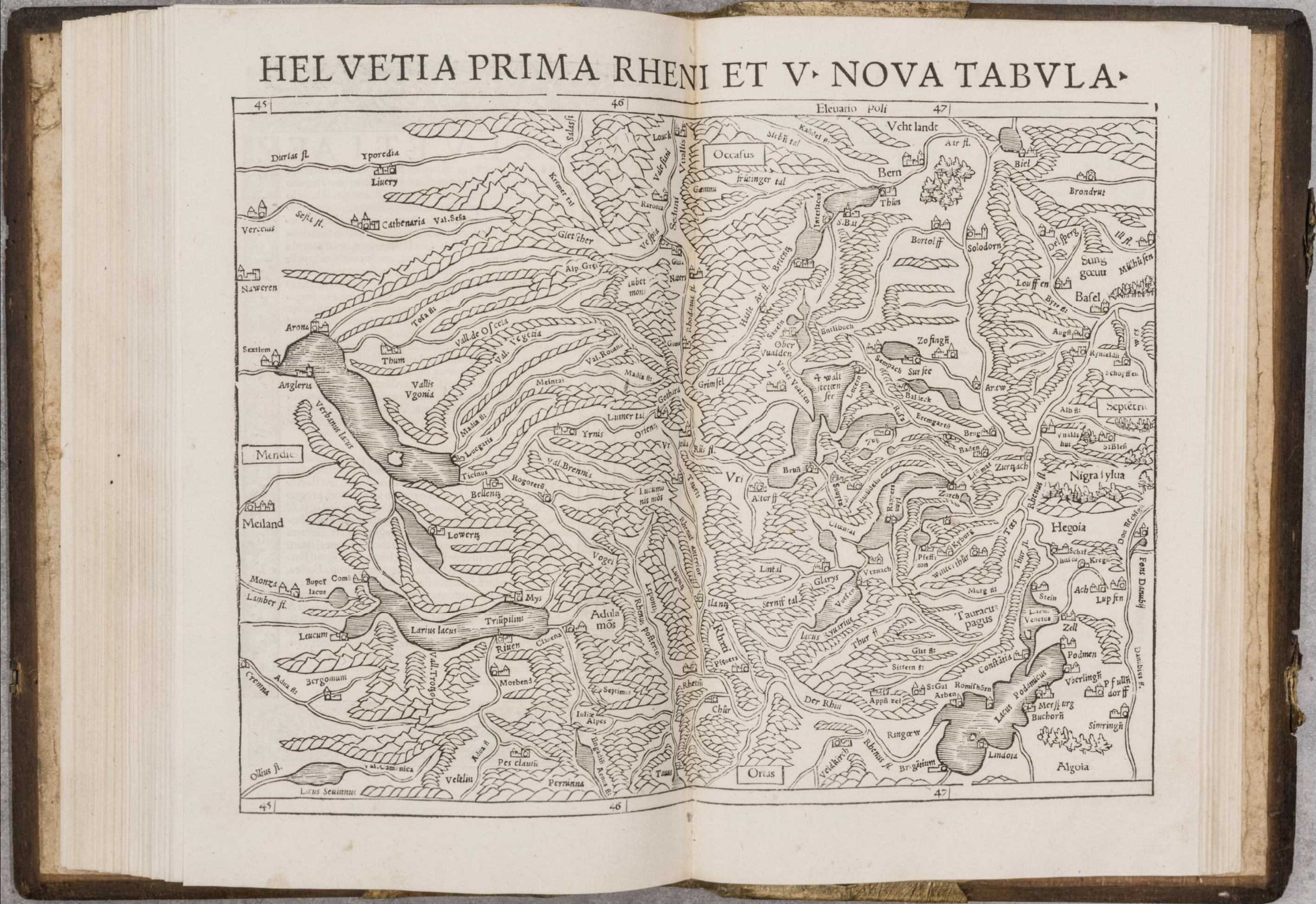
In 1540, Munster’s edition of Ptolemy appeared, illustrated with 48 woodcut maps, the standard Ptolemaic corpus supplemented by a number of new maps, of great significance for the mapping of Europe. Martin Waldseemuller’s edition of 1513 contained modern maps of the countries of Europe to contrast with the Ptolemaic versions, but also three new regional maps: Switzerland, the Rhine and Lotharingia (Lorraine). Munster’s edition contained several new maps of the regions of Germany and the Low Countries.
It is probably impossible to exaggerate the influence that these maps, his published texts and broadsheet maps had on his successors. Essentially, Munster laid down a challenge: “here is what I know, do you know better?” While a small number of regional maps had been published in the sixteenth century, no-one had undertaken a program of publishing such maps. The thriving regional cartography evident in Germany over the next generation must owe a great deal to this challenge, and the way the subsequent generation responded to it.
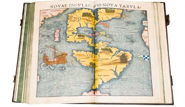
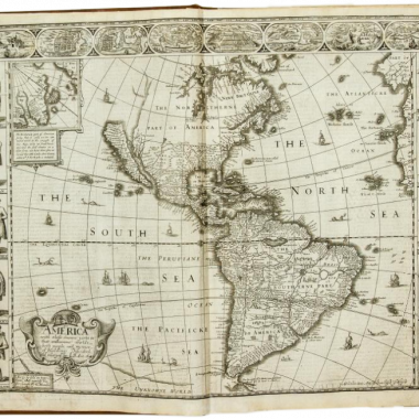
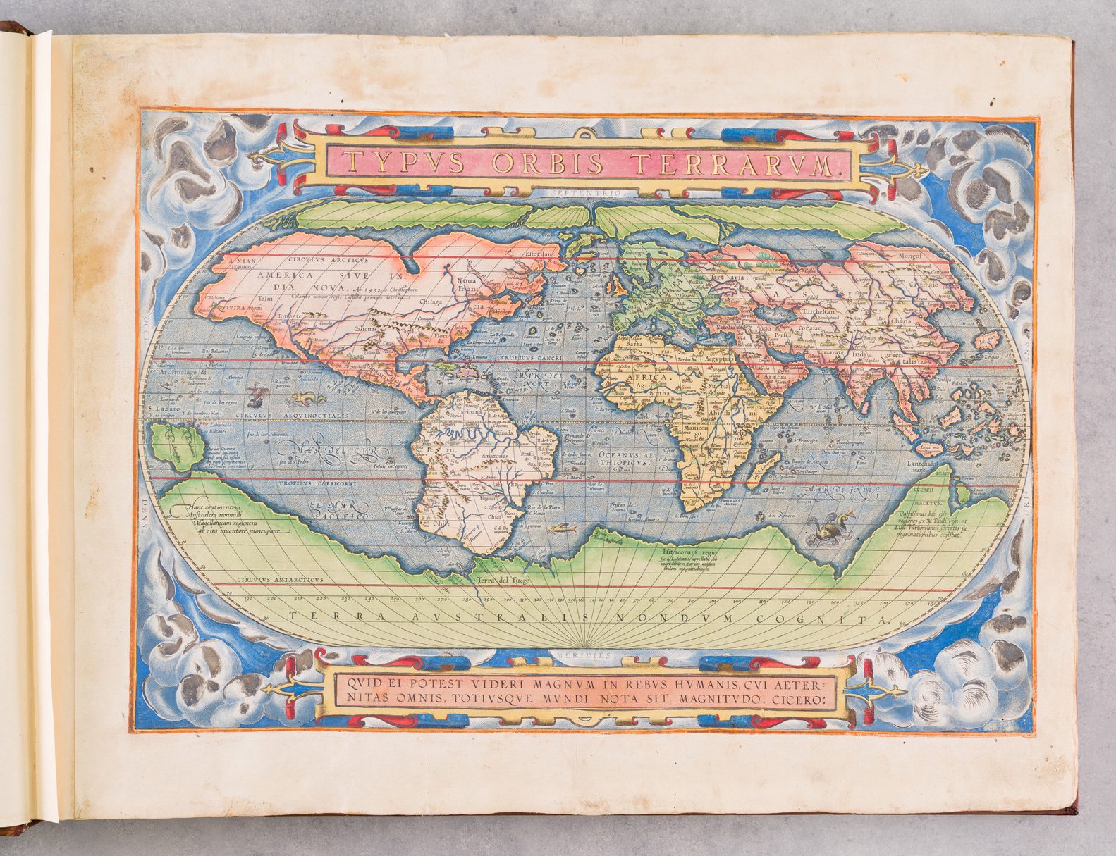
Greater publicity has been given to his maps of the four continents. While individual continents had been mapped as entities, in print, before 1540 (Europe by Waldseemuller, 1511; Africa in Montalboddo’s ‘Itinerariu[m] Portugallesiu[m]‘, 1508; Asia in Munster’s edition of Solinus, 1538, America by Stobniza, 1512), Munster was the first to publish a set of maps of the four Continents.
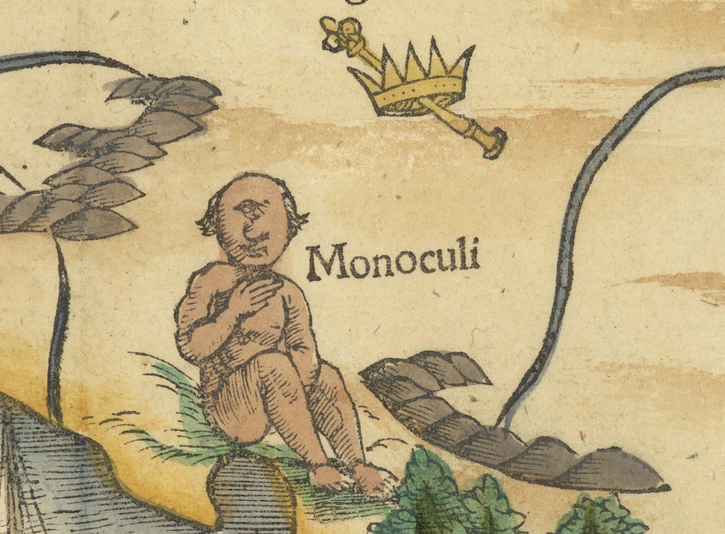
The maps are also famous for their decorative elements – Magellan’s ship the ‘Victoria’ is prominent on the map of the Americas, the ‘monoculi’ (or cyclops) on the map of Africa, the shipwreck of St. Paul on the second map of Africa, and the drawing of the elephant on the map of Ceylon. Also, the map of Europe is unusual (by modern standards) as being printed with south at the top of the page.
The maps in the ‘Geographia‘ were woodcuts, with type inserts making up the titles outside the upper border, many place names, and the descriptive text found in panels on some of the maps. The Americas, for example has been found in thirteen different states of the map, and that without including variations in the title outside the upper border.
There were four editions of the ‘Geographia‘ with Munster’s maps: 1540, 1542, 1545 and 1552. Some authors refer to editions of 1541 and 1551 (for example Ruland), but these seem to be ghosts (4). Nonetheless, it is clear that Munster’s editions were very popular, achieved wide distribution, and also widespread influence. For example, Munster’s maps provided the basis for the maps in the 1548 Venice edition of Ptolemy, Ptolemeo. La Geografia Di Clavdio Ptolemeo … Con Le Tauole … Di Meser Iacopo Gastaldo Piamo[n]tese Cosmographo..., edited by Pietro Andrea Mattioli, with the maps supplied by Giacomo Gastaldi. Gastaldi’s maps, in turn, were copied for the 1561 Venice edition, edited by Girolamo Ruscelli, which was reprinted as late as 1599.
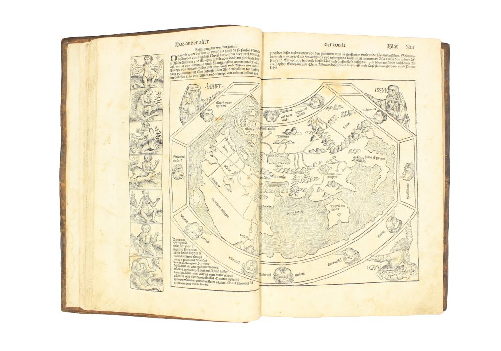
Having completed the Geographia, Munster returned to his pet project, the description of Germany. In 1544, he published the first edition of the Cosmographia, a summary both of Munster’s own geographical researches and those of his many correspondents. The Cosmographia, with its later expanded editions, was as close as Munster would come to fulfilling the vision of 1528.
The Cosmographia was very much in the illustrative tradition of the Hartmann Schgedel’s Nuremberg Chronicle, bringing together many of the modern maps from the Geographia, additional maps that had come to him in the intervening years, as well as several hundred woodcuts printed set in the text. Again, the Cosmographia was frequently reprinted. For the 1550 edition additions included a large number of town prospects. Seen as a volume, it is impressive testimony to one’s man’s vision and effort.
The 1550 edition of the Cosmographia was the final flowering of Munster’s work. Both the Geographia and Cosmographia were reprinted in 1552, but they had taken on their final shape. In the middle of 1550, on 26th May, Munster died of plague, bringing to the end the career of this gifted and energetic geographer.
That was not to be the end of his influence, however. Heinrich Petri, his successor continued to publish new edition of the Cosmographia, as did Heinrich’s son Sebastian Henri Petri. Munster’s text was much reprinted by other publishers, most notably by François de Belleforest, although the maps and plans used to illustrate this edition were taken from more modern sources – Abraham Ortelius’s Theatrum Orbis Terrarum (1570), and Braun and Hogenberg’s Civitates Orbis Terrarum, published from 1572 onwards. Indeed, for the 1588 edition of the Cosmographia, Sebastian Henricpetri substituted new maps taken from Ortelius, but using woodcuts cut in emulation of the copperplate style of Ortelius’s maps.
Notes
(1) This account depends heavily on R.A. Skelton’s introduction to the facsimile of the 1540 Basle Ptolemy, (Amsterdam: Theatrum Orbis Terrarum Press, 1966), and more particularly Robert W. Karrow Jr’s Mapmakers of the Sixteenth Century and their Maps, (Chicago, Speculum Orbis Press, 1993), which gives a much fuller account of Munster’s activities and publications.
(2) The text (quoted in full by Karrow, p.413-4) reads:
“It is plain and obvious that the maps of Germany which have been appearing of late have been drawn with erroneous longitudes, as is clearly indicated by the wide arc which they attribute to the Rhine between Strassburg and Mainz, not at all like the actual course of the river as I have observed it. One map maker copies the other, right or wrong. It is true that it would be too heavy and costly a burden for one man to observe and describe Germany properly. … Notwithstanding this difficulty, we must seek support in our plan to describe Germany’s territories, cities, towns, villages, distinguished castles and monasteries, its mountains, forests, rivers, lakes, and its products, as well as the characteristics and customs of its people, the noteworthy events that have happened, and the antiquities which are still found in many places. I shall now begin this undertaking, hoping that many of you will come to my assistance … Now, I think we should attack the project in this way: Herr Konrad Peutinger shall be responsible for the description of Augsburg and surroundings to a distance of six to eight miles from the city. Johann Aventinus shall undertake to describe Regensburg or Landshut and their environs in a circumference of as many miles … And all others do likewise and send the descriptions on to me or to Jakob Kobel, municipal secretary at Oppenheim. I shall gather them all together and have them printed; then we shall see what kind of a land our ancestors conquered for their home: not a crude, uncivilized country but a paradise and pleasure garden in which everything necessary to man’s happiness is found …”
(3) The map, and its very confusing history, are described in Tony Campbell, Earliest
Printed Maps (London: British Library, 1987), 4;
(4) H.L. Ruland, A Survey of the double-page Maps in thirty-five Editions of the Cosmographia Universalis, 1544-1628, of Sebastian Munster and his editions of Ptolemy’s Geographia, 1540-1552′, in Imago Mundi XVI (reprint edition, Amsterdam: Nico Israel, 19657), pp.84-97.