Among the more ephemeral items produced by mapsellers and publishers were engraved advertisement labels. Those that survive generally owe their survival to having been pasted to items sold by the shopkeeper in question.
One problem with cataloguing such labels is that they are frequently undated, so establishing a date has to be a process of deduction, based around the address given, the mapseller’s titles, royal or otherwise, and other biographical information present, for example if the item is signed by the engraver, although this later is itself an infrequent occurrence.
The two engraved advertisements featured were issued by the London mapmaker, map-seller and publisher, Thomas Jefferys Sr. Unfortunately, little is known about his early life, and the one frequently repeated “fact” is actually incorrect, thus introducing unfortunate confusion into the account – found for example in the entry for Jefferys in the revised edition of Tooley’s Dictionary Of Mapmakers (2).
This error can be traced back to Ida Darlington and James Howgego’s Printed Maps of London circa 1553-1850 (3), entries 33 (4) and 79 (2). Both entries refer to maps of London published by Jefferys, the first William Morgan’s plan of London bearing the dated 1732, and the second a plan dated 1735. In fact, it seems clear that both maps were issued dated thus by George Willdey, and that after Thomas Willdey’s death in 1748, the plates passed to Jefferys who re-issued them with the dates unchanged.
Then, by “establishing” 1732 as a start date for Jefferys’ career, a date of birth for Jefferys of ca. 1710 could be postulated.
Recent research by Laurence Worms (1) has helped to flesh out some of Jefferys’ early careeer, although many uncertainties remain. Worms believes that Jefferys was born in 1719, the son of Henry Jefferys, Cutler, of St. James Clerkenwell, although his place of birth is uncertain. Worms has also located his apprenticeship, in December 1735, to the engraver and mapmaker Emanuel Bowen.
Jefferys was freed from his apprenticeship in 1744. His “earliest” publication, that I know of, is John Doharty Jr.’s plan of Worcester, apparently published from Jefferys’ address at the corner of St Martins Lane in 1742. Unfortunately, this would again appear to be a re-issue of an existing map, retaining an old date, a curious omission. More reliably, Jefferys engraved some maps for Richard Pococke’s A Description Of The East, And Some Other Countries … (London: 1743-1745), for example the map of Cyprus in volume 2.
In 1746, Jefferys was appointed Geographer to Frederick, Prince of Wales, and in 1757, Geographer to George, Prince of Wales, later George III.
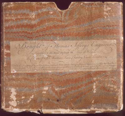
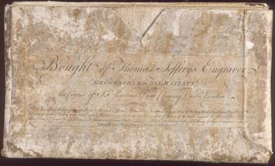
Both the advertisements described are printed from the same engraved plate, and both are undated. The text of both is transcribed at the end.
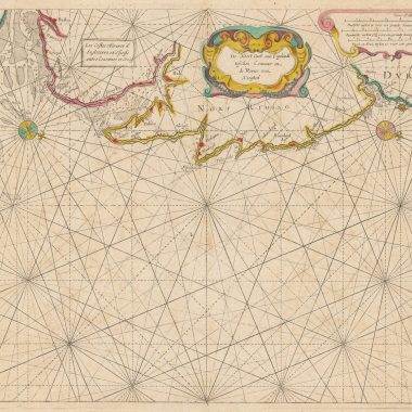
The earlier of the advertisement refers to Jefferys as Geographer to the Prince of Wales, so dates from 1746 onwards. The advertisement is pasted on an original slipcase, labelled in manuscript “SCOTLAND”, which now contains the single-sheet reduction of James Dorrett’s map of Scotland, dated 1751. (4) The map does not fit the slipcase, so it is more plausible that the slipcase originally contained Dorret’s wall-map, published the previous year. In view of the provenance of the map this is a possible explanation (see below).
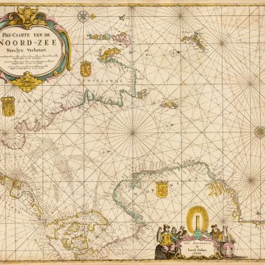
The second advertisement has been re-engraved, and refers to Jefferys as Geographer to the King, following the accession of George, Prince of Wales to the throne as George III in 1760. It is found on the slipcase of Jefferys’ map of Hesse-Cassel, dated 1760 (5).
It would be convenient to assume that the first advertisement dates from 1750 or 1751 and the second from 1760, as the dates on the maps. However, it should be borne in mind that the labels were printed separately from the maps, and then brought together at some point. Thus, the label could have been printed earlier than the accompanying map, if an existing printed label was applied when the map was new, or rather later if old stock of maps was being sold with a new label. A further problem is that the date on the maps need not accurately indicate the date of actual printing of the impression of the map in question, rather the first appearance of the map itself.
Both maps were acquired by the current owner at auction of property of the Percy family, of Alnwick Castle in Northumberland, so it is certainly plausible that the family acquired the maps close to the time of original publication.
It would seem possible that the first advertisement plate was prepared at about the time Jefferys moved to the St. Martin’s Lane address, circa 1749/1750 and that the second state was quickly prepared when Jefferys was confirmed as Geographer to the king in 1760.
If so, and this can be no more than supposition, the first label is the earliest Jefferys stock-list or advertisement, however brief, that I have encountered.
Thomas Jefferys’ trade-card, generally ascribed to circa 1750 or 1751 was described in MapForum issue 1.
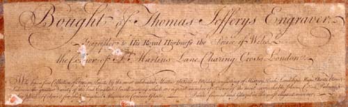
[Advertisement one]:
Bought of Thomas Jefferys Engraver,
Geographer to His Royal Highness the Prince of Wales, / the Corner of S.t Martins Lane Charing Cross London.
Who has a fine Collection of Foreign Prints by the most celebrated Masters, Antient or Modern, consisting of History, Heads, Landskips, Maps, Charts, Plans &c. / Likewise the greatest Variety of the best English Prints, among which are a great number of Views of the most remarkable Places, Cities, Palaces, &c. / Either plain or Colour’d for the Diagonal Mirrour or Concave Glass. ____ Prints framed and Glazed in the most elegant manner.
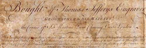
Advertisement 2:
Bought of Thomas Jefferys Engraver,
Geographer to His MAJESTY, / the Corner of S.t Martins Lane Charing Cross London.
Who has a fine Collection of Foreign Prints by the most celebrated Masters, Antient or Modern, consisting of History, Heads, Landskips, Maps, Charts, Plans &c. / Likewise the greatest Variety of the best English Prints, among which are a great number of Views of the most remarkable Places, Cities, Palaces, &c. / Either plain or Colour’d for the Diagonal Mirrour or Concave Glass. ____ Prints framed and Glazed in the most elegant manner. / Baskerville’s fine Writing Paper, & all sorts of Stationary &c.#
Notes:
(1). Laurence Worms, typescript notes. Worms has contributed the entry on Jefferys to the forthcoming edition of the Dictionary of National Biography, and I am grateful to him for his sight of his text, and accompanying notes.
(2). Tooley’s Dictionary Of Mapmakers Revised Edition E-J. Edited by Joseph French, Consulting Editors Valerie Scott, Mary Alice Lowenthal.(Riverside, Connecticut: Early World Press, 2001).
(3). James Howgego, Printed Maps of London circa 1553-1850. Second Edition. (Folkestone: Dawson, 1978)
(4). DORRET: A Correct MAP of SCOTLAND from new Surveys. / By James Dorrett, Land Surveyor. [2a-3a] J: Dorret delin: et Sculp. [1e, in border] Published April 30.th 1751. [5e, in border]
Copperplate engraving, 765 x 602mm.
(5) [Louis François Carlet de la Roziere] THE LANDGRAVIATE OF / HESSE CASSEL / with PART of / WETTERAVIA, / and the adjacent Countries: / Taken from a large Drawing, / found in the Cabinet of the LANDGRAVE of HESSE, / AND / Corrected from ACTUAL SURVEYS, Made by / M.r Carlet de la Roziere. / Captain of Dragoons, & Aid de Camp to Marshal Broglie, 1760. / LONDON: / Engraved & Published by Thomas Jefferys, Geographer to HIS MAJESTY. [5d] To the Right Honourable Charles Townshend, / His Majesty’s SECRETARY of War; / And one of his Majesty’s most Honourable Privy Council, / This Map is most Humbly Inscribed / By his most Obedient Humble Serv.t Tho.s Jefferys. [5e]
Copperplate engraving, 959 x 824mm, 4 sheets joined.