Library of Congress G1059. C64 1669 vault; Phillips 480
Collated by David Parry
The example described is in the library of
The Royal Geographical Society of South Australia Inc
State Library Building, North Terrace
Adelaide, South Australia 5000
The atlas, bound in vellum with gold leaf tooling, is in excellent condition, and contains a world map & sixteen charts, all undated.
| [Title] | ZEE – ATLAS / ofte / WATER-WERELDT. / In houdende een korte / BESCHRYVINGE /van alle de bekende / ZEE-KUSTEN / des / AARDTRYCKS, / Nieuwelijcks uyt-ghegheven, door /ARNOLD COLOM / AMSTERDAM, / opt Water, by de Nieuwen-brugh, inde / Lichtende Colom. |
| 1. | [Double Hemisphere World Map Title inside northern map border: NOVA DELINEATIO TOTIUS ORBIS TERRARUM AUCTORE A. COLOM Cartouche in Eastern hemisphere: WERELT CAARTE / nieuwlijx uijt gegevern / door/ARNOLD COLOM / Amsteldam op water inde Lichtende Colom. [without plate number] | 54.0 x 63.2cm |
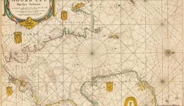
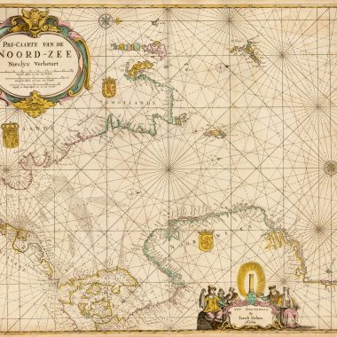
| 2. | Title Cartouche in North-west quadrant: Pascarte / Vande / NOORD ZEECartouche in South-east quadrant: Door / ARNOLD COLOM / tAmsterdam op het Watter /by de Nieuwe-brugh / inde / Lichtende ColomNumber 1 in bottom right-hand corner of plate just outside map border.[scales] Duytsche mylen 15 voor een graadt / Spaensche mylen 17½ voor een graadt / Engels en Frans. mylen 20 voor een graadt | Orientation: North to the East54.0 x 64.0cm |
| 3. | Title Cartouche in North-west quadrant: OOST ZEE / door /Arnold Colom / op het Water by de Nieuwe brugh / inde / Lichtende Colom.In South-east quadrant an inset map of OOST FINLANDT & RUSLAND with a cherub and putti cartouche. Inset map measures 14.1 x 11.0 cmNumber 2 in bottom right-hand corner of plate just outside map border.[scales] Duytsche mylen 15 voor een graadt / Spaensche mylen 17½ voor een graadt / Engels en Fransche. mylen 20 voor een graadt | Two blank armorial bearings below crowns above OOST ZEE.Orientation: North at top54.4 x 63.6 cm |
| 4. | Title Cartouche in North-east quadrant: De Sondt en Belt uyt gegeven / door Arnold Colom op/het water Inset view of “COPPENHAVEN” in upper middle of right-hand sheet within a cartouche bordered by fruits – oranges, apples pears and leaves. View of Coppenhaven scrolled at the edges and measures 8.3 x 14.0 cm. Number 3 in bottom right-hand corner of plate just outside map border.[scales] Duytsche mylen 15 voor een graadt/Spaenssche mylen 17½ voor een graadt/Engels en Franf. mylen 20 voor een graadt | Orientation: North to the West55.0 x 62.8 cm |
| 5. | Title Cartouche in South-east quadrant of the left-hand page: Nieuwe Pascaart / door / ARNOLD COLOM / tAmsterdam op het Water by de Nieuwe Brugh / inde / Lichtende Colom.Number 4 in bottom right-hand corner of plate just outside map border.[scales] Duytsche mylen 15 voor een graadt / Spaenssche mylen 17½ voor een graadt / Eng. en Franf. mylen 20 voor een graadtInset of “Ian Mayen Eylant” in south-west quadrant measuring 7.9 x 15.1 cm with an engraving of the Ice Mountain. | Chart shows ‘YSLAND, N. SCOTLAND, FINMAKKEN, LAPLAND & NOVA ZEMLA’Empty armorial bearings with crown above cartouche.Orientation: North to the North-east.54.5 x 63.8 cm |
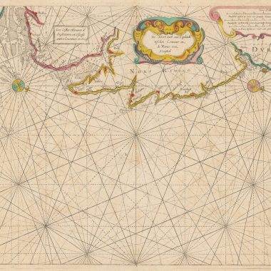
| 6. | Title Cartouche in South-east quadrant: Pascaarte / vant / CANAAL / door / ARNOLD COLOM / tAmsterdam op het Water by de / Nieuwe brugh / inde / LICHTENDE COLOM.Number 5 in bottom right-hand corner of plate just outside map border.[scales] Duytsche mylen 15 voor een graadt / Spaenssche mylen 17½ voor een graadt / Eng. en Franf. mylen 20 voor een graadt | The chart shows the British Isles and French coast with the armorial bearings of France, England, Scotland and Ireland.Orientation: North to the East |
| 7. | Title Cartouche upper middle of right-hand sheet: Pascaarte / van / HISPANGIEN / van de / Noord zyde van Yrlandt / tot / de Straet.Second Cartouche in North-west quadrant: Door / ARNOLD COLOM / tAmsterdam op het Water / by de Nieuwe brugh / inde / Lichtende ColomNo chart number on plate[scales] Duytsche mylen 15 voor een graadt / Spaenssche mylen 17½ voor een graadt / Engels en Franf. mylen 20 voor een graadt | Orientation: North to the West53.3 x 63.7 cm |
| 8. | Title Cartouche in South-east quadrant: Middel landtsche Zee / Nieuwelix uytgegeven / door / ARNOLD COLOM. / op het Water by be Nieuwe brugh / inde / Lichtende Colom / tot / Amsterdam.Number 7 in bottom right-hand corner of plate just outside map border.[scale in the middle of chart above the southern border of the Western Mediterranean chart] Duytsche mylen 15 voor een graadt/Spaensche mylen 17½ voor een graadt /Engelsche en Fransche mylen 20 voor een graadtSecond scale bar in North-west quadrant [table of island names, harbours and havens in the Western Mediterranean] “Namen van d’Eylanden, Hoeken en Havens, geleegen in t Weste:/lycke – deel – der Middelandtse Zee.” 8.5 x 13.6 cm[table of island names, harbours and havens in the Eastern Mediterranean] ‘Namen der Eylanden en voorn & amste Hoecken geleegen in dit On: /derste, Zynde t Ooste lycke van de Middelandtsche-Zee”. 97 islands named. 8.7 x 15.3 cm | The chart shows the Western Mediterranean in the top half of the chart and the Eastern Mediterranean in the bottom half. Orientation: North at the top52.9 x 62.6 cm |
| 9. | Title Cartouche in North-east quadrant: de / Vlaamsche / en / Canarische / Eylanden / door / Arnold Colom. / tot Amsterdam /op de Texelsche /kay / inde Lichtende / ColomNumber 8 in bottom right-hand corner of plate just outside map border. | Orientation: North to the West53.8 x 63.0 cm |
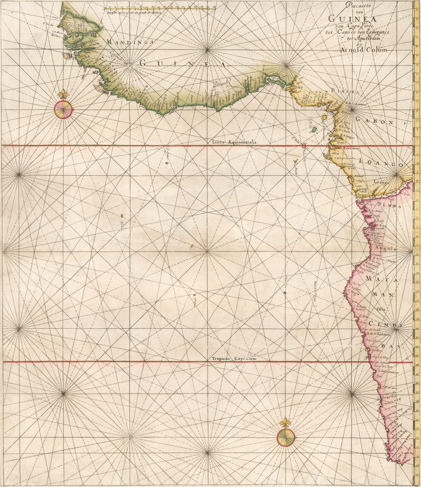
| 10. | No title Cartouche; the title is written in the North-west quadrant over rhumb lines: Pascaarte /van / GUINEA / van Capo Verde / tot Capo bon Esperance / tot Amsterdam / by / Arnold ColomNumber 9 in bottom right-hand corner of plate just outside map border.One scale bar in Duytsche mylen along Western boundary of chart. | Orientation: North to the West55.2 x 64.0 cm |
| 11. | Title Cartouche in South-west quadrant: OOST INDIEN / Van Cabo de Bona / Esperanca / tot / Ceilon / Uyt gegeeven door / ARNOLD COLOM / tot Amsterdam op het Water inde Lichtende ColomNumber 10 in bottom right-hand corner of plate just outside map border.Scale Bars in North-east quadrant: Duytsche mylen 15 voor een graadt / Spaensche mylen 17½ voor een graadt / Engels: en Frans mylen 20 voor een graadt | Orientation: North to the West53.5 x 63.0 cm |
| 12. | Title Cartouche in North-east Quadrant on its side because of map orientation with North to the West: Oosterdeel van / OOST INDIEN / door / Arnold Colom. / tot Amsterdam inde Lichtende Colom.Number 11 just visible in bottom right-hand corner outside the map boundary.Scale bars above cartouche: Duytsche mylen 15 voor een graadt / Spaensche mylen 17½ voor een graadt / Eng. en Frans mylen 20 voor een graadt | Orientation: North to the West54.7 x 64.0 cm |
| 13. | Title Cartouche in South-east quadrant: Pascaarte / van Brazil en / Nieu Nederlandt / van cuorvo en Flores / tot de Barbados / nu eerst uyt gegeeven / door / Arnold Colom / tot / Amsterdam / op t Water by de / Nieuwe brugh / inde / lichtende / Colom.Number 12 in bottom right-hand corner of plate just outside map border.Scale bars mid-bottom of left-hand page: Duytsche mylen 15 voor een graadt / Spaensche mylen 17½ voor een graadt / Eng. en Frans mylen 20 voor een graadt | Orientation: North to the West55.1 x 64.0 cm |
| 14. | Title Cartouche upper-middle on right-hand page: Zuyder deel / van / AMERICA / uyt gegeeven door / Arnold Colom.Inset map of Nicaraguan coast on left page in Brazil with title Vervattinge / van Manta / to R. Verde.’Number 13 in bottom right-hand corner of plate just outside map border.Scale bars in South-east quadrant: Duytsche mylen 15 voor een graadt / Spaensche mylen 17½ voor een graadt / Engel en Frans mylen 20 voor een graadt | Orientation: North at the top54.2 x 63.0 cm |
| 15. | Title Cartouche in North-west quadrant: De / CARYBSCHE EYLANDEN / van de barbados tot de / bocht van Mexico toe / nu eerst Uyt gegeeven door / Arnold Colom / tot Amsterdam / op het Water by de Nieuwe brugh/in de Lichtende Colom.Number 14 in bottom right-hand corner of plate just outside map border.Scale bars in South-west quadrant: Duytsche mylen 15 voor een graadt / Spaensche mylen 17½ voor een graadt / Eng. en Frans mylen 20 voor een graadt | Orientation: North at the top54.4 x 64.0 cm |
| 16. | Title Cartouche in North-east quadrant below scale bars in Dutch and English: NIEUWE CARYBSCHE PASCAART / The Carybes Ilands / Newly Setforth and amendid / by Arnold Colom / Amsterdam dwelling on the Water in the Lightning ColomSecond Title Cartouche in Dutch in North-west quadrant: Pascaarte / Nieuwelyx uyt gegeeven / door / ARNOLD COLOM / tot / Amsterdam / op het Water by de Nieuwe brugh / inde / lichtende Colom.Number 15 in bottom right-hand corner of plate just outside map border.Scale bars above: Duytsche mylen 15 voor een graadt / Spaensche mylen 17½ voor een graadt / Eng. en Fra. mylen 20 voor een graadt | Orientation: North to the South54.2 x 64.0 cm |
| 17. | [Virginia and New England] Title Cartouche in the North-west quadrant: Pascaarte / van / NIEU NEDERLANDT / uyt gegeeven / door / Arnold Colom. / t Amsterdam / opt Water by de Nieuwe brugh inde Lichtende / Colom.Number 16 in bottom right-hand corner of plate just outside map border.[scale bars in North-east quadrant] Duytsche mylen 15 voor een graadt / Spaensche mylen 17½ voor een graadt / Engels en Franse mylen 20 voor een graadt | Orientation: North at the top54.6 x 64.0 cm. |