The Beginner’s Guide will be a series of general articles intended to introduce the world of antique maps. To start we described the power of maps over men. Subsequent articles will:
- describe the processes and techniques by which they were created, printed and distributed
- explain the terminology used to describe the elements of a map
- provide pointers for the collector on topics such as colour and condition
- explain what to look for in an original; and how to identify facsimiles and fakes.
The Joy of Maps
In 1570, the English mathematician and map-maker, John Dee, wrote:
Some, to beautify their Halls, Parlers, Chambers, Galeries, Studies or Libraries with… [Collectors] liketh, loveth, getteth, and useth, Maps, Charts, and Geographical Globes…
Maps have always an immediate visual appeal, whether in the more elaborately engraved, highly decorative style so much loved by early map-makers and publishers, or the elegant simplicity, but high technical accuracy, of the modern map.
R.A. Skelton, writing in 1965, commented “That maps should please the eye has been accepted even by scientific cartographers. A map, remarked the French military engineer [Rigobert] Bonne about 1800, is so “dry” an object that opportunities for treating it as a picture must not be lost”. 1
Many writers have tried to explain the appeal of maps. The seventeenth-century Spanish author Miguel Cervantes Saavedra wrote that by simply looking at a map one could:
journey all over the universe in a map, without the expense and fatigue of travelling, without suffering the inconvenience of cold, hunger and thirst…
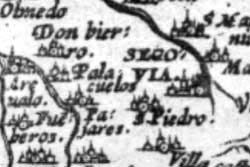
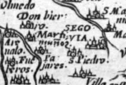
Another aspect is the immediate desire of the viewer to look for familiar places or landmarks in the map before them. However, on one occasion at least, this tendency rebounded on the publisher concerned. In 1570, the Flemish map-maker Abraham Ortelius despatched a presentation copy of his atlas, the Theatrum Orbis Terrarum, to his royal master, Philip II of Spain. When the messenger arrived at Philip’s palace, Philip was away, so the gift was received by Cardinal Espinosa. The Cardinal opened the atlas, turned to the map of Spain, and looked for his birth-place Martimuñoz to find, to his chagrin, that it was not marked. This was probably not an unusual occurrence on maps of the period, but Espinosa was of sufficient status to do something about it. Ortelius subsequently received a letter from an official in Brussels.
Cardinal [Espinosa] writes me from Spain that he regrets to find his native town Martimuñoz, omitted in the map in your �Theatrum� and asks me to send him a coloured copy of it with the said name inserted. Therefore remove, if possible, the name of Palacuelos and insert Martimuñoz in its place. When this is done let some copies of the map of Spain be printed to satisfy the wish of the Cardinal …
Amidst profuse apologies from Ortelius, the plate was reworked, Martimuñoz inserted, and a copy of the atlas set to the Cardinal.
To look at an old map is also to see the World, or one of its parts, as it would have been seen by the kings, aristocracy, government, the military, merchants and navigators of the day, or to stand at the shoulder of the writer Jonathan Swift, studying John Seller’s chart of the North Atlantic, as he penned the quatrain:
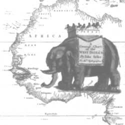
With Savage-Pictures fill their Gaps;
And o’er uninhabitable Downs
Place Elephants forwant of Towns”
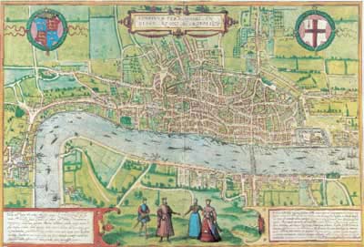
It is to step into the past to see countries, places and people as they once were – as this plan of London from the 1570’s exempilifies. The Cities of London and Westminster are connected only by a single road – the Strand, while world-famous parts of modern London, such as the West End (Regent Street, Oxford Street, Knightsbridge, etc) are still fields to the left of the map.
Maps above all tell of man’s strivings, the quest to see what is on the “other side of the hill”, across the river, or over the sea, and then his desire to record where the traveller had been and what he had seen.
Maps are the visual record the story of European expansion, firstly within domestic borders, and then into the tentative beginnings of the early colonial period, for example Henry Briggs’ map marking the English settlements of ‘James Citie’ (Virginia) and ‘Plymouth’ (Massachusetts), but without any real sense of the interior – the Great Lakes for example, and prominently displaying the contemporary conception that California was an island. At the other end of the spectrum John Young’s map of Texas, during its short-lived period as a republic, displays the expanding settlement pattern, as new counties are laid out to accommodate immigrants to the area.
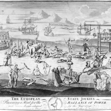
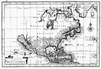
Just as one can pleasure in the accuracy, so too there can be pleasure in the inaccuracy – towns wrongly sited, coastlines wrongly charted, and rivers wrongly routed – and in the anachronisms, the travellers’ tales and fables adopted as fact by gullible mapmakers – the sea-monsters that inhabit many early charts, or the fanciful mediaeval creatures and distorted images of more factual animals, that populate the empty areas of maps of far flung areas outside European experience.
Then there are the misconceptions – California as an island (this example by Goos, 1624); the fictitious islands of Brasil and Frisland; , the legendary Seven Cities of Cibola, in the unsuccessful quest for which Spanish Conquistadores expended so much blood and sweat; and Raleigh’s mythical lake Parime, with the city of Manoa, the site of El Dorado.
It is all these things, and many more, that make maps such a popular collectable, but perhaps the most intriguing element of this is the diversity of delights that different viewers can find in a single image.
Notes
1. R.A. Skelton, ‘Decorative Printed Maps’, (London, Spring Books, 1965), p.16