One of the principal impetuses in the advancement of cartography is war. Wars require new survey work, to map terrain, delineate routes of march, and lay out and describe fortifications. These new surveys then need to be duplicated so that the information is readily available for the army to use, and so that, through their use, the detail can be revised and corrected. In the same way, wars also stimulate interest in the home-based citizenry for maps as a pictorial extension of the accounts carried in the papers of the day, to illustrate the lines of march, the phases of a battle, or conduct of a siege.
The American Revolutionary War proved to be no different. British map-publishers, who were starting to achieve ascendancy over other map-making nations, eagerly published maps of the battles and campaigns of the war, in face of a voracious public demand, and their French competitors soon entered the market, following France’s entry into the war. Kenneth Nebenzahl records 216 printed battle plans, published between 1775 and 1795.
While one might have thought that the surrender of the British Army at Yorktown would have prompted a huge upsurge in maps of the United States, it was not until 1783, closely following on from the signing of the Preliminary Treaty of Peace on January 20th that this increase can be seen.
It should be noted, however, that the approach of many mapmakers to the new nation was symbolic, rather than original, as the demands of depicting a new country are not quite the same as waging a war. In many cases, existing copperplates were pressed into service, with their titles altered, and the new nation’s boundaries inserted. This is particularly the case for some of the earliest English maps. Many subsequent European mapmakers felt justified in copying these early prototypes, or failed to see the commercial viability of producing original material, so little that was original emerged until nearly the end of the century.
For original mapmaking, one has to look to the Americans themselves. For a long time, access to British publishers had served to suppress a domestic publishing industry for maps, and in the years following the end of the Revolutionary War, Americans took their first hesitant steps towards cartographic independence, with a number of fine large-scale maps of the United States, by Abel Buell, William McMurray, and Abraham Bradley Jr, for example.
There has always been a tremendous cachet attached to the first map to refer to the United States in the title, and this discussion has been somewhat confused by the different terminology the Americans used to describe themselves. The Declaration of Independence, signed on July 4th 1776, was headed “The Unanimous Declaration of the Thirteen United States of America” while also, later in the text, referring to the “United Colonies.” In the Articles of Confederation, signed in late 1777, the name “The United States of America” was adopted for the new republic.
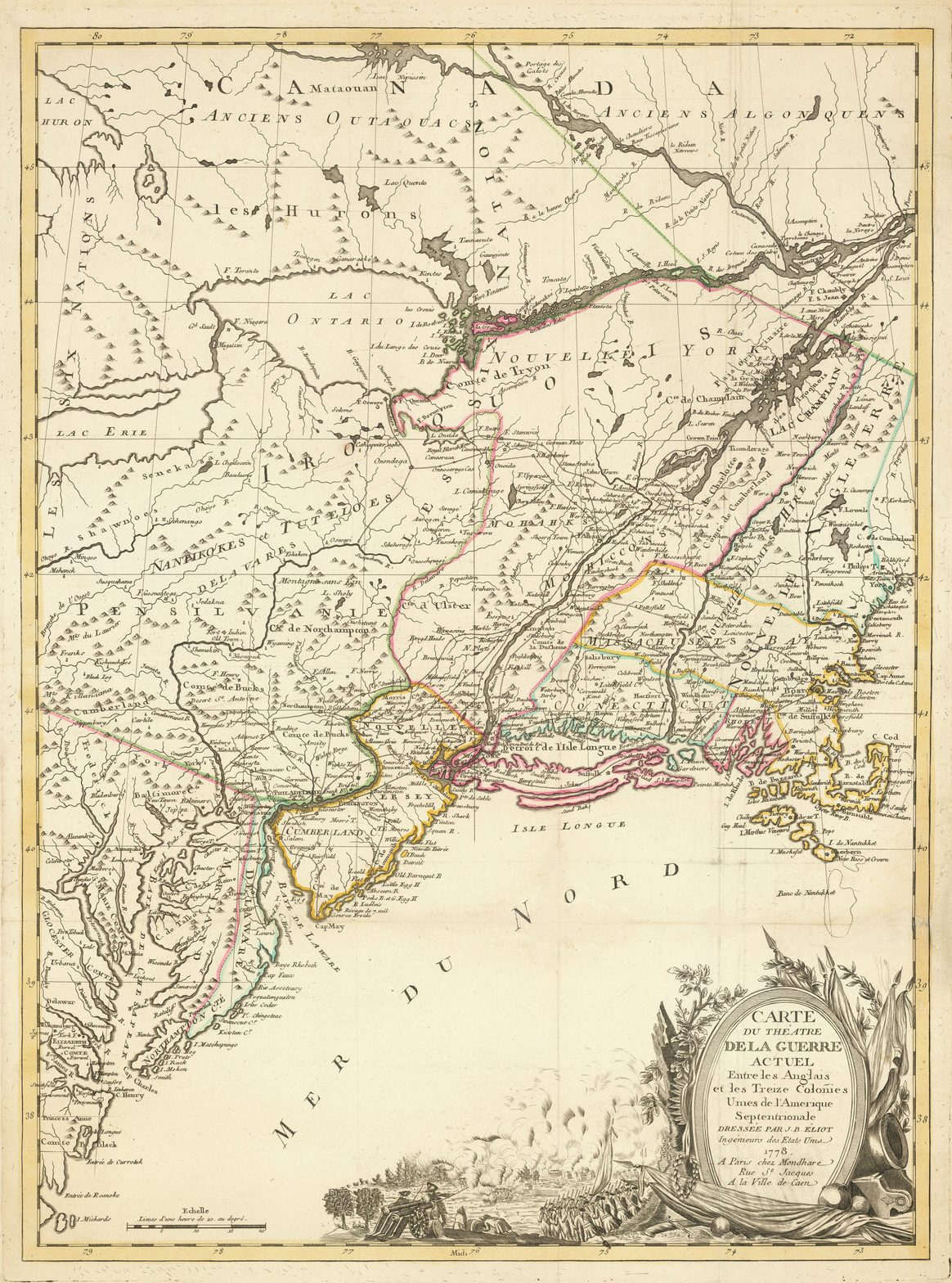
In 1778, two maps were published in France, referring to the “United States” in the title [maps A & B]. Until relatively recently, the Eliot map has been described as “the earliest to include in its title les Treize Colonies Unies de l’Amerique …, thus claiming priority in the naming of the new nation, in its French translation …”

In an article published in 1993 , in expanding a point made by Mary Pedley, Tim Coss argued that another map, first published by Didier Robert de Vaugondy in 1755, and re-published by Jean-Baptiste Fortin, in 1778, should claim precedence. He wrote:
With the emergence of the 1778 Vaugondy/Fortin map, the Eliot map can no longer claim sole possession of the ‘firsts’ previously attributed to it. And it could never have been considered the first map of the United States, with its title in transitional stage between British Colonies and United States (Colonies Unies)
This distinction, in my opinion, belongs to the Vaugondy/Fortin map. Its title is unambiguous, the area it coves includes a large portion of the territory of the original thirteen States, and no other map with these qualifications is dated as early as 1778 …
Despite Coss’ arguments, I have little doubt that the Eliot map comes first in chronological sequence. It would seem that the map was, at least in part, constructed in the Americas, if Eliot’s claim to be Ingénieur des Etats Unis is true, at a time when the two versions “United Colonies” and “United States” were in parallel use, both denoting an independent political entity separate from the British, while reflecting uncertainty about the name for the new republic. The Robert de Vaugondy/Fortin map seems to be a later form, re-engraved after the name “United States” was officially adopted, presumably when that news arrived in France.
Furthermore, the Eliot map seems to have captured popular imagination, in a way that the Robert de Vaugondy map does not. While a proper census of copies of the Eliot has never been attempted, it is clear that it survives in rather more examples than people think. Three examples have passed through London within the last two years, that I know of. The Robert de Vaugondy, on the other hand, does seem rather rarer, perhaps reflecting its size, and attendant risk of loss through damage, but also perhaps that the simple change of title did not generate appreciable renewed demand for the map.
In any case, neither map is a map of the United States, in a geographical sense; the Eliot is principally a map of New England, and omits much of the Middle States, and all the Southern States, while the Robert deVaugondy omits the Southern States.
So far as I am aware, the first printed map devoted to the thirteen states, and to use the a name distinguishing them from their previous status of British Colonies was published neither by an Englishman, Frenchman or American, but by an Italian, Antonio Zatta. His map, Le Colonie Unite Dell’America Settentrle ... was published in 1778, in his Storia Dell’America Settentrional, and then re-issued in the Atlante Novissimo (1778-1785). While (in relative terms) a common map, I do not know that anyone has previously remarked on the significance of the title.
The map is an Italian edition of John Mitchell’s landmark map of The British And French Dominions in North America …, first published in 1755; Zatta’s version, engraved in 1778, includes a small number of notes relating to events in the Revolutionary War, but is otherwise a close copy of Mitchell’s original.
The first map, that I have located, devoted to the thirteen states, that uses the name United States (in its French form) in the title is Rigobert Bonne’s map of July 1781.
The following list is a check-list of maps devoted to the United States, that is the region bounded by Florida in the south, the Mississippi in the West and Britain’s Canadian possessions in the North, published up to 1800. Omitted are maps of larger areas, such as of North America, the Western Hemisphere, and of the World as a whole.
| 1. Eliot, J.B. [Éliot] CARTE / DU THÉATRE / DE LA GUERRE / ACTUEL / Entre les Anglais / et les Treize Colonies / Unies de l’Amerique / Septentrionale / DRESSÉE PAR J.B. ÉLIOT, / Ingénieurs des Etats Unis / 1778. / A Paris chez Mondhare / Rue St. Jacques / A la Ville de Caen. [5e] 700 x 520mm. Separate publication, 1778 | 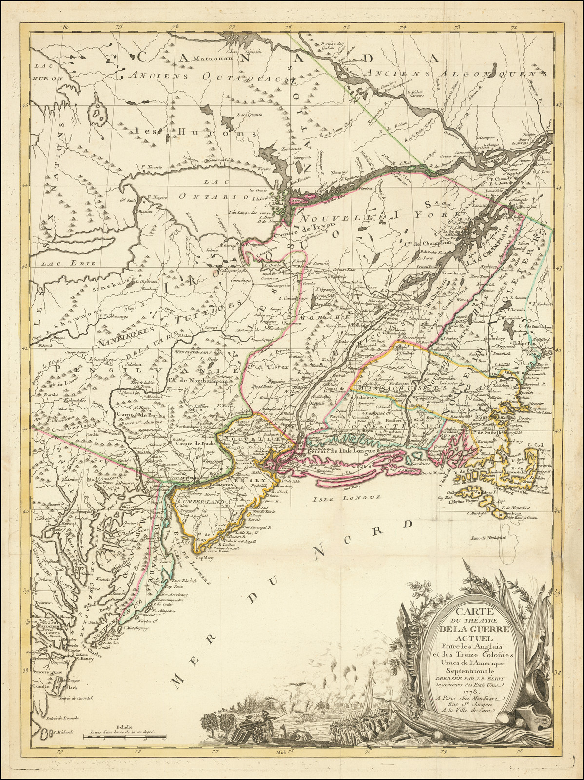 |
| 2. Eliot, J.B. [Éliot] CARTE / DU THÉATRE / DE LA GUERRE / ACTUEL / Entre les Anglais / et les Treize Colonies / Unies de l’Amerique / Septentrionale / DRESSÉE PAR J.B. ÉLIOT, / Aide De Camp Du Général Washington, Ou Se Trouvent Les Principaux Camps Et Les Epoques Des Combats Qui Se Sont Données Dans Cette Partie De L’Amerique 1781. [5e] 700 x 520mm. Separate publication, 1781 | The map has been revised to show events from the war, with a list of battles, thus. Ristow, p.62. |
| 3. Eliot, J.B. [Éliot] Carte du Theatre De La Guerre Actuel Entre Les Anglais Et Les Treize Colonies Unies De L’Amerique Septentrionale, Dressée Par J.B. Eliot, Ingénieurs Des Etats Unis. A Paris Chez Mondhare … 1778 … 710 x 520mm. Separate publication, 1778 | Described by Ristow thus: “Another edition of the map, with the same title and date, has a slightly different orientation, extending northward to include a larger segment of Maine and curtailing the southern extremity”, p.61-2. |
| 4. Robert de Vaugondy, Didier CARTE DU / CANADA / ET DES / ETATS-UNIS / de l’Amérique Septentrionale / Par le S.r ROBERT DE VAUGONDY Geog. Ord.du Roi / du Feu Roi de Pologne Duc de Lorraine et de Bar, de la / Societé Royale de Nancy et Censeur Royal / A PARIS / Chez Fortin Ing.r Méchanicien du Roi pour les Globes et / Spheres; Rue de la Harpe pres celle de Foin. 1778. [1e] 480 x 655mm. Separate publication, 1778 | |
| 5. Zatta, Antonio LE / COLONIE UNITE / DELL’ / AMERICA SETTENTR.LE / DI NUOVA PROJEZIONE / A S.S.E.E. LI SIGNORI / RIFORMATORI / DELLO STUDIO DI PADOVA. / [rule] / VENEZIA 1778 / PRESSO ANTONIO ZATTA / Con Privilegio dell’Eccellentissimo Senato. [Sheet 12: 5c-5d] 12 sheets, each approx 320 x 430mm. From Zatta’s ‘Storia Dell’America Settentrionale’, 1778 | 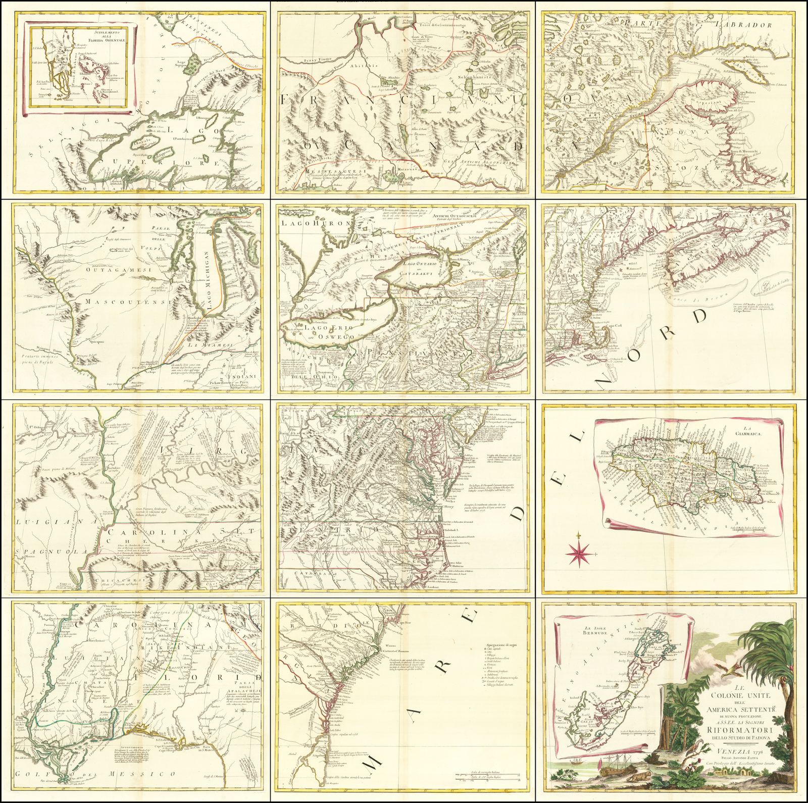 |
| 6. Zatta, Antonio LE / COLONIE UNITE / DELL’ / AMERICA SETTENTR.LE / DI NUOVA PROJEZIONE / A S.S.E.E. LI SIGNORI / RIFORMATORI / DELLO STUDIO DI PADOVA. / [rule] / VENEZIA 1791 / PRESSO ANTONIO ZATTA. [Sheet 12: 5c-5e] From Zatta’s ‘Atlante Novissimo’, 1779 [-1799] | |
| 7. Bonne, Rigobert LES ETATS UNIS DE L’AMÉRIQUE SEPTENTRIONALE, / contenant en outre, / LES ISLES ROYALE.S, DE TERRE NEUVE, DE S.T JEAN ET L’ACADIE; / AVEC PARTIE DU CANADA, DE LA LOUISIANE ET DE LA FLORIDE. / Par M. BONNE, Ingénieur-Hydrographe de la Marine. / Juillet, 1781. [2a – 4a] 320 x 213mm. From L’Abbe Grenet’s ‘Atlas Portatif …’, [1787] | |
| 8. Klockhoff, H. CARTE / GÉNÉRALE / des Treize / ETATS-UNIS / & Indépendants / DE L’AMÉRIQUE SEPTENTRIONALE / d’après M.R BONNE, / Ingénieur Hydrographe / de la Marine / de France. / 1782. [4d] H. Klockhoff, sculp. Amst. [5e] 410 x 410mm. From Alexander Cluny’s ‘Le Voyageur Américain’, 1782 | |
| 9. Klockhoff, H. CARTE / GÉNÉRALE / des Treize / ETATS-UNIS / & Indépendants / DE L’AMÉRIQUE SEPTENTRIONALE / Pour Servir / au / SPECTATEUR / AMÉRICAIN. / 1784. [4d] H. Klockhoff, sculp. Amst. [5e] 416 x 407mm. From Joseph Mandrillon’s ‘Le Spectateur Americain’, 1784 | |
| 10. Anonymous Le Tredici Colonie Unite Dell’America Settentrionale Per Servire Alla Storia Dell’ Anno 1781. 165 x 230mm. From ‘Storia Politica Dell’Anno 1781’, 1782 | |
| 11. Roeder, T.C. de ‘Nauwkeurige Kaart Van De XIII Provintien Der Vereenigde Staaten Von Noord America. Te Amsterdam Bij Allart En Holtrop.’ ‘T.C. De Roeder Fec. Et Delin.’ ‘P. Mol. Sculps.’ 190 x 220mm. From Robin’s ‘Nieuwe Reize Door Noord-Amerika’, 1782 | |
| 12. Bowles, John Carington BOWLES’s NEW POCKET MAP OF THE UNITED STATES OF AMERICA; the British Possessions of Canada, Nova Scotia, and Newfoundland, with the French and Spanish Territories of Louisiana and Florida, as Settled by the Preliminary Articles of Peace signed at Versailles the 20.th Jan.y 1783. … Carington Bowles 4 Feb 1783 … 470 x 510mm. Separate publication, 1783 | |
| 13. Bowles, John Carington BOWLES’S NEW POCKET MAP OF THE UNITED STATES OF AMERICA; the British Possessions of Canada, Nova Scotia, and Newfoundland, with the French and Spanish Territories of Louisiana and Florida, as Settled by the Preliminary Articles of Peace signed at Versailles the 20.th Jan.y 1783. … Carington Bowles … 12 April 1784 … 320 x 213mm. Separate publication, 1784 | |
| 14. Bowles, John Carington BOWLES’S / NEW ONE SHEET MAP / OF THE / UNITED STATES / OF AMERICA: / WITH THE / TERRITORIES / BELONGING TO / GREAT BRITAIN / AND SPAIN. / [rule] / LONDON. / Printed for & Sold by the Proprietors / BOWLES & CARVER, / at the Map & Print Warehouse, / N.o 69 S.t Pauls Church Yard. [4c] Published as the Act directs 12.th Jan.y 1795. [3e, ob] 320 x 213mm. Separate publication, 1795 | |
| 15. Bowles, John Carington BOWLES’S / NEW ONE SHEET MAP / OF THE / UNITED STATES / OF AMERICA: / WITH THE / TERRITORIES / BELONGING TO / GREAT BRITAIN / AND SPAIN. / [rule] / LONDON. / Printed for & Sold by the Proprietors / BOWLES & CARVER, / at the Map & Print Warehouse, / N.o 69 S.t Pauls Church Yard. [4c] 320 x 213mm. Separate publication, [ca.1800] | 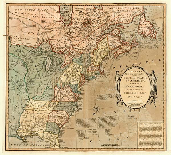 |
| 16. Bowles, John Carington BOWLES’S / NEW ONE SHEET MAP / OF THE / UNITED STATES / OF AMERICA: / WITH THE / TERRITORIES / BELONGING TO / GREAT BRITAIN / AND SPAIN. / [rule] / LONDON. / Printed for & Sold by the Proprietors / BOWLES & CARVER, / at the Map & Print Warehouse, / No. 69 S.t Pauls Church Yard. [4c] 320 x 213mm. Separate publication, [ca. 1810] | South Carolina has been reduced in size, with a corresponding increase in the size of Georgia. The old Mississippi country is now divided by a dotted line, and distinctive colouring, into Mississippi and Alabama territories, although they are not yet named. |
| 17. Jefferys, Thomas THE UNITED STATES / OF AMERICA / with THE BRITISH POSSESSIONS OF / CANADA, NOVA SCOTIA & of NEWFOUNDLAND / Divided with THE FRENCH: / and THE SPANISH TERRITORIES OF / LOUISIANA and FLORIDA / according to the Preliminary Articles of Peace / Signed at Versailles the 20.th Jan. 1783. / LONDON. / Printed for R. Sayer & J. Bennett, Map and Printsellers N.o 53 Fleet Street, / as the Act directs 9.th February, 1783. [4e] 460 x 513mm. Separate publication, 1783 | Printed from an existing plate, first published by Thomas Jefferys in 1755. |
| 18. Jefferys, Thomas THE UNITED STATES / OF AMERICA / with THE BRITISH POSSESSIONS OF / CANADA, NOVA SCOTIA & of NEWFOUNDLAND / Divided with THE FRENCH: / and THE SPANISH TERRITORIES OF / LOUISIANA and FLORIDA / according to the Preliminary Articles of Peace / Signed at Versailles the 20.th Jan. 1783. / LONDON. / Printed for Robert Sayer, N.o 53 Fleet Street, as the Act directs, 1st. January 1790. [4e] 460 x 513mm. Separate publication, 1790 | |
| 19. Jefferys, Thomas THE UNITED STATES / OF AMERICA / with THE BRITISH POSSESSIONS OF / CANADA, NOVA SCOTIA, NEW BRUNSWICK / and NEWFOUNDLAND divided with THE FRENCH. / also THE SPANISH TERRITORIES OF / LOUISIANA and FLORIDA / according to the Preliminary Articles of Peace / Signed at Versailles the 20.th Jan. 1783. / [rule] / LONDON. / Published by LAURIE & WHITTLE, 53 Fleet Street / as the Act directs 12.th May 1794. [5e] 460 x 513mm. From Laurie & Whittle atlases, 1794 | 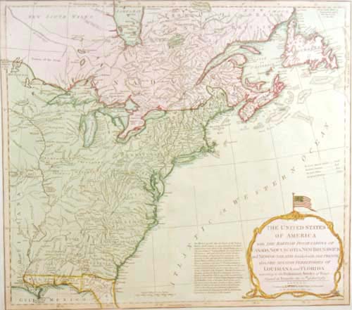 The United States flag now surmounts the title cartouche; above the title is a note explaining the coloring, in four lines. New Brunswick is named within the map, between Nova Scotia and Newfoundland. |
| 20. Jefferys, Thomas THE UNITED STATES / OF AMERICA / with THE BRITISH POSSESSIONS OF / CANADA, NOVA SCOTIA, NEW BRUNSWICK / and NEWFOUNDLAND divided with THE FRENCH. / also THE SPANISH TERRITORIES OF / LOUISIANA and FLORIDA / according to the Preliminary Articles of Peace / Signed at Versailles the 20.th Jan. 1783. / [rule] / LONDON. / Published by LAURIE & WHITTLE, 53 Fleet Street / as the Act directs 12.th May 1794. [5e] 460 x 513mm. From Laurie & Whittle atlases, [ca. 1805] | another issue: with the plate unchanged, but with Louisiana colored as part of the United States, by whom it was purchased in 1803. |
| 21. Andrews, John Andrews’s New Map Of The United States Of North America, Together With Canada, Nova Scotia, Newfoundland, the Floridas, West Indies, Bay of Honduras, Mosquito Shore, and Part of Terra Firma, Compiled from Lopez’s 4 Sheet Map of the West Indies: Cuba, from a Spanish Manuscript: all the Sands, from Dutch & French Charts: America, from the best Surveys, and Divided according to the Treaty of Peace 1783. London, Publish’d as the Act directs, February 12th 1783 by John Andrews No.2a, opposite Air Street, Piccadilly, & John Harris, No. 3, Sweetings Alley, Cornhill. 1120 x 1550mm. Separate publication, 1783 | |
| 22. Wallis, John [Untitled Map of the United States] Woodman & Mutlow sculp. [5e, ob] Published 18 March, 1783, by J. Wallis, at his Map & Print Warehouse, Ludgate St.t London. [2e, ob – 4e, ob] 108 x 78 Border: 153 x 181mm. Separate publication, 1783 | |
| 23. Wallis, John [Untitled Map of the United States] 108 x 78 Border: 153 x 181mm. Separate publication, [ca. 1785] | another state: with the American flag flag added in the background; ‘On Liberty’ is engraved on Franklin’s book, and ‘Resolution’ added on the scroll at his feet; five lines of poetry appear in place of Wallis’ imprint. |
| 24. Wallis, John THE / UNITED STATES / of / AMERICA. / laid down / From the best Authorities. / Agreeable to the Peace of / – 1783. – / Published, April 3.d 1783, / by the Proprietor / JOHN WALLIS. / at his Map-Warehouse, / Ludgate Street / LONDON. [5e] 470 x 560mm. Separate publication, 1783 | The title cartouche is a very close copy of Wallis’s untitled map of the United States, flanked by Washington and Franklin, but with the central oval now containing the title. |
| 25. Kitchin, Thomas Sr. MAP / of the / UNITED STATES / in / NORTH AMERICA: / with the / British, French and Spanish / DOMINIONS adjoining. / according to the Treaty of / 1783. / [rule] / By Tho.s Kitchin Sen.r / Hydrographer to his / MAJESTY. [4d] Published by T. Cadell according to Act of Parliament May 1.st 1783. [3e, ob] Published by T. Cadell according to Act of Parliament May 1.st 1783. [3e, ob] 410 x 508mm. Separate publication, 1783 | 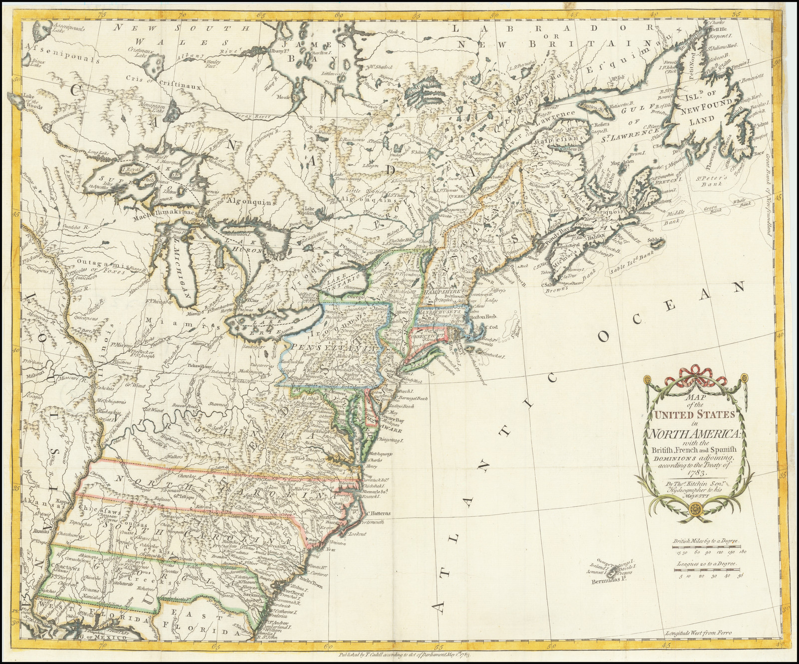 Originally a separate publication, the map was subsequently used to illustrate the English edition of Raynal’s history of the Americas (London, 1787), and seems to have appeared in other (as yet unidentified) books. |
| 26. Kitchin, Thomas Sr. MAP / of the / UNITED STATES / in / NORTH AMERICA: / with the / British, French and Spanish / DOMINIONS adjoining. / according to the Treaty of / 1783. / [rule] / By Tho.s Kitchin Sen.r / Hydrographer to his / MAJESTY. [4d] 410 x 508mm. Separate publication ?, [ca. 1790] | another state: with the imprint erased. |
| 27. Fielding, John NORTH AMERICA / including the / UNITED STATES / and / their Boundaries. / Agreeable to the Peace, of / 1783. [5e] Woodman & Mutlow, sculp. [5e, ob] Published, June 1.st 1783, by J. Fielding N.o 23, Paternoster-Row. [2e, ob – 4e, ob] 113 x 177mm. From [Anonymous] The Polite Traveller …’, 1783 | 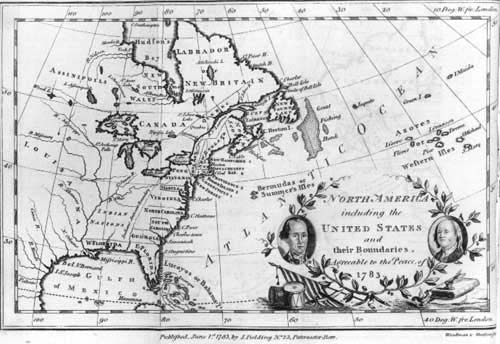 |
| 28. Cary, John AN / ACCURATE MAP / OF THE / UNITED STATES / OF / AMERICA, / with Part of the / SURROUNDING PROVINCES / agreeable to the Treaty of Peace of / 1783. / By IN.O CARY [4c] LONDON, Published as the Act directs, Aug.t 6.th 1783, by J. CARY, Map & Printseller, N.o 188, the Corner of Arundel Street, Strand. [4d] 598 x 667mm. Separate publication, 1783 | |
| 29. Dunn, Samuel A NEW MAP OF THE / UNITED STATES / OF NORTH AMERICA / with the BRITISH DOMINIONS / ON THAT CONTINENT &c. / By Samuel Dunn, Mathematician; / Improved from the Surveys of Cap.t Carver. [5d] 40 [5e, ob] London, Printed For Rob.t Sayer & Jn.o Bennett, N.o 53, Fleet Street, As The Act Directs, Oct. 9 1783. [3e, ob] 473 x 305 From Dunn’s ‘Atlas of the Mundane System’, 1783 | Printed from an existing plate, first published in 1774. Among the insertions are a list of the American States and British dominions, and additional notes. |
| 30. Dunn, Samuel A NEW MAP OF THE / UNITED STATES / OF NORTH AMERICA / with the BRITISH DOMINIONS / ON THAT CONTINENT &c. / By Samuel Dunn, Mathematician; / Improved from the Surveys of Cap.t Carver. [5d] 40 [5e, ob] London, Printed For ROB.T SAYER, Map & Sea Chartseller, N.o 53, Fleet Street, As The Act Directs, Oct. 9 1786. [3e, ob] 473 x 305 From Dunn’s ‘Atlas Of The Mundane System’, 1787 | |
| 31. Dunn, Samuel A NEW MAP OF THE / UNITED STATES / OF NORTH AMERICA / with the BRITISH DOMINIONS / ON THAT CONTINENT &c. / By Samuel Dunn, Mathematician; / Improved from the Surveys of Cap.t Carver. [5d] 40 [5e, ob] Published 12.th May 1794 by LAURIE & WHITTLE, N.o 53, Fleet Street, London. [3e, ob] 473 x 305 From Dunn’s ‘Atlas Of The Mundane System’, 1794 | |
| 32. Fielding, John A / MAP / of the / UNITED STATES / – of – / AMERICA, / As settled by the Peace of / 1783. / [rule] / Published Dec.r 1, 1783, by I. Fielding, Paternoster Row. [1e] EUROPEAN MAGAZINE. [3a, ob] 208 x 250mm. From the ‘European Magazine …’ | 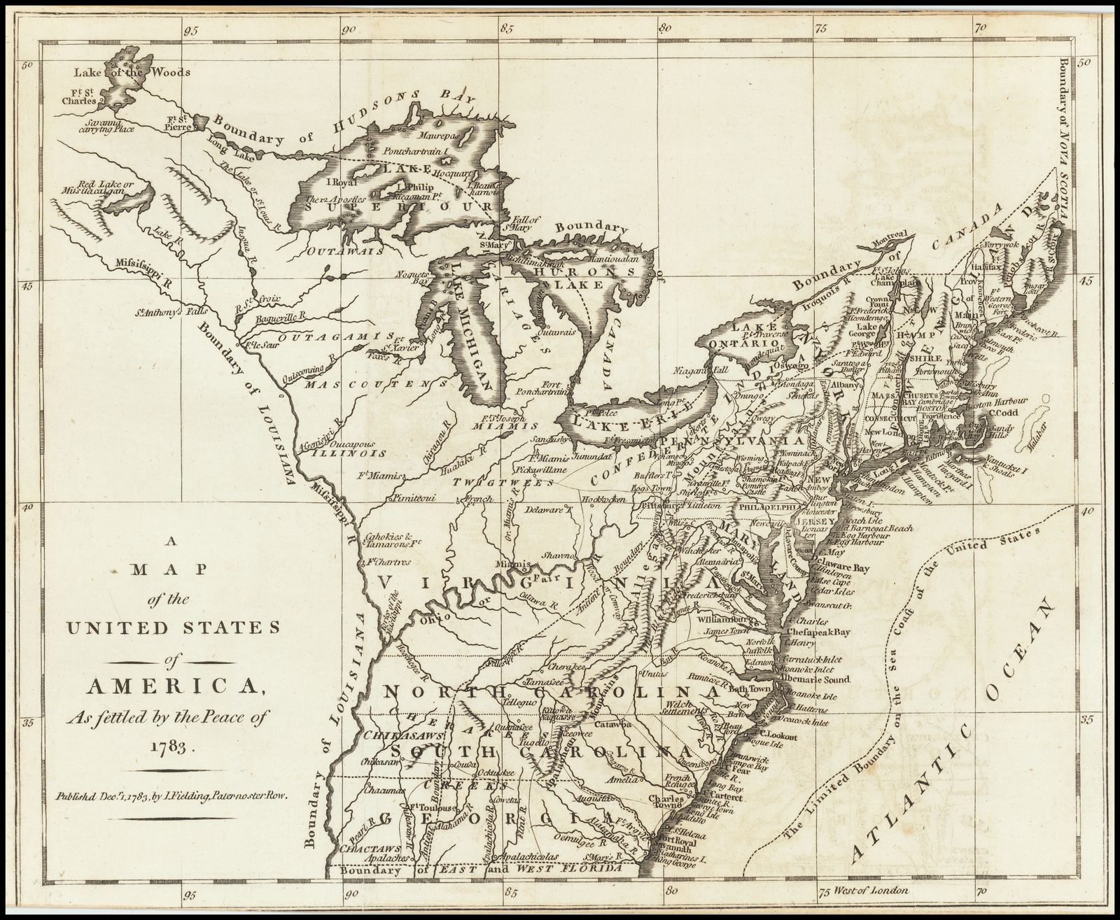 |
| 33. Fielding, John A / MAP / of the / UNITED STATES / – of – / AMERICA, / As settled by the Peace of / 1783. / [rule] / Published Dec.r 1, 1785, by I. Fielding, Paternoster Row. [1e] 208 x 250mm. From John Andrews’ ‘History Of The War …’, 1785 | |
| 34. Anonymous CARTE / GÉNÉRALE / des Treize / ETATS UNIS / Indépendants DE L’AMÉRIQUE SEPTE[N]TRIONALE / d’après M. BONNE / Ingenieur Hydrographe / de la Marine de / France. [4d] 405 x 385mm. From Alexander Cluny’s ‘Le Voyageur Americain’, 1783 |  |
| 35. Anonymous CARTE / GÉNÉRALE / des Treize / ETATS-UNIS / Indépendants / DE L’AMÉRIQUE SEPTE[N]TRIONALE / Pour Servir / au / SPECTATEUR / AMÉRICAIN. / 1785. [4d] 405 x 385mm. From Joseph Mandrillon’s ‘Le Spectateur Américain’, 1785 | 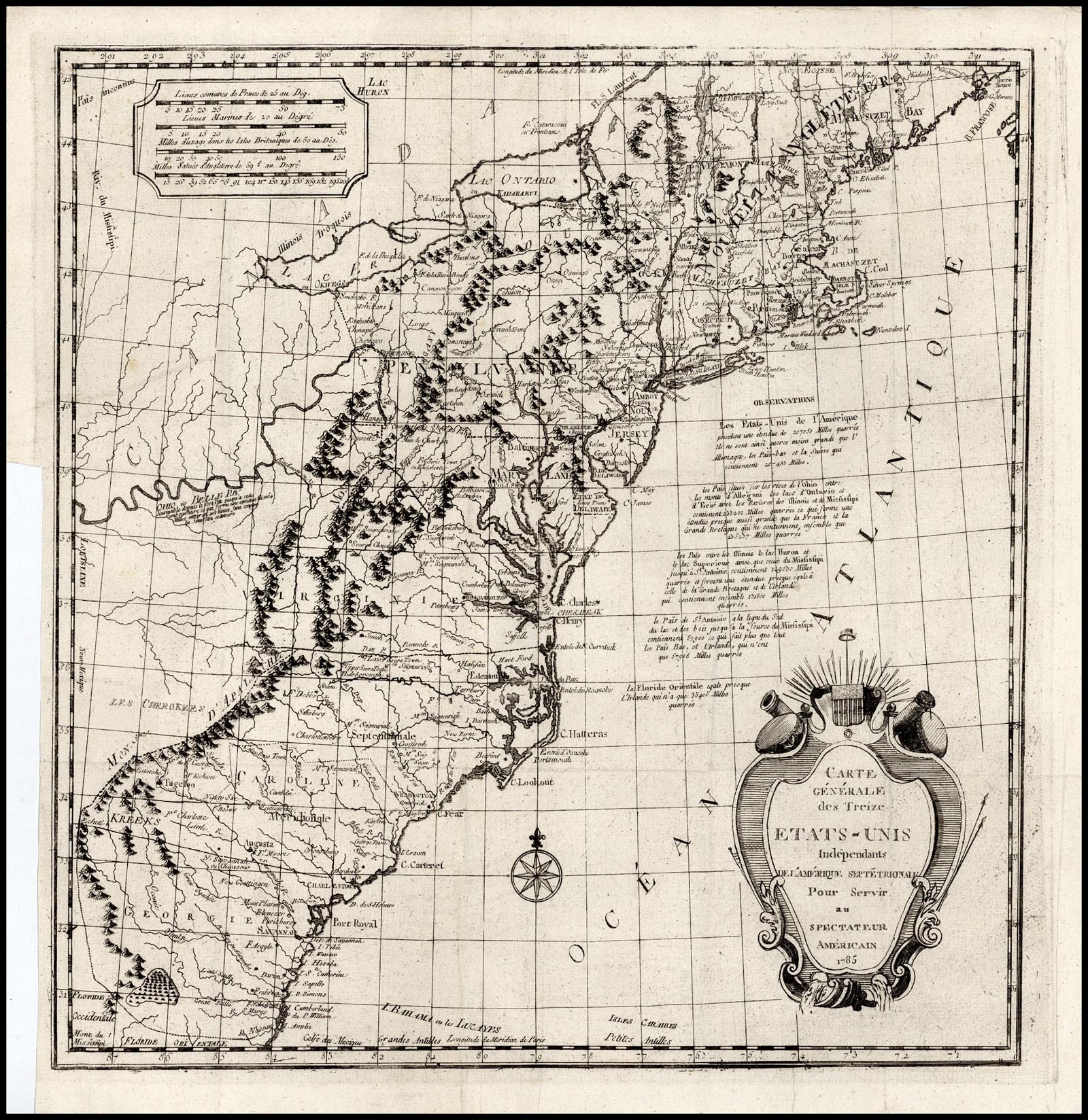 |
| 36. Bonne, Rigobert PARTIE DE L’AMERIQUE SEPTENTRIONALE, qui comprend le Canada, la Louisiane le Labrador, le Groenland, les Etats-Unis et la Floride. Projetée et assujettie aux Observations. Par M.r Bonne. A Paris, Chez Lattre, rue S.t Jacques, a la Ville de Bourdeaux. avec Priv. du Roy. Revue et corrigée 1783. [top sheet, 1a] XXXIV [top sheet, 1a, ob] A 32 [top sheet, 5a, ob] CANADA II.e FEUILLE [bottom sheet, 3a, ob] XXXV [bottom sheet, 1a, ob] A 33 [bottom sheet, 5a, ob] 430 x 290mm each sheet. From Bonne et al ‘Atlas Moderne’, 1787 | The map was first published in 1762. Within the map, ‘ETATS UNIS’ is engraved across the face of the map, and the boundaries with Canada and Florida inserted. The sheets were issed as consecutive sheets in the atlas, with their own borders, although they can be joined, with the resultant loss of the title and page number for the lower sheet. |
| 37. Bonne, Rigobert PARTIE DE L’AMERIQUE SEPTENTRIONALE, qui comprend le Canada, la Louisiane le Labrador, le Groenland, les Etats-Unis et la Floride. Projetée et assujettie aux Observations. Par M.r Bonne. A Paris, Chez Lattre, rue S.t Jacques, a la Ville de Bourdeaux. avec Priv. du Roy. Revue et corrigée 1783. [top sheet, 1a] XXXIV [top sheet, 1a, ob] A 32 [top sheet, 5a, ob] ETATS UNIS DE L’AMERIQUE [bottom sheet, 3a, ob] XXXV [bottom sheet, 1a, ob] A 33 [bottom sheet, 5a, ob] 430 x 290mm each sheet. From Bonne et al ‘Atlas Moderne’, 1787 | another state: the title of the lower sheet now refers to the ‘Etats Unis.’ |
| 38. Brion de la Tour, Louis CARTE / DES ETATS-UNIS / DE L’AMÉRIQUE / SEPTENTRIONALE, / dressée d’après des Cartes Anglaises; / Par M. Brion de la Tour, Ingénieur-Géographe du Roi. / A PARIS, / Chez le S. Desnos, Ingénieur-Géographe de Sa Majesté / Danoise, rue Saint Jacques, au Globe. [5d] 230 x 256mm. From Brion de la Tour’s ‘Almanach Intéressant’, [1783] | |
| 39. Brion de la Tour, Louis CARTE / DES ETATS-UNIS / DE L’AMÉRIQUE / SEPTENTRIONALE, / dressée d’après des Cartes Anglaises; / Par M. Brion de la Tour, Ingénieur-Géographe du Roi. / A PARIS, / Chez le S. Desnos, Ingénieur-Géographe de Sa Majesté / Danoise, rue Saint Jacques, au Globe. [5d] 230 x 256mm. From Brion de la Tour’s ‘Almanach Interessant’, [1783] | Another issue: within a decorative border, which is printed from a separate plate. |
| 40. Covens, Jean & Mortier, Corneille CARTE GENERALE / des / TREIZE ETATS UNIS, / de l’Amerique Septentrionale / KAART / van de / DERTIEN VERÉNIGDE / STAATEN, / in Nord Amerika. / a Amsterdam chez C. MORTIER & J. COVENS et Fils. [1b] 412 x 567mm. Separate publication, [ca. 1783] | 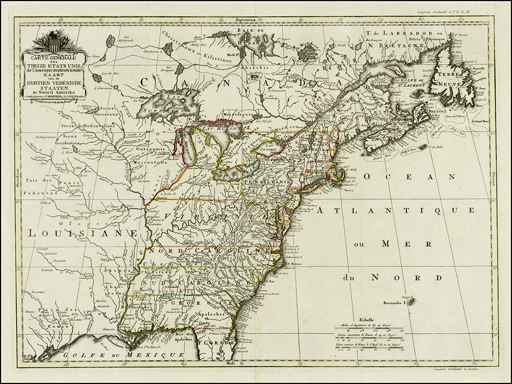 The plate was first published by Reiner & Joshua Ottens in 1755. |
| 41. Eliot, Jean Baptist Carte Générale des Etats Unis de l’Amerique Séptentrionale, avec les limites de chacun des dits Etats, convenus par le traite provisional du mois de novembre 1782. Par J.B. Eliot. … Paris. Chez Mondhare … 1783. 550 x 750mm. Separate publication, 1783 | |
| 42. Faden, William THE / UNITED STATES / of / NORTH AMERICA. / with the / BRITISH & SPANISH TERRITORIES / according to the TREATY. / Engrav’d by W. Faden. / 1783. [4e] 526 x 632mm. Separate publication, 1783 | First published in 1777. The title has been re-engraved, as above, to name the United States. In Nova Scotia, two rivers are named the ‘S.t Croix’, both of which run into the ‘BAY OF FUNDY’ [4b] |
| 43. Faden, William THE / UNITED STATES / of / NORTH AMERICA. / with the / BRITISH & SPANISH TERRITORIES / according to the TREATY. / Engrav’d by W. Faden. / 1783. [4e] 526 x 629mm. Separate publication, 1783 | another state: A new note, relating to the St. Croix River has been added below the colour key. Of the two rivers in Nova Scotia named the ‘S.t Croix’ in the previous state, now only the easternmost is so named. |
| 44. Faden, William THE / UNITED STATES / of / NORTH AMERICA. / with the / BRITISH & SPANISH TERRITORIES / according to the TREATY. / Engrav’d by W. Faden. / 1785. [4e] Published as the Act directs Feb.y 11. 1785 by Will.m Faden, Geographer to the King Charing Cross. [3e, ob] 525 x 631mm. Separate publication, 1785 | another state: with the title revised and Faden’s imprint added outside the lower border. In the colour key, the United States is now yellow and France blue. |
| 45. Faden, William THE / UNITED STATES / OF NORTH AMERICA: / with the / BRITISH TERRITORIES, / AND THOSE OF SPAIN, / according to the TREATY, of 1784 / Engraved by W.m Faden / 1793. [4e] Published as the Act directs Feb.y 11. 1793 by Will.m Faden, Geographer to the King Charing Cross. [3e, ob] 525 x 631mm. Separate publication, 1793 | another state: with the title, re-engraved, dated 1793 in the title, and imprint; a fifth colour, purple, has been added in the key. |
| 46. Faden, William THE / UNITED STATES / OF NORTH AMERICA: / with the / BRITISH TERRITORIES, / AND THOSE OF SPAIN, / according to the TREATY, of 1784 / Engraved by W.m Faden / 1793. [4e] Published as the Act directs Feb.y 11. 1793 by Will.m Faden, Geographer to the King Charing Cross. [3e, ob] 525 x 631mm. Separate publication, 1793 | 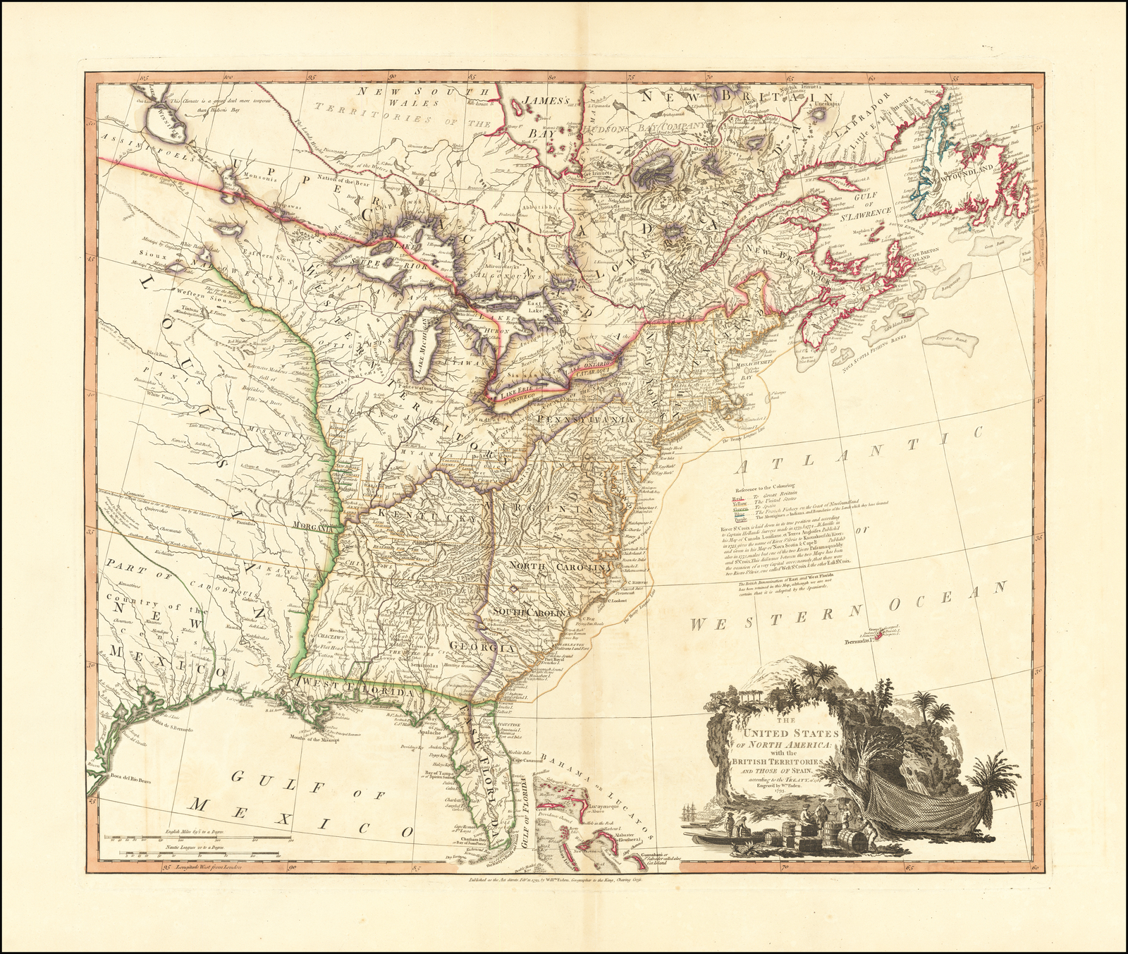 another state: the second of two states dated 1793. A three line note ‘The British Denomination of East and West Florida’ has been added below the text on the St. Croix River [4c] A large number of additions have been made in the map, particularly between the Appalachian Mountains and the Mississippi, ‘WESTERN TERRITORY’ [2b], ‘KENTUCKY’ [2c] ‘MORGANIA’ [2c] and ‘FRANKLINIA / New State of Franklin’ appear. |
| 47. Faden, William THE / UNITED STATES / OF NORTH AMERICA: / with the / BRITISH TERRITORIES, / AND THOSE OF SPAIN, / according to the TREATY, of 1784 / Engraved by W.m Faden / 1796. [4e] Published as the Act directs Feb.y 11. 1796 by Will.m Faden, Geographer to the King Charing Cross. [3e, ob] 525 x 631mm. Separate publication, 1796 | 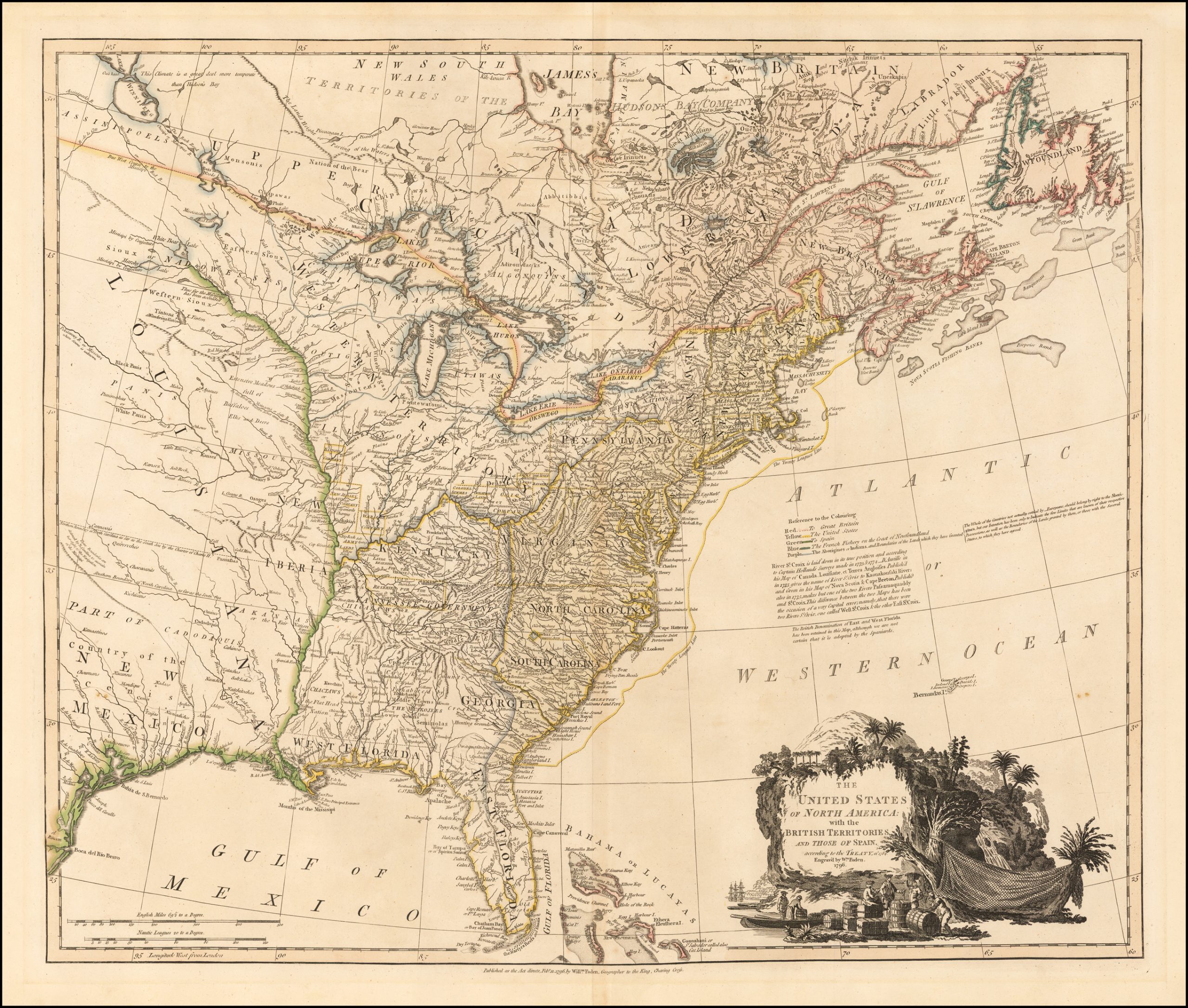 another state: the second of two states dated 1793. A three line note ‘The British Denomination of East and West Florida’ has been added below the text on the St. Croix River [4c] A large number of additions have been made in the map, particularly between the Appalachian Mountains and the Mississippi, ‘WESTERN TERRITORY’ [2b], ‘KENTUCKY’ [2c] ‘MORGANIA’ [2c] and ‘FRANKLINIA / New State of Franklin’ appear. |
| 48. Faden, William THE / UNITED STATES / OF NORTH AMERICA: / with the / BRITISH TERRITORIES, / AND THOSE OF SPAIN, / Published by W. Faden, Charing Cross, / Geographer to His Majesty, and to / His Royal Highness the Prince of Wales, 1809. [4e] 525 x 631mm. Separate publication, 1809 | 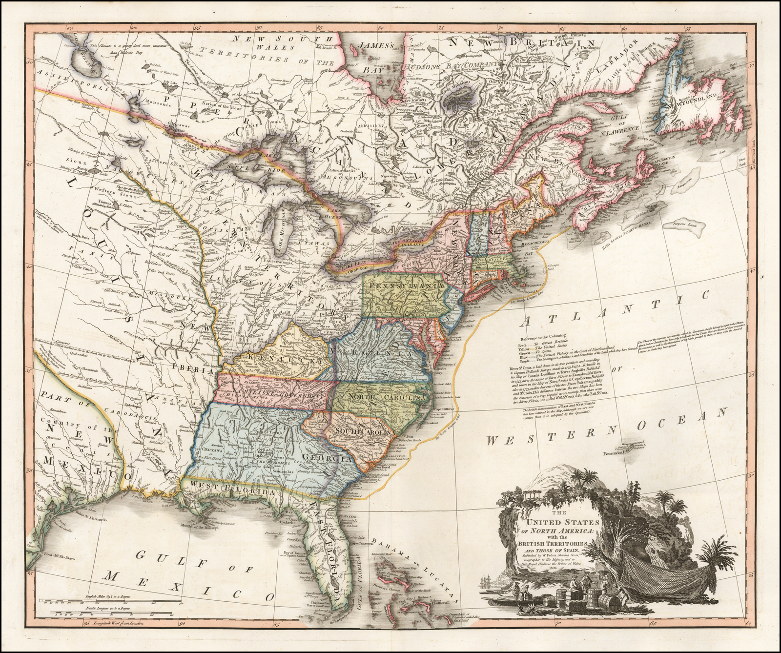 another state: the title has been re-engraved as above. Alterations and additions have been made in western Canada, and Nova Scotia. Subsequent states, published to 1843, fall outside the scope of this list; |
| 49. Sotzmann, D.F. Die Vereinigten Staaten von Nord-America, nach der von W.m Faden 1783 herausgegebenen Charte, auf welcher alle im englisch americanischen Kriege vorzüglich merkwurdig gewordenen Örter angezeigt, auch die Grenzen zwischen Grosbrittanien, America und Spanien nach Maasgabe des Friedensschulusses von bestimmt sind. Les Etats Unis de l’Amerique Septentrionale … Genau zugesammengetragen von D. Sotzmann. … 200 x 260mm. From ‘Historisch-Genealogischer Calender’, [1783] | |
| 50. Sprengel, Matthias Christian Die / Vereinigten Staaten / von / NORD=AMERICA. / nach der von W.m Faden 1783 / herausgegebenen Charte, / auf welcher alle im englisch americanischen / Kriege vorzüglich merkwürdig gewordenen / Orter angezeigt, auch die Grenzen zwi= / schen Grosbrittan[n]ien America und Spa= / nien nach Maasgabe des Friedens schlus= /ses von 1783 bestimmt sind. / [rule] / Les Etats unis de I’Amerique / Septentrionale (d’après la Carte de W.m / Faden publiée à Londres en 1783) con= / tenant tous les endroits rendus memo= / rables dans la guerre anglo-ameri= / caine et indiquant les limites assignées / à la Grande Bretagne, l’Amerique unie / et l’Espagne, par la paix de 1783. [4c-4d] J. Marianus sculp. A.V. [5e, ob] 195 x 255mm. From Sprengel’s ‘Historisches Taschenbuch’, [1785] | 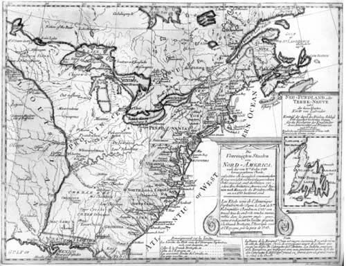 |
| 51. Bowen, Thomas A / CORRECT MAP / of the / UNITED STATES / of / NORTH AMERICA. / Including the British and Spanish / Territories, carefully laid down / agreeable to the Treaty of 1784 / by T. Bowen, Geog.r [4d] Engraved for BANKES’S New System of Universal GEOGRAPHY, Published by Royal Authority. [2a, ob – 4a, ob] 316 x 448mm. From Bankes ‘… New System Of Geography…’ [1784-1810] | 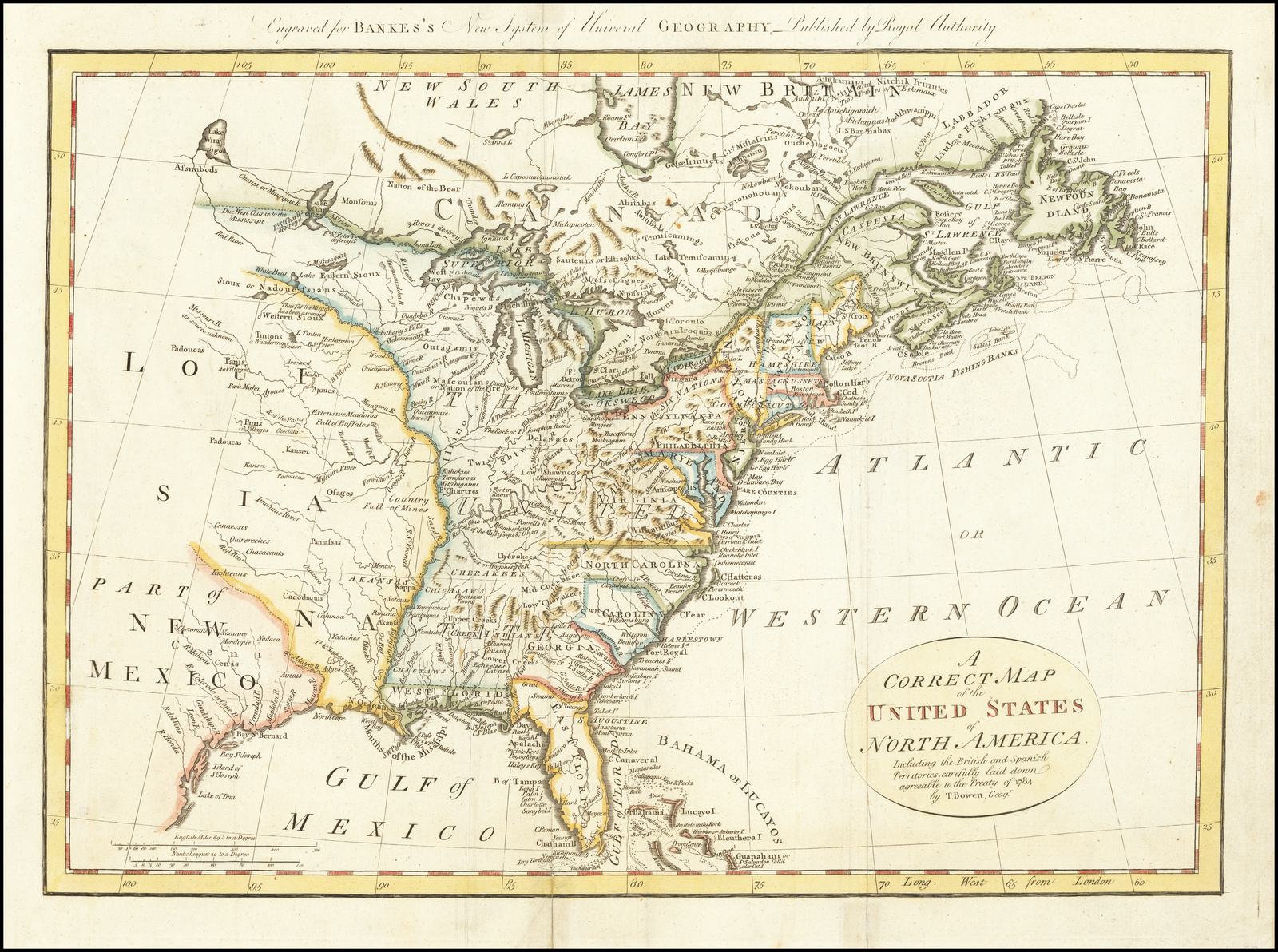 |
| 52. Brion de la Tour, Louis CARTE / DES ETATS-UNIS / D’AMÉRIQUE, / et / DU COURS DU MISSISSIPI; / redigée d’apres différentes Cartes et Relations Anglaises, / et les opérations de la derniere Guerre: / avec / LES NOUVELLES LIMITES GÉNÉRALES fixées par les articles préliminaires de paix, / signés tant a Paris qu’a Versailles, le 30 9.bre 1782 et le 20 Jan.r 1783, / et confirmées par le Traite definitif du 3 7.bre 1783. / [rule] / Cette carte composée par le S.r Brion de la Tour, Ing.r Géographe du Roi, / est acompagnée de celle de l’Amérique Septentrionale, entière, / servant aussi à l’intelligence des mêmes articles de paix. / [rule] / A Paris, Chez Esnauts et Rapilly, rue S.t Jaques, à la Ville de Coutances, 1784. A.P.D.R. [5e] 510 x 700mm. Separate publication, 1784 | |
| 53. Brion de la Tour, Louis CARTE / DES ETATS-UNIS / D’AMÉRIQUE, / et / DU COURS DU MISSISSIPI; / redigée d’apres différentes Cartes et Relations Anglaises, / et les opérations de la derniere Guerre: / avec / LES NOUVELLES LIMITES GÉNÉRALES fixées par les articles préliminaires de paix, / signés tant a Paris qu’a Versailles, le 30 9.bre 1782 et le 20 Jan.r 1783, / et confirmées par le Traite definitif du 3 7.bre 1783. / [rule] / Cette carte composée par le S.r Brion de la Tour, Ing.r Géographe du Roi, / est acompagnée de celle de l’Amérique Septentrionale, entière, / servant aussi à l’intelligence des mêmes articles de paix. / [rule] / A Paris, chez le S.r Desnos, Ing.r Geog.ge rue S.t Jacques, au Globe, N.o 254. 510 x 705mm. Separate publication, [ca. 1785] |  |
| 54. Buell, Abel A / NEW and correct MAP / of the / UNITED STATES / of / North America / Layd down from the latest Observations and / best Authorities agreeable in the PEACE of / 1783. / Humbly Inscribed to His Excellency the / Governor and Company / of the STATE of CONNECTICUT / By their / most Obedient / and very humble servant / Abel Buell. [5e] 1100 x 1225mm. Separate publication, [1784] | The first American map of the United States. |
| 55. Buell, Abel A / NEW and correct MAP / of the / UNITED STATES / of / North America / Layd down from the latest Observations and / best Authorities agreeable in the PEACE of / 1783. / Humbly Inscribed to His Excellency the / Governor and Company / of the STATE of CONNECTICUT / By their / most Obedient / and very humble servant / Abel Buell. / NEWHAVEN, Published according to Act of ASSEMBLY. [5e] 1100 x 1225mm. Separate publication, [1784] | another state: with the addition of the imprint. |
| 56. Gussefeld, Frans Ludwig CHARTE / uber die XIII vereinigte / Staaten von / NORD-AMERICA, / Entworfen durch F.L. Güssefeld, / und herausgegeben von den / Homænnischen Erben. / Mit Romisch Kaÿserl. Allergn. / Freÿheit A.o 1784. [4d] Les XIII Etats unis de I’Amerique Septentrionale, d’apres les meilleures & speciales Cartes angloises qui ont parues jusqu’ici par F.L. Gussefeld. Chez les Heritieres de Homann, l’an 1784. [2a, ob – 4a, ob] I.M. Schmidt sc. Nor. [1e] 448 x 575mm. From Homann’s Heirs ‘Atlas Geographicus Maior …’ [ca.1784] | |
| 57. Lattre, Jean CARTE DES ETATS-UNIS / DE L’AMERIQUE / Suivant le Traité de Paix de 1783. / DÉDIÉE ET PRÉSENTÉE / A S. Excellence M.r BENJAMIN FRANKLIN / Ministre Plénipotentiaire des Etats-Unis de l’Amerique près la Cour de France, / anc Presid. De la conuentio[n]. De Pensilvanie et de la Societé Philosophique de Philadelphie, &c. &c. / Par son tres humble et très obeissant / Serviteur LATTRÉ. / 1784. / avec Privilege du Roi. [4d, on the sails of a ship] A PARIS Chez LATTRÉ Graveur du Roi Rue s.t Jacques N.o 20. [4e, ob] 560 x 760mm. Separate publication, 1784 | 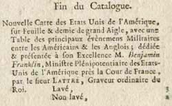 extract from an undated Lattré catalogue. |
| 58. McMurray, William THE / UNITED STATES / According to the Definitive Treaty of Peace signed at Paris, Sep.t 3.d 1783 / In forming this Map, late Particular Maps & Charts, were of great use, but what contributed / most to its accuracy, were the unpublished Surveys, consisting of many thousand of Miles, forming / a connection thro’ the whole (except what lies N.W. of the double dotted line) which Surveys / with many good sketches, have been furnished for this usefull work, by the Geog.rs and other / curious Gentlemen, who for particular purposes, had made large collections of them / This Map may therefore be said, to be composed from every Survey and sketch / of Note, heretofore made in these Limits, conformed to the best Astronomical Observations, / By W.m McMurray, late / Ass.t Geog.r to the U.S. [3a] R. Scot, sculp. [5e] 670 x 960mm. Separate publication, [1784] | |
| 59. Morse, Jedidiah A Map of the United States of America. mm. From Morse’s ‘Geography Made Easy’, 1784 | |
| 60. Morse, Jedidiah ‘A Map of the United States of America.’ ‘A. Doolittle sc.’ mm. From Nathan Salomon’s ‘An Astronomical Diary …’, 1785 | another state: with the addition of the engraver’s name. |
| 61. Morse, Jedidiah ‘A Map of the United States of America.’ ‘A. Doolittle sc.’ ‘IV’ 670 x 960mm. From Morse’s ‘Geography Made Easy’ Third Edition, 1790 | another state: with the plate number engraved outside the top left border; some names of rivers and places have been added, including ‘Kentucky’, ‘Pitsburg’, ‘Marietta’, ‘Patomack R.’, ‘James R.’ and ‘Savanah River.’ |
| 62. Moser, Johann Jakob Karte des oestliche[n] oder ehemahlige[n] englischen Amerika nach den Besitzungen und Graenzen nach dem Frieden von 1783. 220 x 280mm. From Moser’s ‘Nord-America’, 1784 | |
| 63. Pursell, Henry D. A Map of the United States of N. America’ ‘Philad.a Engraved by H.D. Pursell for F. Bailey’s Pocket Almanac.’ 135 x 175mm. From ‘Bailey’s Pocket Almanack’, [1784] | |
| 64. Pursell, Henry D. A Map of the United States of N. America’ ‘Philad.a Engraved by H.D. Pursell.’ 670 x 960mm. From John M’Culloch’s ‘History Of America’, 1787 | another state: the reference to ‘Bailey’s Pocket Almanac’ in the imprint has been erased. |
| 65. Darton, William A MAP of the / UNITED STATES / of / AMERICA / Agreeable to the Peace of / 1783. [4d] W.m Darton sc. Tottenham. [5e, ob: very faint] Engraved for Guthries new System of Geography. [3a, ob] 352 x 391mm. From Guthrie’s ‘New System Of Modern Geography’, [1785] | |
| 66. Delamarche, Charles François ETATS-UNIS / DE L’AMÉRIQUE SEPTENTRIONALE / Avec / LES ISLES ROYALE, DE TERRE NEUVE, / DE S.T JEAN, L’ACADIE, &c. / 1785. / A Paris, chez Delamarche, Géog.r du Foin S.t / Jacques au College de Maître Gervais. [1b] 475 x 625mm. From Delamarche’s ‘Atlas’, [1785] | |
| 67. Delamarche, Charles François ETATS-UNIS / DE L’AMÉRIQUE SEPTENTRIONALE / Avec / LES ISLES ROYALE, DE TERRE NEUVE, / DE S.T JEAN, L’ACADIE, &c. / 1785. / Supplement a l’Atlas de M. Robert de Vaugondy. / a Paris Ches Boudet Ingenieur du Roi. [1b] 480 x 640mm. From Robert de Vaugondy’s ‘Atlas Universel’, [1785] | 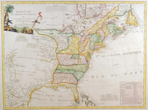 another state: with the imprint revised. |
| 68. Lattre, Jean ETATS-UNIS / DE L’AMERIQUE SEP.le / avec / le Canada et la Floride. [1a] N.o 25 [5e, orb] 250 x 183mm. From Lattre’s ‘Petit Atlas Moderne’, 1787 | |
| 69. Tardieu, Pierre François CARTE GÉNÉRALE / DES ETATS-UNIS / DE L’AMERIQUE SEPTENTRIONALE, / renfermant aussi / quelques Provinces Angloises adjacentes, / pour les Lettres d’un Cultivateur Ameriquain. [5e, ob] Gravé par P.F. Tardieu. [1e, ob] T. I.er P.1. [1a, ob] 259 x 427mm. From Michel de Crevecoeur ‘Lettres D’Un Cultivateur Ameriquain’, 1787 | |
| 70. Bonne, Rigobert LES ÉTATS UNIS / DE / L’AMÉRIQUE SEPTENTRIONALE. / Partie Orientale. / Par M. BONNE, Ingénieur-Hydrographe / de la Marine. [5d] Andre sculp. [5e, ob] 117 [5a, ob] 343 x 233mm. From Desmarest & Bonne’s ‘Atlas Encyclopaedique’, 1788 | 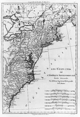 |
| 71. Conder, Thomas The United States Of America …’ ‘T. Conder Sculp.t’ ‘Engraved For Dr. Gordon’s History Of The American War.’ 290 x 290mm. From Gordon’s ‘History Of The American War’, 1788 | |
| 72. Schopf, Johann David [Schöpf] A MAP of the / United States / of N. AMERICA. [2d] 135 x 175mm. From Schopf ‘s ‘Nordamerikanischen Staaten’, 1788 | |
| 73. Brion de la Tour, Louis CARTE / DES ETATS-UNIS / D’AMÉRIQUE / ET DU COURS DU MISSISSIPI. [5d] Mist. Univ. Part mod. [1a, ob] Tom.116. Page 134. [5a, ob] 221 x 269mm. From Brion de la Tour’s ‘Histoire Universelle’, Paris, 1779-1794 | 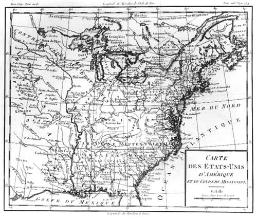 |
| 74. Anonymous A Map of the / UNITED STATES / – OF – / AMERICA, / with Part of the / ADJOINING PROVINCES / from the latest Authorities. [4d] 210 x 272mm. [an unidentified English Geographical Book] [ca. 1790] | |
| 75. Conder, Thomas The / UNITED STATES / of / AMERICA, / Drawn from the / Latest Authorities. [5e] T. Conder Sculp.t [5e, ob] 196 x 227mm. From: [?] [ca. 1790] | |
| 76. Workman, Benjamin The United States Of America. 170 x 225mm. From Workman’s ‘Elements Of Geography’, 1790 | |
| 77. Workman, Benjamin The United States Of America. 170 x 225mm. From Workman’s ‘Elements Of Geography’ 4th Edition, 1793 | another state: The map has been revised and updated, particularly in the regions around the Mississippi. |
| 78. Workman, Benjamin The United States Of America. 170 x 225mm. From McCulloch’s ‘Concise History’ 2nd Edition, 1797 | another state: Tennassee’ (so spelled) is inserted in the map, replacing the name ‘Southern Territory’. A later state was published in 1807 |
| 79. Carleton, Osgood The / UNITED STATES / of / AMERICA / laid down / From the best Authorities / Agreeable to the Peace of / 1783 / … / Osgood Carleton / Teacher of Mathematicks. [5e] BOSTON / Published & Sold by I. Norman / N.o 75 Newbury Street. [5e, in border] 830 x 1150mm. Separate publication, [1791] | |
| 80. Carleton, Osgood A New Map Of The / UNITED STATES / of / AMERICA /… / Osgood Carleton … [5e] BOSTON / Published & Sold by W. Norman / N.o 75 Newbury Street. [5e, in border] 830 x 1150mm. Separate publication, [ca. 1796] | another state 2: with the title re-engraved, and William Norman’s name substituted in the imprint. The inset has been replaced by ‘A Table Exhibiting The Length Breadth And Population Of Each State … A Table Of The Post Roads And Distances …’ Within the map, the ‘Federal City of Washington’ is identified. |
| 81. Gibson, John The / United / STATES / of / AMERICA. [1e] 43 [5e, orb] 63 x 94mm. From Gibson’s ‘Atlas Minimus’, 1792 | The second state of a map published in 1758. |
| 82. Morse, Jedidiah ‘A Map Of The United States Of America.’ ‘A. Doolittle Sc. N. Haven.’ ‘Engraved For The Abridgement Of Morse’s American Universal Geography.’ 200 x 230mm. From Morse’s ‘Geography Made Easy’ 4th Edition, 1794 | |
| 83. Wilkinson, Robert A Map of the / UNITED STATES / – Of – / AMERICA, / with Part of the / ADJOINING PROVINCES / from the latest Authorities. [5d] T. Conder Sculp.t [5e, ob] London. Published June 2.d 1794. by R. Wilkinson, No. 58 Cornhill. [3e, ob] 215 x 276mm. From Wilkinson’s ‘General Atlas’, 1795 | |
| 84. Reid, John AN / ACCURATE MAP / of the / UNITED STATES / of / AMERICA. / according to the Treaty of Peace of / 1783. [4d] Russell del et sculp. [5e, ob] London, Publish’d as the Act directs, Oct. 18, 1794, by H.D. Symonds, N.o 20 Pater Noster Row. [3e, ob] 366 x 465mm. From Reid’s ‘The American Atlas’, 1795 | |
| 85. Lewis, Samuel A Map Of The United States: Compiled Chiefly From The State Maps, And Other Authentic Information, By Sam.l Lewis 1795.’ ‘W. Harrison Jun.r Sculp.t’ 615 x 695mm. Separate publication, 1795 | |
| 86. Lewis, Samuel A Map Of The United States: Compiled Chiefly From The State Maps, And Other Authentic Information, By Sam.l Lewis 1795.’ ‘W. Harrison Jun.r Sculp.t’ ‘Engraved For And Sold By Matthew Carey Philadelphia.’ 615 x 695mm. Separate publication, 1795 | another state: with the addition of the imprint. |
| 87. Lewis, Samuel A Map Of The United States: Compiled Chiefly From The State Maps, And Other Authentic Information, By Sam.l Lewis 1795.’ ‘W. Harrison Jun.r Sculp.t’ ‘Engraved For And Sold By Matthew Carey Philadelphia.’ 615 x 695mm. From ‘Carey’s General Atlas’, 1796 | another state: described by Wheat & Brun thus: “This map may be identified by the uneven depth of the shading lines in Chesapeake Bay, Albemarle Sound, and Lake George”, while the previous state had the shading evenly performed. Wheat & Brun, 133; |
| 88. Lewis, Samuel A Map Of The United States: Compiled Chiefly From The State Maps, And Other Authentic Information, By Sam.l Lewis 1795.’ ‘W. Harrison Jun.r Sculp.t’ ’24’ Engraved For And Sold By Matthew Carey Philadelphia. 615 x 695mm. From ‘Carey’s General Atlas’, 1800 | another state: with the plate number added outside the border. |
| 89. Morse, Jedidiah A Map Of The United States Of America.’ ‘Engraved For Morse’s Elements Of Geography, Published By Thomas & Andrews, Boston. 120 x 135mm. From Morse’s ‘Elements Of Geography’, 1795 | |
| 90. Scott, Joseph A Map Of The United States. 275 x 370mm. From Scott’s ‘United States Gazetteer’, 1795 | |
| 91. Smith, Charles ‘The United States Of America.’ ‘Scoles Sc.’ 165 x 210mm. From Smith’s ‘Universal Geography’, 1795 | |
| 92. Bradley, Abraham Jr. Map / of the / United States, / Exhibiting the / POST-ROADS, the situations, connections & distances of the POST-OFFICES / Stage Roads, Counties, Ports of Entry and / Delivery for Foreign Vessels, and the Principal Rivers. / – BY – / Abraham Bradley jun.r / W: Harrison Jun.r sc. [3d] A MAP / OF THE / United States / Exhibiting Post Roads & Distances / BY / Abraham Bradley Jun.r / The first Sheet comprehending the / Nine Northern States, with parts of Virginia / and the Territory North of Ohio. [3a] Border: 863 x 934mm. Separate publication, [1796] | |
| 93. Bradley, Abraham Jr. Map / of the / United States, / Exhibiting the / POST-ROADS, the situations, connections & distances of the POST-OFFICES / Stage Roads, Counties, Ports of Entry and / Delivery for Foreign Vessels, and the Principal Rivers. / – BY – / Abraham Bradley jun.r / W: Harrison Jun.r sc. [3d] A MAP / OF THE / United States / Exhibiting Post Roads & Distances / BY / Abraham Bradley Jun.r / The first Sheet comprehending the / Nine Northern States, with parts of Virginia / and the Territory North of Ohio. [3a] Deposited as the Act directs September 26.th 1796. [1a, ob] B: 863 x 934mm. Separate publication, [1796] | another state: with the addition of the dated imprint. |
| 94. Bradley, Abraham Jr. Map / of the / United States, / Exhibiting the / POST-ROADS, the situations, connections & distances of the POST-OFFICES / Stage Roads, Counties, Ports of Entry and / Delivery for Foreign Vessels, and the Principal Rivers. / – BY – / Abraham Bradley jun.r / W: Harrison Jun.r sc. [3d] A MAP / OF THE / United States / Exhibiting Post Roads & Distances / BY / Abraham Bradley Jun.r / The first Sheet comprehending the / Nine Northern States, with parts of Virginia / and the Territory North of Ohio. [3a] Deposited as the Act directs September 26.th 1796. [1a, ob] B: 863 x 934mm. Separate publication, [1796] | another state: within Georgia is added the note ‘All West is claimed by the U.S. and by Georgia’, with an appropriate boundary line inserted. The map continued to be re-issued after 1800. |
| 95. Arrowsmith, Aaron Sr. A MAP OF THE / UNITED STATES / of / NORTH AMERICA / Drawn from a number of Critical Researches / By A. ARROWSMITH, / Geographer / Charing Cross / Soho Square. [5d] London. Published as the Act Directs, Charles Street, Soho Square, Jan.y 1.st 1796 [2e, ob] London, Published as the Act Directs, Charles Street, Soho Square, Jan.y 1.st 1796 [4e, ob] 1425 x 1234mm. Separate publication, 1796. | |
| 96. Arrowsmith, Aaron Sr. A MAP OF THE / UNITED STATES / of / NORTH AMERICA / Drawn from a number of Critical Researches / By A. ARROWSMITH, / Geographer / Charing Cross / Soho Square. [5d] London. Published as the Act Directs, Charles Street, Soho Square, Jan.y 1.st 1796 [2e, ob] London, Published as the Act Directs, Charles Street, Soho Square, Jan.y 1.st 1796 [4e, ob] 1420 x 1230mm. Separate publication, 1796. | another state: The address has been altered, and ‘TENNASSEE’ is so named in the map. |
| 97. Arrowsmith, Aaron Sr. A MAP OF THE / UNITED STATES / of / NORTH AMERICA / Drawn from a number of Critical Researches / By A. ARROWSMITH, / Geographer / N.o 24 Rathbone Place. [5d] London. Published as the Act directs by A. Arrowsmith, N.o 24 Rathbone Place Jan. 1.st 1796. Additions to 1802. [2e, ob] London. Published as the Act directs by A. Arrowsmith, N.o 24 Rathbone Place Jan. 1.st 1796. Additions to 1802. [4e, ob] 1425 x 1234mm. Separate publication, 1802 | 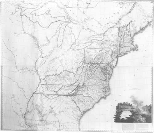 another state: a large number of additions and alterations have been made in the map, most noticeably for the mouth of the Mississippi River and the coast of West Florida. There are a number of later states. |
| 98. Reid, John AN / ACCURATE MAP / of the / UNITED STATES / of / AMERICA. / according to the Treaty of Peace of / 1783. / A. Anderson Sculp. [4d] 361 x 455mm. From Reid’s ‘The American Atlas’, 1796 | |
| 99. Reid, John AN / ACCURATE MAP / of the / UNITED STATES / of / AMERICA. / according to the Treaty of Peace of / 1783. / A. Anderson Sculp. [4d] Published by Smith, Reid and Wayland. 361 x 455mm. From Reid’s ‘The American Atlas’, 1796 | another state: with the addition of the publishers’ imprint. |
| 100. Reid, John AN / ACCURATE MAP / of the / UNITED STATES / of / AMERICA. / according to the Treaty of Peace of / 1783. / A. Anderson Sculp. [4d] Published by John Reid, N. York. 361 x 455mm. Reid ‘The American Atlas’, 1796 | another state: with the publishers’ imprint altered. |
| 101. Carey, Mathew The / UNITED STATES / of / AMERICA. / W. Barker sculp. Philadelphia. [4d] 245 x 315mm. From ‘Carey’s American Pocket Atlas’, 1796 | A later state, published in 1801, contains many additional names. |
| 102. Cassini, Giovanni Maria GLI / STATI UNITI / DELL’AMERICA / Delineati sulle ultime Osservazioni. / [double rule] / PRIMO FOGLIO / che comprende inoltre / PARTE DEL CANADA. / [rule] / ROMA. / Presso la Calcografia Camerale. / 1797. [1a] Gio M.a Cassini Som inc. [5e, ob] [6 sheets, each separately titled] 345 x 479mm each sheet. From Cassini’s ‘Nuovo Atlante Geografico …’, 1798 | 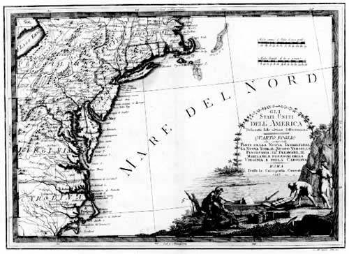 |
| 103. Kearsley, George ‘UNITED STATES / – OF – / AMERICA. [4d] Neele sculp.t Strand. [4d] Published by G. Kearsley Fleet Street London, March 11.th 1797. [3e, ob] 345 x 396mm. From: [?] |  |
| 104. Wilkes, John ‘UNITED STATES OF AMERICA.’ ‘Neele sc. 352 Strand.’ London Pub.d as the Act directs Feb.y 18.th 1797, by J. Wilkes. 185 x 240mm. From Wilkes ‘Encyclopaedia Londinensis’, 1797 | |
| 105. Smith, Charles THE UNITED STATES of AMERICA. B. Tanner sculp.t’ ‘Published by C. Smith, New-York’ 165 x 220mm. From Smith’s ‘Monthly Military Repository’, 1797-1798 | |
| 106. Cassini, Giovanni Maria GLI / STATI UNITI / DELL’ / AMERICA / IL CANADA, E LA FLORIDA / Carta Generale delineati sulle ultime Osservaz.ni. / [rule] / ROMA / Presso la Calcografia Camerale. / 1798. [5d] Gio M.a Cassini Inc. [5e, ob] 345 x 475mm. From Cassini’s ‘Nuovo Atlante Geografico …’ 1798 | |
| 107. Cassini, Giovanni Maria ‘Carte Générale des États-Unis de l’Amérique Septentrionale, renfermant aussi quelques Provinces Angloises adjacentes.’ ‘Tardieu sculp.’ ‘André scrip.’ 325 x 430mm. From Mentelle & Chanlaire’s ‘Atlas Universel’ 1798 | |
| 108. Weld, Isaac PART / of the / UNITED STATES / OF / AMERICA. Published 13.th Nov.r, by J. Stockdale, Piccadilly. [3e, ob] 410 x 490mm. From Weld’s ‘Travels Through The States Of America’ 1799 |  |
| 109. Schneider & Wengel DIE / VEREINIGTEN STAATEN / von / Nordamerica / nach / Arrowsmith und Lewis Karten von Jahre 1795 und 1796. / [rule] / Nürnberg 1799 / in der Schneider= und Wengelschen K.K. privilegirten Kunsthandlung. [5d] 534 x 648mm. Separate publication, 1799 | |
| 110. Capitaine, Louis Carte Generale Des Etats-Unis De L’Amerique Septentrionale, Divisee En Ses 17 Provinces. Par L. Capitaine I.er Ingenieur et Associe De La Carte Gen.le De France …’ 445 x 395mm. From Francois, Duke de la Rochefoucault-Liancourt’s ‘Voyage …’ 1799 | |
| 111. Rochefoucault Liancourt, Francois Alexandre Frederic, Duke de la Map of the UNITED STATES, CANADA &c. intended to illustrate the Travels of the Duke de la Rochefoucault Liancourt. [1a, ob – 5a, ob] Smith & Jones sculp. 13, Pleasant Row, Pentonville. [5e, ob] London Published as the Act directs, July 1.st 1799, by R. Phillips, St. Pauls Church Yard. [3e, ob] 406 x 337mm. From Rochefoucault Liancourt’s ‘Travels Through The United States’ 1799 | |
| 112. Rochefoucault Liancourt, Francois Alexandre Frederic, Duke de la ‘Map of the UNITED STATES, CANADA the River S.t Lawrence, the Lakes &c. [1a, ob – 3a, ob] Smith & Jones sculp. 13, Pleasant Row, Pentonville. [5e, ob] London Published as the Act directs Feb.y 15.th 1801, R. Phillips, St. Pauls Church Yard. [2e, ob – 4e, ob] 407 x 338 Platemark: 427 x -mm. Rochefoucault Liancourt ‘Travels’, 1801 | 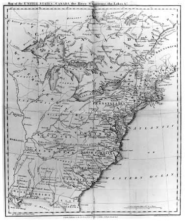 another state: withe considerable additions of place-names within the map. |
| 113. Rochefoucault Liancourt, Francois Alexandre Frederic, Duke de la [Untitled Map Of The United States] Smith & Jones sculp. 13, Pleasant Row, Pentonville. [5e, ob] 405 x 332 Platemark: 426 x 354mm. Rochefoucault Liancourt ‘Travels Through The United States’, 1806 | another state: The title and publisher’s imprint have been erased. Roads have been added throughout the mapand many names added within the map. |
| 114. Anonymous DIE / VEREINIGTEN / STAATEN / und / die Besitzungen d. Engländer von Nordamerica. [4d] XVI [5a, ob] 110 x 163mm. [ca. 1800?] | 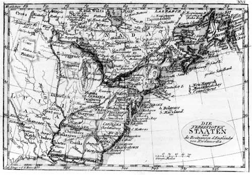 |
| 115. Anonymous ETATS-UNIS / ET POSSESSIONS ANGLAISES / DE L’AMÉRIQUE SEPTENTRIONALE. [4d] 39 [5a, ob] 100 x 163mm. [ca. 1800?] | 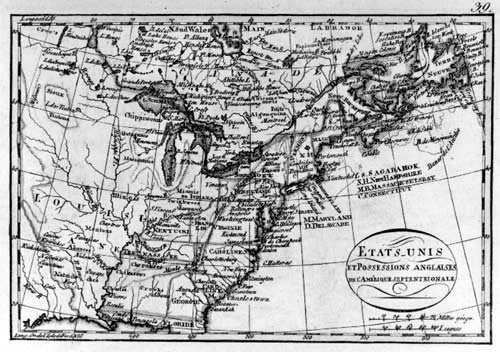 |
| 116. Gussefeld, Frans Ludvig CHARTE / DER XV VEREINIGTEN STAATEN / von / NORD-AMERICA / Nach Murdochischer Projection entworfen nach den / neuesten astronomischen Ortsbestimmungen berichtiget / und gezeichnet von / F.L. GÜSSEFELD. / [rule] / Weimar im Verlage des Industrie Comptoirs. / 1800. [4d] 468 x 525mm. From [?] | 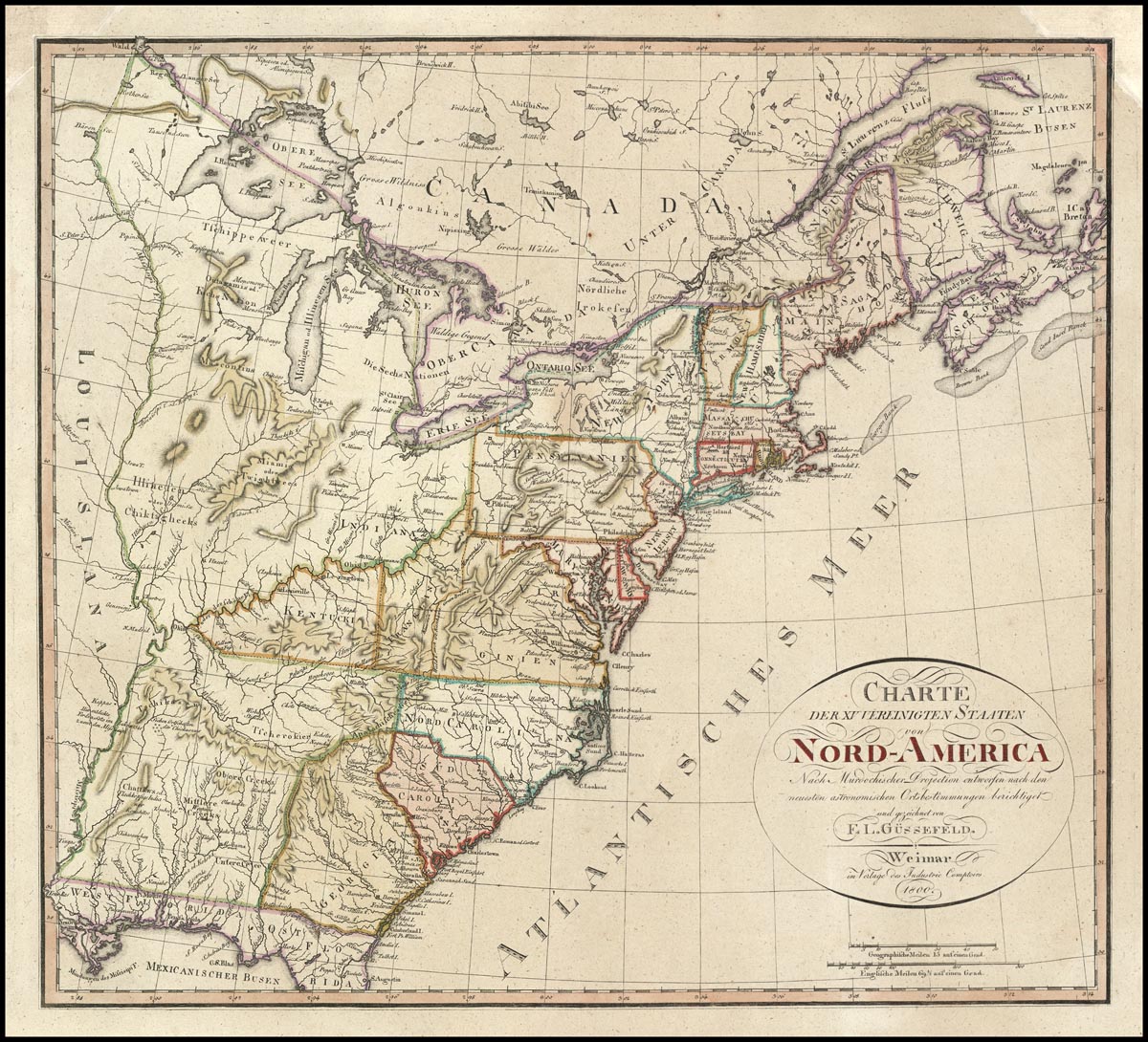 |
| 117. Jattnig, Carl [Jättnig] PART of the UNITED STATES OF AMERICA nach dem Englischen Original gestochen von Carl Jättnig in Berlin. 1800. 410 x 470mm. From Weld’s ‘Resien Durch Die Staaten Nord-Amerika’, 1800 |