One of the must frustrating facets of the study of early map-publishing in Britain is how little we know about the day-to-day business of the people involved. A small number produced catalogues, albeit on an incidental basis, while more advertised in newspapers of the day, such as the London Gazette, or in The Term Catalogues. These references give an insight into the nature of an individual’s stock, and so often tantalizing references to maps that are lost. What we sadly lack are the records the publishers might have kept, which usually survived only a short time beyond the publisher’s immediate demise.
It is possible to trace their baptism records, their apprenticeship records and their wills, but in only a very small number of cases do we have their portraits or descriptions of their shops. It is hard to position a shop before street numbering was introduced: if a shop sign or a local landmark changed it is often impossible to tell if the publisher moved to a new address.
Below are depicted three engravings that, quite by chance, include a map-publisher’s shop.
The Prospect of Westminster Hall
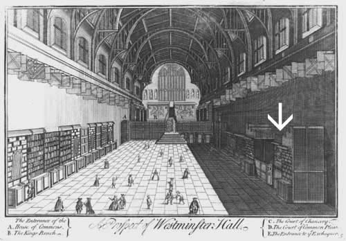
An eighteenth century copy, with minor revisions, of a engraving from the 1690s. In the key, “D” denotes the Court of Common Pleas; immediately before the door way can just be seen Philip Lea’s stall. In the original engraving, the hanging item was apparently a wall-map of England and Wales, but it is not so clearly depicted in this version.
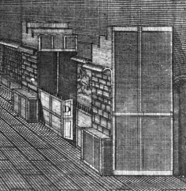
Philip Lea was one of the leading English map-makers and publishers of his day, active between about 1683 and his death in 1700. The Westminster Hall address was a secondary one, used between 1689 and 1695, and which is found principally in advertisements, for example:
A True Survey of the Baronie of Ennishowen in Ireland … Likewise a true Survey of the City of Londonderry, and Prospect. By Captain Thomas Phillips, Enginier. Sold by Philip Lea Globe-maker in Cheapside at the Atlas and Hercules and in Westminster-Hall near the Court of Common-Pleas. In a large Sheet, Price 1s. (London Gazette, August 15th-19th 1689)
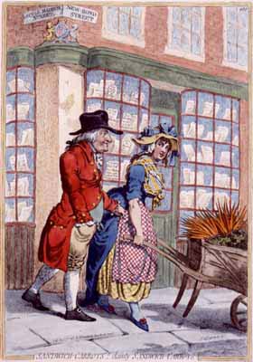
The Carrot Seller
In the background of this Gillray print is shown the shop of the prominent bookseller and publisher, Robert Faulder (fl. cica 1780 -1805), on the corner of Maddox Street and New Bond Street. While not known as a map-publisher, per-se, a number of his publications did include maps. For example, he published Samuel Henshall’s Map Of Kent From The Autograph Of Domesday Anno 1086., in Henshall and John Wilkinson’s Domesday; Or, An Actual Survey Of South-Britain: Kent, Sussex And Surrey …, published in 1799.
Faulder was also one of the booksellers listed on the title-page of James Clarke’s A Survey Of The Lakes Of Cumberland, Westmorland, And Lancashire: Together With An Account, Historical, Topographical, And Descriptive, Of Adjacent Country, which contained 11 large folding maps of the lakes.
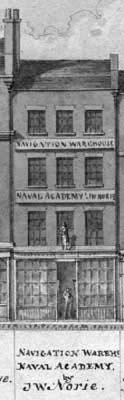
Leadenhall Street
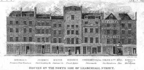
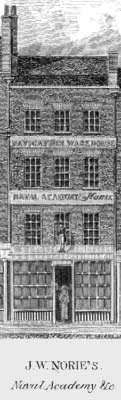
The second shop from the left, 157 Leadenhall, is that of John William Norie (1722-1843). The shop was first occupied by his predecessor, William Heather (fl.1765 – 1812), and then passed to Norie in 1812. Heather and Norie were among the most important independent firms of hydrographers and publishers working in London, with an extensive output of separately published charts, and sea-atlases. Norie, a gifted methematician, also gave lectures on navigation from these premises, which were retained by his successors until 1880.
The two images here are details from the engraved version, published by Robert Wilkinson in 1825, and the original manuscript draught supplied to the engraver.