| 1. | [1514 ca.]: MUNSTER ‘Kollegienbuch’[Manuscript lecture notebook, containing 44 manuscript maps compiled from a variety of sources and a map of the Rhine from Basle to Neuss, apparently composed by Munster himself; the majority of the maps are copied from the 1486 edition of the Ulm Ptolemy, or from Martin Waldseemuller’s wall-map of Europe, first published in 1511]. Manuscript on vellum, 311 leaves, 44 maps, [nd, ca. 1514/1515-] Location: Munich, Bayerische Staatsbibliothek; | Skelton, Bibliographical note to the facsimile of the 1540 Basle Ptolemy, illustrates Munster’s map of the Rhine on p.XII; Karrow, 58/A & 48/1-44 (listing the maps, with their sources); |
| 2. | 1525: MUNSTER ‘Eyn New Lüstig Vnd Kürtzweilig Instrume[n]t Der Sonne[n] Mit Yngesetzter Landtafel Teütscher Nation Gemacht Vn[d] Gericht Vff Viel Iare Durch Sebastianu[m] Münster Von Ingelnheim …’ ‘Getrückt Zü Oppenheim.’ ‘1525. S[ebastian]. M[unster].’ Separate publication, [Jacob KOBEL ?], for Sebastian MUNSTER, Oppenheim, 1525Broadsheet, measuring 720 x 350, containing a number of woodcut diagrams, including an untitled circular map of Germany, after Erhard Etzlaub. | Skelton, p.VIII; Karrow, 58/45; |
| 3a. | 1525: MUNSTER ‘Erklerung Des Newen Instruments Der Sunnen …’, [Jakob KOBEL ?, Oppenheim ?], 1525The ‘Erklerung’ was a booklet to accompany the ‘Instrume[n]t Der Sonne[n] …’; however, there is no known example of the First Edition. | Karrow: Mapmakers, 58/B; |
| 3b. | ii. another edition: ‘Erklerung Des Newen Instruments Der Sunnen … Gedruckt Durch Iacob Kobel Statschreiber Zu Oppenheym, In Iar 1528.’, Jakob KOBEL, [for Sebastian MUNSTER], Oppenheim, 1528The earliest extant edition.The volume is also interesting as evidence for Munster’s developing interests. The second part contains his appeal for assistance in preparing a description of Germany, and also gives a detailed description of the techniques he used to make the survey of the environs of Heidelberg. | Skelton, p.VIII; Karrow: Mapmakers, 58/B.1; |
| 4. | [1525?-1528]: MUNSTER ‘Heydelberger Becirck Vff 6 Meilen Beschribe[n]’A map of the environs of Heidelberg, to a radius if six miles. The map was issued in the 1528 edition of the ‘Erklerung …’, Jakob KOBEL, [for Sebastian MUNSTER], Oppenheim, 1528, where the surveying techniques employed are described. | Karrow: Mapmakers, 58/47; |
| 5. | 1526: MUNSTER [Map of the Rhine] Manuscript, [1526]The original is not known, but it was discussed by Munster in a letter to Beatus Rhenanus, in 1526. | |
| 6. | 1529: Nicolaus of CUSA [Map of Central Europe, on a trapezoidal projection] ‘Quod Picta Est Parva Germania Tota Tabella: Et Latus Italiae Gelidas Quod Prospicit Alpes: Sauromatum Que Truces Populi: Gentes Que Profundo Vicinae Adriatico: Pelopis Regnum Que Vetusti: Pannonios Et Findit Agros Qua Frigidus Hister: Atque Licaonios Terrarum Quicquid In Axes Vergit: Et Aequoreas Rhodanu Qua Verberat Undas: Et Multae Punctis Urbes Villes Que Notatae: Gracia Sit Cusae Nicolao: Murice Quondam Qui Tyrio Contectus Erat: Splendor Que Senatus Ingens Romani: Nulli Explorata Priorum: Et Loca Qui Modico Caelari Iussit In Aere.’ ‘P.P.I.’ [P.P.I.: possibly the initials of one of the craftsmen that worked on the map?] Separate publication, [Andreas CRATANDER, for Sebastian MUNSTER, Basle, 1529]Copperplate engraving, with the lettering, numerals and town symbols produced from punches;This map is described in detail by Tony Campbell, ‘Earliest Printed Maps’ (London: British Library, 1987), 4;This later state has had the additional note of the previous state, erased, except for the final letters ‘sit’, which had beeen squeezed in awkwardly by the engraver, to make them fit. (‘Communi Erudit Utilitati Chuonradus Peutinger Augustan. Iure Cons. Archetypum Aen. Pecunia Sua Emptum Ioan. Burgkmair Pictori Municipi Suo Et De Se BM Imprimendo Concessit.’)The six known surviving examples of the Cusa map are this state; the only known example of the previous state was destroyed in World War II. | |
| 7. | 1530: MUNSTER ‘Germaniae Atque Aliarum Regionum, Quae Ad Imperium Usque Costantinopolitanu[m] Protenduntur, Descriptio … Pro Tabula Nicolai Cusae Intelligenda … Basileae Mense Augusto Anno MDXXX.’, [Andreas CRATANDER, for Sebastian MUNSTER], Basle, 1530A booklet to accompany the printing of Cusa’s map. | Skelton, p.VIII; |
| 8. | [1532]: [MUNSTER attrib.] ‘Typus Cosmographicus Universalis.’Woodcut, with the lettering from type inserts; the pictorial element outside the map is generally attributed to Hans HOLBEIN the Younger.From: Johann HUTTICH [Simon GRYNAEUS ed.] ‘Novus Orbis Regionum …’, Johann HERWAGEN, Basle, 1532 (the Paris edition of 1532 contains the World map by Oronce Fine).Munster contributed a section ‘Typi Cosmographici Et Declaratio Et Usus’ explaining the world map. | Shirley, World, 67 (pl.61): noting variations in the lettering; |
| 9. | 1536: MUNSTER ‘Mappa Evropae, Eygentlich Fürgebildet, Aussgelegt Vnd Beschribenn. Von Aller Land Vnd S[t]ett Ankunfft, Gelegenheit, Sitten, Ietziger Handtierung Vnnd Wesen. Wie Weit Ein Statt Von Der Andern Gelegen, Auch Stett Vnd Länder Europe So In Diser Mappa Oder Tafel (Von Enge Wegen) Nit Verzeychnet, Leichtlich Zu Finde[n]. … Durch Sebastianum Munsterum An Tag Geben. Gedruckt Zu Franckfurt Am Meyn, Bei Christian Egenolph. 1536.’, Christian EGENOLPH, Frankfurt-am-Main, 1536The book contains three small woodcut maps:1. ‘Tabule Europe.’2. ‘Beschribung Des Rynstramss Von Basel Biss Ghan Mentz.’3. ‘Heydelberger Becirck Vff 6 Meilen Beschribe[n]’ (re-issued from the ‘Erklerung Des Newen Instruments Der Sunnen’ 1525/28) | Skelton, p.VIII; Karrow: Mapmakers, 58/ P & 58/48, 49 & 46 respectively; |
| 10. | 1537: MUNSTER ‘Beschreibung Des Hegöws: Des Schwartz Walds Und Vrsprungss Der Donaw, Im Jar Christi M.D. XXXVII. Durch Sebastianum Münster In Truck Verfasst.’ ‘Getruckt Zu Basel By Henrichen Petri.’ Separate publication, Heinrich PETRI, Basle, 1537Woodcut map, 160 x 270mm, of the Hegau region, in the Black Forest. | Karrow, 58/50; |
| 11a. | 1538: Caius Julius SOLINUS [MUNSTER ed.] ‘C. Iulii Solini Polyhistor, Rerum Toto Orbe Memorabilium Thesaurus Locupletissimus. Huic Ob Argumenti Similitudinem Pomponii Melae De Situ Orbis. Adiunximus. Accesserunt His Praeter Noua Scholia, Quae Loca Autoris Obscuriora Copiose Passim Illustrant, Etiam Tabulae Geographicae Permultae, Regionum, Locorum, Marium, Sinuusq Diuersorum Situs Pulchre Deliniantes. Basileae 1538.’ Colophon: ‘Basileae Apud Michaelem Isingrinium Et Henricum Petri. M. D. XXXVIII.’, Michael ISENGRIN & Heinrich PETRI, Basle, 1538This volume contains 20 sketchy woodcut maps. | Skelton, p.VIII; Nordenskiold Collection Catalogue, II, 285; Karrow, 58/Q & 54-72; |
| 11b. | another edition: ‘Polyhistor, Rerum Toto Orbe Memorabilium Thesaurus Locupletissimus …’, Michael ISENGRIN & Heinrich PETRI, Basle, 1543A re-printing with the same set of maps. | |
| 12a. | 1538: Aegidius TSCHUDI ‘Die Vralt Warhafftig Alpisch Rhetia, Sampt Dem Tract Der Anderen Alpgebirgen, Nach Plinij, Ptolemaei, Strabonis, Auch Anderen Welt Vn[d] Gschichtschrybern Waren Anzeygung, Durch Den Ehrneusten Vnd Wysen Herzen, Her Gilg Tschudi Von Glarüs Ettwo In Sarganser Land, Darnach Zü Baden Im Ergöw, Gmeiner Eydgnossen Landuogt, In Tütsch Spraach Züsame[n] Getragen Vnd Yetz Mit Einer Geographischen Tabel Vssgangen. Getruckt Zü Basel Bei Isingrien M D.XXXVIII.’, Michael ISENGRIN, [for Sebastian MUNSTER], Basle, 1538A description of Switzerland; although not illustrated by a map, there was a companion map of Switzerland, published separately. | Karrow: Mapmakers, 78/A; |
| 12b. | another edition: ‘Aegidii Tschvdi Claronensis, Viri Apvd Helvetios Clarissimi, De Prisca Ac Uera Alpina Rhaetia, Cum Caetero Alpinarum Gentium Tractu, Nobilis Ac Erudita Ex Optimis Quibusqv Ac Probatissimis Autoribus Descriptio. Basileae, Apud Mich. Isingrinium. M.D.XXX VIII.‘, Michael ISENGRIN, [for Sebastian MUNSTER], Basle, 1538 | Karrow: Mapmakers, 78/B; |
| 13a. | 1538: Aegidius TSCHUDI [Title ?: Nova Rhaetiae Atq[ue] Totivs Helvetiae Descriptio Per Aegidivm Tschvdvm Glaronensem.’ ‘Sebastianvs Mvnstervs Cosmographiae Stvdiosis S.D. …’] Separate publication, on nine sheets, [Michael ISENGRIN, For Sebastian MUNSTER, Basle, 1538]There is no known example of the first state of Tschudi’s map of Switzerland, but only a later printing published by Konrad Wolfhart. | Karrow: Mapmakers, 58/51.1; |
| 13b. | another state: ‘Nova Rhaetiae Atq[Ue] Totivs Helvetiae Descriptio Per Aegidivm Tschvdvm Glaronensem.’ ‘Sebastianvs Mvnstervs Cosmographiae Stvdiosis S.D. …’ ‘Conrad Lycosthenes Rubeaquensis Ad Cosmographiae Candidatos … Basiliae, In Officina Michaelis Isingrinij, M.D.L.X.’ Separate publication, on nine sheets, OFFICINA ISENGRINIANA, [For Konrad WOLFHART] Basle, 1560 | Karrow: Mapmakers, 58/51.1; |
| 14a. | 1538: MUNSTER ‘Die Löblich Vnd Wyt Berümpt Stat Basel Mit Vmbligender Landtscafft Nach Warer Geographischer Art Bescribn Durch Sebastianu[m] Munster An. M.D.XXXVIII.’ Separate publication, [Heinrich PETRI ?], For Sebastian MUNSTER, Basle, 1538Two maps on one broadsheet, the environs of Basle and a plan of the city. | Karrow, 58/52-53; |
| 14b. | another state: the title is in manuscript: ‘Das Rauracher Land Samt Der Stadt Basel Nach Geographischer Art Beschrieben Durch Sebastianum Münster 1544.’ Separate publication, [Heinrich PETRI ?], For Sebastian MUNSTER, Basle, 1544 | Karrow, 58/52-53.1; |
| 14c. | another state: ‘Basiliensis Territori Descriptio Descriptio Nova, Auctore Sebastaino Munstero 1574.’ Separate publication, [Sebastian HENRICPETRI ?, Basle], 1574 | Karrow, 58/52-53.2; |
| 14d. | another state: ‘Die Loblich Vnd Weit Berümpt Statt Basel Mit Vmbligender Landtschafft Nach Warer Geographischer Art Beschrib[e]n. Durch Sebastianum Münster, Anno 1580.’ [Text to the Reader:] ‘Dem Freündtlichen Leser. Weil Das Erste Büch Dieser Bassler Historien …’ From: Christian WURSTISEN ‘Bassler Chronick …’, Sebastian HENRICPETRI, Basle, 1580 | Karrow, 58/52-53.2 & p.729: Wurstigen; |
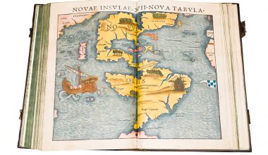
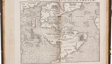
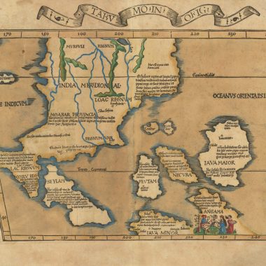
| 15a. | 1540: Claudius PTOLEMY [MUNSTER ed.] ‘Geographia Vniversalis, Tvm Vetvs Et Nova, Complectens Clavdii Ptolemaei Alexandrini Enarrationis Libros VIII. … Succedunt Tabulæ Ptolemaice, Opera Sebastiani Munster Nouo Paratæ Modo. His Adiectæ Sunt Plurime Nouæ Tabulæ … Basileae Apvd Henricvm Petrvm Mense Martio Anno M. D. XL.’ [Colophon] ‘Basileae Apvd Henricvm Petrvm Mense Martio AN M.D.XL.’, Heinrich PETRI, Basle, 154048 maps, 27 Ptolemaic, 21 modern; the text is based on Wilibald Pirckheimer’s translation, from Lorenz Fries’ editions; each map has, on the reverse, a brief descriptive text, surrounded by woodblock borders, which are attributed to Hans Holbein the Younger; | Nordenskiold Collection Catalogue, II, 210; |
| 15b. | another edition: ‘Geographia Vniversalis, Vetvs Et Nova … Basileae Apvd Henricvm Petrvm.’ [Colophon] ‘Basileae Apvd Henricvm Petrvm Mense Martio AN M.D.XLII.’ Heinrich PETRI, Basle, 1542 | Nordenskiold Collection Catalogue, II, 212; |
| 15c. | another edition: ‘Geographia Vniversalis, Vetvs Et Nova … Basileae Per Henrichvm Petrvm, Anno M. D. XLV.’ [Colophon] ‘Basileae Per Henrichvm Petrvm Mense Martio AN M.D.XLV.’ Heinrich PETRI, Basle, 1545 | Nordenskiold Collection Catalogue, II, 213; |
| 15d. | another edition: ‘Geographiae Claudii Ptolemaei. Partim A Bilibaldo Pirckheymero Translati Ac Commentario Illustrati, Partim Etiam Graecorum Antiquissimorumq Exemplariorum Collatione Emendati Atque In Integrum Restituti … Facillima Ratione In Tabulis Depictis Deprehendu[n]tur, Conradi Lycosthenis Rubeaque[n]sis Opera Adiecti. Tabulae Nouae Quae Hactenus In Nulla Ptolemaica Editione Uisae Sunt, Per Sebastianum Munsterum. Geographiae Descriptionis …’ [Colophon] ‘Basileae Ex Officina Henrichii Petri, Mense Martio, Anno M. D. LII.’, Heinrich PETRI, Basle, 1552With the exception of the modern World map, all the modern maps are printed within a graduated frame border. | Nordenskiold Collection Catalogue, II, 215; |
| 16. | 1541: [Claudius PTOLEMY] [‘Almagest’] ‘Omnia, Quae Extant Opera, Geographia Excerpta …’, Heinrich PETRI [for Sebastian MUNSTER], Basle, 15411. [Northern Celestial Hemisphere] ‘Imagines Constellationum Septentrionalium.’ ‘1532’2. [Southern Celestial Hemisphere] ‘Imagines Constellationum Meridionalium.’ | |
| 17a. | 1544: MUNSTER ‘Cosmographia ….’, Henrich PETRI, Basle 1544A very popular and off-reprinted volume; listed brelow are editions up to Munster’s death in 1552; further editions were published up to 1628.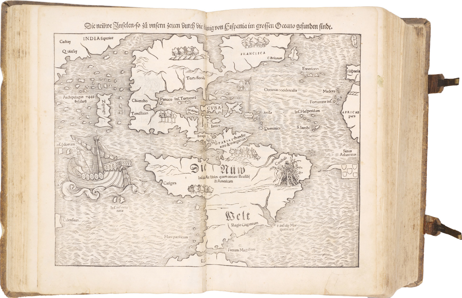 | |
| 17b. | another edition: ‘Cosmographia …’, Henrich PETRI, Basle 1545 | |
| 17c. | another edition: ‘Cosmographia …’, Henrich PETRI, Basle 1546 | |
| 17d. | another edition: ‘Cosmographia …’, Henrich PETRI, Basle 1548 | |
| 17e. | another edition: ‘Cosmographia …’, Henrich PETRI, Basle 1550 | |
| 17f. | another edition: Cosmographei, Oder Beschreibung Aller Länder …’, Heinrich PETRI, Basle, 1550 | |
| 17g. | another edition: ‘Cosmographia …’, Henrich PETRI, Basle 1552 | |
| 17h. | another edition: Cosmographei, Oder Beschreibung Aller Länder …’, Heinrich PETRI, Basle, 1552 |