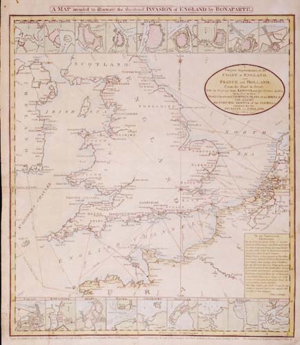
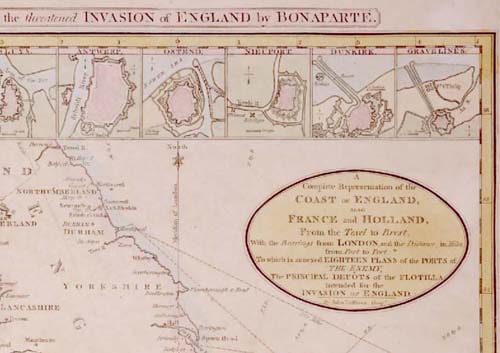
A MAP intended to illustrate the threatened INVASION of ENGLAND by BONAPARTE. [2a, ob – 4a, ob] A / Complete Representation of the / COAST OF ENGLAND, / ALSO / FRANCE and HOLLAND, / From the Texel to Brest, / With the Bearings from LONDON, and the Distance, in Miles, / from Port to Port. / To which is annexed EIGHTEEN PLANS of the PORTS of / The ENEMY, / The PRINCIPAL DEPÔTS of the FLOTILLA / intended for the / INVASION OF ENGLAND. / [rule] By John Luffman. Geog.r [4b] Engrav’d & Publish’d Nov.r 17. 1803, by John Luffman, N.o 28, Little Bell Alley, Coleman Street, London Price 1.s 6.d Plain, 2.s 6.d Coloured. Of whom may all be had all the principal Sea Ports of Holland, Spain, Portugal, & Italy. The Population of England Scotland & Wales &c.
Rare broadsheet map, published by John Luffman, in London in 1803.
Copper engraving, 403 x 353 (widest: 415 x 353), in contemporary outline colour.
John Luffman (fl. circa 1776-1820) was an accomplished engraver, mapmaker and publisher, working in London. He started his career as an engraver, with his earliest work being for two road books, Mostyn John Armstrong’s An Actual Survey Of The Great Post-Roads Between London And Edinburgh and Taylor And Skinner’s Survey And Maps Of The Roads Of North Britain, Or Scotland., both published in 1776. However, in the early years of the nineteenth century, he seems to have established himself as a publisher, issuing A New Pocket Atlas And Geography Of England And Wales in 1803.
The history of western Europe at this time is dominated by the personality and military feats of Napoleon Bonaparte. This map was published at a time of, and to capitalize on, widespread fear that Napoleon was planning to invade Britain. The map illustrates possible launch points from Continental ports, routes across the Channel, and potential landing points. The insets around the map are thumb-nail sketches of Continental ports (working in order from east to west), and include Amsterdam, Rotterdam, Antwerp, Calais, Boulogne, Dieppe and Brest.
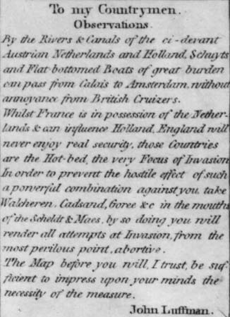
In his text to the reader, Luffman explained his motivation for issuing the map – to highlight the danger presented by France’s occupation of the Austrian Netherlands. The extensive canal system allowed the French to move men and equipment from Calais to Antwerp and Amsterdam, out of reach of the Royal Navy, and it was from here that Luffman feared that the invasion would come.
To counter this, Luffman proposed that the British should seize a number of islands at the mouth of the main rivers of the region, such as Walcheren, and thus by controlling the estuaries effectively prevent any invasion force actually putting to sea.
Despite Luffman’s fears, the threat of invasion never materialised. Not for the first (or last) time, the twenty-two miles of the English Channel proved an insurmountable barrier for a Continental enemy.