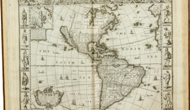
This rare sea-atlas is apparently a version of van Keulen’s Eene Verzameling Van Nieuwe Zee-Kaarten Van Noord-America In Het Groot Beginnende Van Kaap Charles, Of De Golf Van St. Laurens, Tot Aan De Golf Van Mexico …
Koeman records two examples of the sea-atlas with title-pages. The first, with the title dated 1785, is in the Nederlandsch Historisch Scheepvaartmuseum, Amsterdam. The second, with the title undated, is in the William L. Clements Library, University of Michigan.
The example being described was assembled for ship-board use, so there is no title. Also the maps are printed on very thin paper and then pasted together in such a way that the right-hand side of the first chart backs onto the left-hand of the second, and so on. The two outer pages are then covered with the traditional protective blue-backing, associated with charts supplied for ship-board use, and then stored as a roll in a pigeon-hole.
Even the individual charts are of great rarity. The British Library’s Map Library has none of the charts listed in its CD-ROM catalogue, while Sellers and van Ee list only one of the six charts in the collections of the Library of Congress.
The atlas was issued into a flooded market. A large number of sea-atlases were compiled by British and French mapmakers for use during the Revolutionary War: the market collapsed with the end of the war, and poor sales account for the rarity of the atlas today.
Untitled Sea Atlas Of The Atlantic Seaboard of North America
(ca. 1785)
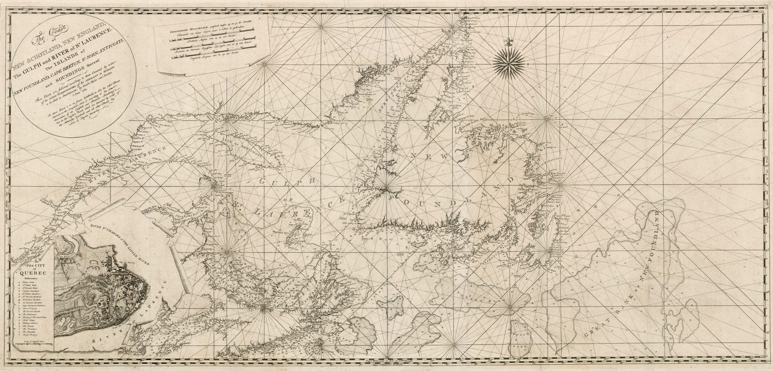
| 1 | The Coast of / NEW SCHOTLAND, NEW ENGLAND, / The GULPH and RIVER of S.T LAURENCE. / The ISLANDS of / NEW FOUNDLAND, CAPE BRETON, S.T JOHN, ANTICOSTI, / and SOUNDINGS thereof. / [rule] / These Charts are followed, according to them Executed by order / of the LORDS COMMISSIONERS of the ADMIRALTY in ENGLAND / to be Sold at AMSTERDAM, by Gerard Hulst van Keulen / Anno 1783. / In these Charts is to be found, Quebeck, as also the other Places / Situated, on the Longitude, which is according to the Latest / Observations of the English, and French Academy’s / but in the English Charts which are Executed by order of / the Admiralty, Quebeck and all other Places / lay a bout 1 ½ Degree Westerley. [1a] 597 x 1148 Inset (ib): 245 x 287mm. Extent: Gulf of St. Lawrence, and Newfoundland, with the St. Lawrence upstream to Quebec. Sellers & Van Ee, 219 |  |
| 2 | CHART / OF THE / BANKS OF NEWFOUNDLAND, / DRAWN / from a great Number of / HYDROGRAPHICAL SURVEYS, / THESE CHARTS ARE FOLLOWED, / according to them Executed by order / of the LORDS COMMISSIONERS of the / ADMIRALTY in ENGLAND. To be Sold / At AMSTERDAM by GERARD HULST van KEULEN. / Anno 1783. [1a] 608 x 1105 Widest: 612 x 1105mm. Extent: centred on the Grand Banks, with the south-west coast of Newfoundland from ‘FORTUNE BAY’ to ‘BAY OF BONAVISTA’ | |
| 3 | A NEW CHART / OF THE COAST OF / NEW ENGLAND, NOVA SCOTIA / and the ISLANDS of / S.T JOHN, CAPE BRETON, SABLE, / THE BANKS OF S.T / PETERS, MIZEN, BANQUEREAU, PORPOISE, / MIDDLE, SABLE ISLAND, BROWNS, CAPE SABLE, IEFFERYS, / and with Part of S.T GEORGES BANK; / These Chartz are Followed, according tho them Executed / by ORDER of the LORDS COMMISSIONERS, of the / ADMIRALTY in ENGLAND: To be / Sold at AMSTERDAM By / G. HULST van KEULEN. / Anno 1784. [2a] 605 x 1103 Inset (ib): 255 x 260mm. ‘Rhode Island H.r’ to ‘CAPE BRETON ISLAND, with the southern shore of the Gulf of St. Lawrence, including ‘S.T IOHN’S ISLAND’ and ‘S.T PETER’S BANK off Newfoundland. | |
| 4 | THE COAST / of / A PART OF NEW ENGLAND, NEW / YORK, NEW JERSEY, PENSILVANIA, / MARYLAND, VIRGINIA, AND PART OF / NORTH CAROLINA &c. / WITH THE / BANKS, ROKS, SOUNDINGS, SHOALS, CURRENTS, / & NAUTICAL REMARKS, COMPOSED from a Great / Number of ACTUAL SURVEYS and other / MATERIALS. / These Charts are Followed, according to them Executed / by order of the Lords Commissioners, of the ADMIRALTY / in ENGELAND, to be Sold at AMSTERDAM. / By GERARD HULST VAN KEULEN. / Anno 1784. [1a] 617 x 1095 Inset (ib): 370 x 410mm. Extent: ‘BOSTON BAY’ to ‘CAPE HATTERAS’ | |
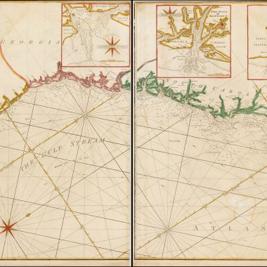
| 5 | THE COAST / OF / A PART OF NORTH CAROLINA, SOUTH / CAROLINA, GEORGIA AND PART OF / EAST FLORIDA, WITH THE / BAYS, SOUDINGS, BANKS, ROKS, SHOALS, CURRENTS, / and other NAUTICAL REMARKS, CORRECTET and / IMPROVED from the ORIGINAL MATERIALS / and the latest ACTUAL SURVEYS. / To be sold at AMSTERDAM bÿ G: H: van KEULEN. / ANNO 1784. [5e] 620 x 1105 Inset: 441 x 415mm. Extent: ‘CAPE HATTERAS’ – ‘Fort Intende’ south of ‘Matanza Inlet Fort’ | |
| 6 | A / NEW AND CORRECT CHART / OF THE / COAST OF EAST FLORIDA, / AND PART OF WEST FLORIDA AND GULF OF MEXICO, / ISLANDS OF LUCAYOS, BAHAMA BANKS AND MARTYRS, / WITH THE / SOUNDINGS, ROKS, BANKS, CURRENTS, SHOALS & NAUTICAL REMARKS, / COMPOSED FROMA [sic] GREAT NUMBER OF NEW ACTUAL SURVEYS AND OTHER / ORGIINAL MATERIALS, REGULATED AND CORRECTED BY ASTRO= / =NOMICAL OBSERVATIONS. / These Charts are Followed, according / tho them Executed by order of the / Lords Commissioners of the / Admiralty in England. / To be Sold at Amsterdam / by G: H: van Keulen. / 1784. [5a] 606 x 1142 Inset (ib): 180 x 180mm. Extent: ‘Mobile Bay’ on the Gulf coast to ‘Nassaw River’ on the Atlantic coast, with the Bahamas Islands |
The Editors would like to thank Jonathan Potter, of Jonathan Potter Ltd., for permission to collate the atlas, and reproduce the charts.
References:
Dr. I.C. Koeman Atlantes Neerlandici Vol. IV (Amsterdam: Theatrum Orbis Terrarum, 1970), Keu 143A
John R. Sellers and Patricia Molen van Ee Maps and Charts of North America and the West Indies 1750-1789 A Guide to the Collections in the Library of Congress (Washington: Library of Congress, 1981), no.219: ‘The Coast Of New Schotland …’