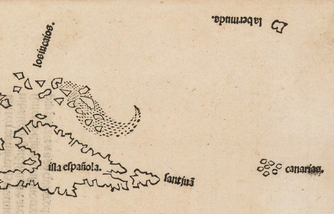
Bermuda is generally considered to have been named after the first European known to have visited the island-group, Juan de Bermudez, in 1505, when he was ship-wrecked while transporting hogs to Cuba. The first appearance of the island in a printed map – as ‘la bermuda’ – occurs in an untitled woodcut map of the West Indies found in Peter the Martyr’s Opera Legatio Babylonica Oceani Decas Poemata Epigrammata, published by Jacob Cromberger in 1511.
Peter the Martyr was tutor to the children of Ferdinand and Isabella of Spain, and has been described as the first historian of the Americas. He had extensive personal contacts with Spain’s explorers, such as Christopher Columbus, as well as access to official archives. His map, which is the first separate printed map devoted to the New World, was presumably copied from the relevant part of the ‘Padron Real’, the large map of the world on which the Spanish recorded all their discoveries. It is generally assumed that the authorities were unhappy that such an accurate map found its way into the public domain, and suppressed it almost immediately, as it is only rarely found with the book.
An anomaly in this very important map is that it shows a section of coast ‘illa de beimeni parte’, which is approximately in the right place to be the Florida peninsula. However, the European ‘discovery’ of the peninsula, by Juan Ponce de Leon, was in 1513, two years later, and this has been taken as an indication that the Spanish had access to additional geographical information supplied by Indian sources, from their own voyages through the region.
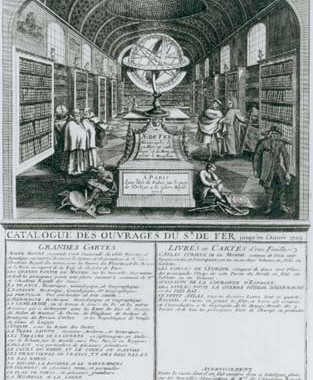
As this map is so rare (the author only knows of one example ever for sale), the earliest map to show Bermuda readily available for the collector is the Gastaldi of the New World, published 1548.

In 1609, Sir George Somers, while sailing to Virginia was also shipwrecked on the island, and its from him that the island got its alternative the ‘Somer’ or ‘Summer’ Islands. The arms of the island found on several of the maps in the checklist, not surprisingly, incorporate a shipwreck.
In 1612, the islands were granted to the Virginia Colony, and a settlement established there the following year. Subsequently, government passed to the Bermuda Company. However, government by the colony proved unsatisfactory, and in 1684, the islands reverted to Crown control.
The first English map of Bermuda was compiled by one of the settlers, Richard Norwood, in 1618, and this was used as the basis for the map of the islands published in John Smith’s The Generall Historie Of Virginia, New-England, And The Summer Isles (London, 1624).
In 1622, Norwood evidently made a second map of the island, and a entry in the Registers of the Stationers’ Company, for January 19th 1621 / 22 records:
Nathanael Newbury Entred for his copie vnder the hands of Master Doctor Goad, and Master Knight warden, A Plott or Mappe of Bermudas or the Summer Islands made by Richard Norwood.
Unfortunately, there is no known example of this map. Newbery, a mapseller and publisher working in Popes Head Alley in London, is not known as a publisher of maps, although he also entered a map of Bergen-op-Zoom in the Registers of the Stationer’s Company in 1622, of which I know of only one example. It is all too possible that the map of Bermuda was published, but all examples have been lost.
Clearly John Speed’s map of Bermuda, dated 1626, derives either from the manuscript or printed version, as the map shows “names of the now Adventurer, viz. this yeare 1622…”
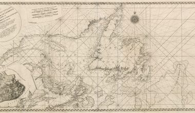
The earliest chart of the island was compiled by Arent Roggeveen, and published by Pieter Goos in 1675. The Speed and Roggeveen supply the two parallel delineations of the islands that were repeated by subsequent mapmakers, subsequently revised and updated throughout the early eighteenth century. Clement Lempriere’s chart, published in 1738, was the next major advance, and its influence is visible in subsequent maps and charts of the islands to the end of the century.

Checklist of Printed Maps of Bermuda
(1585 – 1778)
| 1 | 1585. Thevet, Andre [Untitled Map Of ‘LA BERMVDE’] Source: Thevet’s ‘Le Grand Insulaire’ [ca.1585]. 150 x 185 approx.mm. Separate publication. The plate was engraved for Thevet’s island book, which was never completed. The original manuscript is in the Bibliotheque Nationale, Paris, while groups of the engraved plates are found in various collections there, in the British Library, and the Huntingdon Library, California. The latter has the only known example of the Bermuda. The Map Collector, 74 (Spring 1996), p.30 (ill); | |
| 2 | 1624. Smith, John The Summer Ils. [3a] The description of y.e land / by M.r Norwood * / All contracted into this order / by Captaine Iohn Smith. [2e, ob] [One of 13 Sections, on one sheet, including 14 vignette views] ‘St. Catherins / forte’ [1a, ob] ‘Pembroks forte’ [2a, ob] ‘Kings Castell & Southampton forte’ [2a, ob – 4a, ob] ‘Devonshire Redoute’ [5a, ob] ‘St. George Town [olb] ‘Warwicks forte’ [olb] ‘Riches Mount’ [orb] ‘The 3 / Bridges’ [orb] ‘State House.’ [1e, ob] ‘Smiths forte’ ‘Pagets forte’ [2e, ob – 4e, ob] [Penistons Redoute] [4e, ob] ‘Charles forte’ [5e] Source: Smith Generall Historie 1624 1. 110 x 140 B: 280 x 345mm. State 1: The engraving of ‘Penistons Redoute’ is untitled. | |
| 3 | 1624 [1624]. Smith, John The Summer Ils. [3a] The description of y.e land / by M.r Norwood * / All contracted into this order / by Captaine Iohn Smith. [2e, ob] [One of 13 Sections, on one sheet, including 14 vignette views] ‘St. Catherins / forte’ [1a, ob] ‘Pembroks forte’ [2a, ob] ‘Kings Castell & Southampton forte’ [2a, ob – 4a, ob] ‘Devonshire Redoute’ [5a, ob] ‘St. George Town [olb] ‘Warwicks forte’ [olb] ‘Riches Mount’ [orb] ‘The 3 / Bridges’ [orb] ‘State House.’ [1e, ob] ‘Smiths forte’ ‘Pagets forte’ [2e, ob – 4e, ob] ‘Penistons Redoute’ [4e, ob] ‘Charles forte’ [5e] Source: Smith Generall Historie 1624 1. 110 x 140 B: 280 x 345mm. State 2: The engraving of ‘Penistons Redoute’ is now so titled. | |
| 4 | 1624 [1624]. Smith, John The Summer Ils. [3a] The description of y.e land / by M.r Norwood * / All contracted into this order / by Captaine Iohn Smith. [2e, ob] [One of 13 Sections, on one sheet, including 14 vignette views] ‘St. Catherins / forte’ [1a, ob] ‘Pembroks forte’ [2a, ob] ‘Kings Castell & Southampton forte’ [2a, ob – 4a, ob] ‘Devonshire Redoute’ [5a, ob] ‘St. George Town [olb] ‘Warwicks forte’ [olb] ‘Riches Mount’ [orb] ‘The 3 / Bridges’ [orb] ‘State House.’ [1e, ob] ‘Smiths forte’ ‘Pagets forte’ [2e, ob – 4e, ob] ‘Penistons Redoute’ [4e, ob] ‘Charles forte’ [5e] Source: Smith Generall Historie 1624 1. 110 x 140 B: 280 x 345mm. State 3: Reeve’s imprint has been egraved at the bottom of the vignette of ‘Charles forte’ [5e, ob] | |
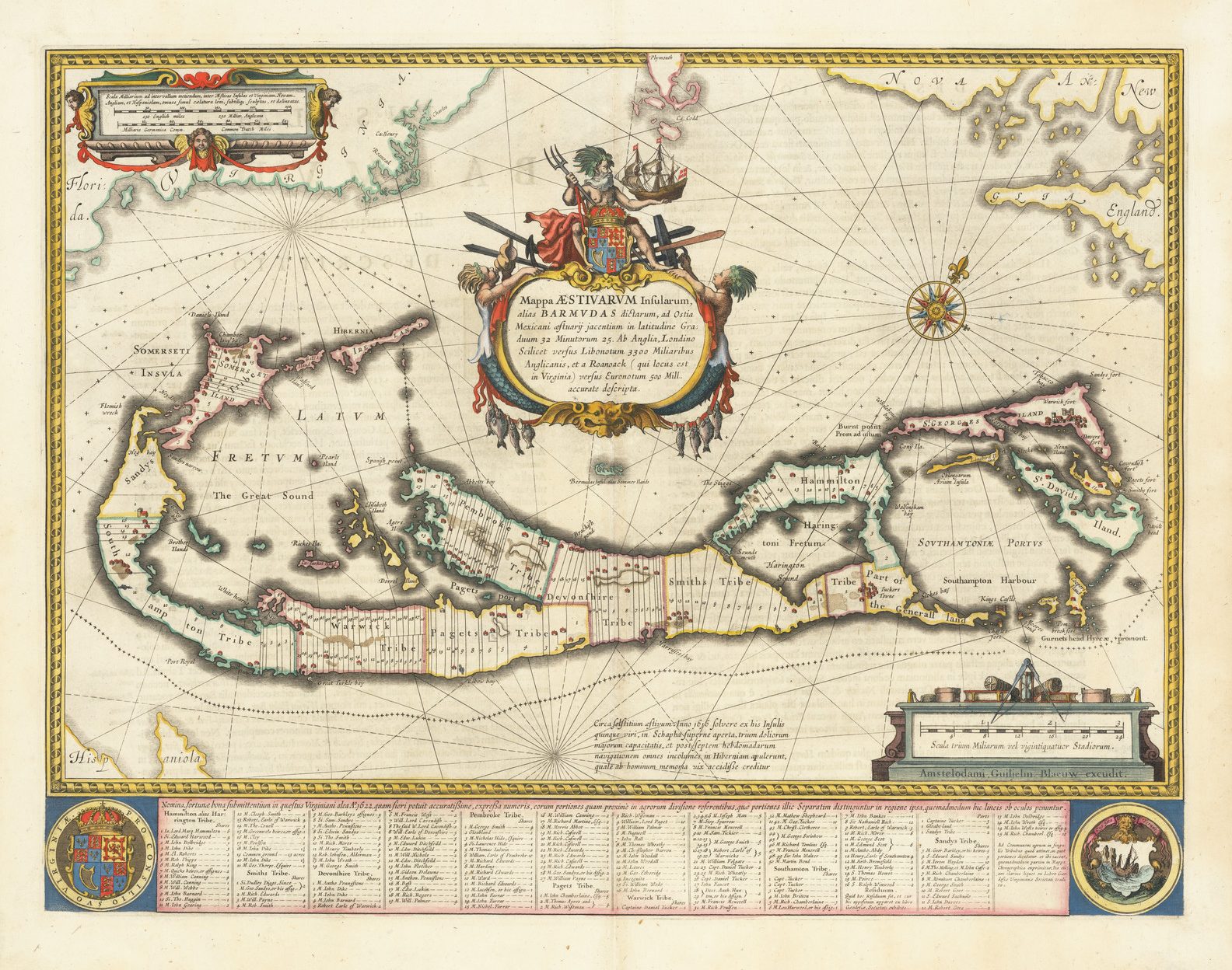
| 5 | 1626. Speed, John Mappa / ÆSTIVARUM / Insularum alias Bermudas / dictarum, ad ostia Mexica= / ni æstuarij iacentium in La= / titudine Graduum 32: Mi= / nutorum 25. Ab Anglia, / Londino Scilicet versus Libo= / notum 3300 Miliaribus An= / glicanis, et a Roanoack (qui / locus est in Virginia) versus / Euro=notum 500 Mil. accurate descr. // A Mapp of the / SOMMER / Ilands once called the / Bermudas Lying at the mouth / of the bay of Mexico. in the / Lattitude of 32. degr: 25. mi: / Distant from England viz. from / London toward the west south- / -west 3300 miles And from / Roanoack in Virginia to= / ward the east south east / 500. miles exactlie Surveyed. [3b] Abraham Goos Amstelodamensis sculpsit. [4e] Source: Speed Prospect: Proof. 352 x 537 B: 402 x 537mm. There is evidence that this map was sold separately by Goos, prior to the addition of Humble’s imprint. It seems plausible that Humble’s imprint may have been added in England. | |
| 6 | 1626 [1627]. Speed, John Mappa / ÆSTIVARUM / Insularum alias Bermudas / dictarum, ad ostia Mexica= / ni æstuarij iacentium in La= / titudine Graduum 32: Mi= / nutorum 25. Ab Anglia, / Londino Scilicet versus Libo= / notum 3300 Miliaribus An= / glicanis, et a Roanoack (qui / locus est in Virginia) versus / Euro=notum 500 Mil. accurate descr. // A Mapp of the / SOMMER / Ilands once called the / Bermudas Lying at the mouth / of the bay of Mexico. in the / Lattitude of 32. degr: 25. mi: / Distant from England viz. from / London toward the west south- / -west 3300 miles And from / Roanoack in Virginia to= / ward the east south east / 500. miles exactlie Surveyed. [3b] Source: Speed Prospect 1627 1. 352 x 537 B: 402 x 537mm. | |
| 7 | 1626 [1662]. Speed, John Mappa / ÆSTIVARUM / Insularum alias Bermudas / dictarum, ad ostia Mexica= / ni æstuarij iacentium in La= / titudine Graduum 32: Mi= / nutorum 25. Ab Anglia, / Londino Scilicet versus Libo= / notum 3300 Miliaribus An= / glicanis, et a Roanoack (qui / locus est in Virginia) versus / Euro=notum 500 Mil. accurate descr. // A Mapp of the / SOMMER / Ilands once called the / Bermudas Lying at the mouth / of the bay of Mexico. in the / Lattitude of 32. degr: 25. mi: / Distant from England viz. from / London toward the west south- / -west 3300 miles And from / Roanoack in Virginia to= / ward the east south east / 500. miles exactlie Surveyed. [3b] Source: Speed Prospect 1627 7. 352 x 537 B: 402 x 537mm. | |
| 8 | 1626 [1676]. Speed, John Mappa / ÆSTIVARUM / Insularum alias Bermudas / dictarum, ad ostia Mexica= / ni æstuarij iacentium in La= / titudine Graduum 32: Mi= / nutorum 25. Ab Anglia, / Londino Scilicet versus Libo= / notum 3300 Miliaribus An= / glicanis, et a Roanoack (qui / locus est in Virginia) versus / Euro=notum 500 Mil. accurate descr. // A Mapp of the / SOMMER / Ilands once called the / Bermudas Lying at the mouth / of the bay of Mexico. in the / Lattitude of 32. degr: 25. mi: / Distant from England viz. from / London toward the west south- / -west 3300 miles And from / Roanoack in Virginia to= / ward the east south east / 500. miles exactlie Surveyed. [3b] Source: Speed Prospect 1627 8. 352 x 537 B: 402 x 537mm. | |
| 9 | 1630. Blaeu, Willem Jansz. Mappa ÆSTIVARUM Insularum, / alias BARMVDAS dictarum, ad Ostia / Mexicani æstuarij jacentium in latitudine Gra= / duum 32 Minutorum 25. Ab Anglia, Londino / Scilicet versus Libonotum 3300 Miliaribus / Anglicanis, et a Roanoack / (qui locus est / in Virginia) versus Euronotum 500 Mill. / accurate descripta. [3b] Amstelodami, Guiljelm. Blaeuw excudit. [5e] Source: Blaeu ‘Atlantis Appendix’ 1630. B: 400 x 530mm. | |
| 10 | 1630. Cloppenburgh, Johannes Mappa / ÆSTIVARVM / Insularum alias Bermudas dictarum ad ostia / Mexicane æstuarij iacentium in Latitudine Graduum / 32 Minutorum 25. Ab Anglia, Londino Scilicet / versus Libonotum 3300 Miliaribus Anglicanis et / a Roanoack (quilocus est in Virginia) versus Euo / notum 500 Mill. acurate descripta. [4e] Source: Cloppenburgh ‘Gerardi Mercatoris Atlas’ 1630. 189 x 257mm. | |
| 11 | 1630 [1738 ca]. Cloppenburgh, Johannes Mappa / ÆSTIVARVM / Insularum alias Bermudas dictarum ad ostia / Mexicane æstuarij iacentium in Latitudine Graduum / 32 Minutorum 25. Ab Anglia, Londino Scilicet / versus Libonotum 3300 Miliaribus Anglicanis et / a Roanoack (quilocus est in Virginia) versus Euo / notum 500 Mill. acurate descripta. [4e] 262 [5a] Source: Henri du Sauzet ‘Atlas Portatif [1738]. 189 x 257mm. | |
| 12 | 1630. Laet, Johannes Bermuda majori mole expressa’ [5d [4d/e-5d/e] [Inset on] NOVA ANGLIA, / NOVVM BELGIVM / ET VIRGINIA. [1b] Source: Laet ‘Beschrijvinghe Van West Indien’ 1630. 90 x 90mm. | |
| 13 | 1633. Hondius, Hendrick Mappa ÆSTIVARUM Insularum, / alias BARMVDAS dictarum, ad Ostia / Mexicani æstuarij jacentium in latitudine Gra= / duum 32 Minutorum 25. Ab Anglia, Londino / Scilicet versus Libonotum 3300 Miliaribus / Anglicanis, et a Roanoack (qui locus est / in Virginia) versus Euronotum 500 Mill. / accurate descripta. [3b] Amstelodami, Apud Henricum Hondium. [5e] Source: Hondius ‘Atlas Ou Representation Du Monde’ 1633. B: 390 x 520mm. | |
| 14 | 1633 [1647]. Hondius, Hendrick Mappa ÆSTIVARUM Insularum, / alias BARMVDAS dictarum, ad Ostia / Mexicani æstuarij jacentium in latitudine Gra= / duum 32 Minutorum 25. Ab Anglia, Londino / Scilicet versus Libonotum 3300 Miliaribus / Anglicanis, et a Roanoack (qui locus est / in Virginia) versus Euronotum 500 Mill. / accurate descripta. [3b] Amstelodami, Apud Ioannem Ianssonium [5e] Source: Jansson ‘Atlas Novus’ 1647. B: 390 x 520mm. | |
| 15 | 1633 [1710 ca]. Hondius, Hendrick Mappa ÆSTIVARUM Insularum, / alias BARMVDAS dictarum, ad Ostia / Mexicani æstuarij jacentium in latitudine Gra= / duum 32 Minutorum 25. Ab Anglia, Londino / Scilicet versus Libonotum 3300 Miliaribus / Anglicanis, et a Roanoack (qui locus est / in Virginia) versus Euronotum 500 Mill. / accurate descripta. [3b] Prostant Amstelodami, apud P. SCHENK, et G. VALK. C.P. [5e] Source: Schenk & Valk Composite Atlases. B: 390 x 520mm. | |
| 16 | 1635. Anonymous Mappa / ÆSTIVARVM / Insularum alias Bermudas dictarum ad Ostia / Mexicane æstuarij iacentium in Latitudine Graduum / 32 Munitorum 25 Ab Anglia. Londino Scilicet / versus Libonotum 3300 Miliaribus Anglicanis et / a Roanoak (qui locus est in Virginia) versus / Euro notum 500 Mil. acurate descr. [4e] [set in text] ‘919’ ‘A DESCRIPTION OF/ THE SUMMER ILANDS.’ Source: Mercator-Mini Historia Mundi 1635 1. 165 x 230mm. | |
| 17 | 1659. Duval, Pierre Isles Bermudes. [5a] Inset on: LA / VIRGINIE / Par P. Duval Geogra: / du Roy / A PARIS / 1659. [5c] Source: Duval ‘Le Monde Terrestre’ 1660. 14 x 15 Map: 97 x 121mm. The map is known in a number of later states, but the inset itself is unaltered. | |
| 18 | 1671. Montanus, Arnold Mappa AESTIVARUM Insularum / alias BARMVDAS dictarum, ad Ostia Mexi- / cani aestuarij jacentium in latitudine Graduum 32 / Minutorum 15. Ab Anglia, Londino Scilicet versus / Libonotum 3300 Miliaribus Anglicanis, et a / Roanoack (qui locus est in Virginia) versus / Euronotum 500 Mill. accurate descripta. [3b] Source: Montanus ‘De Nieuwe En Onbekende Weereld’ 1671. 233 x 352 Border: 288 x 352mm. The map was re-issued in Ogilby’s ‘America’, London, 1671, and Montanus’ ‘De Unbekante Neue Welt’, Amsterdam, 1673; the English edition can be distinguished by the paper used, which generally has a cockatrice watermark, while the Dutch printings generally have a jester’s head watermark. | |
| 19 | 1671. Montanus, Arnold BERMUDES, / ou / ILES DE SOMMER, / dans l’ / AMERIQUE SEPTENTRIONALE / avec le Registre des departements de ce Pays / aux peuplades / ANGLOISES, / donnée nouvellement au Public par / PIERRE VANDER AA / Marchand Libraire / À LEIDE. [3a] Source: Pieter van der Aa ‘La Galerie Agreable’ 1729. 233 x 352 Border: 288 x 352mm. State 2: printed from the Montanus plate, but so heavily re-engraved as to be almost unrecognisable. | |
| 20 | 1675. Roggeveen, Arent Pascaerte van / ‘t Eÿland la Bermuda / of / Sommer Ilands / en de andere Eÿlanden daer / bÿ geleeghen. [2b] 30 [5d] Source: Roggeveen ‘Het Brandende Veen’ 1675. 409 x 513 PM: 421 x 521mm. | |
| 21 | 1675 [1689]. Roggeveen, Arent Pascaerte van / ‘t Eÿland la Bermuda / of / Sommer Ilands / en de andere Eÿlanden daer / bÿ geleeghen. / Robyn ex. [2b] 30 [5d] Source: Robijn ‘Het Brandende Veen’ [1689]. 409 x 513 PM: 421 x 521mm. | |
| 22 | 1675 [1717]. Roggeveen, Arent Pascaerte van / ‘t Eÿland la Bermuda / of / Sommer Ilands / en de andere Eÿlanden daer / bÿ geleeghen. / I. Loots exc. [2b] 30 [5d] Source: Loots ‘New Great Sea-Mirrour’ 1717. 409 x 513 PM: 421 x 521mm. | |
| 23 | 1678. Duval, Pierre Isles Bermudes. [5a] Inset on: VIRGINIE. [5c] VIRGINIA et Insulæ BERMVDES [2a – 4a, in border] 75 [5a, in border] Source: [Duval] ‘Geographiae Unversalis’ 1678. 14 x 15 Map: 96 x 120mm. | |
| 24 | 1680. Morden, Robert ÆSTIVARUM / INSULÆ / al’ / BARMUDAS / Lat. 32.D 25.m / 3300 miles from / London / 500 from Roanoak in / Virginia by R. Morden. [2e] Source: Morden Geography Rectified 1680 1a. B: 107 x 132 PM: 109 x 135mm. | |
| 25 | 1682. Keulen, Johannes van Pas Kaart / Van / I. LA BARMUDA / Anders / SOMMER ILANDS / int Groot Door CIVoght Geometra / T’AMSTERDAM By / JOHANNES VAN KEULEN / Boek en Zee Kaart verkooper aande Niewe Brug / Inde Gekroonde Lootsman / Met Privilegie voor 15 Iaaren. [1b] Source: Van Keulen’s ‘Zee-Fakkel’ [1684]. 520 x 605mm. | |
| 26 | 1682 [1687]. Keulen, Johannes van Pas Kaart / Van / I. LA BARMUDA / Anders / SOMMER ILANDS / int Groot Door CIVoght Geometra / T’AMSTERDAM By / JOHANNES VAN KEULEN / Boek en Zee Kaart verkooper aande Niewe Brug / Inde Gekroonde Lootsman / Met Privilegie voor 15 Iaaren. [1b] 17 [1e] Source: Van Keulen’s ‘Zee-Fakkel’ 1687. 520 x 605mm. State 2: with the addition of the plate number ’17’ in the lower left corner. | |
| 27 | 1682 [1702]. Keulen, Johannes van Pas Kaart / Van / I. LA BARMUDA / Anders / SOMMER ILANDS / int Groot Door CIVoght Geometra / T’AMSTERDAM By / JOHANNES VAN KEULEN / Boek en Zee Kaart verkooper aande Niewe Brug / Inde Gekroonde Lootsman / Met Privilegie voor 15 Iaaren. [1b] 17 [1e] 17 [4d] Source: Van Keulen’s ‘Zee-Fakkel’ 1702. 520 x 605mm. State 3: with the addition of the second plate number ’17’ above the scale bar. | |
| 28 | 1682. Seller, John Sr. BERMUDAS / al’ / Summer Islands / Lat: 32.d- 25.m / Long from p Tenneriff / .d 310-0.m / by Iohn Seller. [2a] Source: Seller Atlas Maritimus [Pocket] 1682 1. 108 x 133 PM: 115 x 141mm. | |
| 29 | 1688. Anonymous Les BARMUDES. [3a] Source: [Richard Blome] ‘L’Amerique Angloise’. 100 x 125mm. Copied from Morden’s map, as used in Richard Blome’s ‘Present State Of his Majesties Island And Territories In America’, London, 1687. This version was subsequently copied by Chatelain, in 1719. | |
| 30 | 1688. Morden, Robert ÆSTIVARUM / INSULÆ / al’ / BARMUDAS / Lat. 32.D 25.m / 3300 miles from / London / 500 from Roanoak / in Virginia, by R. Morden. [3e] Source: Morden Geography Rectified 1680 2. 103 x 130 PM: 107 x 135mm. | |
| 31 | 1688 [1693]. Morden, Robert ÆSTIVARUM / INSULÆ / al’ / BARMUDAS / Lat. 32.D 25.m / 3300 miles from / London / 500 from Roanoak / in Virginia, by R. Morden. [3e] Source: Morden Geography Rectified 1680 3. 103 x 130 PM: 107 x 135mm. State 2: with the page number inserted. | |
| 32 | 1689. Thornton, John The Iland of / BERMUDAS / North Latt: 32:d 25.’ [2d] Source: English Pilot. Fourth Book 1 1689 Copy 1. W: 424 x 257 B: 422 x 519mm. | |
| 33 | 1689 [1716]. Thornton, John [‘BERMUDAS’] Source: English Pilot. Fourth Book 6 1716 Copy 1. 222 x 290 PM: 224 x 294mm. State 2: The copperplate has been cut down, to create two separate, and smaller, maps. The Bermuda map is now without title, with a new scale bar inserted above the island, and a new compass rose to show north. | |
| 34 | 1692. Duval, Pierre Isles Bermudes. [5e] Inset on: [Untitled Map Of Virginia] Source: Muller ‘Kurt Bündige … Gantzen Welt’ 1692. 14 x 15 Map: 96 x 120mm. The map is known in two states, each also having the text below reset, but the inset of Bermuda is unchanged. The illustrated example is the second state. | |
| 35 | 1692. Coronelli, Vincenzo Maria LE BERMUDE, / Dedicate / All’Illustrrissimo Sig:r Abbate / Isodoro Bernardi. [4d] Source: Coronelli ‘Atlante Veneto’ 1692. 225 x 298mm. One of four maps on one sheet. | |
| 36 | 1696. Lea, Philip [Untitled Map Of ‘BERMUDAS’] [1b/c – 2b/c] [on sheet entitled] THE PRINCIPALL ISLANDS IN AMERICA BELONGING TO THE ENGLISH EMPIRE VIZ IAMAICA / BARBADOS, ANTEGOA, S.T CHRISTOPHERS, & BERMUDOS. Sold by Philip Lea at the Atlas and Hercules in Cheapside. [1a, ob – 5a, ob] Source: Lea, Philip Separate publication. B: 470 x 560mm. | |
| 37 | 1696 [1732 ca]. Lea, Philip [Untitled Map Of ‘BERMUDAS’] [1b/c – 2b/c] [on sheet entitled] THE PRINCIPALL ISLANDS IN AMERICA BELONGING TO THE ENGLISH EMPIRE VIZ IAMAICA / BARBADOS, ANTEGOA, S.T CHRISTOPHERS, & BERMUDOS. / { Sold by Geo: Willdey at the Great Toy, Spectacle, China-Ware and Print shop at the Corner of Ludgate / { Street near S.t Pauls London. [1a, ob – 5a, ob] Source: Willdey, George Separate publication. B: 470 x 560mm. State 2: with Willdey’s imprint substituted in the sheet title. | |
| 38 | 1696. Browne, Christopher [‘BERMUDOS’] [1b/c – 2b/c] [on sheet entitled] A NEW MAP OF THE ENGLISH EMPIRE IN THE OCEAN OF AMERICA OR / WEST INDIES. Sold by Chr. Browne at the Globe near the West end of S.t Pauls Church. London. [2a, ob – 4a, ob] I. Harris sculp. [4b] Source: Browne Separate publication. B: 505 x 605mm. | |
| 39 | 1696 [1721]. Browne, Christopher [‘BERMUDOS’] [1b/c – 2b/c] [on sheet entitled] A NEW MAP OF The ENGLISH EMPIRE IN The OCEAN OF AMERICA OR / WEST INDIES. Revis’d by I. Senex. [2a, ob – 4a, ob] I. Harris sculp. [4b] Source: Senex New General Atlas 1721. B: 505 x 605mm. | |
| 40 | 1700. Wells, Edward A NEW MAP Of the most Considerable / PLANTATIONS Of the ENGLISH / In AMERICA / Dedicated to His Highness / William Duke of Glocester. [2b] Sutton Nicholls sculp. [5e] Source: Wells Sett Of Maps 1700 1. 351 x 479 PM: 370 x 495mm. | |
| 41 | 1700 [1701]. Wells, Edward A NEW MAP Of the most Considerable / PLANTATIONS Of the ENGLISH / In AMERICA / Dedicated to His Highness / William Duke of Glocester. [2b] Sutton Nicholls sculp. [5e] Source: Wells Sett Of Maps 1700 2. 351 x 479 PM: 370 x 495mm. | |
| 42 | 1700. Lea, Philip [Untitled Map Of ‘BERMUDAS’] [1d/e – 5c/e] [on an untitled sheet with a map of Antigua] Source: Lea Hydrographia Universalis [ca. 1700]. B: 210 x 165mm. | |
| 43 | 1703. Seller, Jeremiah & Price, Charles [Bermuda] [1b/c – 2b/c] [on sheet entitled] A Chart of / The Islands of / JAMAICA BARBADOS / S.T CHRISTOPHER / MARTINECO ANTEGOA / & BERMUDAS. / [Seller and Price imprint]. [4d] Antigua: 122 x 180 St. Kitts: 163 x 167 Barbados 214 x 147 Bermuda: 214 x 174 Martinique: 169 x 165 Jamaica: 210 x 523 Source: Seller & Price English Pilot Book Four 1703. 143 x 180mm. | |
| 44 | 1703 [1707]. Seller, Jeremiah & Price, Charles [Bermuda] [1b/c – 2b/c] [on sheet entitled] A Chart of / The Islands of / JAMAICA BARBADOS / S.T CHRISTOPHER / MARTINECO ANTEGOA / & BERMUDAS. / [erasure]. [4d] Antigua: 122 x 180 St. Kitts: 163 x 167 Barbados 214 x 147 Bermuda: 214 x 174 Martinique: 169 x 165 Jamaica: 210 x 523 Source: English Pilot. Fourth Book 4 1707 Copy 1. 143 x 180 B: 427 x 523 PM: 432 x 527mm. | |
| 45 | 1706. AA, Pieter van der DE / BERMUDES / of / SUMMER / EYLANDEN / tot de / REYSTOGTEN / afgepeyld, door de / ENGELZEN / derwaards gedaan. [5d] Ellis [5e, ob] Pag.5. [5a, ob] Uytgevoerd te LEYDEN door PIETER VANDER AA met Privilegie. [1e, ob] Source: Aa ‘Kort Bericht Van M.r Ellis’ 1706. 148 x 230mm. This volume forms part of van der Aa’s collection of travels, ‘Naaukeurige Versameling Der Gedenk-Waardigste Zee En Landreysen Na Oost En West-Indies …’, published from 1707 onwards. | |
| 46 | 1706 [1707]. AA, Pieter van der DE / BERMUDES / of / SUMMER / EYLANDEN / tot de / REYSTOGTEN / afgepeyld, door de / ENGELZEN / derwaards gedaan. [5d] Ellis [5e, ob] [5a, ob] Uytgevoerd te LEYDEN door PIETER VANDER AA met Privilegie. [1e, ob] Source: Aa ‘Cartes Des Itineraires’ [1707]. 148 x 230mm. State 2: the map has had the page number erased, and is now printed set with a frame border printed from a second plate. | |
| 47 | 1706 [1714]. AA, Pieter van der DE / BERMUDES / of / SUMMER / EYLANDEN / tot de / REYSTOGTEN / afgepeyld, door de / ENGELZEN / derwaards gedaan. [5d] Source: Aa ‘Atlas Nouveau’ [1714]. 148 x 230mm. State 3: van der Aa’s imprint outside the lower border has ben erased, and replaced by a second title, in French. | |
| 48 | 1707. Coronelli, Vincenzo Maria I: BREMUDE. [5e] Source: Coronelli ‘Isole Britanniche’ [ca. 1707]. 125 x 272mm. | |
| 49 | 1708. Moll, Herman A Map of y.e Island of / BERMUDOS. / Divided into its Tribes, w.th / the Castles, Forts &c. By H. M. [3c] Vol.1. Pag. 325 [1a, ob] Source: Oldmixon British Empire 1708 1. 176 x 100 B: 183 x 260mm.1708. Moll, Herman A Map of y.e Island of / BERMUDOS. / Divided into its Tribes, w.th / the Castles, Forts &c. By H. M. [3c] Vol.1. Pag. 325 [1a, ob] Source: Oldmixon British Empire 1708 1. 176 x 100 B: 183 x 260mm. | |
| 50 | 1708 [1741]. Moll, Herman A Map of y.e Island of / BERMUDOS. / Divided into its Tribes, w.th / the Castles, Forts &c. By H. M. [3c] Source: Oldmixon British Empire 1708 2. 176 x 100 B: 183 x 260mm. State 2: with the page number erased from outside the upper border. | |
| 51 | 1708 [1750 ?]. Moll, Herman A Map of y.e Island of / BERMUDOS. / Divided into its Tribes, w.th / the Castles, Forts &c. By H. M. [3c; 3a/e – 5a/e] 53 [5a] Source: [?]. 176 x 100 B: 183 x 260mm. State 3: with the plate number 53 engraved in the top right hand corner of the Bermudas map. | |
| 52 | 1708 [1781]. Moll, Herman A Map of y.e Island of / BERMUDOS. / Divided into its Tribes, w.th / the Castles, Forts &c. By H. M. [3c; 3a/e – 5a/e] 53 [5a] Source: Moll Atlas Minor [1781]. 176 x 100 B: 183 x 260mm. State 4: with Carington Bowles’ imprint inserted under the title cartouche of the Carolinas map. | |
| 53 | 1719. Chatelain, Henri-Abraham Les / BARMUDES. / Lat. 32. Degres 25 / minutes. [3a] [on sheet entitled] CARTE QUI CONTIENT UNE DESCRIPTION DES ILES & TERRES QUE LES ANGLOIS POSSEDENT DANS L’AMERIQUE SEPTENTRIONALE, ET EN PARTICULIER DE LA JAMAIQUE / DES ISLES BARBADES, DE LA NOUVELLE ANGLETERRE, DES BARMUDES, de la CAROLINE, de la PENSILVANIE, Et du NEW-FOUNDLAND, AVEC UN ETAT DE CHAQUE PAÏS, DU TEMS DE SA DECOUVERTE, DE SES DIFFERENTES PRODUCTIONS, et de la NATURE du COMMERCE QUI S’Y FAIT. / Tom. VI. N.o 26. Pag: 100 Source: Chatelain ‘Atlas Historique’ Vol. VI 1719. 70 x 94 with text: 117 x 126 B: 392 x 522mm. | |
| 54 | 1721. Kyzer, J. [Keizer] DE BERMUDAS / EYLANDEN / Verdeelt in deszelfs Wycken / door / H. Mol. [4c; 4a/e – 5a/e] ‘I. Deel. Blaz. 249. [3a, ob] [on sheet with a map of the Carolinas, which contains Kyser’s signature] Source: [Oldmixon] ‘Het Britannische Ryk In Amerika’ 1721. 176 x 100mm. | |
| 55 | 1728. Cutler, Nathaniel BERMUDAS [3a/3c – 5a/c] 48 [5e, ob] Source: Defoe Atlas Maritimus 1728. 281 x 265 B: 488 x 580 PM: 510 x 607mm. | |
| 56 | 1729. Moll, Herman The Island of / BERMUDOS / Divided into its Tribes, with / the Castles Forts &c. / By H. Moll Geographer 1729. [3a] [On sheet with a map of part of Providence Island] Source: Moll Atlas Minor 1729 1. B: 200 x 270mm. | |
| 56a | 1729. Moll, Herman The Island of / BERMUDOS / Divided into its Tribes, with / the Castles Forts &c. / By H. Moll Geographer. [3a] [On sheet with a map of part of Providence Island] State 2: with the plate number ’53’ added [5a, ob] the date has been erased from the title. | |
| 57 | 1729 [1736 ?]. Moll, Herman The Island of / BERMUDOS / Divided into its Tribes, with / the Castles Forts &c. / By H. Moll Geographer. [3a] [On sheet with a map of part of Providence Island] Source: Moll Atlas Minor [1736 ?]. B: 200 x 270mm. | |
| 58 | 1737. Homann’s Heirs Insulæ BERMUDES / in suas Tribus divisæ, cum / omnibus Castellis et Fortali- / tijs, secundum exemplar Lon- / dinense delineatæ. [2d; 1d/e – 3d/e] [on sheet entitled] DOMINIA ANGLORUM / in præcipuis Insulis AMERICÆ / ut sunt Insula / S. CHRISTOPHORI / ANTEGOA / IAMAICA / BARBADOS / ex Insulis / Antil- / licanis nec non Insulæ BERMUDESvel SOMERS dictæ, singualri mappa omnia exhibita et edita ab Homannianis Heredibus. // Die ENGLISCHE COLONIE-LÆNDER / Auf den Insuln von AMERICA / und zwar die Insuln S. CHRISTOPHERI / ANTEGO / IAMAICA / BARBADOS / alles An- / tillische Insuln samt den Ins: BERMUDES sonst SOMMERS genant auf einem besondern / Blat saemtle vorgestellet in heraus gegeben von Homaennischen Erben. Source: Homann’s Heirs ‘Grosser Atlas [1737]. 118 x 280 B: 490 x 560mm. | |
| 59 | 1738. Lempriere, Clement [Untitled Map Of Bermuda] To his Excellency / Alured Popple Esq. / Governour of Bermuda, or the Summer Islands / This Map / From a new Survey, Correcting y.e Dangerous Errors / in all y.e CHARTS of that Place hitherto Publish’d / Is humbly Dedicated by / C. Lempriere, and W.H. Toms. 1738. [2a] C. Lempriere Delin. W.H. Toms Sculp. Price 2.s [5e, ob] Publish’d by C. Lempriere, & W.H. Toms Octo.br the 23.d 1738. [4e, ob] Source: Toms Separate publication. 345 x 518 B: 395 x 518mm. | |
| 60 | 1738 [1740 ?]. Lempriere, Clement [Untitled Map Of Bermuda] To his Excellency / Alured Popple Esq. / Governour of Bermuda, or the Summer Islands / This Map / From a new Survey, Correcting y.e Dangerous Errors / in all y.e CHARTS of that Place hitherto Publish’d / Is humbly Dedicated by / C. Lempriere, and W.H. Toms. 1738. [2a] Price 2.s [5e, ob] Publish’d by C. Lempriere, & W.H. Toms Octo.br the 23.d 1738. [4e, ob] Source: Toms Separate publication. 345 x 518 B: 395 x 518mm. State 2: described by Palmer thus: “Price 2 shillings without the imprint of Hardings [sic !] and Toms”, but not seen. | |
| 61 | 1741. Anonymous … BERMUDOS … Source: [Oldmixon ‘Das Britisch Reich In America’ 1744. mm. Not seen, but apparently a German copy of Herman Moll map, found in the 1741 edition of Oldmixon. | |
| 62 | 1746. Le Rouge LA BERMUDE / aux Anglois. [3d; 1c/e – 5c/e] [on sheet with] LA JAMAIQUE / aux Anglois dans le / Golfe du MEXIQUE / APARIS / Chez le S.r le Rouge 1746. [4a; 1a/c – 5a/c] 87 [5a, orb] Source: Le Rouge ‘Atlas Nouveau Portatif’ 1747. B: 200 x 265mm. | |
| 63 | 1746 [1767]. Le Rouge LA BERMUDE / aux Anglois. [3d; 1c/e – 5c/e] [on sheet with] LA JAMAIQUE / aux Anglois dans le / Golfe du MEXIQUE / APARIS / Chez le S.r Crepy 1767. [4a; 1a/c – 5a/c] 87 [5a, orb] Source: Crepy ‘Atlas Nouveau Portatif’ 1767. B: 200 x 265mm. | |
| 64 | 1747. Bowen, Emanuel A NEW & ACCURATE MAP / of / BERMUDAS / or / SOMMER’S ISLANDS, / taken from an / Actual Survey; / wherein the Errors of / former Charts / are Corrected / By Eman. Bowen. [1e; 1a/e – 3a/e] N.o 72 [on sheet with AN ACCURATE MAP of the ISLAND of S.T CHRISTOPHER, vulgarly called S.T KITS. Containing all the towns, Parishes, Forts &c. By Eman. Bowen. Source: Bowen ‘Complete System Of Geography’ 1747. 352 x 218 B: 354 x 438mm. | |
| 65 | 1747 [1752]. Bowen, Emanuel A NEW & ACCURATE MAP / of / BERMUDAS / or / SOMMER’S ISLANDS, / taken from an / Actual Survey; / wherein the Errors of / former Charts / are Corrected / By Eman. Bowen. [1e; 1a/e – 3a/e] N.o 64 [on sheet with] AN ACCURATE MAP of the ISLAND of S.T CHRISTOPHER, vulgarly called S.T KITS. Containing all the towns, Parishes, Forts &c. By Eman. Bowen. Source: Bowen ‘A Complete Atlas’ 1752. 352 x 218 B: 354 x 438mm. State 2: with the plate number altered. | |
| 66 | 1749. Grierson, George {Untitled Map Of The ‘BERMUDAS’] Source: Grierson ‘English Pilot. The Fourth Book’ 1749. 227 x 290mm. The Dublin piracy of the ‘Fourth Book’; in the Dublin editions the chart is printed set in text on page 52, while in the London editions it is found on page 50. | |
| 67 | 1763. Bellin, Jacques-Nicolas CARTE DES / ISLES BERMUDES / OU DE / SOMMER / Tiré de l’Anglois. [3a] Source: Bellin ‘Petit Atlas François’ 1763. 202 x 327mm. | |
| 68 | 1763 [1764]. Bellin, Jacques-Nicolas CARTE DES / ISLES BERMUDES / OU DE / SOMMER / Tiré de l’Anglois. [3a] Tome I. N.o 48 [5a, ob] Source: Bellin ‘Petit Atlas François’ 1763. 202 x 327mm. State 2: with the addition of the plate number. | |
| 69 | 1775. Jefferys, Thomas THE / BERMUDAS, / OR / SOMMER’S ISLANDS. / FROM A SURVEY / by / C. Lempriere. / regulated by Astronomical Observations. / London Printed for Rob.t Sayer, Map & Printseller, N.o 53 in Fleet Street. / as the Act directs 20 Feb.y 1775. [2b] F Source: Jefferys ‘West-India Atlas’ 1775. 450 x 595mm. | |
| 70 | 1775 [1787]. Jefferys, Thomas THE / BERMUDAS, / OR / SOMMER’S ISLANDS. / FROM A SURVEY / by / C. Lempriere. / regulated by Astronomical Observations. / London Printed for Rob.t Sayer, Map & Printseller, N.o 53 in Fleet Street. / as the Act directs 20 Feb.y 1787. [2b] F Source: Jefferys ‘Pilot For The West Indies’ [1788]. 450 x 595mm. | |
| 71 | 1775 [1794]. Jefferys, Thomas THE / BERMUDAS, / OR / SOMMER’S ISLANDS. / FROM A SURVEY / by / C. Lempriere. / regulated by Astronomical Observations. / [with the imprint of Laurie and Whittle, dated May 12th 1794] [2b] F Source: Jefferys ‘West India Atlas’ 1794. 450 x 595mm. | |
| 72 | 1775 [1797]. Jefferys, Thomas THE / BERMUDAS, / OR / SOMMER’S ISLANDS. / FROM A SURVEY / by / C. Lempriere. / regulated by Astronomical Observations. / [with the imprint of Laurie and Whittle, dated Nov. 20th 1797] [2b] F Source: Jefferys ‘Pilot For The West Indies’ [1795]. 450 x 595mm. | |
| 73 | 1775 [1810]. Jefferys, Thomas THE / BERMUDAS, / OR / SOMMER’S ISLANDS. / FROM A SURVEY / by / C. Lempriere. / regulated by Astronomical Observations. / [with the imprint of Laurie and Whittle, dated 1. Jan 1810] [2b] F Source: Jefferys ‘West India Pilot’ 1810. 450 x 595mm. | |
| 74 | 1778. Zatta, Antonio LE ISOLE / BERMUDE [2b; 1b/d – 3b / 2d] [inset on] LE / COLONIE UNITE / DELL’ / AMERICA SETTENTR.LE / DI NUOVA PROJEZIONE / A S.S.E.E. LI SIGNORI / RIFORMATORI / DELLO STUDIO DI PADOVA. / [rule] / VENEZIA 1778 / PRESSO ANTONIO ZATTA / Con Privilegio dell’Eccellentissimo Senato. [Sheet 12] Source: Zatta ‘Storia Dell’America Settentrionale’, 1778. 320 x 430mm. | |
| 75 | 1778 [1792]. Zatta, Antonio LE ISOLE / BERMUDE [2b; 1b/d – 3b / 2d] [inset on] LE / COLONIE UNITE / DELL’ / AMERICA SETTENTR.LE / DI NUOVA PROJEZIONE / A S.S.E.E. LI SIGNORI / RIFORMATORI / DELLO STUDIO DI PADOVA. / [rule] / VENEZIA 1791 / PRESSO ANTONIO ZATTA. [Sheet 12: 5c-5e] Source: Zatta ‘Atlante Novissimo’ 1779 [-1799]. 320 x 430mm. |