This checklist is based on research work done over a period of some ten years while assembling a study collection of maps relating to the Carolinas, for a North Carolina collector. The vast majority of the illustrations used here are of examples from this collection. While some of the more important rarities have proved elusive thus far, within the collection are some real gems.
The original basis of this checklist was William P. Cumming’s ‘The Southeast In Early Maps’, the second, revised Edition (Chapel Hill, North Carolina: University of North Carolina Press, 1962). Cumming numbers have been supplied wherever possible, and also references to Philip Burden’s ‘The Mapping Of North America’ (Rickmansworth, Hertfordshire: Raleigh Publications, 1996), although his listing ends at 1670, just as mapping of the Carolinas was undergoing the transition from the discovery period, to the phase of exploration.
While carto-bibliographic standards have moved on since the book was first written, it is testimony to Cumming’s thoroughness that only one new map has been uncovered to add to his listing (a Dublin piracy of the map from Moll’s Atlas Minor), although his work has enabled the identification of a number of new states of previously recorded items.
It is to be hoped that this listing will itself prompt identification of new states (or even new maps), and the author would be pleased to be informed of any additions or corrections to this list.
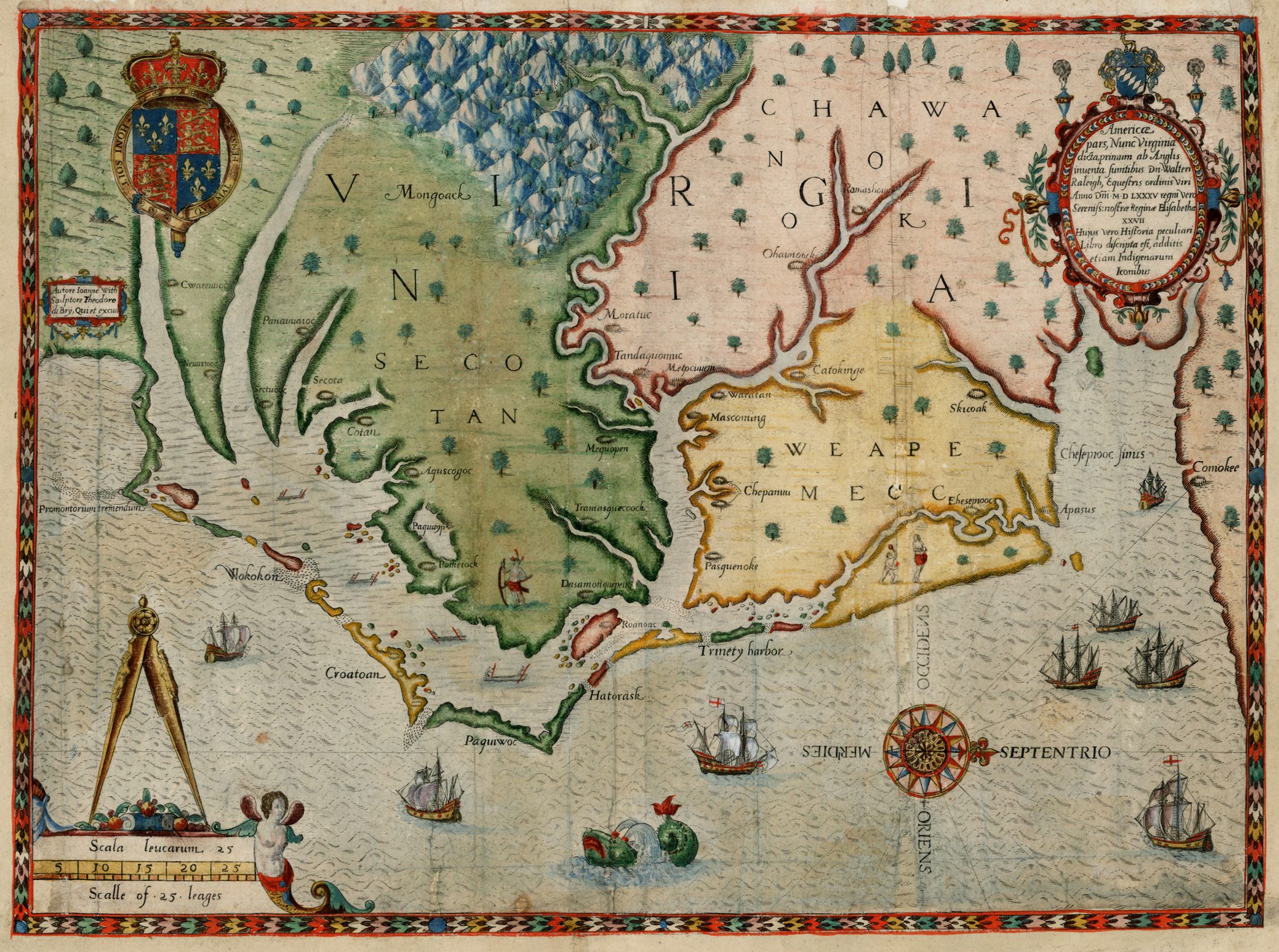
| 1 | [1590] WHITE, John Americæ / pars, Nunc Virginia / dicta, primum ab Anglis / inuenta sumtibus Dn. Walteri / Raleigh, Equestris ordinis Viri / Anno D[omi]ni M D LXXXV regni Vero / Sereniss: nostræ Reginæ Elisabethæ / XXVII / Hujus vero Historia peculiari / Libri discripta est, additis / etiam Indigenarum / Iconibus. [4b] Autore Ioanne With / Sculptore Theodore / de Brÿ, Qui et excud[it]. [1b] 302 x 418 PM: 305 x 421 From Hariot ‘Admiranda Narratio …’ Frankfurt-am-Main, 1590 | State 1: the village of ‘Chesepiooc’ (just above the decorative compass rose in the sea) is spelled ‘Ehesepiooc’ [4c]. cf. Cumming, Southeast, 12; Burden, North America, 76: state 1. |
| 2 | [1590-1590] WHITE, John Americæ / pars, Nunc Virginia / dicta, primum ab Anglis / inuenta sumtibus Dn. Walteri / Raleigh, Equestris ordinis Viri / Anno D[omi]ni M D LXXXV regni Vero / Sereniss: / nostræ Reginæ Elisabethæ / XXVII / Hujus vero Historia peculiari / Libri discripta est, additis / etiam Indigenarum / Iconibus. [4b] Autore Ioanne With / Sculptore Theodore / de Brÿ, Qui et excud[it]. [1b] 302 x 418 PM: 305 x 421 From Hariot ‘Admiranda Narratio …’ Frankfurt-am-Main, 1590 | 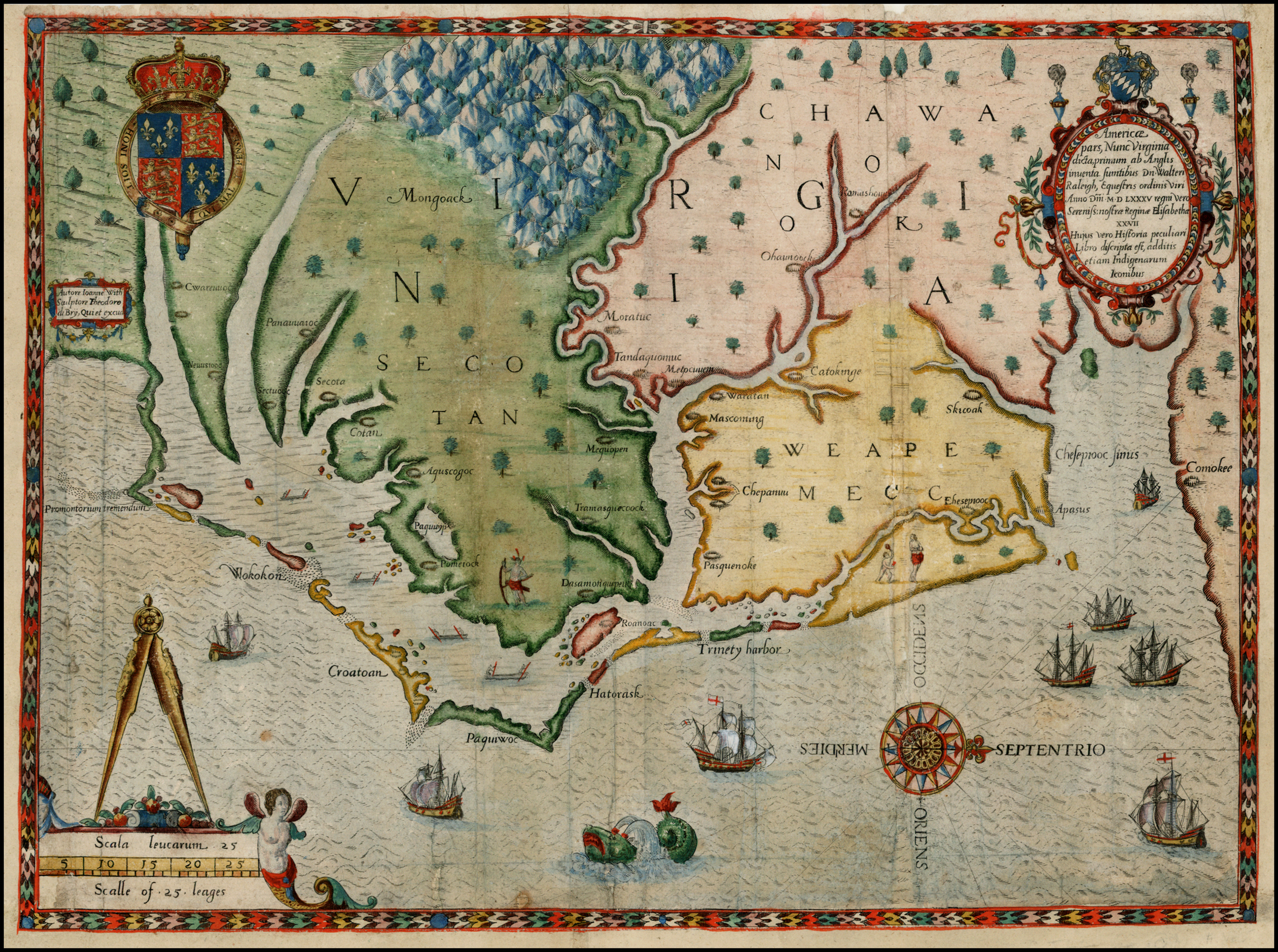 State 2: an attempt has been made to alter the original ‘E’ of ‘Ehesepiooc’ into a ‘C’, without erasure, the result being a combination letter [4c] Copies of this state were bound indiscriminately into different editions of the book. Cumming, Southeast, 12 (pl.14); Burden, North America, 76: state 2 (pl.76). |
| 3 | [1590-1590] WHITE, John Americæ / pars, Nunc Virginia / dicta, primum ab Anglis / inuenta sumtibus Dn. Walteri / Raleigh, Equestris ordinis Viri / Anno D[omi]ni M D LXXXV regni Vero / Sereniss: / nostræ Reginæ Elisabethæ / XXVII / Hujus vero Historia peculiari / Libri discripta est, additis / etiam Indigenarum / Iconibus. [4b] Autore Ioanne With / Sculptore Theodore / de Brÿ, Qui et excud[it]. [1b] 302 x 418 PM: 305 x 421 From Hariot ‘Admiranda Narratio …’ Frankfurt-am-Main, 1590 | State 3: the combination letter, created with the attempt to alter the original ‘E’ of ‘Ehesepiooc’ into a ‘C’, has been almost completely erased, and the letter ‘C’ substituted [4c] Copies of this state were bound indiscriminately into different editions of the book. TMC 9, p.4: G.I; Burden, North America, 76: plate 3. |
| 4 | [1590] WHITE, John [Untitled Map with letterpress heading: ‘The arriual of the Englishemen / in Virginia’] T[heodore de] B[ry]. [4e] 2 [4e] 115 x 224 From Hariot ‘Admiranda Narratio …’ Frankfurt-am-Main, 1590 | There were a number of issues, with the heading in different languages. Cumming, Southeast, 13; Burden, North America, 77 (pl.77). |
| 5 | [1606] HONDIUS, Jodocus Sr. VIRGINIAE / Item et / FLORIDAE / Americæ Provinciarum, nova / DESCRIPTIO. [2a] ‘Civitatum Floridæ imitatio.’ [1a] ‘Civitatum Virginiæ forma’ [3a] 342 x 483 PM: 345 x 485 From Mercator-Hondius ‘Atlas’ Amsterdam, 1606 | 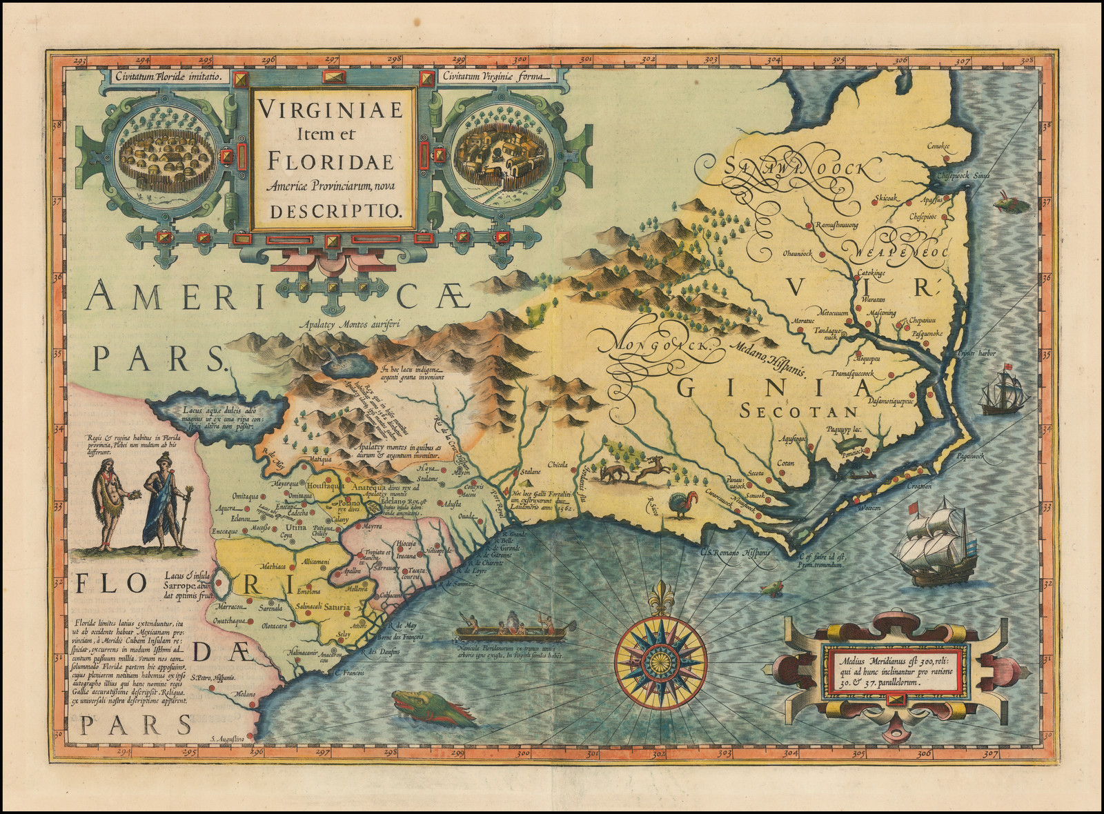 Cumming, Southeast, 26 (pl.20); Burden, North America, 151 (pl.151) |
| 6 | [1607] HONDIUS, Jodocus Sr. VIRGINIA / et / FLORIDA. [2a] 147 x 185 PM: 150 x 186 From Mercator-Hondius ‘Atlas Minor’ Amsterdam, 1607 | Cumming, Southeast, 27; Burden, North America, 155 (pl.155) |
| 7 | [1607-1625] HONDIUS, Jodocus Sr. VIRGINIA / et / FLORIDA. [2a] 147 x 185 PM: 150 x 186 From Samuel Purchas ‘Purchas His Pilgrimes’ London, 1624-1626 | another issue: set in English text, headed ‘HONDIVS his map of Florida’. Cumming, Southeast, 33; Burden, North America, 155. |
| 8 | [1607-1635] HONDIUS, Jodocus Sr. VIRGINIA / et / FLORIDA. [2a] 147 x 185 PM: 150 x 186 From ‘Historia Mundi: Or Mercator’s Atlas’ London, 1635 | another issue: set in English text, headed ‘VIRGINIA’ Cumming, Southeast, 37; Burden, North America, 155. |
| 9 | [1612] LESCARBOT, Marc Figure et description de la terre / reconue et habitée / par les Fr.a.nçois en la Floride / et audeça, gisante par les / 30 – 31 – et 32 – degrez. [5e] DE LA MAIN DE M. MARC. LESCARBOT. [3a] 160 x 225 From Lescarbot ‘Histoire De La Nouvelle France’ Paris, 1612 | There were subsequent editions in 1617 and 1618. Cumming, Southeast, 30 (pl.22); Burden, North America, 163 |
| 10 | [1624] SMITH, John [‘OULD / VIRGI / NI / A’] [1a – 2c] A description of part of the ad= / uentures of Cap: Smith in Virginia. [4a-5a] [One of ten images on one sheet] Grauen and extracted out of y.e generall history of Virginia, New England, and Som[m]er Iles, by Robert Vaughan. 130 x 155 From Smith ‘Generall Historie Of Virginia’ London, 1624 | State 1: This state can most easily be identified by the absence of engraved tree symbols on the plate. Cumming, Southeast, 32; Burden, North America, 212: state 1. |
| 11 | [1624-1624] SMITH, John [‘OULD / VIRGI / NI / A’] [1a – 2c] A description of part of the ad= / uentures of Cap: Smith in Virginia. [4a-5a] [One of ten images on one sheet] Grauen and extracted out of y.e generall history of Virginia, New England, and Som[m]er Iles, by Robert Vaughan. 130 x 155 From Smith ‘Generall Historie Of Virginia’ London, 1624 | State 2: with 25 additional place names, and 27 trees symbols. These include ‘Mountaynes forest’ [2a], ‘Waldens Oake’ [2b], ‘Masons bushe’ [2b], L:D: Lenox rocks [2b] ‘Bedfords valley’ [2c], ‘L. Salvage Rocke’ [4b], Beauchamps playne’ [4b], ‘Segars grove’, with tree symbols [4c], ‘Townfrows end’ [4c] and ‘Milmaids roade’ [4c] Cumming, Southeast, 32 (pl.32); Burden, North America, 212, state 2 (plate 212); |
| 12 | [1624-1624] SMITH, John [‘OULD / VIRGI / NI / A’] [1a – 2c] A description of part of the ad= / uentures of Cap: Smith in Virginia. [4a-5a] [One of ten images on one sheet] Grauen and extracted out of y.e generall history of Virginia, New England, and Som[m]er Iles, by Robert Vaughan. printed by James Reeve. 130 x 155 From Smith ‘Generall Historie Of Virginia’ London, 1624 | State 3: with 2 additional names ‘Danvers Ile’ [2c] and ‘P. Barkley’ [4c]; The imprint ‘printed by James Reeve’ has been engraved in the illustration of Smith with Powhatan and Pocohontas. Cumming, Southeast, 32; Burden, North America, 22, state 3. |
| 13 | [1624-1624] SMITH, John [‘OULD / VIRGI / NI / A’] [1a – 2c] A description of part of the ad= / uentures of Cap: Smith in Virginia. [4a-5a] [One of ten images on one sheet] Grauen and extracted out of y.e generall history of Virginia, New England, and Som[m]er Iles, by Robert Vaughan. printed by James Reeve. 130 x 155 From Smith ‘Generall Historie Of Virginia’ London, 1624 | 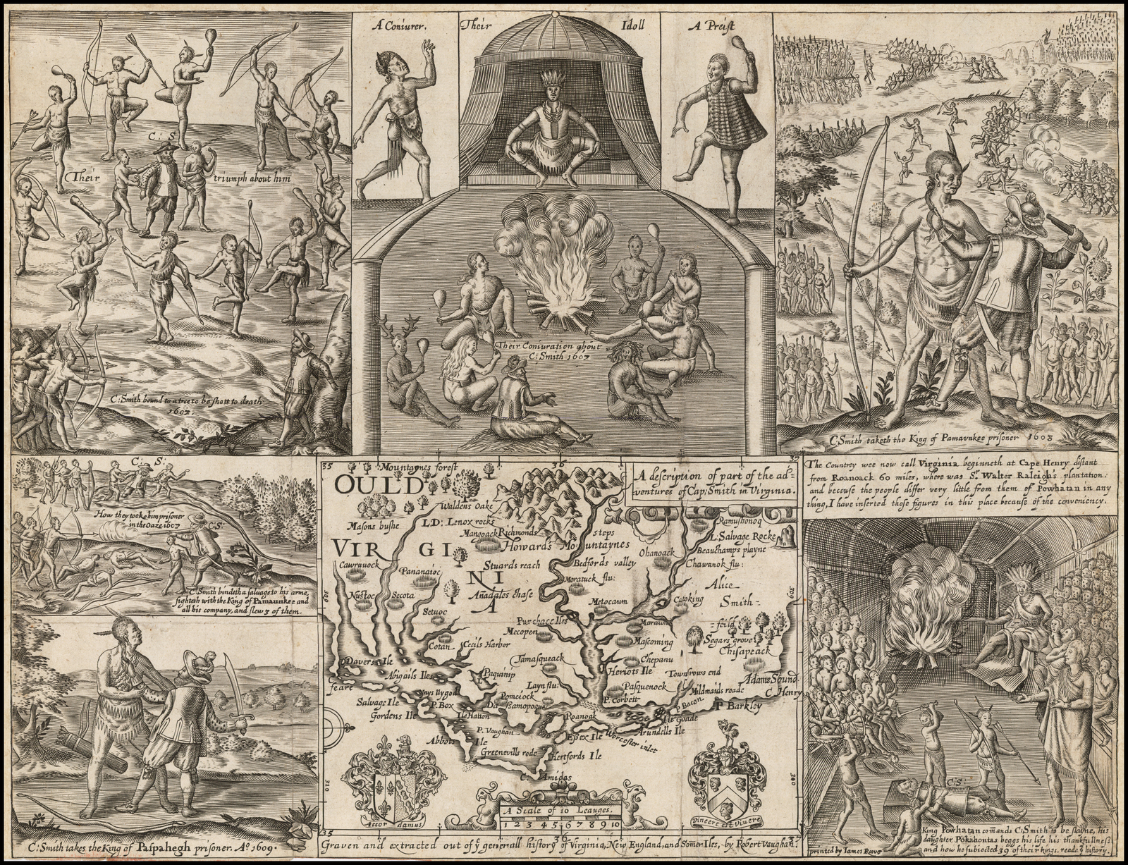 State 4: ‘Adams Sound’ has been inserted just above Cape Henry [5c]. Cumming, Southeast, 32; Burden, North America, 212, state 4. |
| 14 | [1630] CLOPPENBURGH, Johannes VIRGINIAE / Item et / FLORIDAE / Americæ Provinciarum, no= / va DESCRIPTIO. [1a] 186 x 354 PM: 187 x 355 From Cloppenburgh ‘Gerardi Mercatoris Atlas …’ Amsterdam, 1630 | Cumming, Southeast, 36; Burden, North America, 227 (pl.227). |
| 15 | [1630-1673] CLOPPENBURGH, Johannes VIRGINIAE / Item et / FLORIDAE / Americæ Provinciarum, no= / va DESCRIPTIO. [1a] 186 x 354 PM: 187 x 355 From Johannes Janssonius van Waesberge ‘Atlas …’ Amsterdam, 1673 | State 2: with the hachuring of the waves removed. There is no text on the reverse. In this state the map is also found in Henri du Sauzet’s ‘Atlas Portatif’ Amsterdam, 1734 [-1735] Not in Cumming, Southeast, but cf. 36; Burden, North America, 227: state 2. |
| 16 | [1630-1738] CLOPPENBURGH, Johannes VIRGINIAE / Item et / FLORIDAE / Americæ Provinciarum, no= / va DESCRIPTIO. [1a] 264 [5e, in border] 184 x 254 PM: 185 x 257 From Henri du Sauzet’s ‘Atlas Portatif’ Amsterdam, 1738 | State 3: with the plate number ‘264’ added in the upper right hand corner. Not in Cumming, Southeast, but cf. 36; Burden, North America, 227: state 3. |
| 17 | [1638] BLAEU, Willem Jansz. VIRGINIÆ / partis australis, / et FLORIDÆ partis / orientalis, interjacentiumq regionum / NOVA DESCRIPTIO. [2b] | State 1: the left hand ‘water-cherub’ lacks the ‘tail’ behind him. It should be noted that the longitude in the lower border runs ‘298 – 299 – 200’. Not in Cumming, Southeast, but cf. 41(pl.26); Burden, North America, 253: state 1; Moreland & Bannister, p.256 (ill). |
| 18 | [1638-1640] BLAEU, Willem Jansz. VIRGINIÆ / partis australis, / et FLORIDÆ partis / orientalis, interjacentiumq regionum / NOVA DESCRIPTIO. [2b] 384 x 499 PM: 387 x 501 From Blaeu ‘Theatrum Orbis Terrarum’ Amsterdam, 1640 | 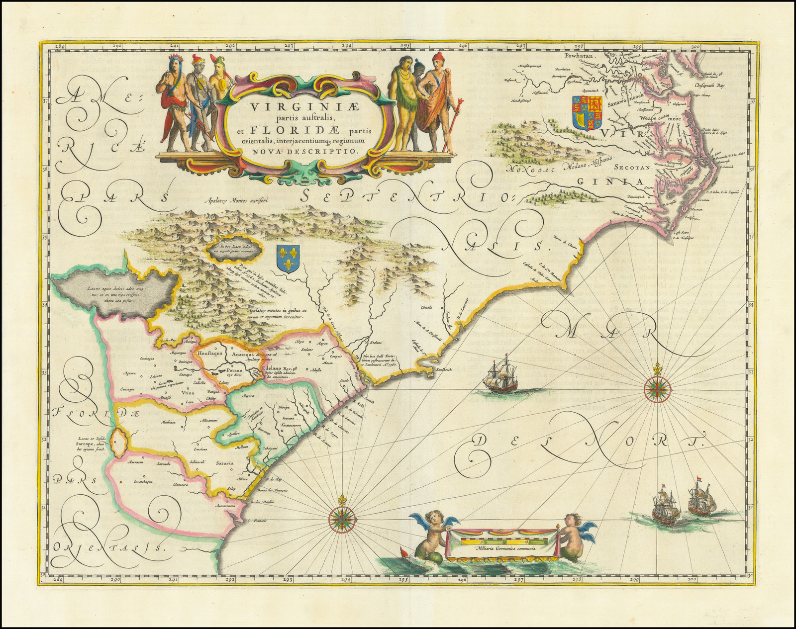 State 2: the left hand ‘water-cherub’ has had a ‘tail’ engraved in the wake behind him. Cumming, Southeast, 41(pl.26); Burden, North America, 253: state 2. |
| 19 | [1639] JANSSONIUS, Johannes VIRGINIÆ / partis australis, / et FLORIDÆ partis / orientalis, interjacentiumq regionum / NOVA DESCRIPTIO. [2b] 383 x 501 PM: 388 x 506 From Jansson ‘Le Theatre Du Monde’ Amsterdam, 1639 | State 1: without imprint. This plate is a very close copy of the Blaeu plate, even to the extent that the engraver copied the original mistake of engraving ‘200’ for ‘300’ in the lower border, but then noticed the error and added a lower tail to make the 2 into a 3. As there has always been some doubt as to the priority of the engraving, this establishes the Blaeu plates as the earlier. The principal means of differentiating between the two plates is that the Janssonius plate has the latitude grid in the right hand border shaded differently, so that the numerals are set beside shaded units, while the Blaeu has the numerals beside unshaded units. Cumming, Southeast, 42 (pl.26); Burden, North America, 254: state 1. |
| 20 | [1639-ca.1710] JANSSONIUS, Johannes VIRGINIÆ / partis australis, / et FLORIDÆ partis / orientalis, interjacentiumq regionum / NOVA DESCRIPTIO. [2b] AMSTELODAMI / Apud GERARDUM VALK et PETRUM SCHENK. [5e] 383 x 501 From Valk & Schenk Composite Atlases, Amsterdam, [ca. 1710] | State 2: with the imprint of Valk and Schenk inserted, and with the addition of a graticule of latitude and longitude. Cumming, Southeast, 42; Burden, North America, 254: state 2. |
| 21 | 1659 DUVAL, Pierre LA / VIRGINIE / Par P. Du Val / Geogra. du / Roy. / 1659. [5c] La VIRGINIE et les Isles BERMVDES. [1a – 4a, in border] [1a – 4a, in border] Inset: ‘Isles Bermudes’ [5a] 97 x 121 From Duval ‘Le Monde Terrestre’ Paris, [1661 ?] | State 1: dated 1659 in the title. Cumming, Southeast, 54 & p.282: 145B56; Burden, North America, 254: state 1. |
| 22 | 1659 [-1660] DUVAL, Pierre Carte / de / LA / VIRGINIE / Par P. Du Val / Geogra. du / Roy. / A PARIS. / 1659. [5c] La VIRGINIE et les Isles BERMVDES. [1a – 4a, in border] Inset: ‘Isles Bermudes’ [5a] 97 x 121 From Duval ‘Le Monde …’ Paris, 1660 | State 2: with additional words in the title, which is still dated 1659. Cumming, Southeast, 56 & p.282: 145B56; Burden, North America, 254: state 2. |
| 23 | 1659 [-1663] DUVAL, Pierre Carte / de / LA / VIRGINIE / Par P. Du Val / Geogra. du / Roy. / A PARIS. [5c] La VIRGINIE et les Isles BERMVDES. [1a – 4a, in border] Inset: ‘Isles Bermudes’ [5a] 97 x 121 From Duval ‘Le Monde …’ Paris, 1663 | State 3: with the date erased from the title. Cumming, Southeast, 56 & p.282: 145B56; Burden, North America, 254: state 3. |
| 24 | 1659 [-1672] DUVAL, Pierre Carte / de / LA / VIRGINIE / Par P. Du Val / Geographe / du Roy. / A PARIS. [5c] La VIRGINIE et les Isles BERMVDES. [1a – 4a, in border] Inset: ‘Isles Bermudes’ 97 x 121 From Duval ‘Le Monde …’ Paris, 1672 | 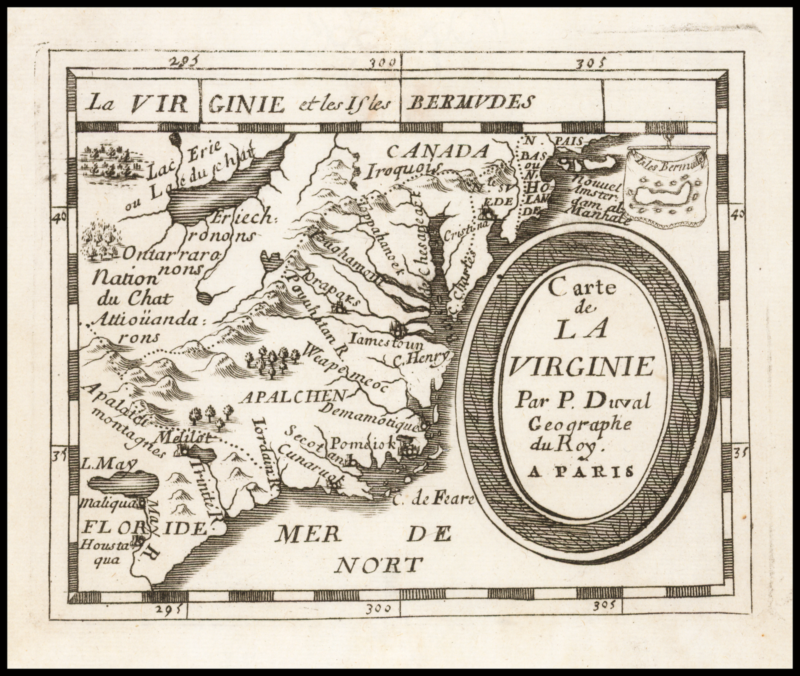 State 4: the title has been re-engraved; ‘N.Holande’ has been added to ‘N. BAS / PAS’ [4a] and & ‘al Manhate’ t ‘Nouuel Amster= / dam’ [4b] Cumming, Southeast, 56 & p.282: 145B56; Burden, North America, 254: state 4. |
| 25 | 1659 [-1687] DUVAL, Pierre Carte / de / LA / VIRGINIE / Par P. Du Val / Geographe / du Roy. / A PARIS. [5c] La VIRGINIE et les Isles BERMVDES. [1a – 4a, in border] Inset: ‘Isles Bermudes’ 97 x 121 From Duval ‘Le Monde …’ Paris, 1688 | State 5: the plate number ‘9’ has now been added. Cumming, Southeast, 56 & p.282: 145B56; Burden, North America, 254: state 5. |
| 26 | [1666] DUVAL, Pierre LA FLORIDE / FRANÇOISE Dressée sur / La Relation des / VOIAGES que Ribaut, / Laudonier, et Gourgues / y ont faits en 1562. / 1564. et 1567. / Par P. Du Val, / Geographe du Roy. [1e] 157 x 228 From Duval ‘Divers Cartes Et Tables’ Paris, [1666 ?] | 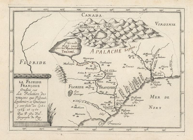 Cumming, Southeast, 61; Burden, North America, 381: state 1 (pl.381). |
| 27 | [1666 -1677] DUVAL, Pierre LA FLORIDE / FRANÇOISE Dressée sur / La Relation des / VOIAGES que Ribaut, / Laudonier, et Gourgues / y ont faits en 1562. / 1564. et 1567. / Par P. Du-Val, / Geographe du Roy. [1e] 157 x 228 From Duval ‘Divers Cartes Et Tables’ Paris, 1677 | State 2: the only observed difference is that a hyphen has been added to Duval’s name in the title. Cf. Cumming, Southeast, 61; Burden, North America, 381: state 2. |
| 28 | [1666] HILTON, William CAROLINA / Described. [1e] 151 x 224 From Anonymous ‘A Brief Description Of The Province Of Carolina’, London, 1666 | 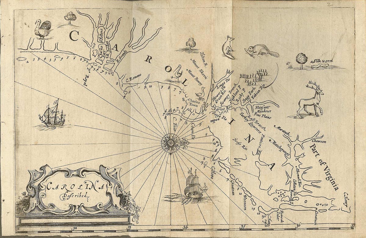 Cumming, Southeast, 60; Burden, North America, 392 (pl.392). |
| 29 | [1671] MONTANUS, Arnold VIRGINIÆ / partis australis, / et / FLORIDAE / partis orientalis, interia= / centiumq regionum / NOVA / DESCRIPTIO. [5e] 288 x 354 From Montanus ‘De Nieuwe En Onbekende Weereld’ Amsterdam, 1671 | 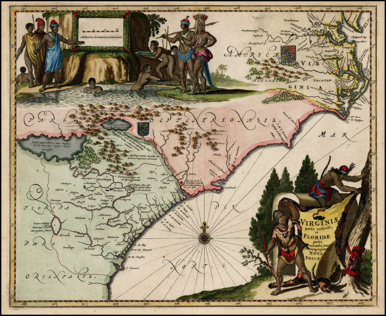 The map was re-issued, unchanged in John Ogilby’s ‘America …’, London, 1671, and Olfert Dapper’s ‘Die Unbekante Neue Welt’, Amsterdam, 1673. Cumming, Southeast, 67. |
| 30 | [1671-1729] MONTANUS, Arnold PARTIE MERIDIONALE / de la / VIRGINIE, / et la / PARTIE ORIENTALE / de la / FLORIDE, / dans / L’AMERIQUE SEPTENTRIONALE, / suivant les Memoires les plus exacts de ceux / qui les ont decouvertes, de nouveau mises en / lumiere par / PIERRE VANDER AA, / Marchand Libraire / A LEIDE. [5e] 288 x 352 From Aa ‘La Galerie Agreable’ Leiden, [1729] | State 2: the plate has been so heavily re-engraved as to be almost unrecognisable from the first state. Cumming, Southeast, 205 (pl.49) & cf. p.283. |
| 31 | [1671- ca.1735] MONTANUS, Arnold PARTIE MERIDIONALE / de la / VIRGINIE, / et la / PARTIE ORIENTALE / de la / FLORIDE, / dans / L’AMERIQUE SEPTENTRIONALE, / suivant les Memoires les plus exacts de ceux / qui les ont decouvertes, de nouveau mises en / lumiere par / PIERRE VANDER AA, / Marchand Libraire / A LEIDE. / A Amsterdam chez J. Covens et C. Mortier. [5e] 288 x 352 PM: 292 x 357 From Covens & Mortier ‘Atlas Nouveau’ Amsterdam, [ca. 1735] | State 3: with the addition of Covens and Mortier’s imprint in the title. Cumming, Southeast, 205. |
| 32 | [1672] BLOME, Richard A / Generall Mapp / of / CAROLINA. / Describeing its Sea / Coast and Rivers / London Printed for / Ric. Blome. [5b] 157 x 220 From Blome ‘A Description Of The Island Of Jamaica’, London, 1672 | 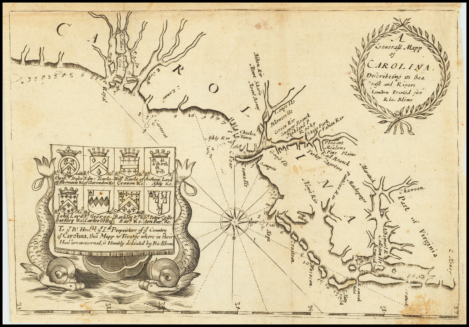 There is evidence of the erasure behind the latter half of the title, and of a name in the sea off Cape Fear, which may indicate a previous state. An example of the1678 edition seen seems to show that Cape Fear peninsula extended further into the sea, with ‘C. Fear’ being the erasure. Cumming, Southeast, 69 (pl.34). |
| 33 | [1672] LEDERER, John A MAP OF THE WHOLE TERRITORY TRAVERSED BY IOHN LEDERER IN HIS THREE MARCHES. [2a,ob – 4a, ob] Cross Sculpsit.[2e] 162 x 206 From Lederer ‘The Discoveries Of John Lederer’ London, 1672 | Cumming, Southeast, 68 (plate 36). |
| 34 | [1672] OGILBY, John A New / DISCRIPTION OF / CAROLINA / By Order of the / Lords Proprietors. [5a] James Moxon Scul. [4e] [Ashley & Cooper Rivers] [1c/1d – 2c/2d] [scale] ‘A Scale of English Miles’ – ‘5’ [2c] From Ogilby ‘America’ London, 1671 [-1672] | 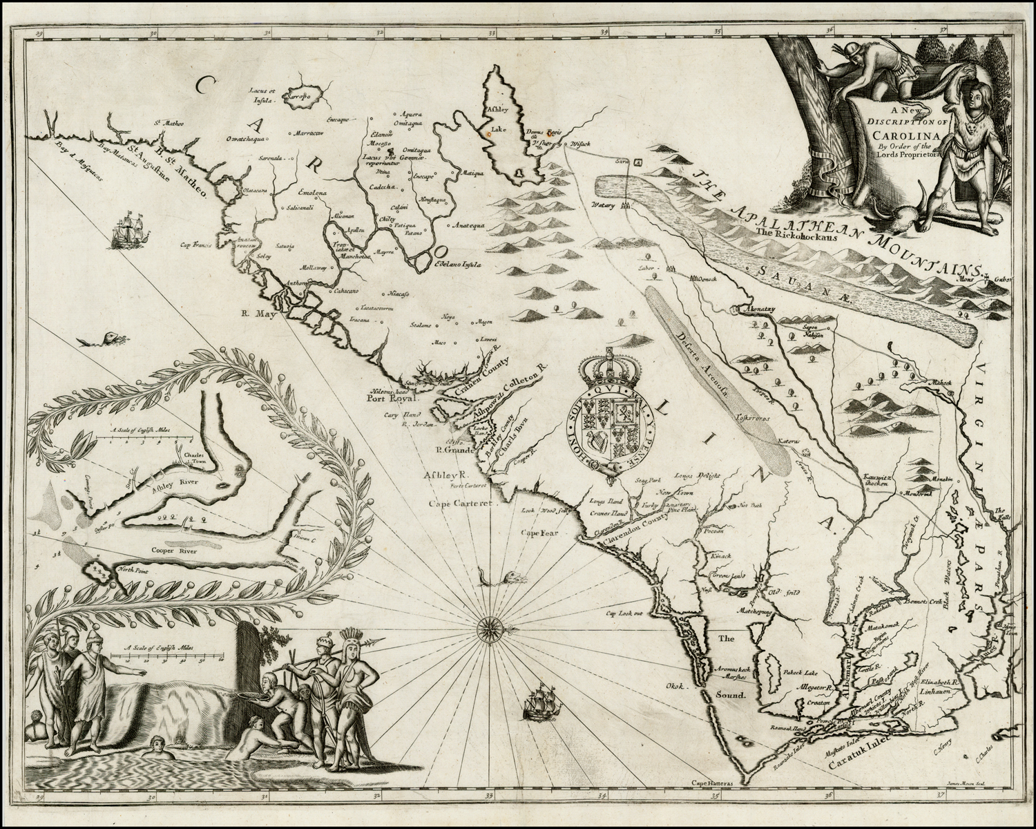 This map can also be found in Samuel Wilson’s ‘An Account Of The Province Of Carolina In America …’, G. Larkin for Francis Smith, London, 1682 |
| 35 | [1675] SPEED, John CAROLINA. [2d] 84 x 124 From Speed ‘Prospect Of The Most Famous Parts Of The World’ [Pocket edition] London, 1675 | 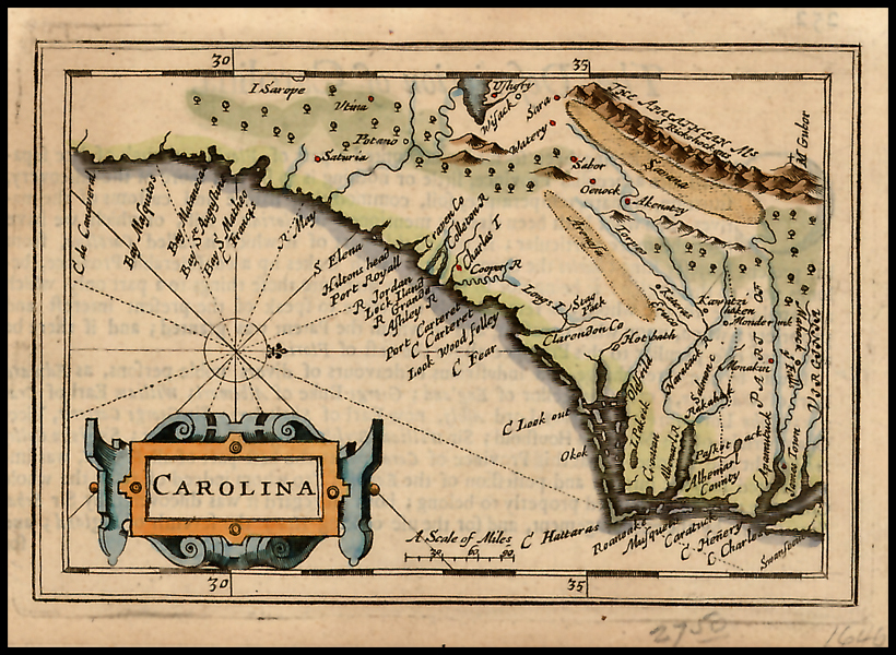 Cumming, 76. |
| 36 | 1676 SPEED, John A New / DESCRIPTION / OF / CAROLINA. / Sold by Tho: Bassett in Fleetstreet. / and Rich: Chiswell in S.t Pauls / Churchyard. [2d] F. Lamb Sculp. [4e] 375 x 510 PM: 381 x 515 From Speed ‘Prospect Of The Most Famous Parts Of The World’ [Folio edition] London, 1676 | 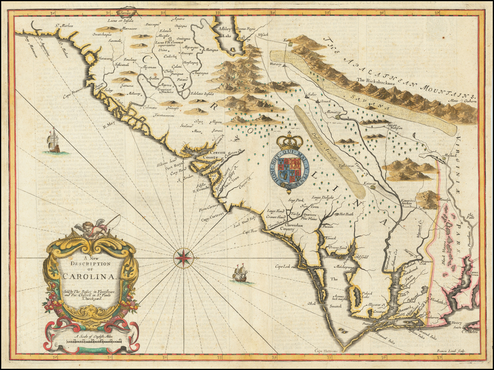 Cumming, Southeast, 77. |
| 37 | [1679] [DUVAL-] ANONYMOUS VIRGINIA. [5c] VIRGINIA et Insulæ BERMVDES. [2a-4a, in border] 75 [5a, in border] Inset: ‘Isles Bermudes’ [5a] 96 x 120 From [Duval] ‘Geographiae Universalis’ Nuremberg, 1679 | Cumming, Southeast, 85. |
| 38 | [1680] MORDEN, Robert CAROLINA / VIRGINIA / MARY LAND / & / New Iarsey / by / Rob.t Morden. [4d] B: 120 x 104 PM: 130 x 114 From Morden ‘Geography Rectified’ London, 1680 | Cumming, Southeast, 88. |
| 39 | [1680-1687] MORDEN, Robert A / New Map / of / CAROLINA / By / Rob.t Morden. [4d] (ib): 118 x 102 PM: 130 x 113 From Blome ‘The Present State Of His Majesties Isles … In America’ London, 1687 | 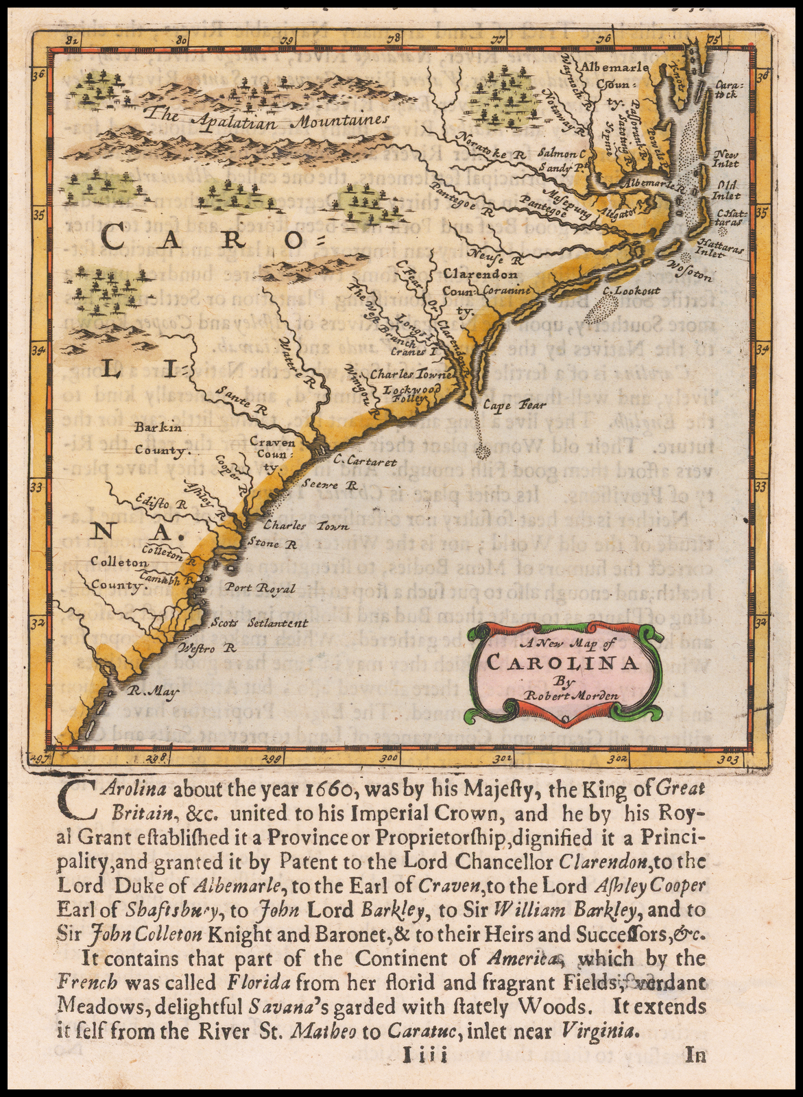 State 2: the title has been re-engraved. A numnber of changes have been to the coastal names between Charleston and Cape Fear. Below ‘Ashly Riuer’ are now marked ‘Stono R.’ & ‘Edisto R.’ (replacing ‘R. Grande’ and ‘Lock Iland’); from Cape Fear southwards the following new names appear: ‘Charles / Town’ ‘Watere R.’ and ‘Sante R.’ (with the original river symbols extended) [3d] ‘Edelano / I.’ and ‘S.t Catalina’ (with river symbol) are marked between ‘S. Elena’ and ‘R. May’, with the river from ‘S. Elena’ extended to make a river [3d]. Cumming, Southeast 107: not identified as the same plate as his 88. |
| 40 | [1682] GASCOYNE, Joel To The / Right Honorable / Will. Earle of Craven, / Pallatine and the rest of y.e / true and absolute Lords and / Proprietors, of the Province of / CAROLINA. / This Map is humbly Dedicated / By Ioel Gascoyne. / [rule] / A New Map / of the Country of / CAROLINA. / With it’.s Rivers, Harbors, Planta= / tions, and other accomodations. / don from the latest Surveighs / and best Informations. by order / of the Lords Proprietors. / [rule] / Sold by Ioel Gascoyne at the Signe of / the Plat nere Wapping old Stayres. / And by Robert Greene at the Rose and / Crowne in y.e middle of Budge Row. / [imprint of a third mapseller, in 2 lines] / LONDON. [2c] Inset: ‘A Perticular Map / for the going into / Ashly and Cooper / River.’ [2d; 1d/1e – 2d/2e] [scale] ‘A Scale of Miles’ – ‘3’ (28mm) [2e] [key] 1-5. [1e] 494 x 600 Inset: (ib): 120 x 216 From Gascoyne Separate publication [1682] | The map was also issued in ‘A True Description Of Carolina … Printed for Joel Gascoin And Robert Greene …’, Joel GASCOYNE & Robert GREENE, London, [1682] Although there is no known example, state 2 shows signs of the erased imprint of a third mapseller in the title. Black, Blathwayt Atlas, 23: noting the three possible states; cf. Cumming, Southeast, 92 & p.159: the original announcement. |
| 41 | [1682 – ca.1682] GASCOYNE, Joel To The / Right Honorable / Will. Earle of Craven, / Pallatine and the rest of y.e / true and absolute Lords and / Proprietors, of the Province of / CAROLINA. / This Map is humbly Dedicated / By Ioel Gascoyne. / [rule] / A New Map / of the Country of / CAROLINA. / With it’.s Rivers, Harbors, Planta= / tions, and other accomodations. / don from the latest Surveighs / and best Informations. by order / of the Lords Proprietors. / [rule] / Sold by Ioel Gascoyne at the Signe of / the Plat nere Wapping old Stayres. / And by Robert Greene at the Rose and / Crowne in y.e middle of Budge Row. / [erasure of the imprint of a third mapseller ?, in 2 lines] / LONDON. [2c] Inset: ‘A Perticular Map / for the going into / Ashly and Cooper / River.’ [2d; 1d/1e – 2d/2e] [scale] ‘A Scale of Miles’ – ‘3’ (28mm) [2e] [key] 1-5. [1e] 494 x 600 Inset: (ib): 120 x 216 From Gascoyne Separate publication [1682] | State 2: with evidence of the erasure of the imprint of a third mapseller from the title. Cumming, Southeast 92; Black, Blathwayt Atlas, 23: describing the three possible states. |
| 42 | [1682 – ca.1682] GASCOYNE, Joel To The / Right Honorable / Will. Earle of Craven, / Pallatine and the rest of y.e / true and absolute Lords and / Proprietors, of the Province of / CAROLINA. / This Map is humbly Dedicated / By Ioel Gascoyne. / [rule] / A New Map / of the Country of / CAROLINA. / With it’.s Rivers, Harbors, Planta= / tions, and other accomodations. / don from the latest Surveighs / and best Informations. by order / of the Lords Proprietors. / [rule] / Sold by Ioel Gascoyne at the Signe of / the Plat nere Wapping old Stayres. / And by Robert Greene at the Rose and / Crowne in y.e middle of Budge Row. / [erasure of the imprint of a third mapseller ?, in 2 lines] / LONDON. [2c] Inset: ‘A Perticular Map / for the going into / Ashly and Cooper / River.’ [2d; 1d/1e – 2d/2e] [scale] ‘A Scale of Miles’ – ‘3’ (28mm) [2e] [key] 1-5. [1e] From Gascoyne Separate publication [1682] | State 3: the map has been substantially revised and updated in several areas, with extensive geographical changes. The lower course of the River May has been moved further south, with its mouth now on the heavy rhumb line coming north-west out of the southern compass rose [2b]. In the second state the lake near ‘Westoh’ [3b], placed to the south of the lettering ‘Pleasant Valley and / Lake’, was long and narrow, and orientated southwest to northeast. In the third state the original lake has been erased and replaced by two branches of a river; ‘Westoh’ has been erased and moved to the north (although the original symbol is still partially visible), and a new lake engraved, which is now bulbous and orientated north-south [3b]. At the head of the Ashley River in the second state was the note ‘Earle Shaftsbury / Signory call’d / Wadwad malow’ [3c], in this state the words ‘Wadwad malow’ have been erased. ‘Fairlons’ has been re-engraved as ‘Fairlauns’ [3c] The sizes of the various plantations at the head of the Cooper River have been erased. In the inset, the peninsula between the Ashley and Copper Rivers was originally 65mm wide at the upper margin, in this state is is 27mm wide. This reduction has been effected by erasing the north shore of the peninsula, and moving it south, as also with the north bank of the Cooper River. ‘The Apalatian Mountaines’ have been entirely re-engraved closer to the settlements, and trees and hills inserted in the top right corner [5a]. The upper courses of the Edisto, Cooper and Santee Rivers have been revised, and number of names moved. Cumming, Southeast 92 (pl.36: Yale eg.); Black, Blathwayt Atlas, 23: noting the three possible states; Johnson, America Explored, p.108 (ill: Yale eg. ?). |
| 43 | [1682 A] SELLER, John Sr. CAROLINA / Newly Discribed / By Iohn Seller. [5a] 112 x 140 From Seller ‘Atlas Maritimus’ [Pocket Edition] London, 1682 | Plate 1: This plate does not mark St. Augustine; Cumming, Southeast, 93. |
| 44 | [1682 B] SELLER, John Sr. CAROLINA / Newly Discribed / By Iohn Seller. [4a] 115 x 142 From Wilson ‘An Account Of The Province Of The Carolinas’ London, 1682 | Plate 2: ‘S.t Augustine’ is shown [1b]. cf. Cumming, Southeast, 93. |
| 45 | [1685] THORNTON, John, MORDEN, Robert & LEA, Philip A / New Map of / CAROLINA / By / Iohn Thornton at the Platt in the Minories, / Robert Morden at y.e Atlas in Corn-hill, / And by Phillip Lea at the Atlas & Herculus / in the Poultry. / LONDON. [3d] Inset: ‘A Perticuler Map / for the going into / Ashley and Cooper / Rivers.’ [5e] 542 x 452 Inset: (ib) 98 x 133 / From Thornton et al. Separate publication [ca. 1685] | 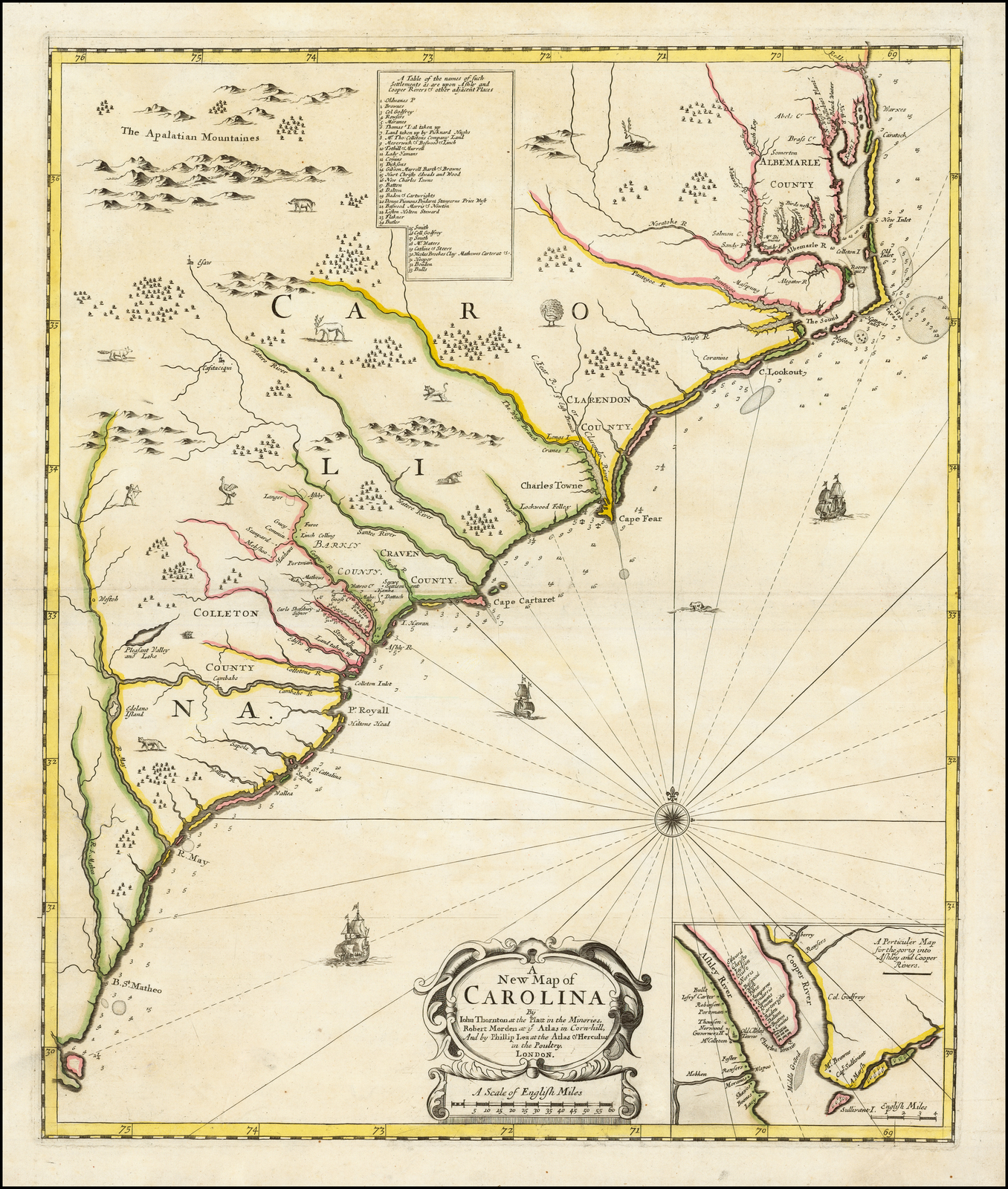 Cumming, Southeast 104. |
| 46 | [1685 – ca.1690] THORNTON, John, MORDEN, Robert & LEA, Philip A / New Map of / CAROLINA. / [rule] / By / Philip Lea at the Atlas and Hercules / in Cheap side / LONDON. [3d] Inset: ‘ASHLEY & COOPER RIVER’ [5e] 542 x 452 Inset: (ib) 98 x 133 From Lea Separate publication [ca. 1690] | State 2: with the imprint of Philip Lea substituted. The second title has been added above the inset, which has been enlarged, but without additional information; the left border now touches the title cartouche. Cumming, Southeast, 104A. |
| 47 | [1685 – ca.1732] THORNTON, John, MORDEN, Robert & LEA, Philip A / New Map of / CAROLINA. / [rule] / Sold by Geo: Willdey at the Great Toy, / Spectacle, China-ware, and Print Shop, / y.e Corner of Ludgate Street near S.t Pauls / LONDON. [3d] Inset: ‘ASHLEY & COOPER RIVER’ [5e] 542 x 452 Inset: (ib) 111 x 146 From Willdey Separate publication [ca. 1732] | State 3: with the imprint of George Willdey substituted. Cumming, Southeast, 104B; MCS 39, no.10c. |
| 48 | [1688] [MORDEN, Robert /] ANONYMOUS ‘Nouvelle Carte de la CAROLINE par R. Morden.’ ‘P.195’ 125 x 111 From [Blome] ‘L’Amerique Angloise’ Amsterdam, 1688 | 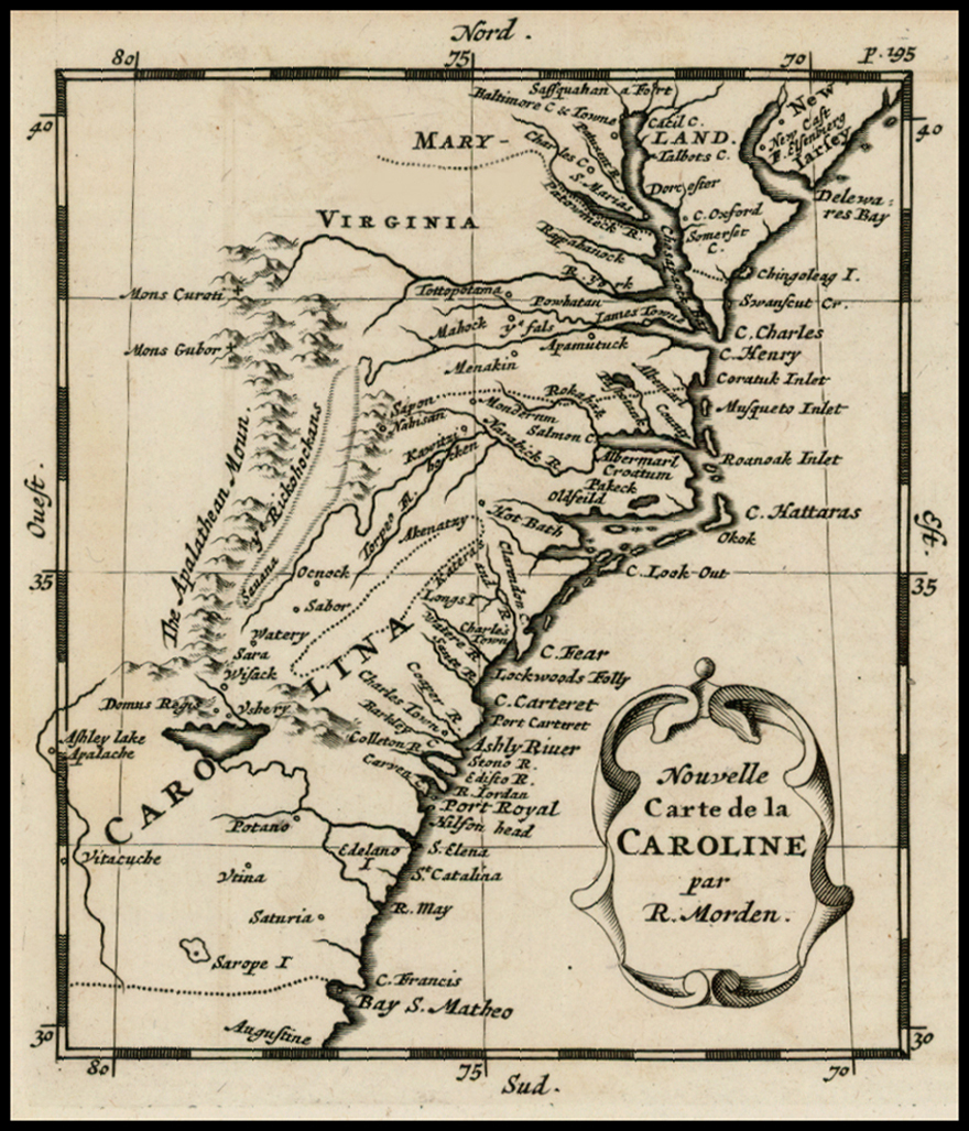 Cumming, Southeast, 90. |
| 49 | [1688] MORDEN, Robert A New Map of / CAROLINA / By / Robert Morden. [4d] 124 x 125 From Morden ‘Geography Rectified’ London, 1688 | Cumming, Southeast 110. |
| 50 | [1688-1693] MORDEN, Robert A New Map of / CAROLINA / By / Robert Morden. [4d] Page 74 [1a] 124 x 125 From Morden ‘Geography Rectified’ London, 1693 | State 2: with the page number inserted. Cumming, Southeast 110. |
| 51 | [1692] MULLER, Johann Ulrich [Untitled Map Of The Carolinas] V [3a, ob]; letterpress heading outside the lower border] ‘Virginia’ Inset: ‘I. Bermudes’ [5e] 63 x 77 From Muller ‘Kurtz-Bundige Abbild-Und Vorstellung Der Gantzen Welt’ Ulm, 1692 | Cumming, Southeast, 111. |
| 52 | [1692-1702] MULLER, Johann Ulrich [Untitled Map Of The Carolinas] V c [3a, ob] [Letterpress text below] ‘Dieses Cartlein halt in sich: / I. Virginien. / Die Stadte darinnen seyn: / 1. Pomejok. /…’ Inset: ‘I. Bermudes’ [5e] 63 x 77 From Muller ‘Neu-Aussgefertigter Kleiner Atlas’ Ulm, 1702 | Cumming, Southeast, 135. |
| 53 | [1695 ca.] THORNTON, John & MORDEN, Robert [Untitled Map Of South Carolina] To the Right Honorable / William Earl of Craven, / PALATINE. Iohn Earl of Bath. George Lord Cartaret. / Anthony Lord Ashley. S.r Iohn Colleton Barr:t / Thomas Archdale. Thomas Amy. and the Hieres of / Seth Sothel. Esq.rs / This New Map of the Cheif Rivers, Bayes, Creeks, / Harbours, and Settlements, in / SOUTH CAROLINA. / Actually Surveyed is humbly Dedicated / by / Iohn Thornton & Rob.t Morden. [1a] Sold by { Iohn Thornton in the Minories and / { Robert Morden in Cornhill London. [5d] 480 x 570 From Thornton & Morden Separate publication, London, [ca.1695] | Cumming, Southeast, 118. |
| 54 | [1700] MORTIER, Pierre CARTE GENERAL / DE LA / CAROLINE. / Dresse sur les Memoires le plus Nouveaux / PAR LE SIEUA S*** / A AMSTERDAM. / [rule] / Chez PIERRE MORTIER, Libraire. / Avec Privilege de Nos Seigneurs les Etats. [3a] [‘ASHLEY RIV.’ & ‘COOPER RIV.’] [5e] 110 x 114 566 x 465 From Mortier ‘Suite Du Neptune Francois’ Amsterdam, [1700] | Cumming, Southeast, 120. |
| 55 | [1700 – ca.1730] MORTIER, Pierre CARTE GENERAL / DE LA / CAROLINE. / Dresse sur les Memoires le plus Nouveaux / PAR LE SIEUA S*** / A AMSTERDAM. / [rule] / Chez IEAN CÔVENS & CORNEILLE MORTIER. / Avec Privilege de Nos Seigneurs les Etats. [3a] 84 [5e, in border] 571 x 465 Mortier ‘Suite Du Neptune Francois’ Amsterdam, [ca.1730] | State 2: with the subsitution of the Covens and Mortier imprint, and the plate number inserted. Not in Cumming, Southeast, but cf.120. |
| 56 | [1700] MORTIER, Pierre CARTE / PARTICULIERE / DE LA / CAROLINE / Dresse sur les Memoires / le plus Nouveaux. / PAR LE SIEUR S*** / A AMSTERDAM. / [rule] / Chez PIERRE MORTIER, Libraire. / Avec Privilege de Nos Seigneurs les Etats. [1a] 480 x 602 From Mortier ‘Suite Du Neptune Francois’ Amsterdam, [1700] | Cumming, Southeast, 121. |
| 57 | [1700 – ca.1730] MORTIER, Pierre CARTE / PARTICULIERE / DE LA / CAROLINE / Dresse sur les Memoires / le plus Nouveaux. / PAR LE SIEUR S*** / A AMSTERDAM. / [rule] / Chez PIERRE MORTIER, Libraire. / Avec Privilege de Nos Seigneurs les Etats. [1a] 85 [5e] 474 x 594 From Mortier ‘Suite Du Neptune Francois’ Amsterdam, [ca.1730] | State 2: with the engraved plate number ’85’ added in the lower right hand corner of the map. Not in Cumming, Southeast, but cf.121. |
| 58 | [1707] AA, Pieter van der ZEE en LAND- / Togten der / FRANSZEN / Gedaan na, en in’t / AMERICAANS / Gewest van / FLORIDA, / aller-eerst door / IOH. PONTIUS / Ontdeckt. [5d] Uytgevoerd te LEYDEN door PIETER VANDER AA met Privilegie. [1e, ob – 5e, ob] Pontius [5e, ob] Pag: 11 [5a, ob] 150 x 228 From Aa ‘Naaukeurige Versameling Der Gedenk-Waardigste Zee En Land-Reysen’ Leiden, 1707 | Cumming, Southeast, 143. |
| 59 | [1707-1707] AA, Pieter van der ZEE en LAND- / Togten der / FRANSZEN / Gedaan na, en in’t / AMERICAANS / Gewest van / FLORIDA, / aller-eerst door / IOH. PONTIUS / Ontdeckt. [5d] Uytgevoerd te LEYDEN door PIETER VANDER AA met Privilegie. [1e, ob – 5e, ob] Pontius [5e, ob] 150 x 228 From Aa ‘Cartes Des Itineraires & Voiages Modernes’ Leiden, [1707] | State 2: set within an elaborate frame border, which is printed from a separate plate. With the page number erased. Cumming, Southeast, 143. |
| 60 | [1707-1714] AA, Pieter van der ZEE en LAND- / Togten der / FRANSZEN / Gedaan na, en in’t / AMERICAANS / Gewest van / FLORIDA, / aller-eerst door / IOH. PONTIUS / Ontdeckt. [5d] Voyages par Mer et par Terre des Francois dans la Floride, premierement decouverte par Jean Pontius, dressez sur ses Memoires, et perfectionnez par un grand nombre d’autres plus recens, de nouveau mis au jour par Pierre vander Aa, a Leide. Avec Privilege. [1e, ob – 5e, ob] 150 x 228 From Aa ‘Atlas Nouveau’ Leiden, [1714] | State 3: a second title, in French, has been engraved outside the lower border. Cumming, Southeast, 143. |
| 61 | [1708] MOLL, Herman CAROLINA / By Herman Moll Geographer. / Note that y.e plantations are marked thus [symbol]. [3d; 1a/e – 3a/e] Vol.1. Pag. 325 [1a, ob] 176 x 155 From John Oldmixon ‘British Empire 1708’ [on sheet with a map of Bermuda] | Cumming, Southeast, 148. |
| 62 | [1708-1741] MOLL, Herman CAROLINA / By Herman Moll Geographer. / Note that y.e plantations are marked thus [symbol]. [3d; 1a/e – 3a/e] 176 x 155 From John Oldmixon ‘British Empire’ 1741 | State 2: with the page number erased from outside the upper border. Cumming, Southeast, 148. |
| 63 | [1708 – ca.1750 ] MOLL, Herman CAROLINA / By Herman Moll Geographer. / Note that y.e plantations are marked thus [symbol]. [3d; 1a/e – 3a/e] 53 [5a] 176 x 155 From [?] | State 3: with the plate number ’53’ engraved in the top right hand corner of the Bermudas map. |
| 64 | [1708-1781] MOLL, Herman CAROLINA / By Herman Moll Geographer. / Note that y.e plantations are marked thus [symbol]. [3d; 1a/e – 3a/e] 53 [5a] Printed for Carington Bowles in London. [3e, in Carolinas map] 176 x 155 From Moll ‘Atlas Minor’ London, [1781] | State 4: with Carington Bowles imprint inserted under the title cartouche of the Carolinas map. Cumming, Southeast, 148. |
| 65 | [1709] KOCHERTHAL, Josua van [Untitled Map Of ‘Nord CAROLINA’ ‘Sud CAROLINA’ ‘VIRGINIA’] 158 x 188 From Kocherthal ‘Aussfuhrlich Und Umstandlicher Bericht Von Der Beruhmten Landschaffte Carolina’ Frankfurt, 1709 | Cumming, Southeast, 149. |
| 66 | 1709 LAWSON, John [Untitled Map Of The Carolinas] To His Excellency / WILLIAM LORD CRAVEN Palatine; / The Most Noble HENRY DUKE OF BEAUFORT; / The Right Hono.ble IOHN LORD CARTERET; / The Hono.ble MAURICE ASHLEY ESQ:; / SR. IOHN COLLETON BARONET; / IOHN DANSON ESQ:; / And the rest of the True and Absolute LORDS / PROPRIETORS / of / CAROLINA in AMERICA / This Map is Humbly Dedicated / By Io.n Lawson / Surveyor General of North Carolina. / 1709. [4d] Iohn Senex sculpsit. [4e] ‘MAGNUM SIGILLUM CAROLINÆ DOMINORUM.’ [the Great Seal of the Carolinas] 379 x 308 From Lawson ‘A New Voyage To Carolina’, London, 1709 | The book first appeared as part of Captain John Stevens’ ‘A New Collection Of Voyages And Travels’, vol.1, 1710. Cumming, Southeast, 150. |
| 67 | [1711] CRISP, Edward A Compleat Description Of The Province of CAROLINA In 3 Parts. 1.st The Improved parts from the Surveys Of Maurice Mathews & M.r John Love. 2.ly The West part By Cap.t Tho. Nairn 3.ly A Chart Of The Coast from Virginia To Cape Florida. Published By Edw. Crisp. [1a, ob – 5a, ob] To His Excellency / WILLIAM LORD CRAVEN Palatine / The Most Noble HENRY Duke of BEAUFORT / The R.t Hon.ble IOHN Lord CARTERET / The Hon.ble MAURICE ASHLEY Esq. / S.r IOHN COLLETON Baronet / IOHN DANSON Esq.r / And the rest of the / TRUE and ABSOLUTE L.DS / PROPRIETORS of the PROVINCE / OF / CAROLINA / This MAPP is Humbly Dedicated / By EDW. CRISP. [3b] Engraven by Iohn Harris in Bull-head Court / Newgate Street London. [3c] Sold at the Carolina Coffee House in Birchen Lane London. [3c] Insets: A MAP / OF / SOUTH CAROLINA / Shewing the Settlements / of the / ENGLISH FRENCH & INDIAN / NATIONS / from Charles Town to the River / Mississipi / by Cap.t Tho. Nairn. [scale] ‘A Scale of English Miles’ – ‘240’ [1a; 1a/b – 2a/b] ]’THE TOWN AND HARBOUR OF S.T AUGUSTIN.’ [2a] ‘A Plan of the TOWN & HARBOUR of / CHARLES=TOWN. [scale] ‘A Scale of 80 Perches or 2 Furlongs’ – ’80’ – [0] – [10] [4c; 4c/4d] A New CHART of the Coast of CAROLINA and FLORIDA from Cape Henry to the Havana in the Island of CUBA Described by Cap. Tho. Nairn and others. [5e] 760 x 990 From Crisp Separate publication, London, [1711] | Cumming, Southeast, 151 (pl.44: central sheet, & pl.45: 1st inset). |
| 68 | [1711] OCHS, Johann Rudolf ‘Die Provinz Nord und Sud Carolina.’ ‘Ioh. Hen. Sculp.’ 215 x 265 From Ochs ‘Americanischer Wegweiser’ Bern, 1711 | Cumming, Southeast, 152. |
| 69 | [1712] VISCHER, M. [Untitled Map Of North And South Carolina] Die vornehmste / Eigenthums Herren und Besitzer / von / CAROLINA. / Lord CRAVEN. / Hertzog von BEAVFORT. / Lord CARTERET. / ASHLEY, Esq. / COLLETON, Baronet. / DANSON, Esq. / etc. etc. [5e] ‘MAGNUM SIGILLUM CAROLINÆ DOMINORUM’ [5d] 378 x 302 PM:: 384 x 310 From [John Lawson] ‘Allerneuste Beschreibung Der Provintz Carolina’ Hamburg, 1712 | Cumming, Southeast, 152. |
| 70 | [1714] HOMANN, Johann Baptist VIRGINIA / MARYLANDIA / et / CAROLINA / IN AMERICA SEPTENTRIONALI / Britannorum industria excultæ / repræsentatæ / â / Ioh. Bapt. Homann S.C.M. Geog. / Norimbergæ. [5d] | Cumming, Southeast, 156 (pl.46). |
| 71 | [1714 – ca.1724 ] HOMANN, Johann Baptist VIRGINIA / MARYLANDIA / et / CAROLINA / IN AMERICA SEPTENTRIONALI / Britannorum industria excultæ / repræsentatæ / â / Ioh. Bapt. Homann S.C.M. Geog. / Norimbergæ. / Cum Privilegio Sac. Caes. Majest. [5d] 490 x 587 From Homannn ‘Atlas Novus’ Nuremberg, [1724-] | State 2: with the privilege added in the title. Cumming, Southeast, 156. |
| 72 | [1719] CHATELAIN, Henri Abraham NOUVELLE / CARTE DE LA / CAROLINE. [5e] ON SHEET: ‘CARTE QUI CONTIENT UNE DESCRIPTION DES ILES & TERRES QUE LES ANGLOIS POSSEDENT DANS L’AMERIQUE SEPTENTRIONALE, ET EN PARTICULIER DE LA JAMAIQUE / DES ILES BARBADES, DE LA NOUVELLE ANGLETERRE, DES BARMUDES, de la CAROLINE, de la PENSILVANIE, Et du NEW-FOUNDLAND, AVEC UN ETAT DE CHAQUE PAIS, DU TEMS DE SA DECOUVERTE, DE SES DIFFERENTES PRODUCTIONS, et de la NATURE du COMMERCE QUI SIY FAIT. [1a, ob – 5a, ob] Tome VI N.o 26 Pag: 100. [5a, ob] 55 x 73 with text: 143 x 73 Border: 392 x 522 From Chatelain ‘Atlas Historique’ Vol.VI Amsterdam, 1719 | Cumming, Southeast, 173 |
| 73 | [1721] [MOLL /] KEIZER, Jacob CAROLINA / door / Herman Mol. / de Plantasien zyn aldus gemerkt (symbol). [5e] J. Keyzer F. [5e] I. Deel Blatz 249 5a, ob] [on sheet with] DE BERMUDAS / EYLANDEN / Verdeelete in deszelfs Wyken / door H. Mol. [3a] 168 x 151 Sheet: 168 x 252 From [Oldmixon] ‘Het Britannische Ryk In America’ Amstedam, 1721 | Cumming, Southeast, 183. |
| 74 | 1729 MOLL, Herman CAROLINA / By / H. Moll Geographer. 1729. [5d] 202 x 275 From Moll ‘Atlas Minor’ London, 1729 | State 1: dated 1729 in the title; ‘AZILIA’ is named north of ‘SOUTH / CAROLINA’ [2c]; Cumming, Southeast, 206A. |
| 75 | 1729 [- ca.1732] MOLL, Herman CAROLINA / By / H. Moll Geographer. [5d] 51 [5a] 199 x 275 From Moll ‘Atlas Minor’ London, [ca. 1732] | State 2: with the date erased, and the plate number ’51’ added [5a]. Cumming, Southeast, 206B. |
| 76 | 1729 [- ca. 1736] MOLL, Herman CAROLINA / By / H. Moll Geographer. [5d] 51 [5a] 202 x 276 From Moll ‘Atlas Minor’ London, [ca. 1736] | State 3: ‘according to the last Charter’ has been added to ‘The South Bounds of Carolina’, along the lower border [2d-4d]; ‘GEOR / GIA’ is named inland from Port Royal [3d]; Cumming, Southeast, 206C. |
| 77 | 1729 [-1739] MOLL, Herman CAROLINA / By / H. Moll Geographer. [5d] Vol.3 p.589. [1a, in border] 202 x 276 From Thomas Salmon ‘Modern History’ London, 1739 | State 4: the page number has been erased, and a new one inserted. Cumming, Southeast, 206D. |
| 78 | 1729 [- ca.1740] MOLL, Herman CAROLINA / By / H. Moll Geographer. [5d] Vol.3 p.562. [1a, in border] 202 x 276 From [?] | State 5: the page number has been re-engraved. Cumming, Southeast, 206E: suggesting this may in fact be from Samuel Simpson’s ‘Agreeable Historian’; that book is an English county atlas, and des not call for non-English maps. |
| 79 | 1729 [- ca.1745] MOLL, Herman CAROLINA / By / H. Moll Geographer. [5d] 198 x 272 From [?] | State 6: with the page number crudely erased, but still partially visible. Not in Cumming, Southeast, but cf. no.206. |
| 80 | 1729 [-1763] MOLL, Herman North and South Carolina, Georgia & Part of E. Florida By H. Moll Geographer. 198 x 272 From Moll ‘Atlas Minor’, London, [1763] | State 7: with the title re-engraved and, within the map, ‘Georgia’ has been substituted for ‘Azilia’. Cumming, Southeast, 206F. |
| 81 | 1730 MOLL, Herman A MAP of the PROVINCE of / CAROLINA, / Divided into its PARISHES &c. / According to the latest Accounts. 1730. / By / H. Moll Geographer. [1a] Inset: ‘A Map of y.e most Improved / Part of CAROLINA.’ [5e] 358 x 391 Inset: 118 x 188 From Daivd Humphreys ‘Historical Account Of The Incorporated Society For The Propagation Of The Gospel’, London, 1730 | Cumming, Southeast, 209. |
| 82 | 1733 MOSELEY, Edward A New and Correct / MAP / of the Province of / NORTH CAROLINA, / By EDWARD MOSELEY, late / Surveyor General of the said Province / 1733. [BR: 5d] To / His Excel.y GABRIEL JOHNSTON Esq.r / Captain General & Governour in Chief / in and over His MAJESTY’S PROVINCE of / NORTH CAROLINA in AMERICA / This MAP of the said PROVINCE is most / humbly Dedicated and Presented by your / Excellency’s most obedient Humble Servant / Edward Moseley. [BL: 2d] J. Cowley sculp. [2d] Sold at the three Crowns in Fan-Church Street over against Mincing Lane London. [BL: 2e] Insets: ‘PORT BRUNSWICK or CAPE FEAR HARBOUR’ [scale] ‘A Scale of Miles’ – ‘5’ [no key] [BL: 4d; 4d/e] ‘PORT BEAUFORT / or TOPSAIL INLET [scale] ‘A Scale of Miles’ – ‘4’ [no key] [BL: 4e; 4d/e – 5d/e] ‘OCACOCK INLET. Latitude 34.o 55′ No.’ [scale] ‘A Scale of Miles’ – ‘8’ [no key] [BR: 1d; 1d/e – 2d/e] ‘Directions for Ocacock Inlt in Lat. 34.o 55′ / …’ [BR: 4d/e] 4 sheets From J. Cowley Separate publication, London, 1733 | Cumming, Southeast, 218 (pl. 51-5: 4 sheets). |
| 83 | 1733 MOSELEY, Edward A New and Correct / MAP / of the Province of / NORTH CAROLINA, / By EDWARD MOSELEY, late / Surveyor General of the said Province / 1733. [BR: 5d] To / His Excel.y GABRIEL JOHNSTON Esq.r / Captain General & Governour in Chief / in and over His MAJESTY’S PROVINCE of / NORTH CAROLINA in AMERICA / This MAP of the said PROVINCE is most / humbly Dedicated and Presented by your / Excellency’s most obedient Humble Servant / Edward Moseley. [BL: 2d] J. Cowley sculp. [2d] Sold at the three Crowns in Fan-Church Street over against Mincing Lane London. [BL: 2e] Insets: ‘PORT BRUNSWICK or CAPE FEAR HARBOUR’ [scale] ‘A Scale of Miles’ – ‘5’ [no key] [BL: 4d; 4d/e] ‘PORT BEAUFORT / or TOPSAIL INLET [scale] ‘A Scale of Miles’ – ‘4’ [no key] [BL: 4e; 4d/e – 5d/e] ‘OCACOCK INLET. Latitude 34.o 55′ No.’ [scale] ‘A Scale of Miles’ – ‘8’ [no key] [BR: 1d; 1d/e – 2d/e] ‘Directions for Ocacock Inlt in Lat. 34.o 55′ / …’ [BR: 4d/e] 4 sheets From J. Cowley Separate publication, London, 1733 | Cumming, Southeast, 218 (pl. 51-5: 4 sheets). |
| 84 | [1735] [MOLL- GRIERSON, George] CAROLINA. / By / H. Moll. [5d] 194 x 271 From [Moll ‘Atlas Minor’ Dublin, 1735] | Not in Cumming, but cf. no.206: Moll. |
| 85 | [1735-1739] [MOLL- GRIERSON, George] CAROLINA. / By / H. Moll. [5d] 56 [4e, ob] A [3e, in border] HHH [5e, in border] 194 x 271 From Salmon ‘Modern History’ Dublin, 1739 | State 2: with the addition of the engraved page numbers and signatures. Not in Cumming, but cf. no.206: Moll. |
| 86 | [1737] BRICKELL, John A MAP OF / NORTH / CAROLINA. [4d] 183 x 222 From Brickell ‘Natural History Of North Carolina’ Dublin, 1737 | Extent: ‘Currituck Inlet’ to ‘Cape Carteret. Cumming, Southeast, 236 |
| 87 | [1737] HOMANN’S HEIRS D. / CAROLINA / nebst einem Theil / von / FLORIDA. [5e] [one of four maps on a sheet entitled] DOMINIA ANGLORUM / in / AMERICA SEPTENTRIONALI / Specialibus Mappis Londini primum a Mollio edita, nunc recusa ab Homannianis Hered. / [juncta est majpulæ D. facies ejus regionis, quam Coloni Salisburg. incolunt.] // DIE GROS-BRITANNISCHE COLONIE-LÆNDER / IN NORD-AMERICA. / in accuraten Special-Mappen nach den London. Originalien getreulich mitgetheilt und herauss / gegeben von Homenischen Erben. Mit Kayserl: allerg: Privil. [1a, ob – 5a, ob] 200 x 270 From Homann’s Heirs ‘Grosser Atlas Nurembeg, [1737] | |
| 88 | [1737- ca. 1740] HOMANN’S HEIRS D. / CAROLINA / nebst einem Theil / von / FLORIDA. [5e] [one of four maps on a sheet entitled] DOMINIA ANGLORUM / in / AMERICA SEPTENTRIONALI / Specialibus Mappis Londini primum a Mollio edita, nunc recusa ab Homannianis Hered. / [juncta est majpulæ D. facies ejus regionis, quam Coloni Salisburg. incolunt.] // DIE GROS-BRITANNISCHE COLONIE-LÆNDER / IN NORD-AMERICA. / in accuraten Special-Mappen nach den London. Originalien getreulich mitgetheilt und herauss / gegeben von Homenischen Erben. Mit Kayserl: allerg: Privil. [1a, ob – 5a, ob] 200 x 270 B: 499 x 550 From Homann’s Heirs ‘Grosser Atlas Nurembeg, [1737] | State 2: with the note on longitude added in the lower border: ‘Longitudines redacta sunt ad primu Meridianu per Insulam Ferri qui a Parisiis distat 20.o versus Orientem. [2e, ob – 4e, ob] |
| 89 | [1737- ca. 1750] HOMANN’S HEIRS D. / CAROLINA / nebst einem Theil / von / FLORIDA. [5e] [one of four maps on a sheet entitled] DOMINIA ANGLORUM / in / AMERICA SEPTENTRIONALI / Specialibus Mappis Londini primum a Mollio edita, nunc recusa ab Homannianis Hered. / [juncta est majpulæ D. facies ejus regionis, quam Coloni Salisburg. incolunt.] // DIE GROS-BRITANNISCHE COLONIE-LÆNDER / IN NORD-AMERICA. / in accuraten Special-Mappen nach den London. Originalien getreulich mitgetheilt und herauss / gegeben von Homenischen Erben. [1a, ob – 5a, ob] 201 x 271 B: 499 x 550 From Homann’s Heirs ‘Grosser Atlas Nurembeg, [1737] | State 3: with the privilege erased from the German title: ‘DIE GROS-BRITANNISCHE COLONIE-LAENDER …’ Cumming, Southeast, 233. |
| 90 | [1744] [MOLL-] ANONYMOUS CAROLINA von Herman Moll Geographe. NB Die Pflantzung sind also gezeichnet [symbol].’ ‘Pag. 656’ [on sheet with a map of Bermuda] 155 x 180 From [Oldmixon] ‘Das Britische Reich In America’ Lemgo, 1744 | Cumming, Southeast, 260. |
| 91 | [1747] BOWEN, Emanuel A New and ACCURATE MAP of the Province of NORTH & SOUTH CAROLINA GEORGIA &c. Drawn from late Surveys and regulated by Astron.l Observat.ns by Eman. Bowen.’ ‘N.o 76.’ another state: ‘N.o 64.’ 347 x 428 From Bowen ‘A Complete System Of Geography’ London, 1747 | Cumming, Southeast, 263. |
| 92 | [1747] BOWEN, Emanuel A New and ACCURATE MAP of the Province of NORTH & SOUTH CAROLINA GEORGIA &c. Drawn from late Surveys and regulated by Astron.l Observat.ns by Eman. Bowen.’ ‘N.o 64.’ 347 x 428 From [?] | State 2: the page number has been re-engraved. Cumming, Southeast, 263. |
| 93 | [1747] BOWEN, Emanuel A New and ACCURATE MAP of the Province of NORTH & SOUTH CAROLINA GEORGIA &c. Drawn from late Surveys and regulated by Astron.l Observat.ns by Eman. Bowen.’ ‘N.o 58.’ 347 x 428 From Bowen ‘A Complete Atlas’ London, 1752 | State 3: the page number has again been re-engraved. Cumming, Southeast, 263. |
| 94 | [1756] SEALE, Richard William ‘SOUTH CAROLINA, GEORGIA, and Parts adjacent: from the latest Improvements.’ ‘R.W. Seale Sculp.’ 240 x 190 From [Anonymous] ‘A New And Complete History Of The British Empire In America’, London, [1756] | Cumming, Southeast, 303. |
| 95 | 1757 BELLIN, Jacques-Nicolas CARTE / DE LA CAROLINE / ET GEORGIE / Pour servir à l’Histoire Generale des Voyages. / [scale bar] / Tirée des Auteurs Anglois par / M.B. Ing. de la Marine. 1757. [5e] Tom. XIV. [1e, ob] N.o 11 [5e, ob] 187 x 285 From Prevost ‘Histoire Generale Des Voyages’ Vol.XIV, Paris, 1757 | Cumming, Southeast, 311. |
| 96 | 1757 BELLIN, Jacques-Nicolas CARTE / DE LA CAROLINE / ET GEORGIE / Pour servir à l’Histoire Générale des Voyages. / [scale bar] / Tirée des Auteurs Anglois par / M.B. Ing. de la Marine. 1757. [5e] Tom. XIV. in 4.o N.o 11. [1e, ob] Tom 14 in 8.o Page 148. [5e, ob] 185 x 283 From Prevost ‘Histoire Generale Des Voyages’ Vol.XIV, Paris, 1757 | Cumming, Southeast, 311. |
| 97 | 1757 BRAHM, John Gerar William de A MAP of / SOUTH CAROLINA / And a PART of / GEORGIA. / containing the Whole / Sea-Coast; all the Islands, Inlets, Rivers, Creeks, Parishes, / Townships, Boroughs, Roads, and Bridges: / AS ALSO, / Several Plantations, with their proper Boundary Lines, their / Names, and the Names of their Proprietors. / Composed From Surveys taken by / The Hon. WILLIAM BULL Esq. Lieutenant Governor, / Captain GASCOIGN, HUGH BRYAN, Esq; / And the AUTHOR / WILLIAM De BRAHM, / Surveyor General to the Province of South Carolina, / one of the Surveyors of Georgia, / And late Captain Engineer under his Imperial Majesty CHARLES VII. / ENGRAV’D BY / Thomas Jefferys, Geographer to his Royal Highness the / Prince of Wales. [5e] To the Right Honourable / George Dunk, Earl of Halifax / FIRST LORD COMMISSIONER; and to the rest of the Right Honourable the / LORDS COMMISSIONERS, of TRADE & PLANTATIONS. / This Map is most humbly Inscrib’d to their Lordships, / By Their Lordships most Obedient / & most devoted Humble Serv.t William de Brahm. [3e] London Published according to Act of Parliament by T. Jefferys Oct.r 20 1757. [3e, ob] JL [4e (etcher/engraver of the cartouche?) Top: 675 x 1216 Bottom: 672 x 1216 4 Sheets joined as 2] From Thomas Jefferys Separate publication, London, 1757 | Re-issued in Jefferys’ ‘General Topography Of North America’, 1768; Cumming, Southeast, 310. |
| 98 | 1757 BRAHM, John Gerar William de A MAP of / SOUTH CAROLINA / And a PART of / GEORGIA. / containing the Whole / Sea-Coast; all the Islands, Inlets, Rivers, Creeks, Parishes, / Townships, Boroughs, Roads, and Bridges: / AS ALSO, / Several Plantations, with their proper Boundary Lines, their / Names, and the Names of their Proprietors. / Composed From Surveys taken by / The Hon. WILLIAM BULL Esq. Lieutenant Governor, / Captain GASCOIGN, HUGH BRYAN, Esq; / and WILLIAM DE BRAHM Esq.r / Surveyor General of the South.n District of North America, / Republished with considerable Additions, from the SURVEYS made & collected by / JOHN STUART Esq.r / His MAJESTY’S Superintendant of Indian Affairs, / BY WILLIAM FADEN / Successor to the late T. JEFFERYS, Geographer to the KING. / Charing Cross 1780.[5e] JL [4e] To the Right Honourable / Lord George Germaine, / FIRST LORD COMMISSIONER; / and to the rest of the Right Honourable the / LORDS COMMISSIONERS, of TRADE & PLANTATIONS. / This Map is most humbly Inscrib’d to their Lordships, / By their Lordships most Obedient / & most devoted Serv.t / William Faden. [3e] London. Published as the Act directs by W.m Faden, Charing Cross. June 1.st 1780. [4e, ob] ATION: BL (4 sheets joined as 2, dissected & backed on canvas). TL: 679 x 614; TR: 680 x 614; BL: 679 x 615; BR: 680 x 613 From William Faden Separate publication, London, 1780 | Cumming, Southeast, 310; Sellers & van Ee, 1517; MCS, 39, no.12a. |
| 99 | [1758] ANONYMOUS ‘Karte von Carolina und Georgien, zur all gemeinen Geschichte der Reisen. Aus den englaendischen Nachrichten von M.B. Ing. de la Marine. 1757.’ ‘N.o 49’ 185 x 283 From [Prevost] ‘Allgemeine Historie Der Reisen Zu Wasser Und Zu Land’ Leipzig, 1758 | Cumming, Southeast, 313. |
| 100 | [1758] GIBSON, John CAROLINA / and / GEORGIA. [1a] 44 [5e, orb] 61 x 94 From Gibson ‘Atlas Minimus’ London, 1758 | Cumming, Southeast, 314. |
| 101 | [1758-1792] GIBSON, John CAROLINA / and / GEORGIA. [1a] 44 [5e, orb] 61 x 94 From Gibson ‘Atlas Minimus’ London, 1792 | State 2: another state: a new engraved southern boundary for Georgia has been added, running from one of the branches of the George, near the coast, between ‘Country of the’ and ‘Apalaches’, and between ‘Mobile F.t’ and the compass arrow to the Mississippi, at the ‘P’ of ‘P.T OF LOUISIANA’ [1d-4d] Not in Cumming, Southeast, but cf.314. |
| 102 | [1763] BELLIN, Jacques-Nicolas LA / CAROLINE / dans L’Amérique Septentrionale / Suivant les Cartes Angloises. [5d] 223 x 355 From Bellin ‘Petit Atlas François’, Paris, 1763 | Cumming, Southeast, 313. |
| 103 | [1763-1764] BELLIN, Jacques-Nicolas LA / CAROLINE / dans L’Amérique Septentrionale / Suivant les Cartes Angloises. [5d] Tome I. N.o 36 [5a, ob] 223 x 355 From Bellin ‘Petit Atlas Maritime’, Paris, 1764 | Cumming, Southeast, 342. |
| 104 | [1765] KITCHIN, Thomas Sr. A New MAP of / NORTH & SOUTH / CAROLINA, / & GEORGIA. / Drawn from the best / Authorities: / By T. Kitchin Geog.r. [3e] For the London Magazine. [3a, ob] 171 x 231 From ‘The London Magazine’, vol.34, London, 1765 | Cumming, Southeast, 348. |
| 105 | 1770 COLLET, John A Compleat MAP of NORTH CAROLINA from an actual Survey. By Capt.n Collet Governor of Fort Johnson ____ Engraved by I.Bayly. [2a, ob – 4a, ob] TO HIS / most Excellent Majesty / GEORGE the III.d / King of Great Britain, &c. &c. &c. / This MAP is most humbly dedicated by / His MAJESTY’S / most humble obedient & dutiful Subject / John Collet. [5e] Publish’d according to Act of Parliament, May the 1.st 1770 by S. Hooper, N.o 25 Ludgate Hill, London. [3e, ob B: 728 x 1099 W: 761 x 1099 From Samuel Hooper Separate publication, London, 1770 | Cumming, Southeast, 394 (pl.63-66). |
| 106 | [1771] COOK, James ‘A Map Of South Carolina. With all the Islands, Marshes, Swamps, Bays, Rivers, Creeks, Inland Navigations. And all the Countys, Districts, Towns, Roads, County, Parish, and Provincial Lines; From An Actual Survey.’ ‘J. Lodge sculp. No. 45 Shoe Lane.’ Inset: ‘A Plan of George Town.’ / ‘A Plan of Charles Town.’ / ‘A Chart of the Bar and Harbour of Charles Town.’ / ‘A Plan of Beaufort, on Port Royal Island.’ On 6 sheets Lodge Separate publication, London, [1771], each sheet 445 x 600 | Cumming, Southeast, 399: suggesting that the map is manuscript. |
| 107 | 1773 KREVELT, A. von CARTE / DE LA CAROLINE / ET GEORGIE / pour servir à l’Hist. des Etablissements Europeens. / [scale bar] / Tirée des Auteurs Anglois par M.B. Ing. de la Marine. [5e] A. v. Krevelt sculpsit Amsteldami 1773. [3e, ob] 40 [5a, ob] 185 x 283 From E. van Harrevelt ‘Atlas Portatif’ Amsterdam, 1773 | Cumming, Southeast, 444. |
| 108 | 1773-1773 KREVELT, A. von CARTE / DE LA CAROLINE / ET GEORGIE / pour servir à l’Hist. Generale des Voyages. / [scale bar] / Tirée des Auteurs Anglois par M.B. Ing. de la Marine. [5e] A. v. Krevelt sculpsit Amsteldami 1773. [3e, ob] Tom. XXI. [5a, ob] 185 x 283 From [Prevost] ‘Histoire Generale Des Voyages’ Amsterdam, 1773 | Not in Cumming, Southeast, but cf. no.444. |
| 109 | [1773] COOK, James A MAP / of the / PROVINCE / of / SOUTH CAROLINA / with all the / Rivers, Creeks, Bays, Inletts, Islands, / INLAND NAVIGATION, / Soundings, Time of High Water on the Sea Coast, Roads, Marshes, Ferrys, / Bridges, Swamps, Parishes Churches, Towns, Townships; / COUNTY PARISH DISTRICT / and / PROVINCIAL LINES. / Humbly inscribed to the Hon.ble [Lawlins Lowndes, Esq.’ in manuscript] / Speaker & the rest of the Members of the Hon.ble the Commons House / of Assembly of the PROVINCE by their most Obed.t & faithfull Serv.t / Jam.s Cook. [1d] Tho.s Bowen, sculp.t 1773. [1e, ob] Insets: ‘A PLAN OF BEAUFORT ON / PORT ROYAL ISLAND’ [no scale; no key] [1b] ‘A PLAN of CAMDEN’ [scale] ‘Scale of Chains’ – ’36’ (31mm) [1b] ‘A PLAN / of / GEORGE TOWN’ [scale] ‘Scale of Feet’ – ‘1500’ [key] ‘REFERENCES. / A-I / K-S.’ [1c] ‘A DRAUGHT of / PORT ROYAL HARBOUR / in / SOUTH CAROLINA / with the Marks for going in.’ [scale] ‘A Scale of Miles’ – ‘5’ [no key] [4a; 4a/b – 5a/b] ‘A PLAN of CHARLESTOWN.’ [scale] ‘Scale of Feet’ – ‘1200’ [key] ‘References. / A-I, K-T, V, W.’ [5b] ‘A CHART / of the / BAR and HARBOUR / of / CHARLES TOWN.’ [scale] ‘Scale of Miles’- ‘2’ [5d; 4e – 5d/e] 753 x 806 on 2 sheets Beaufort: 120 x 134 Camden: 125 x 145 George Town: 105 x 105 Port Royal: 179 x 262 Charleston: 140 x 124 Charleston Harbour: 291 x 275 Thomas Bowen Separate publication, London, 1773 | State 1: proof form, prior to the addition of the imprint, and with Lawlins Lowndes’ name in manuscript. Not in but cf. Cumming, Southeast, 443. |
| 110 | [1773-] 1773 COOK, James A MAP / of the / PROVINCE / of / SOUTH CAROLINA / with all the / Rivers, Creeks, Bays, Inletts, Islands, / INLAND NAVIGATION, / Soundings, Time of High Water on the Sea Coast, Roads, Marshes, Ferrys, / Bridges, Swamps, Parishes Churches, Towns, Townships; / COUNTY PARISH DISTRICT / and / PROVINCIAL LINES. / Humbly inscribed to the Hon.ble Lawlins Lowndes, Esq. / Speaker & the rest of the Members of the Hon.ble the Commons House / of Assembly of the PROVINCE by their most Obed.t & faithfull Serv.t / Jam.s Cook. [1d] Tho.s Bowen, sculp.t 1773. [1e, ob] Published according to Act of Parliament July 7.th 1773. [3e, ob] Insets: ‘A PLAN OF BEAUFORT ON / PORT ROYAL ISLAND’ [no scale; no key] [1b] ‘A PLAN of CAMDEN’ [scale] ‘Scale of Chains’ – ’36’ (31mm) [1b] ‘A PLAN / of / GEORGE TOWN’ [scale] ‘Scale of Feet’ – ‘1500’ [key] ‘REFERENCES. / A-I / K-S.’ [1c] ‘A DRAUGHT of / PORT ROYAL HARBOUR / in / SOUTH CAROLINA / with the Marks for going in.’ [scale] ‘A Scale of Miles’ – ‘5’ [no key] [4a; 4a/b – 5a/b] ‘A PLAN of CHARLESTOWN.’ [scale] ‘Scale of Feet’ – ‘1200’ [key] ‘References. / A-I, K-T, V, W.’ [5b] ‘A CHART / of the / BAR and HARBOUR / of / CHARLES TOWN.’ [scale] ‘Scale of Miles’- ‘2’ [5d; 4e – 5d/e] 753 x 806 on 2 sheets Beaufort: 120 x 134 Camden: 125 x 145 George Town: 105 x 105 Port Royal: 179 x 262 Charleston: 140 x 124 Charleston Harbour: 291 x 275 From Thomas Bowen Separate publication, London, 1773 | State 2: with the addition of the imprint, and with Lawlins Lowndes’ name engraved. Cumming, Southeast, 443 (pl.67). |
| 111 | [1773-] 1773 COOK, James A MAP / of the / PROVINCE / of / SOUTH CAROLINA / with all the / Rivers, Creeks, Bays, Inletts, Islands, / INLAND NAVIGATION, / Soundings, Time of High Water on the Sea Coast, Roads, Marshes, Ferrys, / Bridges, Swamps, Parishes Churches, Towns, Townships; / COUNTY PARISH DISTRICT / and / PROVINCIAL LINES. / Humbly inscribed to the Hon.ble Lawlins Lowndes, Esq. / Speaker & the rest of the Members of the Hon.ble the Commons House / of Assembly of the PROVINCE by their most Obed.t & faithfull Serv.t / Jam.s Cook. [1d] Tho.s Bowen, sculp.t 1773. [1e, ob] Published according to Act of Parliament July 7.th 1773. and sold by H. Parker in Cornhill. [3e, ob] Insets: ‘A PLAN OF BEAUFORT ON / PORT ROYAL ISLAND’ [no scale; no key] [1b] ‘A PLAN of CAMDEN’ [scale] ‘Scale of Chains’ – ’36’ (31mm) [1b] ‘A PLAN / of / GEORGE TOWN’ [scale] ‘Scale of Feet’ – ‘1500’ [key] ‘REFERENCES. / A-I / K-S.’ [1c] ‘A DRAUGHT of / PORT ROYAL HARBOUR / in / SOUTH CAROLINA / with the Marks for going in.’ [scale] ‘A Scale of Miles’ – ‘5’ [no key] [4a; 4a/b – 5a/b] ‘A PLAN of CHARLESTOWN.’ [scale] ‘Scale of Feet’ – ‘1200’ [key] ‘References. / A-I, K-T, V, W.’ [5b] ‘A CHART / of the / BAR and HARBOUR / of / CHARLES TOWN.’ [scale] ‘Scale of Miles’- ‘2’ [5d; 4e – 5d/e] 753 x 806 on 2 sheets Beaufort: 120 x 134 Camden: 125 x 145 George Town: 105 x 105 Port Royal: 179 x 262 Charleston: 140 x 124 Charleston Harbour: 291 x 275 Thomas Bowen Separate publication, London, 1773 | State 3: with Henry Parker’s name added to the imprint. Cumming, Southeast, 443. |
| 112 | 1775 MOUZON, Henry Jr. AN ACCURATE MAP / OF / NORTH AND SOUTH CAROLINA / WITH THEIR INDIAN FRONTIERS. / Shewing in a distinct manner all the / MOUNTAINS, RIVERS, SWAMPS, MARSHES, BAYS, CREEKS, / HARBOURS, SANDBANKS and SOUNDINGS on the COASTS; / with / The ROADS and INDIAN PATHS; / as well as / The BOUNDARY or PROVINCIAL LINES, / The Several TOWNSHIPS and other divisions of the LAND / IN BOTH THE PROVINCES; / the whole / FROM ACTUAL SURVEYS. / By HENRY MOUZON and OTHERS. / [scale bar] / LONDON. Printed for Rob.t Sayer & J. Bennett, Map and Printsellers, No. 53 in Fleet Street. Publish’d as the Act directs May 30.th 1775. [TL: 1a] Sparrow sc. [TL: 1c: cartouche only] Publish’d as the Act directs, May 30.th 1775 by R. Sayer and J. Bennett [TR: 3e, ob] Publish’d as the Act directs May 30.th 1775. by R. Sayer and J. Bennett. [BL: 3e, ob] Publish’d as the Act directs May 30.th 1775. by R. Sayer and J. Bennett. [BR: 3e, ob] Insets: ‘THE HARBOUR OF PORT ROYAL’ [scale] ‘British Miles’ – ‘4’; 272 x 180 [BR: 3e; 3c-3e] ‘THE HARBOUR and HARBOUR / OF / CHARLESTOWN.’ [scale] ‘British Miles’ – ‘3’ 270 x 271 [BR: 4d; 4c/e – 5c/e] 1007 x 1430 4 Sheets joined as two: Top: B: 546 x 1430 PM: : 529 x 1460 Bottom: B: 502 x 1426 PM: 525 x – Sayer & Bennett Separate publication, London, 1775 | Not in Cumming, Southeast, but cf. 450. |
| 113 | 1775 [-1776] MOUZON, Henry Jr. AN ACCURATE MAP / OF / NORTH AND SOUTH CAROLINA / WITH THEIR INDIAN FRONTIERS. / Shewing in a distinct manner all the / MOUNTAINS, RIVERS, SWAMPS, MARSHES, BAYS, CREEKS, / HARBOURS, SANDBANKS and SOUNDINGS on the COASTS; / with / The ROADS and INDIAN PATHS; / as well as / The BOUNDARY or PROVINCIAL LINES, / The Several TOWNSHIPS and other divisions of the LAND / IN BOTH THE PROVINCES; / the whole / FROM ACTUAL SURVEYS. / By HENRY MOUZON and OTHERS. / [scale bar] / LONDON. Printed for Rob.t Sayer & J. Bennett, Map and Printsellers, No. 53 in Fleet Street. Publish’d as the Act directs May 30.th 1775. [TL: 1a] Sparrow sc. [TL: 1c: cartouche only] Publish’d as the Act directs, May 30.th 1775 by R. Sayer and J. Bennett [TR: 3e, ob] Publish’d as the Act directs May 30.th 1775. by R. Sayer and J. Bennett. [BL: 3e, ob] Publish’d as the Act directs May 30.th 1775. by R. Sayer and J. Insets: ‘THE HARBOUR OF PORT ROYAL’ [scale] ‘British Miles’ – ‘4’; 272 x 180 [BR: 3e; 3c-3e] ‘THE HARBOUR and HARBOUR / OF / CHARLESTOWN.’ [scale] ‘British Miles’ – ‘3’ 270 x 271 [BR: 4d; 4c/e – 5c/e] 1007 x 1430 4 Sheets joined as two: Top: 546 x 1430 Bottom: 502 x 1426 Sayer & Bennett Separate publication, London, 1775 [-1776] | State 2: with Fort Sulivan added to the inset following the failure of the British attempt to capture the place in 1776. Cumming, Southeast, 450.. |
| 114 | 1775 -1794 MOUZON, Henry Jr. AN ACCURATE MAP / OF / NORTH AND SOUTH CAROLINA / WITH THEIR INDIAN FRONTIERS. / Shewing in a distinct manner all the / MOUNTAINS, RIVERS, SWAMPS, MARSHES, BAYS, CREEKS, / HARBOURS, SANDBANKS and SOUNDINGS on the COASTS; / with / The ROADS and INDIAN PATHS; / as well as / The BOUNDARY or PROVINCIAL LINES, / The Several TOWNSHIPS and other divisions of the LAND / IN BOTH THE PROVINCES; / the whole / FROM ACTUAL SURVEYS. / By HENRY MOUZON and OTHERS. / [scale bar] / LONDON Published by LAURIE & WHITTLE, N.o 53, Fleet Street. / 12.th May 1794. [TL: 1a] Sparrow sc. [TL: 1c] Insets: ‘THE HARBOUR OF PORT ROYAL’ [scale] ‘British Miles’ – ‘4’; 272 x 180 [BR: 3e; 3c-3e] ‘THE HARBOUR and HARBOUR / OF / CHARLESTOWN.’ [scale] ‘British Miles’ – ‘3’ 270 x 271 [BR: 4d; 4c/e – 5c/e] 1007 x 1430 4 Sheets joined as two: Top: 546 x 1430 Bottom: B: 502 x 1426 Laurie & Whittle Separate publication, London, 1794 | State 3: with the umprint of Laurie and Whittle substituted in the title, and the other imprints of Sayer and Bennett deleted. Cumming, Southeast, 450. |
| 115 | [1776] AITKEN, Robert A New Map of / NORTH & SOUTH / CAROLINA, / & GEORGIA. / for the Pennsyl.a / Magazine. [3e] Aitken Sculp. [5e, in border] 168 x 226 From ‘The Pennsylvannia Magazine’, For June Philadelphia, 1776 | Wheat & Brun, 489. |
| 116 | 1777 LE ROUGE, George Louis AN ACCURATE MAP / OF / NORTH AND SOUTH CAROLINA / WITH THEIR INDIAN FRONTIERS, / Shewing in a distinct manner all the / MOUNTAINS RIVERS SWAMPS MARSHES BAYS CREEKS, / HARBOURS SANDBANKS and SOUNDINGS on the COASTS; / with / The ROADS and INDIAN PATHS; / as well as / The BOUNDARY or PROVINCIAL LINES, / The Several TOWNSHIPS and other divisions of the LAND / IN BOTH THE PROVINCES; / the whole / FROM ACTUAL SURVEYS. / By HENRY MOUZON and OTHERS. / [scale bar] / Printed at PARIS for M. Le Rouge Ingeneer Géographer Augustin Street 1777. With Priviledge. [TL: 1a] Carte Exacte / de la Coraline Septentrionale / et Meridionale, / avec les Frontieres des Indiens, / Offrant distinctement / toutes / les Montagnes, Rivieres, / Etangs, Marais, Bayes, Crecks, Ports, / Sables, et Sondes, // avec les Routes / et Sentiers des Sauvages, / ainsi que les Limites / les Paroisses et autres Divisions, / dans les deux Provinces; / Le tout / d’après des Cartes nouvellem.t / Levees, Par M. Mouzon et autres. [TL: 1a] CAROLINE / SEPTENTRIONALE / et / MERIDIONALE / en 4 Feuilles / Traduite de l’Anglois / A Paris / Chez le Rouge, Ingénieur-Geographe du Roi / rue des grands Augustins / 1777. [BR: 4a] Insets: ‘Attaques / du Fort Sulivan / prés Charlestown / dans la Caroline Meridionale / par les Anglois. / le 28. Juin 1776. / avec les Camps des Ameriquains. / Nota les Chifres soulignées sont des brasses / qui dependent de la grande Carte.’ [scale] ‘un Mile’ – [1] [BR: 2e; 1d/e – 2b/e] ‘FORT SULIVAN / Par James Lieutenant / Colonel d’Artillerie.’ [BR: 4b] ‘PORT DE PORT ROYAL.’ [scale] ‘Milles Anlgois’ – ‘4’ [BR: 2c/e – 4c/e] ‘BARRE ET PORT / DE / CHARLESTOWN.’ [scale] ‘Milles Anglois’ – 3′ [BR: 4d; 4c/e – 5c/e] 168 x 226 From Le Rouge ‘Atlas Americquain Septentrionale’ Paris, 1777 | |
| 117 | 1777 LE ROUGE, George Louis CAROLINE / MERIDIONALE / et Partie de la / GEORGIE / Par le Chev.r BULL Gouverneur Lieutenant / le Capitaine Gascoign. Chev.r BRYAN / et de Brahm, Arpenteur Général de la Caroline Merid.le / et un des Arpenteurs de la Georgie, / en 4 Feuilles. / A PARIS / Chez le Rouge Ingénieur Geographe du Roi. / rue des Grands Augustins / avec Privilege du Roi. / 1777. [BL: 4d] Caroline Meridionale feuille 4.e [BR: 1a, ob] Planche 4.e [BR: 5a, ob] Inset: ‘COURS / DE LA RIVIERE D’HUDSON / et la Com[m]unication avec / LE CANADA / Par le Lac Champlain / Jusqu’au Fort Chambly / par Sauthier a 4 Miles pour pouce anglois. / A PARIS Chéz le Rouge rue des / Grands Augustins / 1777 / Avec Privilege du Roi. / Nota / Voyant que Cette feuille restoit presque blanche, / et me rappellant ce que je dois au public depuis / quarante ans acceueillit si favorablem.t mes productions / J’ai cru devoir Joindre ce Cours de Riviere d’Hudson / qui est un clef d’oeuvre de Sauthier, qui se vend / 3# 12.s a Londres. [BR: 5c; 1b/e – 5a/5e] 4 Sheets as 2 Top: 655 x 1043 Bottom: 653 x 1040 Inset: 655 x 521 From Le Rouge ‘Atlas Americquain Septentrionale’ Paris, 1778 | |
| 118 | [1779] ANONYMOUS A / New and Accurate / Map / of the PROVINCE of / SOUTH CAROLINA / in / NORTH AMERICA. [5d] 330 x 280 From ‘The Universal Magazine’ vol. 64 for June, London 1779 | |
| 119 | [1779] ANONYMOUS A / New and Accurate / MAP / of / NORTH CAROLINA, / in / North America. [5a] 268 x 355 From ‘The Universal Magazine’ vol. 64 for October, London 1779 | |
| 120 | 1779 BAILLOU, Giovanni de [Untitled Tarot Card Map Of The Carolinas And Virginia] 70 x 110 From Baillou ‘Nuovo Atlante Generale’, Florence, 1779 | |
| 121 | 1780 KITCHIN, Thomas A MAP / of such parts of / GEORGIA / and / SOUTH CAROLINA / as tend to illustrate the / Progress and Operations of the /British Army, &c. / [rule] / By Thos. Kitchin Sen.r. [4d] For the London Mag: May 1780. [5a, ob] Published by R. Baldwin at the Rose Pater Noster Row. [3e, ob] 183 x 236 From ‘The London Magazine’ vol. 49 for May, London 1780 | |
| 122 | 1780 LODGE, John A / NEW and ACCURATE MAP / of the CHIEF PARTS of / SOUTH CAROLINA, / and / GEORGIA, / From the Best Authorities. [4d] Jn.o Lodge sculp. [5e, ob] London. Published as the Act directs. 30.th June 1780 by J. Bew, Pater-Noster Row. [3e, ob] 273 x 373 From ‘The Political Magazine’ vol. 1 for July, London 1780 | |
| 123 | 1780-1780 LODGE, John A / NEW and ACCURATE MAP / of the CHIEF PARTS of / SOUTH CAROLINA, / and / GEORGIA, / From the Best Authorities. [4d] Jn.o Lodge sculp. [5e, ob] London. Published as the Act directs. 31.st July 1780 by J. Bew, Pater-Noster Row. [3e, ob] 273 x 373 From ‘The Political Magazine’ vol. 1 for July, London 1780 | State 2: with the date in the imprint altered. |
| 124 | 1780-1780 LODGE, John A / New and Accurate / MAP / of / NORTH CAROLINA, / and Part of / SOUTH CAROLINA, / with the Field of BATTLE between / EARL CORNWALLIS / and / GENERAL GATES. [5a] Jn.o Lodge sculp. [5e, ob] London. Printed as the Act directs, Nov.r 30.th 1780. by J. Bew, Pater Noster Row. [3e, ob] 274 x 382 From ‘The Political Magazine’ vol. 1 for November, London 1780 | |
| 125 | 1781 KITCHIN, Thomas A MAP / of the Seat of War in the / Southern Part of / VIRGINIA, / NORTH CAROLINA, / and Northern Part of / SOUTH CAROLINA. / [rule] / By Tho.s Kitchin Sen.r Hydrographer to his Majesty. [1a] Published by R. Baldwin at the Rose in Pater Noster Row. [3e, ob] London Mag: June 1781. [5a, ob] 272 x 343 From ‘The London Magazine’ vol. 1 for November, London 1780 | |
| 126 | [1781] [BELLIN, Jacques-Nicolas/] ANONYMOUS CARTA / DELLA CAROLINA / E / GIORGIA / [scale bar] / Tratta dalle Carte Inglesi da M.r Bellin / Ing. della Marina. [4e] 181 x 274 From Anonymous ‘Teatro Della Guerra Marittima’ Venice, 1781 | cf.Cumming, 311. |
| 127 | [1782 A] BONNE, Rigobert CARTE / DE LA PARTIE SUD / DES ETATS UNIS / DE / L’AMÉRIQUE SEPTENTRIONALE. / Par M. Bonne, Ingénieur-Hydrographe / de la Marine. [5e] Dien [5e, ob] 49 [5e, ob] Liv. XVII. XVIII. [1a, ob] N.o 48. [5a, ob] 206 x 314 From Bonne ‘Atlas De Toutes Les Parties Connues Du Globe Terrestre’ [Geneva, 1782] | Plate 1: signed by the engraver Dien. |
| 128 | [1782 B] BONNE, Rigobert CARTE / DE LA PARTIE SUD / DES ETATS UNIS / DE / L’AMÉRIQUE SEPTENTRIONALE. / Par M. Bonne, Ingénieur-Hydrographe / de la Marine. [5e] Liv. XVII. XVIII. [1a, ob] N.o 48. [5a, ob] 210 x 315 From Bonne ‘Atlas De Toutes Les Parties Connues Du Globe Terrestre’ [Geneva, 1782] | Plate 2: without engraver’s name. |
| 129 | [1782 C] BONNE, Rigobert CARTE / DE LA PARTIE SUD / DES ETATS UNIS / DE / L’AMÉRIQUE SEPTENTRIONALE. / Par M. Bonne, Ingénieur-Hydrographe / de la Marine. [5e] Liv. XVII. XVIII. [1a, ob] Andre, sculp. [5e, ob] N.o 48. [5a, ob] 210 x 315 From Bonne ‘Atlas De Toutes Les Parties Connues Du Globe Terrestre’ [Geneva, 1782] | Plate 3: engraved by Andre. |
| 130 | [1782] BRION DE LA TOUR, Louis CARTE / DES DEUX CAROLINES / et / DE LA GÉORGIE. / [scale bar] [5e] Pl. 3. [5a, ob] 231 x 330 From Michel Hilliard D’Auberteuil ‘Essais Historiques Et Politiques Sur Les Anglo-Americains’ Brussels, 1781 / 1782 | |
| 131 | 1785 FADEN, William THE MARCHES / OF / LORD CORNWALLIS / IN THE / SOUTHERN PROVINCES, / NOW / STATES OF NORTH AMERICA; / Comprehending / THE TWO CAROLINAS, / WITH / VIRGINIA AND MARYLAND, / and THE DELAWARE COUNTIES. / BY WILLIAM FADEN / Geographer to the King. [4d] London. Published Aug.st 3. 1785, by W.m Faden, Geographer to the KING; Charing Cross. [2e, ob – 4e, ob] 643 x 490 Faden Separate publication, London 1785. | |
| 132 | 1785-1787 FADEN, William THE MARCHES / OF / LORD CORNWALLIS / IN THE / SOUTHERN PROVINCES, / NOW / STATES OF NORTH AMERICA; / Comprehending / THE TWO CAROLINAS, / WITH / VIRGINIA AND MARYLAND, / and THE DELAWARE COUNTIES. / BY WILLIAM FADEN / Geographer to the King. [4d] London. Published Feb.y 3. 1787, by W.m Faden, Geographer to the KING; Charing Cross. [2e, ob – 4e, ob] 643 x 490 From Banastre Tarleton ‘A History Of The Campaigns Of 1780 And 1781’ London, 1787 | State 2: with the imprint dated revised, and the reference added: ‘REFERENCES. The Marches of the Army under L.d Cornwallis are coloured Red. Those of the Guards under Brig.r Gen.1 O’Hara are coloured Blue. Those of the British Legion under L.t Col.1 Tarleton are Coloured Yellow.’ |
| 133 | [1785] [BONNE, Rigobert/] ANONYMOUS CARTE / DE LA PARTIE SUD / DES ETATS UNIS / DE L’AMÉRIQUE SEPTENTRIONALE. [5a] Liv. XVII. XVIII. [1a, ob] N.o 48 [5a, ob] 213 x 315 From Bonne ‘Atlas De Toutes Les Parties Connues Du Globe Terrestre’ [Geneva ?, ca.1785] | This variant has a frame surround for the title, and can be identified by the differences in the fourth scale bar, ‘Mil. Statues d’Agleterre…’, where the first digit of the final number 208 1/2 is missing. |
| 134 | [1785-?] [BONNE, Rigobert/] ANONYMOUS CARTE / DE LA PARTIE SUD / DES ETATS UNIS / DE L’AMÉRIQUE SEPTENTRIONALE. [5a] Liv. XVII. XVIII. [1a, ob] N.o 48 [5a, ob] 213 x 315 From Bonne ‘Atlas De Toutes Les Parties Connues Du Globe Terrestre’ Paris [ca.1785] | State 2: another state: with additions along the southern border of the map: ‘I. BAHAMA ou les LUCAYES’ [4d] ‘Grandes Antilles’ [4e] ‘Golfe du Mexique’ [3e] ‘FLORIDE Occidentale’ [2e] ‘Montagnes du Mississipi’ [2e] ‘FLORIDE Orientale’ [2e] |
| 135 | [1785] [BONNE, Rigobert/] ANONYMOUS CARTE / DE LA PARTIE SUD / DES ETATS UNIS / DE L’AMÉRIQUE SEPTENTRIONALE. [5a] Liv. XVII. XVIII. [1a, ob] N.o 48 [5a, ob] 213 x 312 From Bonne ‘Atlas De Toutes Les Parties Connues Du Globe Terrestre’ [Geneva ?, ca.1785] | This version can be identifed by differences in the fourth scale bar, ‘Mil. Statues d’Anglterre…’, where the numbers read ’13’ ‘104’ ‘208 1/2’. There is no frame surround for the title. |
| 136 | [1785] [BONNE, Rigobert/] ANONYMOUS CARTE / DE LA PARTIE SUD / DES ETATS UNIS / DE L’AMÉRIQUE SEPTENTRIONALE. [5a] Liv. XVII. XVIII. [1a, ob] N.o 48 [5a, ob] 213 x 312 From Bonne ‘Atlas De Toutes Les Parties Connues Du Globe Terrestre’ [Geneva ?, ca.1785] | This version is without a frame surround for the title, and can be identified by differences in the fourth scale bar, ‘Mil. Statues d’Angleterre where the final number of the scale reads ‘211 1/2’. |
| 137 | [1785] BACHIENE, Willem Albert KAART / van het / ZUIDELYK GEDEELTE / der / VEREENIGDE STAATEN / van / NOORD AMERIKA. [5e] MAP: 212 x 318 From Bachiene ‘Atlas’ Amsterdam, 1785 | |
| 138 | [1785] RAMSAY, David SOUTH-CAROLINA / and / PARTS ADJACENT; / Shewing / The MOVEMENTS of the / American / and / British / Armies. [2b] 494 x 577 From Ramsay ‘History Of The Revolution Of South Carolina’, Trenton, 1785 | Wheat & Brun, 597. |
| 139 | [1787] [RAMSAY, David/] Anonymous CAROLINE / MERIDIONALE, / avec les Parties adjacentes: / pour Servir a l’Intelligence / DES MOUVEMENS DES ARMÉES / Americaines / ET / Britanniques. [1d] Picquet sculp.t [5e] 366 x 417 From [Ramsay] ‘Histoire De La Revolution D’Amerique’, Paris & London, 1787 | |
| 140 | [1788] CONDER, Thomas THE / CAROLINA’S, / with part of / GEORGIA. [1b] T. Conder Sculp.t London. [5e, ob] Engraved for D.r Gordon’s History of the American War. [3a, ob] Plate VI. [1a, ob] To face the Title of Vol. III. [5a, ob] 350 x 370 From William Gordon ‘The History Of The … Independence Of The United States’ London, 1788 | |
| 141 | [1790 ca.] TARDIEU, P.F. / VALET, P.J. CARTE / DE LA CAROLINE / MÉRIDIONALE ET SEPTENTRIONALE / ET DE LA VIRGINIE. [5a] P.F. Tardieu sculpsit. [1e,ob] P.J. Valet scripsit. [5e, ob] N.o 135. [5a, ob] 325 x 432 From Chanlaire & Mentelle ‘Atlas Universelle’, Paris, [ca. 1790] | Cumming, Southeast, 447. |
| 142 | 1794 STOCKDALE, John A MAP of / NORTH CAROLINA / from the best / AUTHORITIES. / [rule] / Harrison sc. [2d] Published July 24.th 1794. by J. Stockdale Piccadilly. [3e, ob] 217 x 426 From [Jedidiah Morse] ‘The American Geography’, London, 1794 | |
| 143 | 1794 STOCKDALE, John A MAP / of / SOUTH CAROLINA / from the best / AUTHORITIES. [4d] J. Roper, sc. [5e, ob] Published July 12. 1794, by J. Stockdale. [3e, ob] 237 x 250 From [Jedidiah Morse] ‘The American Geography’, London, 1794 | |
| 144 | [1795] LEWIS, Samuel The STATE of / NORTH CAROLINA / from the best Authorities, &c. / by SAMUEL LEWIS. / Engraved by Vallance. [1e] 273 x 464 From Mathew Carey ‘Carey’s American Atlas’ Philadelphia, 1795 | The map also appeared in ‘Carey’s General Atlas’, Philadelphia, 1795. Wheat & Brun, 581. |
| 145 | [1795-1800] LEWIS, Samuel The STATE of / NORTH CAROLINA / from the best Authorities, &c. / by SAMUEL LEWIS. / Engraved by Vallance. [1e] 37 [5a, ob] 273 x 464 From Mathew Carey ‘Carey’s American Atlas’ Philadelphia, 1800 | |
| 146 | 1795 LEWIS, Samuel The STATE of / SOUTH CAROLINA: / from the best Authorities, / By / SAMUEL LEWIS. 1795. / W.Barker sculp. [2d] Engraved for Carey’s American Edition of Guthrie’s Geography improved. [3e, ob] 382 x 436 From Mathew Carey ‘Carey’s American Atlas’ Philadelphia, 1795 | The map also appeared in ‘Carey’s General Atlas’, Philadelphia, 1795. Wheat & Brun, 601. |
| 147 | 1795 [-1800] LEWIS, Samuel The STATE of / SOUTH CAROLINA: / from the best Authorities, / By / SAMUEL LEWIS. 1795. / W.Barker sculp. [2d] Engraved for Carey’s American Edition of Guthrie’s Geography improved. [3e, ob] 38 [5a, ob] 382 x 436 From Mathew Carey ‘Carey’s American Atlas’ Philadelphia, 1800 | State 2: with the plate number ’38’ added. Cf. Wheat & Brun, 601. |
| 148 | 1795 [-1814] LEWIS, Samuel The STATE of / SOUTH CAROLINA: / from the best Authorities, / By / SAMUEL LEWIS. 1795. / W.Barker sculp. [2d] 19 [5a, ob] 382 x 436 From Mathew Carey ‘Carey’s American Atlas’ Philadelphia, 1800 | State 3: with the plate number ’19’ substituted, and the reference to Guthrie’s Geography deleted. Cf. Wheat & Brun, 601. |
| 149 | [1795] SCOTT, Joseph NORTH-CAROLINA. [4d] 155 x 188 From Scott ‘United States Gazeteer’ Philadelphia, 1795 | Wheat & Brun, 583. |
| 150 | [1795-1800] SCOTT, Joseph NORTH-CAROLINA. [4d] 155 x 188 From Scott ‘New And Universal Gazeteer’ Philadelphia, 1800 | State 2: the plate has been re-worked. The engraver has added two short straight lines to the small circles marking all the towns, with the exception of ‘Tarborough’ [4b], ‘RALEIGH’ [3b] and ‘Brunswick’ [4d] cf. Wheat & Brun, 583. |
| 151 | [1795] SCOTT, Joseph SOUTH CAROLINA. [1d] 154 x 183 From Scott ‘United States Gazeteer’ Philadelphia, 1795 | Wheat & Brun, 602. |
| 152 | [1795-1800] SCOTT, Joseph SOUTH CAROLINA. [1d] 155 x 188 From Scott ‘New And Universal Gazeteer’ Philadelphia, 1800 | State 2: the plate has been re-worked. The engraver has added two short straight lines to the small circles marking: ‘Pinkneyville’ [5b], ‘Chatham’ [4b], ‘Greenville’ [4b], ‘Granby’ [4c] & ‘George T.’ [4c] cf. Wheat & Brun, 602. |
| 153 | [1796] CAREY, Mathew NORTH CAROLINA. [1d] W. Barker sculp. [5e, ob] 147 x 195 From Carey ‘Carey’s American Pocket Atlas’ Philadelphia, 1796 | Wheat & Brun, 584. |
| 154 | [1796-1801] CAREY, Mathew NORTH CAROLINA. / [double rule] [1d] W. Barker sculp. [5e, ob] 147 x 195 From Carey ‘Carey’s American Pocket Atlas’ Philadelphia, 1801 | State 2: the double rule has been added under the title, and roads are now shown. Cf. Wheat & Brun, 584. |
| 155 | [1796] CAREY, Mathew [rule] / SOUTH CAROLINA. / [rule] / [scale bar] / Engraved by Doolittle Newhaven. [1e] 144 x 191 From Carey ‘Carey’s American Pocket Atlas’ Philadelphia, 1796 | Wheat & Brun, 602. |
| 156 | [1796-1801] CAREY, Mathew [rule] / SOUTH CAROLINA. / [rule] / [scale bar] / Engraved by Doolittle Newhaven. [1e] 144 x 191 From Carey ‘Carey’s American Pocket Atlas’ Philadelphia, 1801 | State 2: road are now inserted; additional place names include Lancaster [4a], Greenville (above Black Creek) [4a], Greenville (below Reedy River) [2b], Washington [2b], Chester [2b], Pinkneyville [2b], York [3b], and Union [3d]. Cf. Wheat & Brun, 602. |
| 157 | [1796] REID, John ‘The STATE of NORTH CAROLINA from the Best Authorities.’ From Reid ‘The American Atlas’ London, 1796 | cf. Wheat & Brun, 587. |
| 158 | [1796] REID, John ‘The State of SOUTH CAROLINA: from the Best Authorities.’ From Reid ‘The American Atlas’ London, 1796 | cf. Wheat & Brun, 605. |
| 159 | [1796] DENISON, J. MAP / of / NORTH and SOUTH / CAROLINA. / [rule] / By J. Denison. / [rule] / Doolittle sculp: [5e] Engraved for Morse’s Universal Geography. Published by Thomas and Andrews. [2a, ob – 4a, ob] 189 x 234 From Jedidiah Morse ‘The American Universal Geography’ 3rd Edition, Philadelphia, 1796 | Wheat & Brun, 585. |
| 160 | [1796] PRICE, Jonathan & STROTHER, John [A Map of the State of North Carolina, Agreeable to its Present Boundaries. By Jonathan Price and John Strother. New Bern: Printed by Francois-X. Martin. 1796.] From Price & Strother Separate publication, New Bern, 1795 | No known example. [A North Carolina District copyright was issued to Price and Strother as authored on March 7. 1796. An advertisement concerning this was published on April 1. 1796, in the [New Bern] ‘North Carolina Gazette.’ The title is taken from Evans] Wheat & Brun, 586. |
| 161 | [1796] REID, John the STATE of / NORTH CAROLINA / from the Best Authorities. / [rule] Tanner, Sculp.t [2d] Published by John Reid N. York. [3e, ob] 277 x 468 From Reid ‘The American Atlas’ New York, 1796 | Wheat & Brun, 587 (588 refers to the possibility of a dated edition of 1796, not found), with ‘1796’ added at the end of the title. The inference comes from a facsimile by Andrew B. Graham Co. Photo-Lithographers, Washington, D.C. – but the possibility is that the the date was added on the facsimile. |
| 162 | [1796] REID, John The State of / SOUTH CAROLINA: / from the Best Authorities. / 1796. / Tanner sc. [2d] Published by John Reid New York. [3e, ob] 382 x 434 From Reid ‘The American Atlas’ New York, 1796 | Wheat & Brun, 605. |
| 163 | 1799 PAYNE, John ‘The State of South Carolina from the Best Authorities 1799.’ ‘Scoles sc.’ ‘Engraved for Payne’s Geography Publish’d by I. Low New York.’ 185 x 210 From Payne ‘A New And Complete Universal Geography’ vol.IV, New York, 1800 | Wheat & Brun, 608. |
| 164 | 1800 PAYNE, John The State of North Carolina… 1800.’ ‘Scoles sc.’ ‘Engraved for Payne’s Geography Publish’d by I. Low New York.’ From Payne ‘A New And Complete Universal Geography’ vol.IV, New York, 1800 | cf. Wheat & Brun, 608. |