The best existing reference for the pilot guides and Sea Atlases of Jacob Aertsz. Colom is the fourth volume of Atlantes Neerlandici by Dr. Ir. C. Koeman, published in Amsterdam in 1970. However, at the time of publication, he noted that: “The bibliographical treatment is quite incomplete due to the lack of material”. The following collations of two Atlases in the British Library and two more in private collections may begin to help in filling in some of the gaps.
Key:
| Plate No: | Number engraved on plate, if any. |
| Pos: | Position of the chart in the Atlas. |
| Ref: | Appearance of the same, or similar, chart in other Colom Atlases listed by Koeman. |
| Size: | Height vs. width, within ½ cm. As insets are mostly irregular, their measurements are frequently preceded by a circa, or c. Note that the measurements given for same chart included in two different Atlases can vary due to shrinkage or stretching caused by differences in humidity and temperature during storage and as a result of restoration. |
| Scale: | Colom included a scale bar in the majority of his charts, showing Duytsche mylen, Spaensche mylen and Engelse en Franse mylen. 15 German, 17.5 Spanish or 20 English or French miles corresponding, in turn, to 1º of latitude as measured along the equator. All measurements were made using the Duytsche mylen bar. In converting, I have used the figure mentioned in Doursther, H. Dictionnaire Universel des Poids et Mesures, republished by Meridian, Amsterdam, 1965. Doursther states the German Meile as being 7.4089 km., so 15 German miles would represent 111,133.5 mts. or 1º. I have chosen to show the resulting scale for each chart, though these numbers should be taken as approximate due to the limitations involved in precise measurement and the changes undergone by the paper over three and a half centuries as mentioned above. |
The New Fierie Sea-Colomne, 1649
[Engraved Title page:] The New Fierie / Sea-Colomne / Wherein the faults, and mistakings, of / the former contrefaited Lichtning Colomne, are plainely / discovered, and corrected, / By / Iacob Colom. / With a breefe Instruction in the Art of / Navigation, and an Almanach, from the yeare 1649, / unto the yeare 1660. / With Priviledge, / for 18. yeares. / Amsterdam, By Iacob Colom, on the Water, in the / Fierie Colomne, Anno 1649. / [English Title pasted over Dutch title.] 44.5 X 32 cm. Total 144 pages. pp. 1 & 2 missing. 20 pp. unnumbered.
[Followed by:] A breefe Instruction in the Art of Navigation. 20 pp., unpaginated. 148 pages of text interspersed with 47 full-sized charts, smaller charts, and coastal profiles inserted in text.
This copy has undergone significant restoration, and rebound with all the charts mounted on wide guides, making them more easily accessible
| Plate No | Pos | Ref | Title | Size (HxW) | Scale |
| 31 | (1) | J. Col 7 (31) | De Custe van Engelandt / van Lezard, tot Engelants / eijnde. de Sorlinges en / de Canaal van Bristou / Nieulijcx beschreven bij / Iacob Aertsz. Colom. Add. title: Les Costes Marines / du Canal de Brustou. / A. Amstel p. Iaques Colom. Inset: Sorlinges | 37 X 52.5 cm.10.5 X 10 cm. | 1º= 156 mm.1:710,000 |
| (1?) | (2) | J. Col 40 (1) | Pascaarte / Nieulyx Beschreven / By / Iacob Colom / met Privilege voor 18 Iaren. Inset: De Noordwest / hoeck van / Ysland: | 41.5 X 77 cm.5 X 11.5 cm. | 1º = 15 mm.1:7.5 mill. |
[Printed Title Page] The First Booke [Should read: First Part], / of the new, / Fyrie Colomne, / Of the Western Navigation. / The First Part [Should read: Booke] / wherein the Description, / Of the / Zea – Coast of Hollandt, Zee- / landt and Flaender, from Texel to the Heads. / Which is seth forth, With previledge of the High, and / Mighty Lords, the States Generall, for 18. yeares. / Being very serving-able for all Mariners and Pilots. / (Printer’s device: coat-of-arms of Amsterdam) / Printed at Amsterdam, / By Iacob Columne, on the Water, in the Firie Columne, / Anno M. DC. XLIX[Title page printed on right verso of chart following: (3)]
| (3) | J. Col 9 (1)J. Col 29 (1) | Pascaerte / vande / Noord – Zee / Nieulix Wtgegeven / Door / Iacob Colom. Later state with sandbank N of Dogger bank. | 42 X 55 cm. | 1º = 47.5 mm.1:2.3mill. | |
| 25 | (4) | J Col 1 (4) J. Col 7 (25) J. Col 29 (28) | a) De / Teßelstroom / met de / Gaten van / Marsdiep. Add. title: Le Fleuve de Texel les / Trous de Marsdiep et / Goeree et aussi la Meuse. b) Inset: Caarte vande Reede end Haven van / Medenblick hoemen die Coomende soovâ / t’Wieringer als vriesch vlack bezeylê / mogen tot dienst ende mut voor alle Zee / varende Iuyden perfectelyc gemet? afge: / peylt ende beschreyv? Aº 1614 uyt speciale last / vande E.H. Burgemeesteren ende Reger: / ders der vorß Stadt Medenblick. c) De Mase / met het / Goereesche / gat. [Koeman mentions ships being removed from chart when redrawn. This copy is the later state without ships.] | a) 38 X 25.5 cm. b) 24.5 c. X 11 c. cm.c) 38 X 27 cm. | a) 1º = 546 mm.1:200,000 c) 1º = 795 mm.1:140,000 |
| 26 | (5) | J. Col 1 (5)J. Col 7 (26)J. Col 29 (29) | Pascaarte / vande / Wielinghe / ‘t Veer gat ‘t gat van Zierick zee en / Brouwershaven: Nieulijcx beschreven / door Iacob Aertz. Colom. Add. title: Carte Marine de Trous de / Wielinges et außi les Trous de / Zierickzee, et der Veere. [Koeman: ‘Altered state of no 26 from the Vyerighe Colom.Sandbanks replace vessel.Later state w/o ships.] | 38.5 X 53.5 cm | 1º = 626 mm.1:180,000 |
| 27 | (6) | J. Col 1 (6) J. Col 7 (27)J. Col 29 (30) | De Custe van / Vlaenderen en Vranckrijk, / Van Wenduynen tot Tresport. en – / De Custe van Engelandt vandt / Voorlandt tot de Cingels / Nieulycx Beschreven door / Iacob A. Colom. Add. title: Les Costes Marines de / Vlanderen et les pas de Calai.Later state with ships deleted. | 38.5 X 52.5 cm. | 1º = 352 mm.1:330,000 |
Printed Title Page] The First Booke [Should read: First Part] , / of the new, / Fyrie Colomne, / Of the Western Navigation. / The First Part [Should read: Second Booke] / wherein the Description, / Of the / Great Channel, / Which is seth forth, With previledge of the High, and / Mighty Lords, the States Generall, for 18. yeares. / Being very serving-able for all Mariners and Pilots. / (Printer’s device: coat-of-arms of Amsterdam) / Printed at Amsterdam, / By Iacob Columne, on the Water, in the Firie Columne, / Anno M. DC. XLIX[Title page printed on right verso of chart following: (7)]
| (7) | J. Col 1 (8) J. Col 7 (28) | Pascaerte / van / Het Canæl Tusschen / Vranckryck, En Engelant / Van de / west – zijde van Schotlant, / als Mede van Ierlandt, / Nieulix Wtgegeven / Door / Iacob Colom. | 41.5 X 54.5 cm. | 1º = 60.5 mm.1:1.85 mill. | |
| 29 | (8) | J. Col 7 (29a) | De Cust van Bretagne Tus = / schen Porterieux en Hissant [Oriented South to top] | 37.5 X50.5cm. | 1º = 288 mm.1:385,000 |
| XXVIIII | (9) | J. Col 7 (29b) | De Custe / van Normandie, / van Diepe, tot- /Porterieus. [Oriented South to top] | 39 X 53.5 cm. | 1º = 195 mm.1:570,000 |
| De Haven van S. Malo [Inserted in text of p. 16; [Oriented South to top] | 17.5 X 16 cm. | ||||
| 30 | (10) | J. Col 7 (30b) | De Custe van Engelant / tußchen / Fierley en Poorlant. [Oriented NNE] | 38 X 53 cm. | 1º = 281 mm.1:400,000 |
| XXX | (11) | J. Col 7 (30a) | De Custe van / Engelant tußchen / Poortlant en Lezard. [Oriented NNE] Add. title: Les Costes d’Angleter / re de Fierleij jusques á / Lezard. | 37.5 X 52.5 cm. | 1º = 273 mm.1:410,000 |
| Torbay [Inserted in text of p. 20; oriented ENE] | 7.5 X 10 cm. | ||||
| 32 | (12) | J. Col 7 (32) | a) De Custe van Yerlandt, / Tusschen Waterfoordt en / Dubling. Nieulijx beschre: / ven door Iacob A. Colom. Add. title: Les Costes Marine / d’ Yrland entre / Waterford et Rangleens. [Oriented ENE] b) De Custe van / Yerlandt, van Lambeij, / Tot verbij Ranghleens. c) Inset: (untitled) De Riviere van Dunbriton | 19.5 c. X 52.5 cm.18 c. X 52.5 cm.11 c. X 8.5 c. cm. | 1º = 336 mm.1:330,0001º = 242 mm.1:460,000 |
| 33 | (13) | J. Col 7 (33a) | De Custen van Yerlandt, / Tusschen Bandhaven, en de / Stakes van Brodhaven. | 38 X 52.5 cm | 1º = 236 mm.1:470,000 |
| XXXIII | (14) | J. Col 7 (33b) | De Zee custen / van Yerlant tusschen / Brodhaven en, / Brandonhil, / t Amsterdam / By Jacob Aertsz. / Colom. | 40X 52.5 cm. | 1º = 242 mm.1:460,000 |
| 34 | (15) | J. Col 7 (34b) | De / Zuydwest hoeck / van Yerlandt / tußchen de Blasques / en Oldehed. | 41X 54 cm. | 1º = 267 mm.1:415,000 |
| XXXIV | (16) | J. Col 7 (34a) | De Zuydcust / van Yerlandt / tusschen Oldhooft / en Waterfoord. Add title: Les Costes d’Yerland / Entre Les Blasques / en Waterfoord / | 38 X 52.5 cm. | 1º = 378 mm.1:295,000 |
[Printed Title Page] The First Booke [Should read: First Part], / of the new, / Fyrie Colomne, / of the Western Navigation. / The Third Part [Should read: Third Booke] / wherein the Description, / Of the / Coasts of France Galißia Por- / tugael, and Spaine, from Heyssant, to the Straites / of Gibraltar: and with all the Flemish, the / Canary, and Green Ilands. / Which is seth forth, With previledge of the High, and / Mighty Lords, the States Generall, for 18. yeares. / Being very serving-able for all Mariners and Pilots. / (Printer’s device: coat-of-arms of Amsterdam) / Printed at Amsterdam, / By Iacob Columne, on the Water, in the Firie Columne, / Anno M. DC. XLIX [Title page printed on right verso of chart following: (17)]
| (17) | J. Col 1 (9)J. Col 7 (35) | Pascaerte / van / Vranckryck, Biscayen.en / Galißen, Portugael, en / Andalusien, van / Heissant tot de Strate Gibraltar / Nieulix Wtgegeven / Door / Iacob Colom. Later state with soundings added along the costlines of Spain, Portugal and France. | 43 X 55 cm. | 1º= 39 mm.1:2.85 mill. | |
| 36 | (18) | J. Col 7 (36b) | De Custe van / Bretaigne van Heysandt / tot Boelyn, / Door Jacob Aertsz. Colom. | 37.5 X 52.5 cm. | 1º= 210 mm.1:530,000 |
| XXXVI | (19) | J. Col 29 (45) | De Custen van Poictou / En Xantoigne vanden / Cardinael tot de Riviere / van Bourdeaux. Add. title: Les Costes de Bre: / taigne entre Heij: / sandt & la Riviere / de Bourdeaux. Inset: ‘t Vervolgh vande / Rivier van Bourdeaux. | 38 X 52.5 cm.6.5 X 22 cm. | 1º= 210 mm.1:530,000 |
| 37 | (20) | J. Col 7 (37)J. Col 29 (46) | a) De / Custe van / Vranckrijck / Tusschen / De Riviere van / Bourdeaux en / S. Sebastiaen. Add. title: Costez de France / & de Biscayen / depuys la Reviere / de Bourdeaux jus: / ques a. Ribadeux b) De Custe van Biscaija / Tusschen S. Sebastiaen en / de Reviere van Lhianes. c) De / Custe van / Biscayen / Tusschen Lhianes ende / de Reviere van / Ribadeus. | 15.5 X 53 cm. 9.5 X 53 cm.12.5 X 53 cm. | a) 1º= 294 mm.1:380,000b) 1º= 249 mm.1:445,000c) 1º= 260 mm.1:425,000 |
| 38 | (21) | J. Col 7 (38)J. Col 29 (47) | a) De Custe / van Galissen / tusschen de Reviere / van / Ribadeus / en Capo / de Finisterre. b) De Custe van / Portugal tusschen / C. Finisterre / en de Reviere van / Port a Port.Add. title: Les Costes de Galissien et / Portugal entre la Reviere / de Ribadeus et la Reviere / de Port à Port | 16.5 c. X 53 cm.21.5 c. X 52 cm. | a) 1º= 219 mm.1:510,000b) 1º= 223 mm.1:500,000 |
| XXXVIII | (22) | J. Col 7 (39)J. Col 29 (48) | a) De Custe van / Portugal van Aveiro tot St. / Vves hoeck. Nieulycx beschreven / bij Iacob A. Colom. Add. title: Les Costes de Portu: / gal entre Aveiro et / Cabo St. Vincent. b) Vertooninghe vant landt / Tusschen St. Vves en / Capo de St. Vincent. c) De Custe van / Algarve.van St. Vincent / Tot verbij Palos | 22.5 X 53 cm.6 X 53 cm.9.5 X 53 cm. | a) 1º= 223 mm.1:500,000b) 1º= 297 mm.1:375,000c) 1º= 199 mm.1:560,000 |
| 39/2 | (23) | J. Col 7 (40)J. Col 29 (49) | De Custe van Hispangien / vande Riviere van Sivilien / Tot Malaga / ende / De Custe van Barbarien van / Out Mamora tot Penon de Velez / Nieulijcx Beschreven / door / Iacob Aertsz Colom Add title: Les Costes Marines d’Espaigne / entre la Reviere de Sevilien et / Malaga et les Costes de Barba: / ryen depuis out Mamora jus: / ques a Penon d Velez. | 38 X 53 cm. | 1º= 210 mm.1:530,000 |
| 41 | (24) | J. Col 7 (42)J. Col 29 (50) | (a) De Cust van / Barbarijen van Out Mamora / Tot Capo Blanco (b) De Cust van / Barbarijen van Capo Blanco / Tot Capo de Geer. bij / Jacob Aertsz Colom. Add. title: Les Costes de Barbarije / depuis viel Mamora jus / ques. a Cabo de Geer (c) De Reede van Punte / del Gada int eijlandt / S. Michiels Inset: [Untitled headland-Fayal] (d) De Reede voor de Stadt / Angra int eijlandt Torcera (e) De / Eijlanden Madera / en Porto Santo | 13.5 X 53 cm.14 c. X 53 cm. 11 X 12 cm.11 X 21.5 cm.11 X 18 cm. | a) 1º= 222 mm.1:500,000b) 1º= 186 mm.1:600,000 d) 1º= 123 mm.1:900,000 |
| 42 | (25) | J. Col 7 (43)J. Col 29 (51) | a) De / Eijlanden Lan / cerota Forteventur / Groot Canarien / Teneriffa en I. / Gomera Add. title: Les Costes de Lancerotta. / Forteventura grand Can: / aria Teneriffa I. Gomera. / Palma et Ferro. b) [inset] De / Eijlanden / van / Palma en / Ferro. c) [inset] De / Tij havens Porto / de Naos en Porto de / Cavallos aende Zuijd: / Oostsijde van Lan: / cerotta. | 38.5 X 53 cm.25 X 12.5 cm.12 X 14.5 cm. | a) 1º= 117 mm.1:950,000b) 1º =189 mm.1:590,000 |
[Printed Title Page] The Second Booke [Should read: Second Part] , / of the new, / Fyrie Colomne, / of the Eastern Navigation. / The First Part [Should read: First Booke] / wherein the Description, / Of the whole / North – Zee. / Which is seth forth, With previledge of the High, and / Mighty Lords, the States Generall, for 18. yeares. / Being very serving-able for all Mariners and Pilots. / (Printer’s device: coat-of-arms of Amsterdam) / Printed at Amsterdam, / By Iacob Columne, on the Water, in the Firie Columne, / Anno M. DC. XLIX [Title page printed on right verso of chart following: (26)]
| (26) | J. Col 9 (1) | Pascaerte / vande / Noord – Zee / Nieulix Wtgegeven / Door / Iacob Colom. Later state with sandbank N of Dogger bank. Duplicate of (3) | 42 X 55 cm. | 1º = 48 mm.1:2.3 mill. | |
| III | (27) | J Col 1 (3)J. Col 7 (3)J. Col 9 (2)J. Col 29 (2) | Pascaarte, / Vande Zuijderzee Vliestroom, / Vlie, en Amelandergat. (Separate cartouche:) ‘T Amsterdam – , / Bij Jacob Aertz. / Colom op’t / Water. Add. title: La Mer Meridionale / la Fleuve du Flie, / et les Trous du flie / et d� Amelandt. Inset: Pampus. / en het Y / tot Amsterdam Earlier state without lighthouse and tower on island of Urk. | 37.5 X 52 cm.16.5 c. X22.5 c. cm. | 1º = 573 mm.1:195,000 |
| 4 | (28) | J. Col 7 (4)J. Col 9 (3)J. Col 29 (3) | Pascaerte vande Wester en Ooster Eemsen, / De Weser, Elve, De Eyder met de ander / Seegaten tußchen Amelandt èn de Eijder. / Tot Amsterdam, / Bij Iacob Aertsz. Colom. With three columns listing some of the place names on the rivers Elve, Eyder, Iaa, Weser and in Eemsen and on the Scholbach, Lauwers and Schille. | 37.5 X 53.5 cm. | 1º = 305 mm.1:365,000 |
| V | (29) | J. Col 7 (5)J. Col 9 (4)J. Col 29 (4) | Pascaarte / Vande West en Oostzijde / Van Jutlant Mitsgaders / de Belt tot Flensborch. / Nieulijx Beschreven / Door Jacob Aertsz. / Colom. Add. title: Les Costes Marines / Orientale et Occiden: / tale de Iutlande | 38 X 53 cm. | 1º = 166 mm.1:670,000 |
| 6 | (30) | J. Col 7 (6)J. Col 9 (5)J. Col 29 (5) | a) Pascaarte van Kol / door de Sont tot om Val: / sterbon als meede de zuijde: / lijxste Eijlanden inde Belt / tot ant Eijlant Rugen. Add. title: Les Costes Marines / de la Belt, et la / Sondt jusques á / Valsterbon. b) De / Gelegentheijt / tusschen de Sont / en Coppenhavê / in grootbestec. | 37 X53.2 cm.19c. X 24.5 c. cm. | a) 1º = 234 mm.1:475,000b) 1º = 450 mm.1:250,000 |
| VII | (31) | J. Col 7 (7)J. Col 9 (6)J. Col 29 (6) | Pascaarte van’t / Schagerrack. / Ende Custe van Noorwegen tot / Akersondt Beschreven Door / Iacob Aertsz. Colom. Add. title: Carte Marine des / Akersondt et Schagè / jusques á Kol. | 37 X 52.5 cm. | 1º = 227 mm.1:490,000 |
| 8 | (32) | J. Col 9 (8) | Noordse Custen / Tusschen Akersondt / en Schaersondt | 40 X 54 cm. | 1º = 253 mm.1:440,000 |
| VIII | (33) | J. Col 9 (7)J. Col 29 (8) | De Custe van Noorwegen / Tusschen Schaersondt en / Schuijtenes Beschreven door / Iacob Aertz. Colom. Add title: Les Costes Marines / de Norwegue depuis / Akersont jusques á Schuijte / nes | 38.5 X 53 cm. | 1º = 370 mm.1:300,000 |
| (33a) | The Haven of Maerdow. Inset in text on p.101 | 12 X 14.5 cm. | |||
| 9 | (34) | J. Col 9 (9)J. Col 29 (9) | a) De Custe / van Noorwegen, / van Bergen tot Stemmeshest, / Nieulyx Beschreven, / Tot / Amsterdam / bij Jacob Aertsz. / Colom Add. title: Les Costes de Norwege / Entre Schuijtenes et / Stemmeshest / Chez Jaques Colom. b) Het / Liet van / Bergen. | 25.8 X 53 cm.11.8 X 53 cm. | a) 1º = 160 mm.1:695,000b) 1º = 435 mm.1:255,000 |
| XI | (35) | J. Col 7 (11)J. Col 9 (10)J. Col 29 (11) | a) Pascaerte / Vertoonende de Mont vande / Teemse en voort de Custe / van Engelandt tot Crammer, Add. title: Les Costes d�Engleterre / depuis le Voorlandt / jusques à Crammer b) [Inset] De Reviere / van Londen. / T.� Amsterdam. / Bij Jacob – Aertsz Colom | 37 X 52.5 cm.9.5 X31.5 cm. | a) 1º = 337 mm.1:330,000b) 1º = 371 mm.1:300,000 |
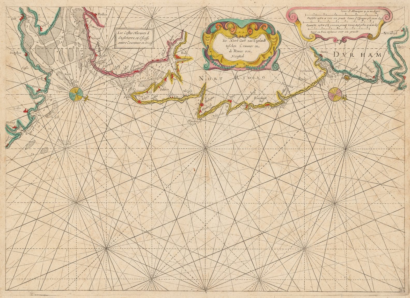
| 12 | (36) | J. Col 9 (11)J. Col 29 (15) | De Noort Cust van Engelandt / tußchen Crammer en / de Revier van / Nicasteel. Add. title: Les Costes Marines d� / Engleterre. et Escosse / entre Crammer et Orcad / es. | 37.5 X 53 cm. | 1º = 205 mm.1:540,000 |
| XII | (37) | J. Col 9 (12)J. Col 29 (14) | De Custen van Engelandt en / Schotlandt tußchen Timbij en~ / de Eijlanden van Orcaneße. | 39.5X 52.5 cm. | 1º = 126 mm.1:880,000 |
| 13/50.51 | (38) | J. Col 9 (13)J. Col 29 (16) | a) Verthooninge vande Eijlanden / Hebrides gelegen achter de / Noordwesthoeck van Schotlandt Add. title cartouche with text erased. b) De Eylanden van, / Hitland Fulo en – / Faijerhil c) De Eylanden / van Fero ofte Farre. / Tot Amsterdam. Bij / Iacob Aertsz. Colom. Koeman notes: “Reengraved plate 16. . .” becomes 13. “. . .without hachures in map borders.” | 16.5 X 52.5 cm.21.5 X 2721.5 X 25 cm. | b) 1º = 184 mm.1:605,000c) 1º = 219 mm.1:505,000 |
[Printed Title Page] The Second Booke [Should read: Second Part] , / of the new, / Fyrie Colomne, / Of the Eastern Navigation. / The Second Part [Should read: Second Booke] / wherein the Description, / Of the/ Zea – Coasts of Norvvay Fin – / marck and Laplandt: Unto the whole White Zea, / from Dronten to Nova Zembla. / Which is seth forth, With previledge of the High, and / Mighty Lords, the States Generall, for 18. yeares. / Being very serving-able for all Mariners and Pilots. / (Printer’s device: coat-of-arms of Amsterdam) / Printed at Amsterdam, / By Iacob Columne, on the Water, in the Firie Columne, / Anno M. DC. XLIX [Title page printed on right verso of chart following: (39)]
| no plate number | (39) | [Untitled: Chart of Northern Scandinavia, frrom the Norwegian coast to Spitzbergen. Diagonal split scale in order to show the entire coast fro Norway to Spitzbergen.] TotAmsterdam / By Iacob Aertsz Colom / Inde Vierige Colom / opt Water. Early state not including inset of Jan Mayen Island as in J. Col 9 (14) | 40 X 55 cm. [shaved inside left margin.] | 1º= 22 mm.1:5 mill. | |
| 16 | (40) | J. Col 7 (16)J. Col 9 (15)J. Col 29 (18) | a) De Custen Van / Noorwegen en Finmar: / ken, tusschen Dronten / en de Noort Caap / Door I.A.Colom. Add. title: Les Costes Marines de Nor: / wegue et Finmarcke entre / Dronten et le Noort Caep b) ‘t Landt / Spitsbergen / Niuwelijckx gevonde c) Ian / Mayen / Eylandt | 38.5 c. X 53.5 cm.13 c. X 24 c. cm.19.7 X 23.5 cm. | a) 1º = 71 mm.1:1.57 mill.b) 1º= 36 mm.1:3.1 mill.c) 1º = 274 mm.1:405,000 |
| 17 | (41) | J. Col 7 (17)J. Col 9 (16)J. Col 29 (19) | a) De Custen van , / Noorwegen, En Laplandt, / Tusschen Noordkijn en Kilduijn. / Iacob Aertsz. Colom b) Inset: De Rivier / van Kola c) Inset: Laplandt / Het Eylandt Kilduijn met de Reede / nae’t leven ontworpen leggende op de / hoochte van 69 graaden 40 minuten d) De Custen van / Laplandt Tusschen / Kilduijn en Swetenoes / Iacob Aertsz. Colom Add. title: Les Costes Marines entre / Noordkijn et Swetenoes. / a Amstel. par Iaques Colom. | 27 X 53.5 cm.18.5 c. X 11 c. cm.8.5 c. X 10 c. cm.11X 53.5 cm. | a) 1º = 187 mm.1:595,000b)1º = 472 mm.1:235,000c)1º = 562 mm.1:200,000d) 1º = 228 mm.1:490,000 |
| 18 | (42) | J. Col 29 (20) | a) Pascaerte / vande / Witte-Zee / Nieulijcx beschrev? / door / Iacob Aertzen Colom Add. title: Carte Marine de la Mer / Blanche. b) Inset: De Riviere Dwina / vande mont of tot de / Stadt Archangel toe. c) Inset: Lombascho / nae’t leu? ontworpen d) Inset:Swetenoes, met de / Eylandekens daer ontrent / gelegen, naet leven ontWorpen, | 37.3 X 52.5 cm.10 c X 32 c. cm.10.4 X 5.6 cm.13.5 X 13.8 cm. | a) 1º =80 mm.1:1.4 mill. |
[Printed Title Page] The Second Booke [Should read: Third Part] , / of the new, / Fyrie Colomne, / Of the Eastern Navigation. / The Third Part [Should read: Third Booke] / wherein the Description, Of the whole / East -Zee. / Which is seth forth, With previledgeof the High, and / Mighty Lords, the States Generall, for 18. yeares. / Being very serving-able for all Mariners and Pilots. / (Printer’s device: coat-of-arms of Amsterdam) / Printed at Amsterdam, / By Iacob Columne, on the Water, in the Firie Columne, / Anno M. DC. XLIX [Title page printed on right verso of chart following: (43)]
| (43) | J. Col 9 (18)J. Col 29 (21) | Pascaerte / vande / Oost – Zee / Nieulix Wtgegeven / Door / Iacob Colom. | 41.5 X 54.5 cm | 1º = 65 mm.1:1.7 mill. | |
| 20 | (44) | J. Col 7 (20)J. Col 29 (22) | De Custen van Schoonen en Swed? / van Valsterboen tot Christianopolis / Bornholm en de Custen van Pomeren / van’t Eylant Rugen tot Rygs-hooft. / Tot Amsterdam / By Jacob Aertsen Colom Add title: Les Costes Marines / de Schoonen et Suede / de Valsterboen à Christ / ianopolis, et Bornholm / et Pomeren de Isle de / Rugen à Rygshooft / Par Iaques Colom. | 37.5 X53 cm. | 1º= 170 mm.1:655,000 |
| (44a) | The New-deepe. Chart of the bay of that name in the island of Rugen in Pomerania. Inset in text on p. 133. | 14.5 X 17 cm. | 1º = 510 mm.1:220,000 | ||
| 21 | (45) | J. Col 7 (21)J. Col 9 (20)J. Col 29 (23) | De / Zeecusten van / Courlant en Pruyssen / Tusschen Derwinde en Rygshooft / Nieuelijks Beschreven bij / Iacob Aersz. Colom. Add. title: Les Costes Marines de / Courlant et Pruijssen de: / puis Rijgshooft jusques / à Derwinda | 37.5 X 53.8 cm. | 1º = 164 mm.1:680,000 |
| 22 | (46) | J. Col 7 (22)J. Col 9 (21)J. Col 29 (24) | Pascaerte vande / Zeecuste van Lyflandt / en / Oost Vinlandt als mede / Dageroort en den Rijgseninham / Nieulijcx Beschreven. / Tot / Amsterdam / bij Jacob Aertsz / Colom . Add. title: Les Costes Marines de / Livonie, et Finlant depue, / Oesel jusques à Wyborgh. | 38 X 53.3 cm. | 1º = 102 mm.1:1.1 mill. |
| Great and final Wranger. Chart inset in text on page 141. | 12.5 X 15.5 cm. | ||||
| N. 23/ 57, 58 | (47) | J. Col 9 (23) | a) De Custen van Sweden / tußchen Calmer en / Landsoort / ‘t gat van Stocholm b) Caarte / van’t / Stocholmse / Liet. | 38.5 X 26 cm.38.5 X 26 cm. | a) 1º = 194 mm.1:575,000 b) 1º = 475 mm.1:235,000 |