John Rocque (properly Jean) was a French Huguenot émigré, one of four children (including three brothers), who seems to have settled in London by about 1709, presumably brought there by his parents. There is little record of his early life. Varley notes an entry on the Oath Roll Naturalisations in 1709 for one ‘John Rocque (Rocques)’, but it is more plausible that it could be John’s father, as Varley suggests John was only about five at this time (1).
In 1728, ‘Jean Rocque’ was godfather to Jean, son of François Vivares, a French engraver, also settled in England. As Vivares was subsequently employed to engrave views for John Rocque, this identification seems more certain. At the time John was married to Marthe. Subsequently, in 1751, he married Ann (Mary-Ann) Bew, who continued the business after his death.
raremaps.com
John worked as a surveyor, engraver, mapmaker, map-seller and publisher, first from ‘The Canister and Sugar Loaf’, in Great Windmill Street, Soho, an area popular with French emigrants. He later moved to ‘Hyde Park Road’, a section of Piccadilly, in those days on the outskirts of London, before moving, in 1750, to larger and more central premises, first in Whitehall, and then in the Strand. A list of addresses from which he and his widow operated is given in Appendix I.
In the early stage of his career, John worked in conjunction with his brother Bartholomew (I), a landscape gardener, although the brothers maintained separate business premises. At the time there was considerable interest among the monarchy and aristocracy in elaborate formal gardens, and it is to be presumed that Bartholomew was employed, in some fashion, in this field. In his earliest plans, John described himself as a ‘dessinateur des jardins’, possibly working with the landscape gardener to sketch out proposed designs to be submitted to the employer, and then preparing a plan of the finished work.
It is interesting that the area of ‘Hyde Park Road’ that he lived in was noted as a centre for dealers in garden statuary, fountains and so on – and this shows further evidence of Rocque’s connection with allied professions. Rocque described himself as living next door to the ‘Duke of Grafton’s Head’, the statuary yard occupied by John Cheere.
Their nephew, Bartholomew (II) (b.1720) was an engraver, who spent much of his life in Germany, working in Mannheim. Two early maps published by John Rocque are signed B. Rocque, one as surveyor and publisher, the other as engraver, the first presumably the work of Bartholomew (I), the second possibly of Bartholomew (II)?
As has been said, Rocque’s earliest published maps were plans of gardens or estates, including properties owned by the crown and some of the leading nobles in Britain. His first, published by John Bowles in 1734, was of Richmond Gardens, now the Royal Botanical Gardens at Kew. Subsequently, he produced fine plans of Windsor Castle, Kensington Palace, Kew Gardens, Sion House, Chiswick House, and so on, issued under his own imprint. These plans give a clear indication of his working methods. Each is dedicated to an influential or wealthy figure, and the implication is that each figure “honoured” in this way would reward Rocque financially not only for the work itself, but also for the prestige it brought.
One explanation for his approach was that map publishing in England at this period was a very problematic business. Too often, mapmakers found that the costs of original survey work could not be recouped by sales of the published piece. The Crown and aristocracy, however, were often willing to underwrite the expense of such surveys.
It was thus that Rocque principally occupied himself between 1734 and 1743. While these plans are eloquent testimony to his abilities as a mapmaker and engraver, as a corpus they would have secured him only a minor position in the history of the map trade in England. However, as his career progressed, and his connections expanded, Rocque branched out into a new field – the surveying of English towns. It was readily apparent that the individual towns of England were poorly mapped, not least London itself. Seizing the opportunity, Rocque commenced preparation of a series of large-scale plans of cities of England and Ireland. In the same way that he capitalised on individual pride for his estate plans, he was able to call on burgeoning civic and local pride for assistance and support in preparing these large-scale plans. Such help was often rewarded in the dedication to the map or in lists of subscribers issued with the plan as can be seen in the dedication to his plan of Bristol, for example, with the accompanying arms of the merchant companies of the city.
In 1737, Rocque embarked upon a survey of London, in conjunction with John Pine, although the scale of the project meant that the survey work was not completed until 1744. In the interval, he published a four-sheet plan of Bath (1743), in association with a local bookseller Benjamin Hickey, who may have commissioned the survey, an elaborate two-sheet plan of Exeter, 1744, and in 1746 a plan of Shrewsbury.
However, Rocque’s previous work could hardly have been sufficient preparation for surveying London. The evident difficulties he had in the survey work, and attendant delays, coupled with his ambitious survey programme of other towns seems to over-extended his limited financial resources. When the map was finally published in October 1746, on 24 sheets, it was issued under the joint imprint of John Pine and the bookseller and publisher, John Tinney, the implication being that Rocque’s share-holding in the plan had passed to Tinney. Rocque’s role was presumably reduced to completing the survey work and revising the plates ready for press, as an employee of the publishers.
However, Rocque’s financial problems, if that should be the case, seem to have short-lived as he published a 16-sheet map of the environs of London in 1746, from survey work done between 1741 and 1745.
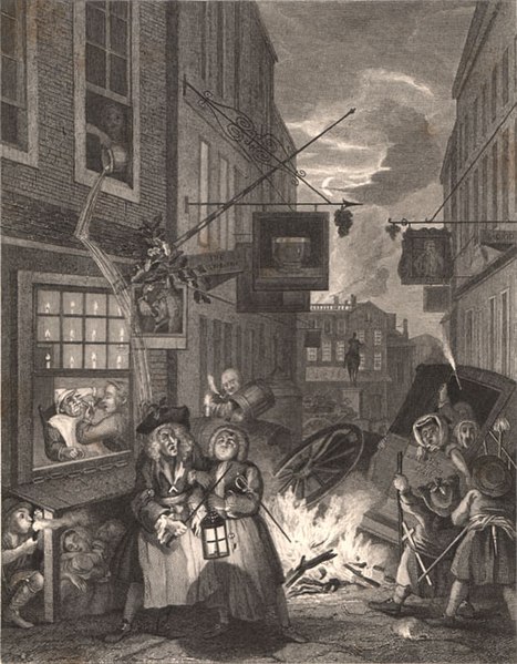
These two survey works seem to have given a considerable boost to Rocque’s fortunes. In 1751 he was appointed Chorographer to the Prince of Wales, while in 1750 he moved to more central, and larger premises, in Whitehall, next to a tavern, called ‘The Rummer.’ The tavern is depicted in William Hogarth’s engraving ‘Night’, from his set of four ‘Times Of The Day’. However, Hogarth has used artistic licence, transposing left and right, and making Whitehall considerably narrower.
However, on the night of November 7th 1750, disaster struck, as the General Advertiser records:
“On Wednesday night between 11 and 12 o’clock, a fire broke out in the house of Mr. Rocque, a draughtsman and printseller, next door to the Rummer tavern Charing Cross, which burn’t with great violence, and, in a short time, entirely consumed that house, together with the Rummer, a silversmith’s shop, a haberdasher’s, and a linen drapers, and did considerable damage to others adjoyning …”
Rocque was undaunted, as an announcement in the London Daily Advertiser, for June 18th 1751 shows:
“John Rocque, Chorographer and topographer to their Royal Highnesses the late and present Prince of Wales, being returned from Paris where he had lately been obliged to renew his stock consumed in the Fire at Charing Cross, begs leave to acquaint his subscribers to the County of Salop, that the plates of that Survey are again in hand, and in good forwardness, and likewise his subscribers to the Counties of Berks, Oxfordshire, and Buckinghamshire, that the actual survey of them is carrying on with all possible care and with such expedition that he hopes by the ensuing winter to produce something for the general satisfaction, both of the said subscribers, and others who may be disposed to favour him in like manner.
N.B. He lives at the corner of Buckingham St. in the Strand, and, as usual, undertakes the land-surveying and planning of gentleman’s estates. He has a great choice of foreign maps, plans, battles, sieges, &c. newly imported, likewise plans of Nimes and Montpelier.”
In a letter of 1753 to his nephew, Bartholomew (II)), who was in Mannheim, John Rocque noted that he employed ten foreigners, “as many draughtsman as engravers”, in his workshop, although he bemoaned the fact that “I have been and am still unfortunate in the foreigners whom I employ” (2). The names of some of these engravers can be seen on Rocque’s maps and views, including Moreau, Aveline, L’Empereur, Chatelain, Deharme, le Parmentier, and J.J Perret.
Two other engravers associated with Rocque are Robert Benning and Peter Andrews. Varley suggests that Benning was a foreigner, and it seems hard to avoid the conclusion that ‘Andrews’ was one and the same as Pierre (Peter) André. Andrews worked for Mary Ann Rocque, engraving some of the maps in the ‘Plans And Forts In America, issued in 1763. When Mary Ann Rocque left business, apparently in 1770, Andrews seems to disappear, while the surveyor, Peter André emerges. As Rocque’s will was witnessed by André, the coincidence seems too great. A further associate of the family was Andrew Dury, also apparently of French Huguenot extraction. Dury seems to have played an important role in assisting Mary Ann Rocque continue her husband’s business, as well as publishing Rocque’s ‘Set Of Plans And Harbours …’
Rocque also employed, or worked with, a number of English engravers, including John Pine, Richard Parr, Isaac Basire (I), Richard William Seale and R. White.
The third phase of Rocque’s career was the publication of a small number of large scale maps of the English counties, including Shropshire, Berkshire, Middlesex and Surrey, the latter published posthumously.
While clearly a man of only relatively modest means, as shown by his will for example, his business must have been very successful. Rocque was one of the only English mapmakers financing original survey work on this scale to escape bankruptcy – an all too common feature of the English map-trade. Thomas Jefferys Sr. who picked up Rocque’s mantle, went bankrupt once, and struggled for much of the latter part of his career. It would seem that the diversity of his output, coupled with him selling up-to-date maps produced by continental and English counterparts, such as Edward Oakley, may have given him an edge over established firms of print and map-sellers, who relied heavily on re-publishing out-dated materials.
It is hard to overstate Rocque’s importance. While other mapmakers had issued such large-scale maps before, no individual had attempted such a broad range. Perhaps more importantly, Rocque began work at a time when English mapmaking was at a low ebb, with much of the material being published being long out of date. His work made an enormous contribution to the impetus for what has been termed the “Remapping of England”.
Noteworthy features of his maps are the much improved, and broadened range of conventional signs that he employed within the maps.
The modern audience is fortunate that Rocque worked at the time that he did. While surveying techniques were becoming more modern, public taste of the period insisted on the inclusion of depictions of the principal buildings. This combination of cartographic and pictorial elements led to the creation of some of the finest plans of English towns ever published.
CATALOGUE OF ENGRAVED WORKS
| 1 | 1734: RICHMOND: state 1 PLAN OF THE HOUSE, GARDENS, PARK, & HERMITAGE / OF THEIR MAJESTIES, AT RICHMOND; / AND OF THEIR R.H. THE PRINCE OF WALES, & THE PRINCESS ROYAL / AT KEW. / PLAN GENERAL DES MAISONS, JARDINS, PARCS, & HERMITAGE, / DE LEURS MAJESTES, A RICHEMOND; / ET DE L.A.R LE PRINCE DE GALLES, & LA PRINCESSE ROYALE / A KEW. / DEDIÉ AU ROI. / Par son tres humble tres obeissant / et tres fidele Serviteur & Sujet / JEAN ROCQUE / dessinateur / de Jardins / 1734. [4e] Printed for Iohn Bowles at the Black Horse in Cornhill. [2e] [Insets] ‘The Queen’s House at Kew. Maison de la Reine a Kew’ [3a] 85 x 75 ‘Summer House in y.e Wood. / Salon dans le Bois’ [3b] 42 x 40 ‘A Plan of the Hermitage / Plan de l’Hermitage’ [3a] 74 x 75 ‘The Hermitage l’Hermitage’ [3b] 99 x 75 ‘The Dairy House. Laiterie’ [3b] 42 x 53 ‘The Green House. L’Orangerie’ [4a] 89 x 122 ‘The South Prospect of His Majesties House at Richmond. Vuë du Pallais Royal du coté du Midi’ [4a-5a] 89 x 235 ‘The North Prospect of HIS MAJESTIES HOUSE AT RICHMOND. Vuë du PALAIS ROYAL du coté du Nord’ [4b-5b] 86 x 362 ‘The South Prospect of HIS ROYAL HIGHNESS THE PRINCE OF WALES’S HOUSE at Kew. Vuë de la Maison DE SON ALTESSE ROYALE LE PRINCE DE GALLES du Coté du Midi’ [4b-5b] 87 x 362 ‘P: Marys Summer House / Salon de la P: Marie’ [4c] 34 x 27 ‘The Summer House to y.e Terrass. / Salon de la Terrasse’ [4c] 48 x 45 ‘The North Prospect of His R: H: the Prince of Wales’s House at Kew. du Coté du Nord’ [5c] 87 x 167 | [key] ‘Refferences of the Figures in this Plan. Renvoy des Chiffres du Plan. / 1-20 / 21-39 / 40-55 / 56-72.’ [in English and French] [1a & 2a] [scale] ‘SCALE / For the Plan of 800 Feet. // ECHELLE / Pour le Plan, de 800 Pieds’ – ‘800’ (78mm) / ‘For the Buildings, of 40 Feet. Pour les Elevations, de 40 Pieds’ – ’40’ (56mm) [2d] [text] ‘Richmond Palace …’ [English & French] 567 x 900 |
| 2 | 1734: RICHMOND: state 2 [1740 ca.] PLAN OF THE HOUSE, GARDENS, PARK, & HERMITAGE / OF THEIR MAJESTIES, AT RICHMOND; / AND OF THEIR R.H. THE PRINCE OF WALES, & THE PRINCESS ROYAL / AT KEW. / PLAN GENERAL DES MAISONS, JARDINS, PARCS, & HERMITAGE, / DE LEURS MAJESTES, A RICHEMOND; / ET DE L.A.R LE PRINCE DE GALLES, & LA PRINCESSE ROYALE / A KEW. / DEDIÉ AU ROI. / Par son tres humble tres obeissant / et tres fidele Serviteur & Sujet / JEAN ROCQUE / dessinateur / de Jardins / 1734. [4e] [Insets] ‘The Queen’s House at Kew. Maison de la Reine a Kew’ [3a] 85 x 75 ‘Summer House in y.e Wood. / Salon dans le Bois’ [3b] 42 x 40 ‘A Plan of the Hermitage / Plan de l’Hermitage’ [3a] 74 x 75 ‘The Hermitage l’Hermitage’ [3b] 99 x 75 ‘The Dairy House. Laiterie’ [3b] 42 x 53 ‘The Green House. L’Orangerie’ [4a] 89 x 122 ‘The South Prospect of His Majesties House at Richmond. Vuë du Pallais Royal du coté du Midi’ [4a-5a] 89 x 235 ‘The North Prospect of HIS MAJESTIES HOUSE AT RICHMOND. Vuë du PALAIS ROYAL du coté du Nord’ [4b-5b] 86 x 362 ‘The South Prospect of HIS ROYAL HIGHNESS THE PRINCE OF WALES’S HOUSE at Kew. Vuë de la Maison DE SON ALTESSE ROYALE LE PRINCE DE GALLES du Coté du Midi’ [4b-5b] 87 x 362 ‘P: Marys Summer House / Salon de la P: Marie’ [4c] 34 x 27 ‘The Summer House to y.e Terrass. / Salon de la Terrasse’ [4c] 48 x 45 ‘The North Prospect of His R: H: the Prince of Wales’s House at Kew. du Coté du Nord’ [5c] 87 x 167 | [key] ‘Refferences of the Figures in this Plan. Renvoy des Chiffres du Plan. / 1-20 / 21-39 / 40-55 / 56-72.’ [in English and French] [1a & 2a] [scale] ‘SCALE / For the Plan of 800 Feet. // ECHELLE / Pour le Plan, de 800 Pieds’ – ‘800’ (78mm) / ‘For the Buildings, of 40 Feet. Pour les Elevations, de 40 Pieds’ – ’40’ (56mm) [2d] [text] ‘Richmond Palace …’ [English & French] 570 x 897 State 2: John Bowles’s imprint has been crudely erased from the plate. |
| 3 | 1734: RICHMOND: state 3 1748 A New PLAN / of / RICHMOND GARDEN / This Survey is Inscrib’d to / Tho.s & Rob.t Greening Esq.rs / By their most Humble Servant / John Rocque / 1748. [1e] ‘The Queen’s House at Kew. Maison de la Reine a Kew’ [3a] 85 x 75 ‘Summer House in y.e Wood. / Salon dans le Bois’ [3b] 42 x 40 ‘MERLIN’S CAVE’ [3a] 75 x 75 ‘The Hermitage l’Hermitage’ [3b] 99 x 75 ‘The Dairy House. Laiterie’ [3b] 42 x 53 ‘The Green House. L’Orangerie’ [4a] 89 x 122 ‘The South Prospect of His Majesties House at Richmond. Vuë du Pallais Royal du coté du Midi’ [4a-5a] 89 x 235 ‘The North Prospect of HIS MAJESTIES HOUSE AT RICHMOND. Vuë du PALAIS ROYAL du coté du Nord’ [4b-5b] 86 x 362 ‘The South Prospect of HIS ROYAL HIGHNESS THE PRINCE OF WALES’S HOUSE at Kew. Vuë de la Maison DE SON ALTESSE ROYALE LE PRINCE DE GALLES du Coté du Midi’ [4b-5b] 87 x 362 ‘P: Marys Summer House / Salon de la P: Marie’ [4c] 34 x 27 ‘The Summer House to y.e Terrass. / Salon de la Terrass e’ [4c] 48 x 45 ‘The North Prospect of His R: H: the Prince of Wales’s House at Kew. du Coté du Nord’ [5c] 87 x 167 ‘A View of the Mount, the Bridge & Richmond Gate.’ [4e] 88 x 171 | [key] ‘Refferences of the Figures in this Plan. Renvoy des Chiffres du Plan. / 1-20 / 21-39 / 40-55 / 56-72.’ [in English and French] [1a & 2a] [scale] ‘SCALE / For the Plan of 800 Feet. // ECHELLE / Pour le Plan, de 800 Pieds’ – ‘800’ (78mm) / ‘For the Buildings, of 40 Feet. Pour les Elevations, de 40 Pieds’ – ’40’ (56mm) [2d] [text] ‘Richmond Palace …’ [English & French] Left sheet: 578 x 455 PM: 592 x 467 Right sheet: 575 x 454 PM: 587 x 465 State 3: The title has been re-engraved. The original title has been replaced by the view of the Mount. Within the map a large number of alterations have been made: a wood, with a path through it, has been added [left sheet, 4d]; ‘The New Mount’ has been added [R: 1d]; ‘The Terras’, no. 39, has been filled in with trees [R: 1c]; a new path has been engraved along the river [1c-4d], extending to Lady Clinton’s house [R: 4d] with a new avenue of trees, one deep on the river side and two deep on the side away from the river, and the original figures and dogs have been erased. The path across the fields and the figures have been erased, and the trees on the river bank have been removed. The grounds of Lady Clinton’s house have been altered [4d]. The view of Merlin’s Cave has replaced the plan of the Hermitage [3a] |
| 4 | 1735: WANSTEAD The / PLAN / of the HOUSE / GARDENS PARK / & PLANTATIONS / of Wanstead in the / County of ESSEX, / The Seat of the R.t / Hon:ble the E.l TYLNEY. [4a] Maisons et Jordins de / Monsieur le Conte Tylney / Situé dans le Conte de Essex a 2 / Lieves de Londres, Levé Dessienné / et Grave par J. Rocque. 1735. [4b] [Insets] ‘Wanstead House’ 150 x 753 [1a-4a] ‘The Little Amphiteather’ 129 x 147 [1b] ‘The Fortifications’ 129 x 156 [2b] ‘The Mount in the Great Lake’ 129 x 204 [2b-3b] [Untitled Drive Through The Trees] 130 x 187 [3b-4b] ‘The Gardners House’ 73 x 155 [1c] ‘The Mounts’ 107 x 116 [1d] ‘The Water House’ 74 x 116 [1d] ‘The Stove House’ 90 x 148 [1e] ‘The Green House’ 90 x 220 [2e] ‘The Great Stove House’ 91 x 140 [2e-3e] | |
| 5 | 1735: WREST A / PLAN & VIEW of the BUILDINGS & GARDEN / AT REST / the Seat of his Grace / The DUKE of KENT in Bedfordshire / To the most Noble Prince / HENRY DUKE of KENT, &c. &c. / This Plan is most hum:bly Inscrib’d / by his Graces most Devoted, & / Obed.t hum.ble Serv.t / Jn.o Rocque. / 1735. [1d] Maisons et Jardins du / Duc de Kente Situé a Rest a 13 lieues de / Londres dans le Conté de Bedford / Levé dessienné et Gravé par Jean Rocque. [2d] [Insets] ‘The North Prospect of Bell House’ [1a/b- 3a/b] 175 x 475 ‘The West Prospect of Hill House’ [1b] 127 x 202 ‘The Plan of Hill House’ [2b] 127 x 156 ‘The North Prospect of Pauillion House’ [1e] 163 x 192 ‘The West Prospect of y.e Bowling Green House’ [2e-3e] 92 x 178 ‘The Plan of the Bowling Green House’ [3e] 93 x 128 ‘The East Prospect of y.e Bowling Green House’ [2e-3e] 93 x 199 ‘The Obelisk’ [5a] 160 x 104 ‘Dianas Temple’ [5b] 113 x 127 ‘The Alcove Seat in my Lady Dutchess Walk’ [5c] 67 x 155 ‘The Plan of the Pavil lion House’ [5d] 97 x 154 ‘The South Prospect of Pauillion House.’ [5e] 165 x 155 | [key] ‘REFERENCE. / 1-16 // [vertical rule] // REFERENCE. / 17-32.’ [in English] [2e] [scale] ‘Scales / for the Plan.’ – ‘400 Feet’ (76mm) / ‘for the Buildings’ – ’50 Feet’ (78mm) [2d] 630 x 1009 2 sheets joined |
| 6 | 1736: CHISWICK HOUSE: state 1 Plan du Jardin & Vuë des / Maisons de Chiswick, Sur la / Tamise a deux Lieves de Londres / Dedié / A Tres Haut et Tres Puissant / Seigneur RICHARD BOYLE / Comte de Burlington de Cork, &c. &c. / Par son tres humble et tres Obeissant / & tres obligé Serviteur / J. Rocque. [2b] J: Rocque del: et sculp. [5e, ob] Publish’d pursuant to an Act of Parliament 1736 / Sold by the Proprietor at y.e Canister and Sugar Loaf in Great Windmill S.t Jame’s. London. [2c] [Insets] ‘Arriere Facade du meme Pavillon’ [1a] 97 x 135 ‘Pavilion au pres du Pont’ [2a] 96 x 126 ‘La Cascade’ [3a] 95 x 122 ‘L’Orangerie’ [4a-5a] 102 x 368 ‘Arc Rustique’ [1e] 115 x 104 ‘Façade de la Maison du Coté de la Riviere’ [2e] 115 x 195 ‘Façade du Coté de la Cour’ [3e] 115 x 219 ‘Façade du Coté du Jardin’ [4e-5e] 114 x 236 ‘Façade du Temple’ [1b] 117 x 103 ‘La Voliere’ [1c] 105 x 102 ‘Façade du Temple du Coté de la Riviere’ [5a, orb] 127 x 106 ‘Pavillon au pres de la Riviere’ [ 5c, orb] 122 x 106 ‘Pavillon au bout de la Grande Allée.’ [5e, orb] 118 x 105 | [scale] ‘Echelle de 400 pieds’ – ‘400 feet’ (114mm) [2c] W: 410 x 663 B: 602 x 770 PM: 615 x 785 |
| 7 | 1736: CHISWICK HOUSE: state 2 [1750 ca.] Plan du Jardin & Vuë des / Maisons de Chiswick, Sur la / Tamise a deux Lieves de Londres / Dedié / A Tres Haut et Tres Puissant / Seigneur RICHARD BOYLE / Comte de Burlington de Cork, &c. &c. / Par son tres humble et tres Obeissant / & tres obligé Serviteur / J. Rocque. [2b] J: Rocque del: et sculp. [5e, ob] Publish’d pursuant to an Act of Parliament 1736. [2c] [Inset] ‘Arriere Facade du meme Pavillon’ [1a] 97 x 135 ‘Pavilion au pres du Pont’ [2a] 96 x 126 ‘La Cascade’ [3a] 95 x 122 ‘L’Orangerie’ [4a-5a] 102 x 368 ‘Arc Rustique’ [1e] 115 x 104 ‘Façade de la Maison du Coté de la Riviere’ [2e] 115 x 195 ‘Façade du Coté de la Cour’ [3e] 115 x 219 ‘Façade du Coté du Jardin’ [4e-5e] 114 x 236 ‘Façade du Temple’ [1b] 117 x 103 ‘La Voliere’ [1c] 105 x 102 ‘Façade du Temple du Coté de la Riviere’ [5a, orb] 127 x 106 ‘Pavillon au pres de la Riviere’ [5c, orb] 122 x 106 ‘Pavillon au bout de la Grande Allée.’ [5e, orb] 118 x 105 | [scale] ‘Echelle de 400 pieds’ – ‘400 feet’ (114mm) [2c] Widest: 410 x 663 B: 602 x 770 PM: 615 x 785 State 2: with the second line of the imprint erased. The impression is much weaker. There are no apparent differences in the plan. |
| 8 | 1736: CHISWICK HOUSE: state 3 [1760 ca.] A Plan of the House & Gardens of / his Grace the DUKE of DEVONSHIRE at / CHISWICK, / Embellished with Views of that magnificent Structure, / and of the several Temples & Other Ornaments, / with References to their respective Situations in the Plan. / BY / J. Rocque. [2b] Printed for T. Kitchin N.o 59, Holborn Hill, London. [2c] [Insets] ‘Arriere Facade du meme Pavillon’ ‘Back Front of the same Summer House’ [1a] 97 x 135 ‘Pavilion au pres du Pont’ ‘Summer House near the Bridge.’ [2a] 96 x 126 ‘La Cascade’ ‘The Cascade’ [3a] 95 x 122 ‘L’Orangerie’ ‘The Orangery’ [4a-5a] 102 x 368 ‘Arc Rustique – The Rustick Arch’ [1e] 115 x 104 ‘Façade de la Maison du Coté de la Riviere – Front of the House from the River’ [2e] 115 x 195 ‘Façade du Coté de la Cour – From from the Cout Yard ‘ [3e] 115 x 219 ‘Façade du Coté du Jardin – Front from the Garden’ [4e-5e] 114 x 236 ‘Façade du Temple’ ‘Front of the Temple’ [1b] 117 x 103 ‘La Voliere’ ‘The Av iary’ [1c] 105 x 102 ‘Façade du Temple du Coté de la Riviere’ ‘Front of the Temple from the River’ [5a, orb] 127 x 106 ‘Pavillon au pres de la Riviere’ ‘Summer House near the River.’ [5c, orb] 122 x 106 ‘Pavillon au bout de la Grande Allée.’ ‘Summer house at the End of the Great Walk’ [5e, orb] 118 x 105 | [scale] ‘Scale of Feet’ – ‘400 feet’ (115mm) [2c] W: 415 x 661 B: 608 x 770 PM: – x 783 State 3: the title has now been re-engraved in English, and English titles added to the insets. Rocque’s signature has been erased, and Kitchin’s inserted. |
| 9 | 1736: HAMPTON COURT [Untitled Plan Of Hampton Court] To His / Royal Highness / FREDERICK / PRINCE of WALES / This Plan of y.e Royal / Palace and Gardens of / Hampton Court is most humbly / Inscrib’d by His Highness’s most / Obedient Servant J: Rocque. / Plan du Palais et Jardin de Hampton / Court Sur la Tamise a 5 Lieües de Londres / Dedié / a S:A:R: Mon Seigneur le Prince / de Galles par Son tres humble / et tres Obeissant Serviteur / J. Rocque. [5d] Sold by J. Rocque at y.e Green Cannister in / Great Windmill Street S.t James’s. [2e, ob] Publish’d pursuant to an Act / of Parliament 1736. [3e, ob] | [key] ‘1-10 / 11-20’ [English with French equivalents] [4e] [scale] ‘Scale of 600 feet’ – ‘600 pieds’ (119mm) [2d] IB: 438 x 498 B (w): 463 x 515 PM: 467 x 524 |
| 10 | 1736: KENSINGTON PALACE Plan General du Palais & Jordins de / Kensington Situé dans le Conté de Middlesex a 2 Miles / de Londres tres Exactement Levé dessiené & Gravé par / Jean Rocque 1736. [5d] To the QUEEN’S most EXCELLENT / MAIESTY, This PLAN of y.e ROYAL PALACE / and GARDENS of KENSINGTON. / Is most humbly Inscrib’d by your / Majesty’s most Dutiful Loyal & / Obedient Subject John Rocque. [3e] Survey’d Drawn Engrav’d and / Publish’d according to Act of Parliament / by Iohn Rocque. [2e] Sold at the Cannister / & Sugar Loaf in Great / Windmill Street / S.t James’s London. [2d] | [key, in English] ‘1-8 / 9-16.’ [2d] [key, in French] ‘1-7 / 8-15.’ [5e] [scale] ‘A scale of Feet’ – ‘900’ (113mm) [4d] 528 x 655 |
| 11 | 1736: RICHMOND Plan of the House Gardens Park & Hermitage of their / Majesty’s at Richmond & the Prince of Wales’s at Kew. / To the Most Puissant Prince CHARLES LENOX / DUKE of RICHMOND Knight of the most Noble / Order of the GARTER &c. &c. / This Plan is most humbly dedicated / By Your Graces Most Obedient humble / Servant J. Rocque. [4b] Plan General du Palais / Jardin Parc & Hermitage de Richmond / Située dans le Conté de Surry a 3 lieües de Londres Levé Desseinné et / Gravé par J. Rocque 1736. [3a] Sold by J. Rocque at the / Canister & Sugar Loaf / in Great Windmill / Street, S.t James’s / London. [3b] [Insets] ‘The Hermitage L’Ermitage’ [1e] 102 x 176 ‘The Dairy house Laiterie.’ [3e] 103 x 220 ‘Merlins Cave Grote de Merlins le Napolitin’ [5e] 103 x 176 | [key] ‘1-21’ [in English and French] [3b] [scale] ‘Scale’ / ‘Echele de 1500 Pieds’ – ‘1500 feet’ (111mm) [5b] IB: 325 x 589 B: 437 x 593 PM: 442 x 598 |
| 12 | 1737: ESHER A / PLAN of the Gardens & / View of y.e Buildings of y.e R.t / Hon:ble HENRY PELHAM Esq; / at Echa in y.e County / of Surry. / Survey’d & Engrav’d / by J. Rocque / 1737. [1e] Plan du Jardin & / Vües des Maisons de M.r / Henry Pelham, a Echa / dans la Conté de Surry a / 5 Lieües de Londres tres Exactement / levé et Gravé par J: Rocque. [2d] Publish’d According to Act of Parliament 1737. [1e, ob] [Inset] ‘Temple’ [1a, olb] 105 x 130 ‘Grotto’ [1b, olb] 103 x 130 ‘Hermitage’ [1c, olb] 118 x 128 ‘Thatch’t House’ [1e, olb] ‘The West Front.’ [1a, ob – 3a, ob] 160 x 233 ‘The East Front’ [3a, ob – 5a, ob] 159 x 263 | [scale] ‘A Scale of 5 Chains or 330 feet’ – [5 chains] (60mm) [2e] 293 x 500 B: 457 x 631 W: 465 x 631 |
| 13 | 1737: Bartholomew ROCQUE OATLANDS A PLAN / of the Garden & House of the R.t / Honourable y.e EARL of LINCOLN / at Weybridge in the County / of SURREY / Survey’d and Engraved by / B. ROCQUE / 1737. [1a] Publish’d According to Act of Parliament 1737. [1e, ob] [Inset] [Untitled View Of The Front Of The House] [3a/b – 5a/b] 155 x 342 | [key] ‘1-12’ [1d] [scale] ‘Scale of 5 Chaines or 330 feet’ – [1] – [0] – ‘5’ (5: 62mm) / ‘Links’ ‘100’ – ’50’ – [0] (13mm) [2b] 460 x 632 PM: 473 x 649 |
| 14 | 1737: SOUTH DALTON [Untitled Plan Of South Dalton] To the Hon:ble S:r CHARLES HOTHAM Bar:t Coll: of y.e / first Troop of Horse Grenadier Guards, Groom of y.e Bedchamber / to his MAIESTY, and MEMBER OF PARLIAMENT / for the Borough of BEVERLY. / This Plan & Elevations of your Hon:rs Seat of South Dalton in the County / of York, is most humbly Inscrib’d by your Hon.rs Most Obedient / Humble Servant John Rocque. [1e] Surveyed & Engraved by John Rocque, & Published Feb.y y.e 24.th 1737. According to Act of Parliament / Sold at y.e Canister in Windmill Street S.t James’s London. [3e] [Inset] ‘THE PAUILION’ 162 x 315 [1a/b – 3a/b] ‘THE HOUSE’ 163 x 311 [3a/b-5a/b] | [no key] [scale] ‘Scale of British feet for y.e Plan’ – ‘100’ – [0] – ‘600’ (600: 106mm) / ‘Scale of feet for y.e House’ – ’10 – [0] – ’60’ (60: 90mm) / ‘Scale of feet for y.e Pavilion’ – ’10’ – [0] – ’20’ (20: 67mm) [5e] 287 x 630 W: 289 x 630 B: 430 x 630 |
| 15 | 1737: WREST A / PLAN & VIEW of the BUILDINGS & GARDEN / AT REST / the Seat of his Grace The DUKE of KENT in Bedfordshire. / To the most Noble Prince HENRY DUKE / of KENT, &c. &c. This Plan is most hum.bly / Inscrib’d by his Graces / most Devoted and Ob.t hum: S.t / In.o Rocque. [4d] Maisons et Jordins du / Duc de Kente Situé a / Rest a 13 lieues de Londres dans le Conte / de Bedford. Levé dessienneé et Gravé par Jean Rocque. [3d] Sold by J: Rocque at the Cannister in Great Windmill Street S.t James. [2e, ob] Publish’d According to an Act of Parliament 1737. [4e, ob] [Insets] ‘The East View of the Pavillion’ [1a] 116 x 202 ‘The Rest House’ [2a-4a] 113 x 334 ‘The North View of the Pavillion’ [5a] 115 x 198 ‘The Alcove Seat in the Lady Dutches’s Walk’ [1b] 107 x 115 ‘The Hill House’ [1c] 99 x 114 ‘Diana’s Temple’ [1d] 138 x 119 ‘The Obelisk’ [5b] 115 x 198 ‘The Duke’s Square’ [5c] 127 x 114 ‘The Lady Dutches’s Square’ [5d] 114 x 115 ‘The East View of the Bowling Green H ouse’ [1e] 117 x 191 ‘The Green House’ [2e-4e] 118 x 367 ‘The West View of the Bowling Green House’ [5e] 117 x 170 | [no key] [scale] ‘Scale for y.e Plan’ – ‘600 feet’ (110mm) / ‘Scales for y.e Buildings’ -’90 feet’ (96mm) [3d] 363 x 504 B: 594 x 737 |
| 16 | 1738: CLAREMOUNT: state 1 PLAN / Du Jardin et parc de Claremount / a 15 Milles de Londres une des / maions du DUC de NEWCASTLE / tres Exa[c]temente levé et Gravé par / J: Rocque 1738. [1c] To the Right Puissant and / Most Noble Prince, THOMAS HOLLES / PELHAM, Duke of Newcastle, / Knight of the Most Noble Order of / y.e Garter, and one of his Majesty’s / Principal Secretaries of State, &c: &c: &c: This / Plan of Claremount is hum.bly / Inscrib’d by his Grace’s most / Obe.t hum:ble Ser.t / J: Rocque. [4b] [Insets] ‘The Amphitheater’ 166 x 185 [1e] ‘The House’ 169 x 609 [2e-4e] ‘The Nine Pin Alley’ 133 x 180 [5a] ‘The Temple’ 133 x 178 [5b] ‘The Bowling Green House’ 133 x 177 [5c] ‘The Alcove’ 132 x 178 [1d] ‘M.r Greenings House.’ 132 x 176 [5e] | [key] ‘1-15.’ [1b] [scale] ‘Scale of 8 Chains for the Plan’ – ‘8’ (99mm) / ‘Scale of Yards for the Plan’ -‘200 Yards’ (113mm) / ‘Scale of feet for the buildings A’ – ’50 feet’ (91mm) / ‘Scale of feet for the Buildings B’ – ’20 feet’ (99mm) [1d] 510 x 801 B: 681 x 979 W: 687 x 979 State 1: In the upper left corner is shown the ‘Guilford Road’ [1b & 3b]. Above the road is a hill [1a] |
| 17 | 1738: CLAREMOUNT: state 2 PLAN / Du Jardin et parc de Claremount / a 15 Milles de Londres une des / maions du DUC de NEWCASTLE / tres Exa[c]temente levé et Gravé par / J: Rocque 1738. [1c] To the Right Puissant and / Most Noble Prince, THOMAS HOLLES / PELHAM, Duke of Newcastle, / Knight of the Most Noble Order of / y.e Garter, and one of his Majesty’s / Principal Secretaries of State, &c: &c: &c: This / Plan of Claremount is hum.bly / Inscrib’d by his Grace’s most / Obe.t hum:ble Ser.t / J: Rocque. [4b] [Insets] ‘The Amphitheater’ 166 x 185 [1e] ‘The House’ 169 x 609 [2e-4e] ‘The Nine Pin Alley’ 133 x 180 [5a] ‘The Temple’ 133 x 178 [5b] ‘The Bowling Green House’ 133 x 177 [5c] ‘The Alcove’ 132 x 178 [1d] ‘M.r Greenings House.’ 132 x 176 [5e] ‘The New House’ 91 x 115 [1a] | 509 x 801 B: 680 x 979 W: 687 x 979 State 2: The hill in the upper left corner has ben replaced by an inset view of ‘The New House’. The hatching for the field around has been completely re-engraved, and the uppermost verge of the road has been altered. Although difficult to establish priority, the tails of the erased letters ‘G’ and ‘f’ (of ‘Guilford’) are just visible in the lower verge of the road, 51mm and 65mm from the left hand border, along the road. ‘Road’ remains [3b]. The plan itself seems to be unchanged. |
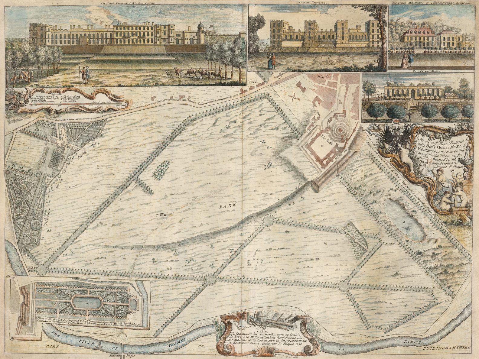
| 18 | 1738: WINDSOR CASTLE PLAN / Du Chateau et Parc de Windsor dans la Conté / de Berk. a 20 Milles de Londres Renferment une / des maisons et Jardins du DUC de MARLBOROUGH. / tres Exa[c]tement Levé et Gravé par J: Rocque 1738. [3e] To the most High Puissant & / Noble Prince Charles DUKE of / MARLBOROUGH &c: &c: &c: This / Plan of Windsor Park is most / hum:bly Inscrib’d by his / Graces most Devoted and Obe:t / Servant J: Rocque. [5c] [Insets] ‘Plan of the Garden as proposed to be / Executed in the Reign of Queen Ann // Plan du Jardin qui a eté projeté du Regne de la Reine / Anne, donc la Piece D’Eau B. et les 2 Allés D’Arbres C. ont eté fait.’ ib (w): 81 x 186 [1d] ‘The North Prospect of Windsor Castle.’ 108 x 321 [2a, ob; 1a-3a] ‘The West Prospect’ 89 x 186 [4a, ob; 4a] ‘His Grace the Duke of Marlborough’s Lodge’ 86 x 117 [5a, ob; 5a] ‘The Green House’ 66 x 151 [4b-5b] | [key] ‘Refferences. / 1-3 / 4-7.’ [1b] [scale] ‘Scale of 1500 feet’ – ‘1500 pieds’ (122mm) [1b] 372 x 621 B: 462 x 621 PM: 473 x 638 |
| 19 | [1740 ca.: DRUMLANGRIG] A / Plan of y.e Garden / & Plantation of DRUMLANGRIG / in SCOTLAND, The Seat of his / Grace y.e Duke of QUEENSBURRY. / To the most Noble Prince CHARLES Duke of QUEENSBURRY & DOVER &c. / This Plan is most humbly / Inscrib’d by his Graces most / humble Servant J. Rocque. [5a] B: Rocque sculp. [5e, ob] [Insets] ‘The Cascade’ 167 x 222 [1a/b – 2a/b] ‘The West Front’ 150 x 221 [1c-2c] ‘The North Front of Drumlangrig House’ 150 x 329 [1e, ob – 3e, ob] ‘The South Front’ 149 x 333 [3e, ob – 5e, ob] | [key] ‘1-12’ [5d] [scale] ‘Scale of feet’ – ‘1000’ [5e] 413 x 445 B: 563 x 666 W: 566 x 666 |
| 20 | 1742: CONSTANTINOPLE A Plan of / CONSTANTINOPLE. / Publish’d by I. Rocque According to / Act of Parliament 1742. [3e, ob] Moreau sculp. [5e, ob] [Insets] ‘View of CONSTANTINOPLE from y.e HELESPONT. [1a/b-2a/b] 105 x 136 ‘The South PROSPECT of the GREAT S.t SOPHIA. [key] ‘A-D.’ [2a/b – 4a/b] 106 x 147 ‘PLAN OF THE GREAT S.t SOPHIA.’ [key] ‘A-I, K-P.’ [scale] ‘Scale of Feet’ – ‘120’ (27mm) [4d-5d] 91 x 133 | [key] ‘1-6 / 7-12 / 13-18 / [18 cont.] – 19-23 / 24-29 [1e, ob – 2e, ob] 30-35 / [35 cont] – 36-39 / 40-45 / 46-50 / [50 cont] – 51-54.’ [4e, ob – 5e, ob] [scale] ‘Scale of English Miles’ – ‘6’ (103mm) / ‘Echelle de 2 lieues d’une heure de chemin’ – ‘2’ (101mm) 329 x 427 W: 342 x 427 PM: – x 439 |
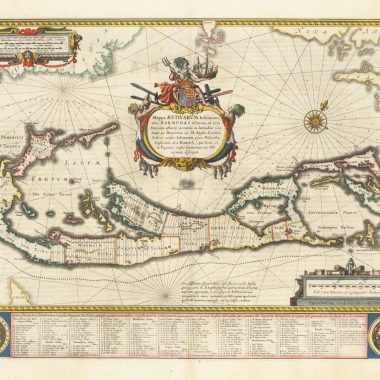
| 21 | 1743: BRISTOL A / PLAN / OF THE / CITY / OF / BRISTOL / Survey’d and Drawn by JOHN ROCQUE / Engrav’d by JOHN PINE. / MDCCXLII. [4b] To the Right Worshipful S.r Abraham Elton Bar.t MAYOR, the Worshipful the Recorder & Aldermen, the Sheriffs & COMMON -COUNCIL-MEN of the CITY of BRISTOL; & also to the Worshipful the Master, Wardens, Assistants, & Commonalty of the Society of Merchants Adventurers in the same CITY, this PLAN is most Humbly Dedicated by / Their most Obliged & Most Faithful Humble Servant Benjamin Hickey. [1e, ob – 5e, ob] Publish’d March 1743, according to Act of Parliament and Sold by the Proprietor Benjamin Hickey Bookseller in Bristol; J. Leake, Bookseller in Bath; J. Pine, Engraver in Old Bond Street, and the Printsellers in London & J. Rocque Surveyor in High Park Road. [2e, ob – 4e, ob] [Inset] ‘The Elevation of the South Front of the Exchange’ [1d] ib: 148 x 228 ‘The Elevation of the North Front of the Exchange’ [5d] 147 x 228 | [scale] ‘Scale of Feet’ – [100] – [0] – ‘600’ (72mm) / ‘Perches’ – [10] – [0] – ’40’ (77mm) / ‘Yards’ – ‘200’ (73mm) / ‘One Furlong’ (81mm) [2d] [text] ‘The CITY of BRISTOL …’ [5d] IB: 986 x 1136 B: 1037 x 1182 W: 1068 x 1205 PM: 1080 x 1210 4 sheets joined |
| 22 | [1743]: ENVIRONS OF SYON HOUSE 1st issue [Untitled Map Centred On Syon House] R. Parr sculp. [5e, ob] [set above] PROPOSALS, / BY / John Rocque, Land-Surveyor, / For ENGRAVING and PRINTING by SUBSCRIPTION, / A New and Accurate MAP of the Country adjacent to the CITIES and LIBERTIES / Of LONDON, WESTMINSTER, and BOROUGH of SOUTHWARK; / From an Exact SURVEY thereof, begun in 1741, and now finished. / The Engraving is now in Hand, and the whole will be finished with all possible Expedition. / … | [key] ‘Scale of half a Mile’ – [no numerals / graduations] (65mm) [3e, ob] 185 x 252 PM: 190 x 256 Page: 442 x 255 Extent: West to East: ‘ISLEWORTH’ to ‘KEW GREEN’; North to South: ‘BRENTFORD’ – ‘PART OF THE DEER PARK’ [Old Deer Park] |
| 23 | [1743]: ENVIRONS OF SYON HOUSE second issue 1744 [Untitled Map Centred On Syon House] R. Parr sculp. [5e, ob] [set above] PROPOSALS, / (By JOHN ROCQUE, LAND-SURVEYOR) / For ENGRAVING and PRINTING by SUBSCRIPTION, / A NEW and ACCURATE MAP of the Country adjacent to the / Cities and Liberties of LONDON, WESTMINSTER, and Borough of SOUTHWARK; / From an exact SURVEY thereof, begun in 1741, and now finished. / The ENGRAVING is now in Hand, and the whole will be finished with all possible Expedition. / … | [scale] ‘Scale of half a Mile’ – [no numerals / graduations] (65mm) [3e, ob] 185 x 252 PM: 190 x 256 Page: 442 x 255 This second version has the text reset, referring to the engraving of four of the sheets, in 1744. |
| 24 | 1744: EXETER Plan de la Ville et faubourgs D’EXETER, tres Exactement Levé & dessiné par I. Rocque. [4d] TO THE / Right Worshipfull y.e Major, Aldermen & Common Council / of the City of Exeter, / This Plan of the said City is humbly Dedicated, / by their most Obedient Servant, / Iohn Rocque. 1744. [2b] R: White Sculp. [1e, ob] Publish’d according to Act of Parliament 1744. [4d] [Insets] ‘EXE BRIDGE’ ib: 163 x 384 [2a, ob; 1a-2a] ‘The North Prospect of the Cathedral Church of S.t Peter.’ 183 x 265 [4a, ob; 3a-4a] ‘THE WORK HOUSE.’ 162 x 228 [4a, ob 4a-5a] ‘THE GUILD HALL.’ 119 x 100 [1b] ‘The West Prospect of the Cathedral Church of S.t Peter.’ 123 x 202 [1c-2c] ‘The North View of the Castle.’ 112 x 167 [1d] ‘The CITY HOSPITAL.’ 150 x 269 [2e, ob; 1e-2e] ‘The City and County Hospital which is now Finished as far as from A to B.’ 150 x 237 [2e, ob; 2e ] ‘The Prospect of the Custom House from Trew’s Ware.’ 159 x 409 [4e, ob; 4e-5e] | [scale] ‘Scale of Quarter Mile’ [no units, no numbers] (164mm) / ‘A Scale of Feet’ – [100] – [0] – ‘1000’ (1000: 136mm) / ‘Scale of Yards’ – ‘300’ (112mm) / ‘Scale of Perches’ – [10] – [0] – ’30’ (30: 64mm) / ‘Scale of Chains’ – ‘5’ (41mm) IB: 688 x 1119 B (w): 745 x 1177 |
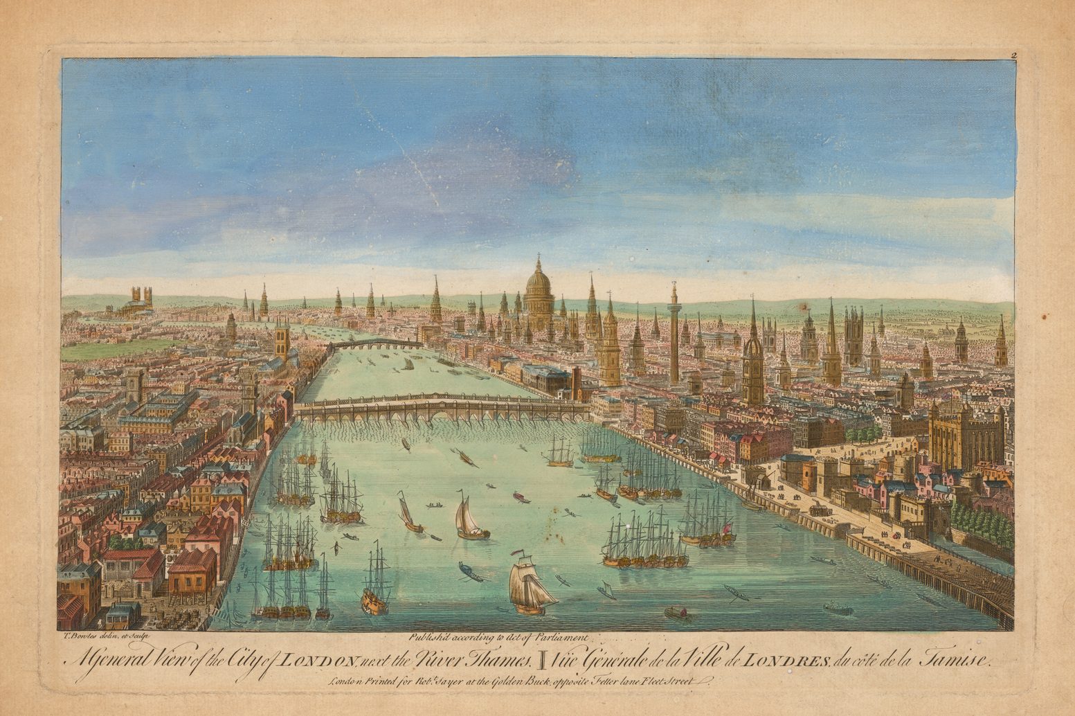
| 25 | 1746: LONDON Environs State 1 Accurata Descriptio URBIUM LONDINENSIS et WESTMONASTERIENSIS, nec non MUNICIPII SOUTHWARK- / ENSIS, et universæ REGIONIS ad decem ferè undique Millia passuum, incepta Anno 1741 et absoluta Anno 1745 IOANNE ROCQUIS Topographo. [sheet XIII: 1e, ob -5e, ob] An Exact Survey of the CITY’S of LONDON, / WESTMINSTER y.e Borough of SOUTH.W.ARK and the // COUNTRY NEAR TEN MILES ROUND BEGUN IN 1741 & ENDED IN 1745 / BY JOHN ROCQUE LAND SURVEYOR & ENGRAU’D BY RICHARD PARR. [sheet XII: 1a, ob – 5a, ob & sheet V: 1a, ob – 5a, ob] CARTE Topographique des VILLES de LONDRES et de WESTMINSTER, du BOURG de SOUTHWARK, / et de Leurs Environs Levè tres exactement sur les lieux par JEAN ROCQUE en 1741, et finis en 1745. Publiè en 1746, selon une Acte de Parlement [sheet IV: 1a, ob – 5a, ob] R. Parr [or slightly variation, usually 5e, on most sheets] To the Right Honourable / Richard Boyle, / Earl of Burlington & Cork, Viscount Dungarvon / Baron Clifford of Lanesborough and Baron Boyle of Donghall, / One of his Majesty’s most honorable Privy Council, / And Knight of the Most Noble Order of the Garter. / this Map is humbly Dedicated by / His Lordships, / Most obedient and / humble Servant / J: Rocque. [sheet IX: 5e & sheet VIII: 1e] Published by J. Rocque According to Act of Parliament Feb.y 13.th 1744. Next y.e Duke of Graftons Head Hide Park Corner. / Where may be had the Plans of the large Survey of London, Bristol, Exeter, Lyon, and of some Noblemens Gardens &c. by y.e said J. Rocque. [sheet 1: 4e, ob – 5e, ob] Publish’d 29.th of April according to Act of Parliament by John Rocque 1746. [sheet 6: 3e, ob] | [key] ‘Explanation to the Plan’ [sheet 1: 2e, ob] [key to positioning of the plates] [sheet 1: 3e, ob] [scale] ‘Woesrt de Moscovie’ [no graduations; no numerals] / ‘Demie Lieue Parisienne’ – ‘1000 Toises’ (163mm) / ‘Quart de Lieuë de 20 au degré’ [no graduations, no numerals] (114mm) / ‘Quart de lieuë de Suede de Dannemarck et de Suisses’ [no graduations; no numerals] (171mm) [sheet 16: 1e, ob – 5e, ob] ‘Scale of Feet’ – [1000] – [0] – ‘5000’ (5000: 124mm) / ‘Scale of Chains’ – [10] – [0] – ’70’ (70: 113mm) / ‘Scale of Yards’ – ‘2000’ (147mm) [sheet IX: 2e, ob – 4e, ob] ‘Mille d’Italie’ [no graduations; nu numerals] (135mm) / ‘Quart de Mille de Hollande’ [no graduations, no numerals] (118mm) / ‘Quart de Lieue D’Espagne’ [no graduations, no numerals] (116mm) / ‘Quart de mille de Pologne’ [no graduations, no numerals] (103mm) / ‘Quart de mille Commun D’Allemagne’ [no graduations, no numerals] (136mm) [sheet VIII: 1e, ob – 5e, ob] / ‘Scale of one Mile’ – ‘8 furlongs’ (130mm) / ‘Scale of Perches’ – ‘200’ (82mm) [sheet 1: 4 e, ob] 16 sheets, approx 485 x 660 Howgego, London, 94 (1). |
| 26 | 1746: LONDON Environs State 2 1747 Accurata Descriptio URBIUM LONDINENSIS et WESTMONASTERIENSIS, nec non MUNICIPII SOUTHWARK- / ENSIS, et universæ REGIONIS ad decem ferè undique Millia passuum, incepta Anno 1741 et absoluta Anno 1745 IOANNE ROCQUIS Topographo. [sheet XIII: 1e, ob -5e, ob] An Exact Survey of the CITY’S of LONDON, / WESTMINSTER y.e Borough of SOUTH.W.ARK and the // COUNTRY NEAR TEN MILES ROUND BEGUN IN 1741 & ENDED IN 1745 / BY JOHN ROCQUE LAND SURVEYOR & ENGRAU’D BY RICHARD PARR. [sheet XII: 1a, ob – 5a, ob & sheet V: 1a, ob – 5a, ob] CARTE Topographique des VILLES de LONDRES et de WESTMINSTER, du BOURG de SOUTHWARK, / et de Leurs Environs Levè tres exactement sur les lieux par JEAN ROCQUE en 1741, et finis en 1745. Publiè en 1746, selon une Acte de Parlement [sheet IV: 1a, ob – 5a, ob] R. Parr [or slightly variation, usually 5e, on most sheets] To the Right Honourable / Richard Boyle, / Earl of Burlington & Cork, Viscount Dungarvon / Baron Clifford of Lanesborough and Baron Boyle of Donghall, / One of his Majesty’s most honorable Privy Council, / And Knight of the Most Noble Order of the Garter. / this Map is humbly Dedicated by / His Lordships, / Most obedient and / humble Servant / J: Rocque. [sheet IX: 5e & sheet VIII: 1e] Published by J. Rocque According to Act of Parliament Feb.y 13.th 1744. Next y.e Duke of Graftons Head Hide Park Corner. / Where may be had the Plans of the large Survey of London, Bristol, Exeter, Lyon, and of some Noblemens Gardens &c. by y.e said J. Rocque. [sheet 1: 4e, ob – 5e, ob] Publish’d 29.th of April according to Act of Parliament by John Rocque 1746. [sheet 6: 3e, ob] [Bound volume with title] ‘An Exact Survey Of The Cities Of London And Westminster,The Borough Of Southwark … By John Rocque Land Surveyor: Engrav’d By Richard Parr, And Printed By W. Pratt.’ | State 2: A number of minor alterations have been made within the map Whitechapel Mount is shown, ‘Mile End Old Town’ and ‘Mile End New Town’ are marked. Howgego, London, 94 (2). |
| 27 | 1746: LONDON Environs State 3 [1751 ca.] Accurata Descriptio URBIUM LONDINENSIS et WESTMONASTERIENSIS, nec non MUNICIPII SOUTHWARK- / ENSIS, et universæ REGIONIS ad decem ferè undique Millia passuum, incepta Anno 1741 et absoluta Anno 1745 IOANNE ROCQUIS Topographo. [sheet XIII: 1e, ob -5e, ob] An Exact Survey of the CITY’S of LONDON, / WESTMINSTER y.e Borough of SOUTH.W.ARK and the // COUNTRY NEAR TEN MILES ROUND BEGUN IN 1741 & ENDED IN 1745 / BY JOHN ROCQUE LAND SURVEYOR & ENGRAU’D BY RICHARD PARR. [sheet XII: 1a, ob – 5a, ob & sheet V: 1a, ob – 5a, ob] CARTE Topographique des VILLES de LONDRES et de WESTMINSTER, du BOURG de SOUTHWARK, / et de Leurs Environs Levè tres exactement sur les lieux par JEAN ROCQUE en 1741, et finis en 1745. Publiè en 1746, selon une Acte de Parlement [sheet IV: 1a, ob – 5a, ob] R. Parr [or slightly variation, usually 5e, on most sheets] To the Right Honourable / Richard Boyle, / Earl of Burlington & Cork, Viscount Dungarvon / Baron Clifford of Lanesborough and Baron Boyle of Donghall, / One of his Majesty’s most honorable Privy Council, / And Knight of the Most Noble Order of the Garter. / this Map is humbly Dedicated by / His Lordships, / Most obedient and / humble Servant / J: Rocque. [sheet IX: 5e & sheet VIII: 1e] Published by J. Rocque According to Act of Parliament Feb.y 13.th 1744. Next y.e Duke of Graftons Head Hide Park Corner. / Where may be had the Plans of the large Survey of London, Bristol, Exeter, Lyon, and of some Noblemens Gardens &c. by y.e said J. Rocque. [sheet 1: 4e, ob – 5e, ob] Publish’d 29.th of April according to Act of Parliament by John Rocque 1746. [sheet 6: 3e, ob] | State 3: A small number of additions or corrections have been made in the map. Within Hyde Park, ‘the Kings Old Road’ and ‘the Kings New Road’ are named.’HANNUEL’ has been corrected to ‘HANWELL’, and ‘Peace Bridge’, on Barnes Common, corrected to ‘Priests Bridge. Howgego, London, 94 (5). |
| 28 | 1746: LONDON Environs State 4 1766 Accurata Descriptio URBIUM LONDINENSIS et WESTMONASTERIENSIS, nec non MUNICIPII SOUTHWARK- / ENSIS, et universæ REGIONIS ad decem ferè undique Millia passuum, incepta Anno 1741 et absoluta Anno 1745 IOANNE ROCQUIS Topographo. [sheet XIII: 1e, ob -5e, ob] An Exact Survey of the CITY’S of LONDON, / WESTMINSTER y.e Borough of SOUTH.W.ARK and the // COUNTRY NEAR TEN MILES ROUND BEGUN IN 1741 & ENDED IN 1745 / BY JOHN ROCQUE LAND SURVEYOR & ENGRAU’D BY RICHARD PARR. [sheet XII: 1a, ob – 5a, ob & sheet V: 1a, ob – 5a, ob] CARTE Topographique des VILLES de LONDRES et de WESTMINSTER, du BOURG de SOUTHWARK, / et de Leurs Environs Levè tres exactement sur les lieux par JEAN ROCQUE en 1741, et finis en 1745. Publiè en 1746, selon une Acte de Parlement [sheet IV: 1a, ob – 5a, ob] R. Parr [or slightly variation, usually 5e, on most sheets] To the Right Honourable / Richard Boyle, / Earl of Burlington & Cork, Viscount Dungarvon / Baron Clifford of Lanesborough and Baron Boyle of Donghall, / One of his Majesty’s most honorable Privy Council, / And Knight of the Most Noble Order of the Garter. / this Map is humbly Dedicated by / His Lordships, / Most obedient and / humble Servant / J: Rocque. [sheet IX: 5e & sheet VIII: 1e] Published by J. Rocque According to Act of Parliament Feb.y 13.th 1744. Next y.e Duke of Graftons Head Hide Park Corner. / Where may be had the Plans of the large Survey of London, Bristol, Exeter, Lyon, and of some Noblemens Gardens &c. by y.e said J. Rocque. [sheet 1: 4e, ob – 5e, ob] Publish’d 29.th of April according to Act of Parliament by John Rocque 1746. [sheet 6: 3e, ob] [Bound volume with title] ‘A New And Accurate Survey Of The Cities Of London And Westminster,The Borough Of Southwark … Publish’d … 1751 In Sixteen Sheets Price Two Guineas … Sold By The Proprietor John Rocque Next The Barr, In Southampton-Street, Covent Garden. Printed By H. Lewis At The Golden Ball, In Durham Yard.’ | State 4: The central sheet has the imprint: ‘Published 29.th Of April … By John Rocque Topographer To His Majesty 1766. Sold By M. Rocque Near Old Round Court In The Strand. |
| 29 | 1746: LONDON Environs state 5 1769 Accurata Descriptio URBIUM LONDINENSIS et WESTMONASTERIENSIS, nec non MUNICIPII SOUTHWARK- / ENSIS, et universæ REGIONIS ad decem ferè undique Millia passuum, incepta Anno 1741 et absoluta Anno 1745 IOANNE ROCQUIS Topographo. [sheet XIII: 1e, ob -5e, ob] An Exact Survey of the CITY’S of LONDON, / WESTMINSTER y.e Borough of SOUTH.W.ARK and the // COUNTRY NEAR TEN MILES ROUND BEGUN IN 1741 & ENDED IN 1745 / BY JOHN ROCQUE LAND SURVEYOR & ENGRAU’D BY RICHARD PARR. [sheet XII: 1a, ob – 5a, ob & sheet V: 1a, ob – 5a, ob] CARTE Topographique des VILLES de LONDRES et de WESTMINSTER, du BOURG de SOUTHWARK, / et de Leurs Environs Levè tres exactement sur les lieux par JEAN ROCQUE en 1741, et finis en 1745. Publiè en 1746, selon une Acte de Parlement [sheet IV: 1a, ob – 5a, ob] R. Parr [or slightly variation, usually 5e, on most sheets] To the Right Honourable / Richard Boyle, / Earl of Burlington & Cork, Viscount Dungarvon / Baron Clifford of Lanesborough and Baron Boyle of Donghall, / One of his Majesty’s most honorable Privy Council, / And Knight of the Most Noble Order of the Garter. / this Map is humbly Dedicated by / His Lordships, / Most obedient and / humble Servant / J: Rocque. [sheet IX: 5e & sheet VIII: 1e] Published by J. Rocque According to Act of Parliament Feb.y 13.th 1744. Next y.e Duke of Graftons Head Hide Park Corner. / Where may be had the Plans of the large Survey of London, Bristol, Exeter, Lyon, and of some Noblemens Gardens &c. by y.e said J. Rocque. [sheet 1: 4e, ob – 5e, ob] Publish’d 29.th of April according to Act of Parliament by John Rocque 1746. [sheet 6: 3e, ob] | State 5: The central sheet has the imprint: ‘Published 29.th Of April … By John Rocque Topographer To His Majesty 1769. Sold By M. Rocque Near Old Round Court In The Strand. |
| 30 | 1746: LONDON Environs State 6 [1770 ca.] Accurata Descriptio URBIUM LONDINENSIS et WESTMONASTERIENSIS, nec non MUNICIPII SOUTHWARK- / ENSIS, et universæ REGIONIS ad decem ferè undique Millia passuum, incepta Anno 1741 et absoluta Anno 1745 IOANNE ROCQUIS Topographo. [sheet XIII: 1e, ob -5e, ob] An Exact Survey of the CITY’S of LONDON, / WESTMINSTER y.e Borough of SOUTH.W.ARK and the // COUNTRY NEAR TEN MILES ROUND BEGUN IN 1741 & ENDED IN 1745 / BY JOHN ROCQUE LAND SURVEYOR & ENGRAU’D BY RICHARD PARR. [sheet XII: 1a, ob – 5a, ob & sheet V: 1a, ob – 5a, ob] CARTE Topographique des VILLES de LONDRES et de WESTMINSTER, du BOURG de SOUTHWARK, / et de Leurs Environs Levè tres exactement sur les lieux par JEAN ROCQUE en 1741, et finis en 1745. Publiè en 1746, selon une Acte de Parlement [sheet IV: 1a, ob – 5a, ob] ‘Publish’d 29th Of April … By John Rocque 1746.’ Printed for Robert Sayer, N.o 53 in Fleet Street, Carrington Bowles, N.o 69 in St. Pauls Church Yard …’ | State 6: with the imprint of Robert Sayer and Carington Bowles inserted. |
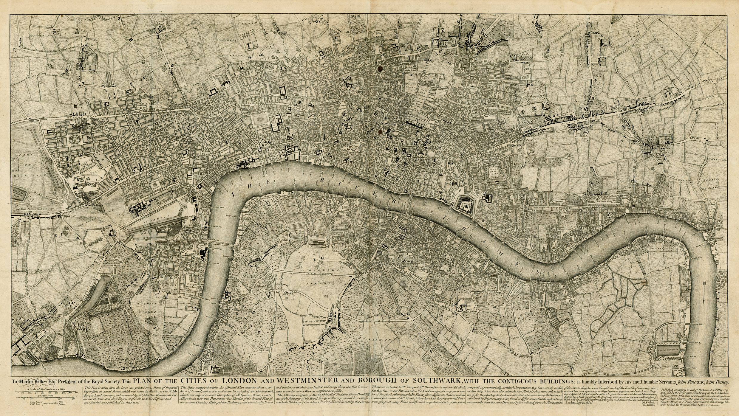
| 31 | 1746: LONDON state 1 A PLAN OF / the CITIES of / LONDON and WESTMINSTER, / and BOROUGH of / SOUTHWARK; / with the / CONTIGUOUS BUILDINGS; / From an actual SURVEY, taken by JOHN ROCQUE, / Land-Surveyor and Engraved by JOHN PINE. / BLUEMANTLE Pursuivant at Arms, and Chief / Engraver of Seals, &c. / To HIS MAJESTY. / [double rule] / This Work was begun in March / 1737 and Published in October / 1746, according to Act of Parlia- / ment, by Iohn PINE at the / Golden Head against Burling- / ton House, Piccadilly, and IOHN / TINNEY at the Golden Lion Fleet / Street LONDON. Where they / are to be sold. [sheet D3, 5e & E3, 1e] To the R.t Honourable S.r Rich.d Hoare Kn.t / LORD MAYOR, and Alderman of the Ward of Farringdon without &c / To the R.t Worshipful the Court of Aldermen of the city of London, viz.t / [list of Aldermen in 2 columns] / This Plan (in Gratitude for y.e Assistance received from them in / the Execution of it) is most humbly Inscribed by / their most obed.t humb. Servants, John Pine, & J. Tinney. [sheet G3: 3e] | [scale] ‘A Scale of 1320 Feet, making one quarter of a Mile or two Furlongs’ – ‘1300’ (166mm) / ‘A Scale of Paris Toises, making 1200 French or 1278 1/2 English Feet’ – ‘1200’ (161mm) IB:: 2044 x 3895 Howgego, London 96 (1); as the map was not published by Rocque, later states are omitted here, although described by Howgego. |
| 32 | [1746] LONDON key map A contracted Scetch of the PLAN of LONDON &c. printed on 24 Sheets of Imperial Paper, to shew the General Appearance of the Whole; for the Use of those who bind it in a Book, and for the better comprehending the Divisions mentioned in the Index. [1a, ob -5a, ob] Published in October 1746 by John Pine and John Tinney. [1e, ob] | [scale not given] 359 x 674 W: 374 x 674 PM: – x – |
| 33 | 1746: LYONS state 1 PLAN DE LION / Levé par le S.r C: SERAUCOURT / Verifié et Orienté par le R.P. GREGOIRE / de LION. [1a, olb] R. Parr sculp. [5e, orb] TO / PHILIP FUHR Esq.r / this Plan of LION / is humbly Inscrib’d by his most hum.ble Serv.t / J: Rocque. / 1746. [5a, orb] [Insets] ‘Troncons Sciez / des deux Colonnes / antiques de marbre / Granite d’Egypte, qui // flanquoient le Temple / dedié a Rome et á Au= / guste.’ [scale] ‘Echelle de dix pieds de Roy’ [no graduations, 10 units] (22mm) 30 x 112 [1b, olb] ‘FACADE DE LA SALE DU CONCER.T / du Dessein du S.r De Côtte P.r Archi= / tecte du Roy.’ 68 x 55 [1b, olb] ‘PORTAIL DE L’EGLISE DES / IACOBINS, du Dessein du Sieur / I. le Pautre, en 1674.’ 70 x 56 [1b, olb] PORTAIL DE L’EGLISE DE L’HOTEL DIEU, / du Dessein du S.r Mim= / erel, Architecte et Sculp / =teur.’ 78 x 62 [1c, olb] Monument Antique que l’on / apelloit le Tombeau des deux / Amans, démoli en 1707.’ 78 x 49 [1c, olb] ‘PORTAIL DE L’EGLISE / DES CARMELITES / du Dessein du Sr Dorbay / Architecte, en 1682.’ 83 x 46 [1d, olb] ‘PORTAIL DE L’EGLISE CA= / THEDRALE DE S. JEAN DE LYON / Achevé sous le Roy Louis XI.’ 83 x 64 [1d, orb] ‘Elevation d’un des cotez du même Hôtel de Ville.’ 77 x 144 [1e, olb] ‘VUE DE LA PLACE ROYAL DE LOUIS LE GRAND, / une des Grands Edifices, du Dessein de M.r De Cotte, P.r Architecte du Roy.’ 70 x 143 [2e, ob – 3e, ob] ‘Premier Face de l’Hotel de Ville / sur la Place des Terreaux, du des= / sein de sew S.r Simon Maupin / Architecte et Voyer de Ville.’ 70 x 64 [3e, ob] ‘PRINCIPALE FACE, sur la place des Terreaux, DU / MONASTERE ROYAL DES BÉNÉDICTINES DE S.T PIERRE, / du Dessein du S.t De la Valsiniere, Gentilhomme d’Avignon.’ 69 x 116 [4e, ob] ‘Ruins du Theátre antique des Romains, / dans le Couvent des Minimes.’ 48 x 119 [5a, orb] ‘Plan et Elevation d’une / Conserve d’Eau, Antique des / Romains, dans l’Enciente / des Vrsulines de S.t Just.’ 66 x 48 [5b, orb] ‘PORTAIL D’ENTRÉE DE L’HOTEL DIEU, / du dessin du S.r Delamonce.’ 66 x 68 [5b, orb] ‘PORTAIL COM[M]ENCÉ DE L’ / EGLISE COLLÉGIALE DE S. NIZIER, / du Dessein de Philibert Delorme / Natif de Lyon, Sur-Intendant / des Bâtimens et P.r Archite= / te du Roy Francois Premier.’ 92 x 60 [5c, orb] ‘PORTAIL DE L’ÉGLISE / COLLÉGIALE DE S.T JUST, / du Dessein du S.t Delamonce / Architecte.’ 91 x 55 [5c, orb] ‘PARTIE DU FAUBOURG DE LA CROIX ROUSSE’ [plan] 26 x 118 [5d, orb] ‘Elévation d’un des cotéz du Monastére Royal des Benedictines / de S.t Pierre, du dessein du S.r de la Valsiniere.’ 53 x 117 [5d, orb] ‘AQUEDUCS ANTIQUES DES ROMAINS, / au dehors de la Porté de S. Irenée.’ 58 x 117 [5d] ‘ELÉVATION ET PLAN DU GRENIER DE L’ABONDANCE / du Dessein du S.r de Cotte P.r Architecte du Roy.’ 52 x 118 [5e, orb] | [scale] ‘Echelle de Toise’ – ‘200’ (60mm) / ‘Scale of Brit: Feet’ – ‘1500’ (68mm) / ‘Scale of 1/4 of a Mile’ [no graduations) (61mm) [1a] 473 x 449 B: 473 x 683 PM: 484 x 692 |
| 34 | 1746: LYONS state 2 PLAN DE LION / Levé par le S.r C: SERAUCOURT / Verifié et Orienté par le R.P. GREGOIRE / de LION. [1a, olb] R. Parr sculp. [5e, orb] TO / PHILIP FUHR Esq.r / this Plan of LION / is humbly Inscrib’d by his most hum.ble Serv.t / J: Rocque. / 1746. [5a, orb] Publish’d according to Act of Parliament. [1e, olb] [Insets] ‘Troncons Sciez / des deux Colonnes / antiques de marbre / Granite d’Egypte, qui // flanquoient le Temple / dedié a Rome et á Au= / guste.’ [scale] ‘Echelle de dix pieds de Roy’ [no graduations, 10 units] (22mm) 30 x 112 [1b, olb] ‘FACADE DE LA SALE DU CONCER.T / du Dessein du S.r De Côtte P.r Archi= / tecte du Roy.’ 68 x 55 [1b, olb] ‘PORTAIL DE L’EGLISE DES / IACOBINS, du Dessein du Sieur / I. le Pautre, en 1674.’ 70 x 56 [1b, olb] PORTAIL DE L’EGLISE DE L’HOTEL DIEU, / du Dessein du S.r Mim= / erel, Architecte et Sculp / =teur.’ 78 x 62 [1c, olb] Monument Antique que l’on / apelloit le Tombeau des deux / Amans, démoli en 1707.’ 78 x 49 [1c, olb] ‘PORTAIL DE L’EGLISE / DES CARMELITES / du Dessein du Sr Dorbay / Architecte, en 1682.’ 83 x 46 [1d, olb] ‘PORTAIL DE L’EGLISE CA= / THEDRALE DE S. JEAN DE LYON / Achevé sous le Roy Louis XI.’ 83 x 64 [1d, orb] ‘Elevation d’un des cotez du même Hôtel de Ville.’ 77 x 144 [1e, olb] ‘VUE DE LA PLACE ROYAL DE LOUIS LE GRAND, / une des Grands Edifices, du Dessein de M.r De Cotte, P.r Architecte du Roy.’ 70 x 143 [2e, ob – 3e, ob] ‘Premier Face de l’Hotel de Ville / sur la Place des Terreaux, du des= / sein de sew S.r Simon Maupin / Architecte et Voyer de Ville.’ 70 x 64 [3e, ob] ‘PRINCIPALE FACE, sur la place des Terreaux, DU / MONASTERE ROYAL DES BÉNÉDICTINES DE S.T PIERRE, / du Dessein du S.t De la Valsiniere, Gentilhomme d’Avignon.’ 69 x 116 [4e, ob] ‘Ruins du Theátre antique des Romains, / dans le Couvent des Minimes.’ 48 x 119 [5a, orb] ‘Plan et Elevation d’une / Conserve d’Eau, Antique des / Romains, dans l’Enciente / des Vrsulines de S.t Just.’ 66 x 48 [5b, orb] ‘PORTAIL D’ENTRÉE DE L’HOTEL DIEU, / du dessin du S.r Delamonce.’ 66 x 68 [5b, orb] ‘PORTAIL COM[M]ENCÉ DE L’ / EGLISE COLLÉGIALE DE S. NIZIER, / du Dessein de Philibert Delorme / Natif de Lyon, Sur-Intendant / des Bâtimens et P.r Archite= / te du Roy Francois Premier.’ 92 x 60 [5c, orb] ‘PORTAIL DE L’ÉGLISE / COLLÉGIALE DE S.T JUST, / du Dessein du S.t Delamonce / Architecte.’ 91 x 55 [5c, orb] ‘PARTIE DU FAUBOURG DE LA CROIX ROUSSE’ [plan] 26 x 118 [5d, orb] ‘Elévation d’un des cotéz du Monastére Royal des Benedictines / de S.t Pierre, du dessein du S.r de la Valsiniere.’ 53 x 117 [5d, orb] ‘AQUEDUCS ANTIQUES DES ROMAINS, / au dehors de la Porté de S. Irenée.’ 58 x 117 [5d] ‘ELÉVATION ET PLAN DU GRENIER DE L’ABONDANCE / du Dessein du S.r de Cotte P.r Architecte du Roy.’ 52 x 118 [5e, orb] | [scale] ‘Echelle de Toise’ – ‘200’ (60mm) / ‘Scale of Brit: Feet’ – ‘1500’ (68mm) / ‘Scale of 1/4 of a Mile’ [no graduations) (61mm) [1a] 476 x 456 B: 476 x 690 PM: 488 x 701 State 2: with the addition of the imprint in the lower left corner. As the example seen was a lighter impression, this sequence has been assumed. There is no apparent change in the plan. |
| 35 | 1746: SHREWSBURY [Untitled Plan Of Shrewsbury] To the Right Honourable / William Baron of Hedon, / VISCOUNT PULTENEY of WRINGTON / and EARL of BATH. / This PLAN of SHREWSBURY / is most humbly inscrib’d by his Lordship’s / most humble & devoted Servant / J. Rocque. [1b] R. Parr sculp. [1e] Published by J. Rocque according to an Act of Parliament 1746. [2e, ob] [Insets] ‘THE MARKET HOUSE’ 100 x 170 [4c-5c] ‘THE FREE SCHOOL’ 88 x 155 [4d-5d] ‘THE CASTLE’ 107 x 233 [4e-5e] | [scale] ‘Scale of Feet’ – [100] – [0] ‘1000’ (1000: 93mm) [1e, ob] ‘Scale of ¼ of a Mile’ (127mm) [3e, ob] 438 x 630 PM: 455 x 643 |
| 36 | 1746: WILTON state 1 An Exact PLAN / OF THE / Gardens and Park at Wilton / The SEAT of / HENRY Earl of PEMBROKE / Together with the TOWN & also some / Views of the House and Buildings in y.e Garden. / Survey’d and Drawn by J. Rocque. [5d] To the Right Honourable / Henry Earl of Pembroke / and Montgomery; / Baron Herbert of Caerdiff, / Ross of Kendal, &c. &c. / This Plan is most hum[bly] Inscrib’d by his Lordships / Dutifull Serv.t J. Rocque. [1e] R. White sc. [5e, ob] Publish’d according to Act of Parliament, 1746. [3e] [Insets] ”The East View of the great Bridge’ 125 x 225 [1a-2a] ‘The South and east View of the House’ 115 x 181 [1b] ‘The Arcade’ 100 x 180 [1c] ‘View of the great Gate and the Porters Lodge’ 107 x 180 [1d] ‘The North View of the great Bridge.’ 109 x 179 [4a-5a] ‘Plan of the / first Storey’ 101 x 112 [5b] ‘Plan of the / second Storey’ 104 x 115 [5c] | [scale] ‘Scale of Quarter of a Mile’ [no graduations, no numbers] (162mm) / ‘Of Chains’ – [1] – [0] – ’17’ (17: 139mm) / ‘Of Perches’ – [100] – [0] – ’60’ (60: 123mm) / ‘Of Feet’ – [100] – [0] – ’60’ (60: 122mm) / ‘Of Yards’ – [100] – [0] – ‘300’ (300: 111mm) [3d] 600 x 751 W: 605 x 751 PM: 616 x 768 |
| 37 | 1746: WILTON state 2 [1746 ?] An Exact PLAN / OF THE / Gardens and Park at Wilton / The SEAT of / HENRY Earl of PEMBROKE / Together with the TOWN & also some / Views of the House and Buildings in y.e Garden. / Survey’d and Drawn by J. Rocque. [5d] To the Right Honourable / Henry Earl of Pembroke / and Montgomery; / Baron Herbert of Caerdiff, / Ross of Kendal, &c. &c. / This Plan is most hum[bly] Inscrib’d by his Lordships / Dutifull Serv.t J. Rocque. [1e] R. White sc. [5e, ob] Publish’d according to Act of Parliament, 1746. [3e] [Insets] ”The East View of the great Bridge’ 125 x 225 [1a-2a] ‘The South and east View of the House’ 115 x 181 [1b] ‘The Arcade’ 100 x 180 [1c] ‘View of the great Gate and the Porters Lodge’ 107 x 180 [1d] ‘The North View of the great Bridge.’ 109 x 179 [4a-5a] ‘Plan of the / first Storey’ 101 x 112 [5b] ‘Plan of the / second Storey’ 104 x 115 [5c] | [scale] ‘Scale of Quarter of a Mile’ [no graduations, no numbers] (162mm) / ‘Of Chains’ – [1] – [0] – ’17’ (17: 139mm) / ‘Of Perches’ – [100] – [0] – ’60’ (60: 123mm) / ‘Of Feet’ – [100] – [0] – ’60’ (60: 122mm) / ‘Of Yards’ – [100] – [0] – ‘300’ (300: 111mm) [3d] 600 x 751 W: 605 x 751 PM: 616 x 768 State 2: a small number of changes have been made to the area around the main house; in the first state, in the ‘Kitchen’ the lower building has a wall extending upwards towards ‘Kitchen’; the second state has a building added, making a ‘L’ shape [3d]; a horse with rider, and a horse and trap have been engraved in the road below and to the right of this building [3d]. In the first state, between ‘The House’ and the wood to its right was a single line of dashes, this has now been added to, to make the outline of a building with a curved porch front. Within the building is a hatched square. To the left of the ‘Kitchen’, in the first state was a double line path, between the two upper lines of trees. In the second it appears to have been replaced by a hedge (?), extending around the top of the garden, and the upper line of trees deleted. In the first state there were three lines of trees along the upper boundary, now there are only two. |
| 38 | 1747: LONDON: title-page A New and Accurate SURVEY of the / CITIES of London and Westminster, / THE / BOROUGH of Southwark, / WITH / The Country about it for nineteen Miles in / Length and thirteeen in Depth, / In which is Contain’d an exact Description of St. James’s, Kensington, Richmond, and Hampton-Court PALACES, / all the Main and Cross-Roads, Lanes and Paths, Bye-Ways, Walls, Pales, Hedges, Hills, Vallies, Rivers, Bridges, / Ferries, Brooks, Springs, Ponds, Woods, / Heaths, Commons, Parks, Avenues, Churches, Houses, Gardens, &c. / This Map will be of general Use to all Persons who have Occasion to Travel round this Metropolis, for Business, / Health or Pleasure, and to all curious Persons at Home or Abroad. Published according to Act of Parlia- / ment / 1747; Price two Guineas in Sheets, By John Rocque, Surveyor. / Begun in 1741, and finished in 1745, and publish’d in 1746, according to Act of Parliament. / [rule] / URBIUM MAXIME INSIGNIUM / LONDINI ET WESTMONASTERII, / NEC NON / MUNICIPII SUDOVERCENCIS, / Regionumque ad decem quasi Milliaria circumjacentium Delineatio Ichnographica Anno 1741, incohata / 1745, absoluta. A Johanne Rocque, Topographo. / [rule] / CARTE TOPOGRAPHIQUE / Des Villes de Londres, Westminster, / ET / Bourg de Southwark, et de leurs Environs / Contenant L’Espace de dixneuf Miles, en longeur et de treize en largeur dans la quelle sont / compris les PALAIS de St. James’s, de Kensington, D’Hampton-Court, tous les Chemins, / Sentiers, Riviers, Ruisseaux, Bacs, Ponts, Sources, Etangs, Collines, Bois, Bruyeres Com- / munes, Pares, Avenües, Eglises, Maisons, Jardins, &c. Levee tres Exactement sur les Lieux, / et Publiee selon un Acte de Parlement, en 1747. Par Jean Rocque. / [engraving ‘S Wale in.’ ‘Truchy sc’] / LONDON: / Sold by the Proprietor John Rocque, next Door to the Duke of Grafton’s Head, In Hyde Park-Road; where may be had the following / Plans, the House and Gardens of the Earl of Pembroke, the Cities of Bristol, Exeter, West-Chester, and its Castle with the intended additional / Fortifications, likewise the Cities of Lyons, Geneva, and several other remarkable Places beyond Sea, &c. | This title-page was issued to accompany bound sets of Rocque’s large-scale map of the environs of London, see no. 26 above. |
| 39 | 1747: LONDON: title-page An Exact SURVEY of the CITIES of London and Westminster, THE Borough of Southwark, WITH The Country near ten Miles round, Begun in 1741, and finished in 1745, and publish’d in 1746 … By JOHN ROCQUE Land-Surveyor: Engrav’d by RICHARD PARR, and Printed by W. PRATT. | This title-page was issued to accompany bound sets of Rocque’s large-scale map of the environs of London, see no. 26 above. |
| 40 | 1748: LONDON: title-page A New and Accurate / SURVEY / Of the CITIES of / LONDON and WESTMINSTER, / THE / BOROUGH of SOUTHWARK, / WITH / The COUNTRY about it for nineteen Miles in Length, / and thirteeen in Depth. / In which is Contain’d an exact Description of St. JAMES’S. KENSINGTON, RICHMOND and HAMP- / TON-COURT PALACES all the Main and Cross-Roads, Lanes and Paths, Bye-Ways, / Walls, Pales, Hedges, Hills, Vallies, Rivers, Bridges, Ferries, Brooks, Springs, Ponds, Woods, / Heaths, Commons, Parks, Avenues, Churches, Houses, Gardens, &c. This MAP will be of ge- / neral Use to all Persons who have Occasion to travel round this Metropolis, for Business, Health or / Pleasure, and to all curious Persons at Home or Abroad. Publish’d, according to Act of Parliament / 1748, in sixteen Sheets, Price two Guineas. / By JOHN ROCQUE, Surveyor. Begun in 1741, and publish’d in 1746 and 1748, According to Act of Parliament. / [woodblock design] / URBIUM MAXIME INSIGNIUM / LONDINI ET WESTMONASTERII / NEC NON / MUNICIPII SUDOVERCENCIS, / Regionumque ad decem quasi Milliaria circumjacentium, Delineatio Ichnographia Anno 1741, incohata 1745, absoluta. / A JOHANNE ROCQUE, TOPOGRAPHO. / [woodblock design] / CARTE TOPOGRAPHIQUE / Des Villes de Londres, Westminster, / ET / Bourg de Southwark, et de leurs Environs / Contenant L’Espace de dixneuf Miles, en longuer et de treize en largeur dans la quelle sont compris les / PALAIS de St. JAMES’S, de KENSINGTON, de RICHMOND, de HAMPTON-COURT, tous les Chemins, Sentiers, Riviers, Ruisseaux, Bacs, / Ponts, Sources, Etangs, Collines, Bois, Bruyeres Communes, Parcs, Avenües, Eglises, Maisons, Jardins, &c. Levée tres Exactement sur les / Lieux, et Publiée selon un Acte de Parlement, en 1748. Par JEAN ROCQUE. / [engraving ‘S Wale in.’ ‘Truchy sc’] / LONDON: / Sold by the Proprietor JOHN ROCQUE, next Door to the Duke of Grafton’s Head, In Hide-Park Road; whre may be had the following PLANS, / all Survey’d by the said J. ROCQUE, viz. The House and Gardens of the Right Hon . the Earl of PEMBROKE; the House and Gardens of the / Right Hon. the Earl of BURLINGTON, at Chiswick; RICHMOND Garden; KENSINGTON Garden; a SURVEY of the City of LONDON, on 24 / Sheets; the Cities of BRISTOL, EXETER, WEST-CHESTER, and its Castle, with the intended additional Fortifications; likewise the Cities of / LYONS, GENEVA, and several other remarkable Places beyond Sea, &c. / PRINTED by W. EDWARDS, at the GLOBE, Without NEWGATE. M,DCC,XLVIII. | This title-page was issued to accompany bound sets of Rocque’s large-scale map of the environs of London, see no. 26 above. |
| 41 | 1748: LONDON A MAP of LONDON and the adjacent Country 10 Miles Round, as Survey’d / and Publish’d In 16 Sheets, by John Rocque Land Surveyor, reduc’d into one Sheet. / [vertical rule] CARTE de LONDRES &c. et de ses environs reduitte en une feuille aulieu des 16 / feuilles ci devant Publiées par Jean Rocque 1748. [1a, ob – 5a, ob] R. Parr Sculp. [5e, ob] To the most High Puissant & Noble Prince IOHN Duke of MONTAGUE &c. Grand Master of the most Honourable Order of the Bath, Master General of the Ordnance, / Master of the Great Wardrobe, & Knight of the most Noble Order of the Garter, &c. &c. This Plan is most humbly Inscrib’d by his Graces most Devoted & Obed.t humble Servant / John Rocque. [1e, ob – 5e, ob] Publish’d according to Act of Parliament 1748. [3e, ob] | [scale] – ‘4 Miles’ (129mm) [2a, ob] 440 x 627 W: 500 x 633 PM: 510 x – |
| 42 | 1748: PARIS A PLAN OF PARIS AND THE ADJACENT COUNTRY / IN WHICH IS CONTAIND A DESCRIPTION OF THE VILLAGES, GREAT ROADS & OTHERS, VALLEYS, WOODS, VINYARDS, PLOWD & PASTURE LANDS. / SURVEY’D BY MONS.R ROUSSEL CAP.T INGINEER &C. TO THE MOST CHRISTIAN KING. / This PLAN has been reduced to the same scale as that of LONDON and the Country round SURVEYD, and Published in 16 Sheets by M.r JOHN ROCQUE 1748. [1a, ob – 3a, ob] PLAN DE PARIS ET DE SES FAUXBOURGS AVEC SES ENVIRONS, / OU SE TROUVE LE DETAIL DES VILLAGES, CHATEAUX, GRANDS CHEMINS ET AUTRES, DES HAUTEURS, BOIS, VIGNES, CHAMPS ET PREZ, / LEVÉ PAR MON.R ROUSSEL CAP.NE INGENIEUR DU ROY, CHE.ER DE S. LOUIS. / Ce PLAN a été Reduit Sur la meme Echelle de Celui de LONDRES et de ses Environs, en 16 Feuilles LEVÉ PAR le S.r ROCQUE. 1748. [3a, ob – 5a, ob] R. Benning sculp. [5e, ob] To his most Christian MAJESTY, / this Plan is most humbly inscribed by / his mst obedient and most humble servant / John Rocque. [2e, ob] Dedié au ROY, / par son t res humble & / tres obiessant Serviteur / Jean Rocque. [4e, ob] | [scale] ‘Scale of Chains’ – [10- [0] – ’70’ (70: 112mm) / ‘Scale of one Mile’ – ‘8’ (130mm) / ‘Scale of Perches’ – ‘200’ (80mm) / ‘Scale of Feet’ – [1000] – [0] – ‘5000’ (5000: 122mm) / ‘Scale of Yards’ – 2000′ (146mm) [1e, ob – 2e, ob] ‘Demie Lieue Parisienne’ – ‘1000 Toises’ – [100] – [0] – ‘1000 Toises’ (156mm) / Quart de Lieue de 20 au degré’ [no graduations, no numerals] (110mm) IB: 871 x 1299 B (w): 1005 x 1391 W: 1060 x 1396 7 sheets of varying sizes; |
| 43 | 1749: BERLIN PLAN DE LA VILLE / DE BERLIN / CAPITALE DE L’ELECTORAT DE BRANDEBOURG ET / LA RESIDENCE ORDINAIRE DU ROI DE PRUSSE / Réduit trés exactement d’aprés le plan en 4 Feuilles Levé / et Déssiné par ordre et Privilege privatif du Roi sous la / Direction de M. Le Feld Maréchal COMTE DE SCHMETTAU / Approuvé par L’Académie Royale des Sciences. / Ce Plan est reduit a l’Echelle du Plan de Paris Publié en 1749. / Par M. L’Abbé de la Grive L’Un et l’autre se Vendent / A LONDRES / Chez Jean Rocque Geodesiste, demeurant dans le Hide Parck road. / 1749. / Publish’d according to Act of Parliament. [2e] Gravé par Durand. Bourgoin le jeune Scripsit. [5e, ob] A Paris chez R.I. Julien a l’Hôtel de Soubise, Avec Privilege du Roy. On trouve chez la même l’Original en 4 feuilles don’t le Prix est de 18.#, et celui d’une feuille gravé en elevation en 1737. Par les Heritiers de Homann, Geographes de S.M. Imper. A Nuremberg. [1e, ob – 4e, ob] | [key] ‘EXPLICATION / A-H [in German] // EXPLICATION / [French equivalent].’ [key to Roads, Palaces, Hospitals etc] [1a, olb – 1e, olb & 5a, orb – 5e, orb] [scale] ‘Echelle de 200 Perches du Rhin’ – ‘200’ (85mm) / ‘Echelle de 400 Toises de France’ – ‘400’ (88m) [3e] [note]N.B. L’Auteur se propose de donner sur la meme Echelle les plans / des / principales Villes de l’Europe, si cet ouvrage peut meriter l’Aprobation du Public. [3e] IB: 510 x 554 B: 516 x 722 PM: 528 x 737 |
| 44 | 1749: LONDON state 1 [Untitled Plan Of London] ‘To Martin Folkes Esq.r President Of The Royal Society: This PLAN OF THE CITIES OF LONDON AND WESTMINSTER AND THE BOROUGH OF SOUTHWARK, WITH THE CONTIGUOUS BUILDINGS; is humbly Inscribed by his most humble Servants John Pine And John Tinney.’ ‘Isaac Basire } Engraved The { Plan / R.W. Seale } { Letters. [1a, ob – 1e, ob] Published according to Act of Parliament 20.th May 1749 / and Sold by the Proprietors John Pine at the Golden Head / in King Street near S.t Ann’s Church, Soho and John Tinney / Print & Map Seller at the Golden Lion in Fleet Street, / Where may likewise may be had the Original PlAn before mentioned. [1e, ob – 5e, ob] | [scale] ‘A Scale of 880 Yard or 1/2 a Mile’ – ‘880’ (77mm) / ‘400 Paris Toises’ – ‘400’ (73mm) [1e, ob] 461 x 912 W: 499 x 912 PM: – x – |
| 45 | 1749: LONDON state 2 1759 [Untitled Plan Of London] ‘To Martin Folkes Esq.r President Of The Royal Society: This PLAN OF THE CITIES OF LONDON AND WESTMINSTER AND THE BOROUGH OF SOUTHWARK, WITH THE CONTIGUOUS BUILDINGS; is humbly Inscribed by his most humble Servants John Pine And John Tinney.’ ‘Isaac Basire } Engraved The { Plan / R.W. Seale } { Letters. [1a, ob – 1e, ob] Published … 20.th May 1759 And Sold By The Proprietors John Ryall At The Golden Lion in Fleet Street, John Bowles & Son At The Black Horse In Cornhill, And Thomas Bowles Next The Chapter House … | State 2: with the revised imprint. |
| 46 | 1749: LONDON state 3 1763 [Untitled Plan Of London] ‘To Martin Folkes Esq.r President Of The Royal Society: This PLAN OF THE CITIES OF LONDON AND WESTMINSTER AND THE BOROUGH OF SOUTHWARK, WITH THE CONTIGUOUS BUILDINGS; is humbly Inscribed by his most humble Servants John Pine And John Tinney.’ ‘Isaac Basire } Engraved The { Plan / R.W. Seale } { Letters. [1a, ob – 1e, ob] Published … 20.th May 1763 … Sold By The Proprietors John Bowles In Cornhill, Carington Bowles In St. Paul’s Church Yard, Robert Sayer In Fleet Street, And Thomas Jefferys At The Corner Of St. Martins Lane In The Strand. | State 3: with the imprint again re-engraved. |
| 47 | 1749: PARIS state 1 A Plan of PARIS &c. This SURVEY has been reduced to the same SCALE as that of LONDON & the / Country round it Survey’d and Publish’d in 16 Sheets, by John Rocque Land Surveyor, 1749, next the Rummer Charing Cross. / [double rule] / Plan de PARIS &c. Ce PLAN a été reduit sur la meme ECHELLE de celui de LONDRES et de ses Environs / en 16 Feuilles levé par Jean Rocque, a Charing Cross. [1a, ob – 5a, ob] R. Benning sculpt. [??, 5e, ob] | [scale] ‘Scale of 1 Mile’ – ‘8’ (126mm) ‘Scale of Feet’ ‘1000’ – ‘5000’ – [7000] [but actually 0-6000] (6000: 144mm) ‘Demie Lieue Parisienne’ – ‘1000 Toises’ (169mm) [1e, ob – 4e, ob] 285 x 407 W: 422 x 659 PM: 435 x 680 State 1: hypothetical state, assumed from state 2, with the engraver’s name in the lower right corner. |
| 48 | 1749: PARIS state 2 1749 A Plan of PARIS &c. This SURVEY has been reduced to the same SCALE as that of LONDON & the / Country round it Survey’d and Publish’d in 16 Sheets, by John Rocque Land Surveyor, 1749, next the Rummer Charing Cross. / [double rule] / Plan de PARIS &c. Ce PLAN a été reduit sur la meme ECHELLE de celui de LONDRES et de ses Environs / en 16 Feuilles levé par Jean Rocque, a Charing Cross. [1a, ob – 5a, ob] | [scale] ‘Scale of 1 Mile’ – ‘8’ (126mm) ‘Scale of Feet’ ‘1000’ – ‘5000’ – [7000] [but actually 0-6000] (6000: 144mm) ‘Demie Lieue Parisienne’ – ‘1000 Toises’ (169mm) [1e, ob – 4e, ob] 285 x 407 W: 422 x 659 PM: 435 x 680 State 2: the engraver’s name has been partially covered by adding a second thicker engraved border around the map, outside the original border. |
| 49 | 1749: PARIS state 3 1754 A Plan of PARIS &c. This SURVEY has been reduced to the same SCALE as that of LONDON & the / Country round it Survey’d and Publish’d in 16 Sheets, by John Rocque Land Surveyor, 1754, in the Strand. / [double rule] / Plan de PARIS &c. Ce PLAN a été reduit sur la meme ECHELLE de celui de LONDRES et de ses Environs / en 16 Feuilles levé par Jean Rocque, a Charing Cross,Chorographe de S.A.R. Monseig.r le PRINCE de GALLE. [1a, ob – 5a, ob] | [scale] ‘Scale of 1 Mile’ – ‘8’ (126mm) ‘Scale of Feet’ ‘1000’ – ‘5000’ – [7000] [but actually 0-6000] (6000: 144mm) ‘Demie Lieue Parisienne’ – ‘1000 Toises’ (169mm) [1e, ob – 4e, ob] 285 x 407 W: 422 x 659 PM: 435 x 680 State 3: the title has been re-engraved to change Rocque’s address, and insert his royal title in the French title. The engraver’s name has been almost completely obliterated, partly by again widening the engraved border, and by erasing the top and tails of the lettering protruding outside the border. A small number of additions have been made in the map, for example the statute of Louis XV and the ‘Pont / tour- / nant’ in the place at the west end of the Jardin de Tuilieries [2d]; heavy lines have been engraved for the building fronts in the eastern part of the ‘FAUB. S.T HONORE’ [2b], principally along the road leading up to ‘LA VILLE / EVECQUE’, and around the garden above the place with the statue of Louis XV; the ‘Ecole / MILITAIRE’ has been inserted between ‘CHATEAU / DE GRENELLE’ and ‘HOTEL ROYALE / DES INVALIDES’ [2c] with formal gardens extending to the Seine. The gardens on either side of the gardens of the ‘HOTEL ROYALE / DES INVALIDES’ (between the buildings and the Seine) have been re-engraved, with heavy black line borders; similar heavy borders have been added along several roads in the east of the map: ”Rue de Paul’ [4b] ‘Rue des Fointaines du Roy’ [4b], ‘Rue du Mesnil’ [4b], ‘Rue de Chemin’ [4c] and ‘Rue de la Raquette’ [4c], and to the roads west of ‘Hopital / General’ [4d]. |
| 50 | 1750: BRISTOL state 1 A SURVEY of the CITY and SUBURBS of BRISTOL / Survey’d by John Rocque LAND SURVEYOR / at Charing Cross. 1750. / [vertical rule] / PLAN de la VILLE et FAUBOURGS de BRISTOL / Levé par Jean Rocque. / a Charing Cross à Londres 1750. [1a, ob – 3a, ob & 3a, ob – 5a, ob] Publish’d According to Act of Parliament. [3e, ob] [Insets] ‘A VIEW of REDCLIFT CHURCH.’ [1a, ob] 84 x 126 ‘A VIEW of the GREAT CHAIN’ [1b, ob] 85 x 126 ‘The ELEVATION of the Exchange of BRISTOL / as it fronts North to the PERISTYLE of that Structure / Together with the SECTION of the Building on each Side / the PERISTYLE.’ [1c, ob] 84 x 126 ‘The ELEVATION of the EXCHANGE of BRISTOL / as it fronts South to the General Market.’ [1d, ob] 84 x 127 ‘A VIEW of the COLLEGE and ROPE WALK.’ [1e, ob] 83 x 127 ‘A VIEW of CLIFTON and BRANDON HILLS.’ [5a, ob] 84 x 125 ‘A VIEW of the HIGH CROSS and CATHEDRAL CHURCH.’ [5b, ob] 90 x 125 ‘The ELEVATION of the EXCHANGE of BRISTOL / as it fronts North to Corn Street. ‘ [5c, ob] 85 x 126 ‘The ELEVATION of the EXCHANGE of BRISTOL / as it fronts South to the PERISTYLE of that Structure / Together with the SECTION of the Building on each side the / PERISTYLE.’ [5d, ob] 85 x 125 ‘A VIEW of S.T VINCENTS WELL from M.r Warrens House.’ 86 x 125 [5e, ob] | [scale] ‘Scale of Feet’ – [100] – [0] – 1000 (1000: 62mm) [2e, ob] ‘4 Furlongs or 1/2 a Mile’ – ‘4’ (157mm) [3e, ob] ‘Echelle de 300 Toises’ – ‘300’ (115mm) [4e, ob] 484 x 449 B: 499 x 708 W: 511 x 708 PM: 520 x 728 |
| 51 | 1750: BRISTOL state 2 1759 A NEW PLAN of the CITY and SUBURBS of BRISTOL by J. Rocque / sold by J. Palmer, BOOKSELLER in Bristol 1759 [1a, ob – 3a, ob & 3a, ob – 5a, ob] Rich: Benning Sculp: [5e, ob] Publish’d according to Act of Parliament and Sold by John Palmer in Wine Street, 1759. [3e, ob] [Insets] ‘A VIEW of REDCLIFT CHURCH. / on the South side with part of the Church Yard’ 84 x 126 [1a, ob] ‘A VIEW of the GREAT CHAIN and SLIP / at the Lower end of Princess Street.’ 85 x 126 [1b, ob] ‘The ELEVATION of the Exchange of BRISTOL / as it fronts North to the PERISTYLE of that Structure / Together with the SECTION of the Building on each Side / the PERISTYLE, of that Structure / together with the SECTION of the Building on each Side / the PERISTYLE.’ 84 x 126 [1c, ob] ‘The ELEVATION of the EXCHANGE of BRISTOL / as it fronts South to the General Market.’ 84 x 127 [1d, ob] ‘CATHEDRAL or the / VIEW of the COLLEGE and ROPE WALK. / from the Opposite South side of the River Avon’ 83 x 127 [1e, ob] A VIEW of CLIFTON and BRANDON HILLS / from the South side of the River Avon. [key] } A. Brandon Hill / } B. Clifton hill.’ 84 x 125 [5a, ob] ‘A VIEW of the HIGH CROSS and CATHEDRAL CHURCH. / from the North side of College Green.’ 90 x 125 [5b, ob] ‘The ELEVATION of the EXCHANGE of BRISTOL / as it fronts North to Corn Street.’ 85 x 126 [5c, ob] ‘The ELEVATION of the EXCHANGE of BRISTOL / as it fronts South to the PERISTYLE of that Structure / Together with the SECTION of the Building on each side the / PERISTYLE.’ 85 x 125 [5d, ob] ‘A VIEW of S.T VINCENTS WELL from M.r Warrens House the Opposite south Side of the River Avon / [key] A: S.t Vincents Rock B: the Hot Wells C: M.r Warrens House.’ 86 x 125 [5e, ob] | [scale] ‘Scale of Feet’ – [100] – [0] – 1000 (1000: 62mm) [2e, ob] ‘4 Furlongs or 1/2 a Mile’ – ‘4’ (157mm) [3e, ob] ‘Echelle de 300 Toises’ – ‘300’ (115mm) [4e, ob] 484 x 449 B: 498 x 708 W: – x 708 PM: – x – State 2: the title has been re-engraved, with coats of arms inserted at either end; the engraver’s signature has been inserted, and the publisher’s impint revised. Additions have been made to some of the inset titles. There are no obvious signs of additions in the map. |
| 52 | [1750]: BUCKINGHAMSHIRE [Untitled map of part of Buckinghamshire: north to south: ‘IVER HEATH’ – ‘WINDSOR’; west to East: ‘Eaton’ – ‘Longford’] [headed] A SPECIMEN. [3a, ob] [text below] PROPOSALS / for publishing by subscription by / JOHN ROCQUE / Land Surveyor. / An Actual Survey of the Counties of / OXFORD, BUCKS AND BERKSHIRE, / in four Sheets on a Scale of one Inch to a Mile exactly describing the Boundaries of / each County with the True Position of all the / Cities, Towns, Villages, Farm-Houses, Mills, the Main and Cross-Roads, By-Ways, Hills, Vallies, Rivers, / Brooks, Ponds, Bridges, Woods, Heaths, Parks, Seats of the Nobility and Gentry, / and all that can be desired in such a particular Survey. / … | B: 105 x 135 |
| 53 | 1750: CHEBUCKTO HARBOUR CARTE du HAVRE de CHIBUCKTO avec le PLAN de la VILLE de HALIFAX sur la Coste de L’ACCADIA ou NOVA SCOTIA Latitude 44.o 31′ / Publiée par Hautorité par Jean Rocque, Charing Cross 1750. [1a, ob – 5a, ob] To the R.y hon.ble / the EARL of HALIFAX,/ First Lord Commissioner / of TRADE & PLANTATIONS &c. &c. / This CHART of CHIBUCKTO HARBOUR, / On the COAST of ACCADIA, or NOVA SCOTIA, / With the PLAN of the TOWN of HALIFAX; / Is most humbly inscrib’d by his Lordship’s / most Obedient Servant, John Rocque. [4a] Publish’d by Authority by John Rocque at Charing Cross 1750. [2e, ob -3e, ob] [Insets] ‘PLAN of the TOWN of HALIFAX / in NOVA SCOTIA.’ 138 x 188 [1d; 1d/e – 2d/e] [key] ‘A-I.’ [1d] [scale] ‘Scale of English Feet’ – ‘1000’ (38mm) [2e] ‘Echelle de Toises’ – ‘130’ (36mm) [2e] | [scale] ‘A Scale of One League or 3 Miles’ – [3] (173mm) 559 x 435 W: 570 x 432 PM: 577 x 454 |
| 54 | 1750: CLAREMONT state 1 A SURVEY of the House, Garden & Park of CLARE MOUNT, / One of the Seats of his Grace the Duke of Newcastle. / Survey’d & Published according to Act of Parliament by J. Rocque at Charing Cross. 1750. / [vertical rule] / Plan des Jardins & Parc de CLARE MOUNT, une des Maisons / de Plaisance du Duc de Newcastle. Levé & Publié par J. Rocque, a Charing Cross. [1a, ob – 5a, ob] A Aveline sculp. [1e, ob] | [English key] 1-6 / [vertical dotted rule] / 7-12 / [vertical dotted rule] /13- 18 [1e, ob – 2e, ob] [French key] 1-6 / [vertical dotted rule] / 7-12 / [vertical dotted rule] / 13-18 [4e, ob – 5e, ob] [scale] ‘Echelle de Toises’ – ‘200’ – [0] – ’50’ (200: 90mm) / ‘A Scale of 2 Furlongs or a 1/4 of a Mile’ – ‘2’ (95mm) / ‘A Scale of 400 Yards’ – ‘300’ – [0] – ‘100’ (65mm) / ‘A Scale of 1000 Feet’ – ‘900’ – [0] – ‘100’ (65mm) [3e, ob] [text] ‘The Area containing 303 Acres’ [2e, ob & 4e, ob] 254 x 503 W: 313 x 503 |
| 55 | 1750: CLAREMONT state 2 1821 A SURVEY of the House, Garden & Park of CLARE MOUNT, / One of the Seats of the Right Hon.ble Lord Clive. / [vertical rule] / Plan des Jardins & Parc de CLARE MOUNT, une des Maisons / de Plaisance de Mylord Clive N.o 53 Fleet Street. [1a, ob – 5a, ob] A Aveline sculp. [1e, ob] Survey’d by I. Roque. [2e, ob] Published 26.th April, 1821, by R.D HOLMES LAURIE, N.o 53, Fleet Street, London, [4e, ob] | [English key] 1-6 / [vertical dotted rule] / 7-12 / [vertical dotted rule] /13- 18 [1e, ob – 2e, ob] [French key] 1-6 / [vertical dotted rule] / 7-12 / [vertical dotted rule] / 13-18 [4e, ob – 5e, ob] [scale] ‘Echelle de Toises’ – ‘200’ – [0] – ’50’ (200: 90mm) / ‘A Scale of 2 Furlongs or a 1/4 of a Mile’ – ‘2’ (95mm) / ‘A Scale of 400 Yards’ – ‘300’ – [0] – ‘100’ (65mm) / ‘A Scale of 1000 Feet’ – ‘900’ – [0] – ‘100’ (65mm) [3e, ob] [text] ‘The Area containing 303 Acres’ [2e, ob & 4e, ob] 253 x 505 W: 314 x 505 PM: 315 x 521 State 2: the title has been re-engraved, and Laurie’s imprint added. The plan appears to be unchanged. The property was acquired by Lord Clive, the first Baron, from the Duchess of Newcastle in 1770. It is plausible therefore that the re-engraving was performed by Robert Sayer, circa 1770. Subsequently, ‘Capability’ Brown was employed to lay out the gardens and build a mansion, although the work was left incomplete on his death . |
| 56 | 1750: ROME A PLAN of ROME, Surveyed & Publish’d by M.r G.B. Nolli, this PLAN has been Reduced to / the same Scale as those of Paris & London, Survey’d & Publish’d by J. Rocque at Charing Cross. / [double vertical rule] / La TOPOGRAPHIA di ROMA da G.B. Nolli è Stato Ridotta / alla medemo Scalo di quella di Londra è Parigi Che sona Publicate da me J.R. / [double vertical rule] / PLAN de ROME levé & publié in 1748 par le s.r G.B. Nolli ce PLAN a ètè reduit sur la / meme Echelle de Ceux de Paris & de Londres levè & Publie par Jean Rocque 1750. [1, ob – 5a, ob] R. Benning sc. [1e, ob] To Sir BOUCHIER WREY, / of Tavistock in the County of Devon, / Baronet, & Member of Parliament / for Barnstable, in the s.d County, / This PLAN is Humbly inscrib’d / by his Most Obedient & / Oblig’d Servant / John Rocque. [4e] | [key] ‘INDICE / Delle Fabriche piu ragguardevoli / contenute nella Pianta / 1-44 / 45-86 / 87-107 / 108-128 / 129-149 / 130-170. [1d-e – 3e] [scale] ‘Scala di 4000 Palmi Romani D’Architatura’ – ‘4000’ (80mm) / ‘A Scale of 3000 English Feet’ (79mm) / ‘A Scale of 4 Furlongs or 1/2 a Mile’ – ‘4’ (71mm) / ‘Echelle de 500 Toises’ (85mm) [1e, ob – 5e, ob] [note] ‘The Area of the Buildings / is 938 Acres.’ [3e, ob] 430 x 533 W: 457 x 533 PM: 465 x 562 |
| 57 | 1750: YORK state 1 A / PLAN of the CITY / OF / YORK / Survey’d By / Peter Chassereau. [1b] PLAN de la Ville et foubourgs de YORK Capitale de la Comté du meme Nom levé / par le S.r P: Chassereau & Publié par J. Rocque a Charing Cross, 1750. [2a, ob – 4a, ob] Publish’d according to Act of Parliament by J. Rocque at Charing Cross 1750. [3e, ob] [Insets] ‘Archbishop Bowet.’ [1a, ob – 1b, ob] 162 x 122 ‘County HOSPITAL.’ [1c, ob] 84 x 122 ‘The City House’ [1d, ob] 91 x 122 ‘The WEST Prospect of the / CATHEDRAL CHURCH’ [1e, ob] 100 x 128 ‘A MAP of the / COUNTY of YOKR / with all the / Roman Roads’ [5a, ob] 132 x 124 ‘The Prison’ [5b, ob] 90 x 124 ‘The Assembly Rooms’ [5d, ob] 95 x 124 ‘A Section of the Assembly Room’ [1e-2e] 75 x 173 ‘Thursday Market Cross’ [4e] 72 x 58 ‘Pavement Cross’ [5e] 72 x 58 | [scale] ‘Echelle de Toises’ – ‘150’ (81mm) [2e, ob] ‘Scale of Feet’ – [100] – 50 – [0] – ‘1000’ (88mm) [4e, ob] 420 x 387 B (w): 436 x 642 PM: – x 656 |
| 58 | 1750: YORK state 2 1766 A / PLAN of the CITY / OF / YORK / Survey’d By / Peter Chassereau. With Improvements to y.e Year 1766. [1b] PLAN de la Ville et foubourgs de YORK Capitale de la Comté du meme Nom levé / par le S.r P: Chassereau & Publié par J. Rocque a Charing Cross, 1750. Avec les Augmentations jusqu’a L’An 1766. [2a, ob – 4a, ob] Publish’d according to Act of Parliament by M.A. Rocque near Old Round Court Strand & W. Tesseyman Bookseller at York Price 2.s 6.d [3d ob] [Insets] ‘Archbishop Bowet.’ [1a, ob – 1b, ob] 162 x 122 ‘County HOSPITAL.’ [1c, ob] 84 x 122 ‘The City House’ [1d, ob] 91 x 122 ‘The WEST Prospect of the / CATHEDRAL CHURCH’ [1e, ob] 100 x 128 ‘A MAP of the / COUNTY of YOKR / with all the / Roman Roads’ [5a, ob] 132 x 124 ‘The Castle or County Goal’ [5b, ob] 90 x 124 ‘The Assembly Rooms’ [5d, ob] 95 x 124 ‘A Section of the Assembly Room’ [1e-2e] 75 x 173 ‘Thursday Market Cross’ [4e] 72 x 58 ‘Pavement Cross’ [5e] 72 x 58 | [scale] ‘Echelle de Toises’ – ‘150’ (81mm) [2e, ob] ‘Scale of Feet’ – [100] – 50 – [0] – ‘1000’ (88mm) [5e, ob] 422 x 390 B (w): 437 x 645 PM: 452 x 649 State 2: with Mary-Ann Rocque’s imprint substituted, and the reference to improvements inserted in both titles. Additions within the map include: ‘The Roman Multangular / Tower’ [2b], ‘Road to Scarborough’ [4b], ‘Road to Ilworth’ [5b] ‘Road to / Hull &c.’ [5d, ob] ‘The Antcient High way when Fishergate Bar was open between Fishergate & Walmgate’ [4d] The road from Fishergate Bar is now continued through the inset view of ‘Thursday Market Cross’ and labelled ‘The Ancient Road to Selby’ [4b]. The road from Fishergate Postern is labelled ‘The Road to Selby’ [4b]. The shading along the right hand bank of ‘FOSS RIVER’ is re-worked to strengthen the lines. ‘The Distillery’ has been renamed ‘The Brewery’ [3d] ‘London Road’ and ”Road to Boroughbridge are named [5d], and ‘the North Road’ [2a] ‘Pavment’ has been corrected to ‘Pavement’ [3c]. In the vignette inset, ‘The Prison’ is now ‘The Castle or County Goal’ [5b, ob] |
| 59 | [1750]: Peter MARTEL RECEUIL de PLANS de VILLES FORTIFIÈE, / Desienné par Mons.r Pierre Martel Ingenieur. & Publiée par I. Rocque; / 1750. / TWENTY PLANS &c. / of the Most Remarkable / FORTIFIED TOWNS and CITIES / in the / LOW= COUNTRYS, FRANCE & GERMANY / Designd for the Use of Students in Fortification &c. / By Peter Martel Engineer. / Publish’d by I. Rocque Surveyor at Charing Cross. | Contains 20 fortification plans, as listed on the title-page. This writer has only seen a photocopy of the title-page, and never an example of the book. |
| 60 | 1751: LONDON ENVIRONS title-page A NEW AND ACCURATE / SURVEY / Of the CITIES of / LONDON and WESTMINSTER, / THE / BOROUGH of SOUTHWARK, / WITH / The COUNTRY about it for nineteen Miles in Length, and / thirteeen in Depth. / In which is Contain’d an exact Description of St. JAMES’S. KENSINGTON, RICH- / MOND and HAMPTON-COURT PALACES all the Main and Cross-Roads, Lanes / and Paths, Bye-ways, Walls, Pales, Hedges, Hills, Vallies, Rivers, Bridges, Fer- / ries, Brooks, Ponds, Woods, Heaths, Commons, Parks, Avenues, Churches, / Houses, Gardens, &c. This MAP will be of general use to all Persons who have Occasion to travel round this Metropolis, for Business, Health or Pleasure, and / to all curious Persons at Home or Abroad. Publish’d, according to Act of Parlia- / ment 1751, in sixteen Sheets, price two Guineas. / By JOHN ROCQUE Topographer to His Royal Highness the Prince of Wales. / [engraving ‘S Wale in.’ ‘Truchy sc’] / URBIUM MAXIME INSIGNIUM / LONDINI ET WESTMONASTERII / NEC NON / MUNICIPII SUDOVERCENCIS, / Regionumque ad decem quasi Milliaria circumjacentium, Delineatio Ichnographia Anno 1751, / A JOHANNE ROCQUE, Serenissimo Frederico Walliæ Principi Topographus. / [woodblock design] / CARTE TOPOGRAPHIQUE / Des Villes de Londres, Westminster, / ET / Bourg de Southwark et de leurs Environs / Contenant L’Espace de dixneuf Miles, en longueur et de treize en largeur dans la quelle sont compris les PALAIS de St. JAMES’S, / de KENSINGTON, de RICHMOND, de HAMPTON-COURT, tous les Chemins, Sentiers, Riviers, Ruisseaux, Bacs, Ponts, Sources, / Etangs, Collines, Bois, Bruyeres Communes, Parcs. Avenües, Eglises, Maisons, Jardins, &c. Levée tres Exactement sur les Lieux, / et publiée selon un Acte de Parlement, en 1751. Par IEAN ROCQUE Topographe de S.A.R. le Prince de Galles. / [woodblock design] / LONDON: Sold by the Proprietor JOHN ROCQUE next the Barr, in Southampton-Street, Covent-Garden. / Printed by H. Lewis at the Golden Ball, in Durham-Yard. | This title-page was issued to accompany bound sets of Rocque’s large-scale map of the environs of London, see no. 26 above. |
| 61 | 1751: MADRAS A Plan / of MADRAS and / FORT S.T GEORGE, / Taken by the FRENCH Commanded by / Monsieur Matré de la Bourdonnais / On September the 21.st 1746. / Publish’d by John Rocque Chorographer to the / Late and Present Prince of Wales 1751. [1a] Plan / de MADRAS et du / FORT S.t GEORGES, / pres par les FRANCOIS, Commandes par / M.r Matré de la Bourdonnais. / le 21 Septembre 1746. / Publié par I. Rocque Chorographe de S: A.R. Monsei.r / le Prince de Galles 1751. [1b] R. Benning Sculp: [1e, ob] Publish’d according to Act of Parliament 1751 The Corner of Buckingham Street in the Strand. [3e, ob] | [key] ‘References. / 1-35. [in English] 1-35 [in French].’ [5a, orb – 5e, orb] [scale] ‘Echelle de 300 Toises’ – ‘300’ (in reverse) (75mm) [2e, ob] ‘Scale of 1/2 a Mile’ – [1/2] (in reverse) [3e, ob] ‘Scale of Feet’ – ‘2000’ [4e, ob] [only a facsimile seen] |
| 62 | 1751: NISMES PLAN DE LA VILLE DE NISME ANCIENNE ET MODERNE. [2e, ob – 4e, ob, but see note] Jean Rocque Topographe de S.A.R. le Prince de Gales Delin. 1751. [1e, ob] | [no key] [scale] – ‘500 Toises’ (222mm) [2e, ob – 4e, ob] 383 x 522 W: 402 x 522 On the example seen, the title had been cut from the paper and pasted outside the lower border, so this may not be the correct position. |
| 63 | 1752: CONSTANTINOPLE CONSTANTINOPLE, / or / STAMBOL. [3a] L’Empereur Sculpsit. [5e] Publish’d accor:g to Act of Parl.t / by J. Rocque in the Strand. [3e, ob] | [key] 1-13 / 14-27 / [27 cont.] -28-37 / 38-41 [in English] [1e, ob – 3e, ob] 1-7 / 8-19 / 20-31 / 32-41. [in French] [4e, ob – 5e, ob] [scale] ‘SCALES ECHELLES. / Four British Miles Quatre Milles Britanniques’ – 4′ (84mm) / ‘4000 Toises or two Leagues 4000 Toises ou 2 lieues Parisiennes’ – ‘4000’ – (102mm) / ‘800 British Yards 800 Verges Brittaniques’ – ‘8000’ (90mm) [3e, ob] 301 x 435 W: 356 x 435 PM: – x 453 |
| 64 | 1752: CONSTANTINOPLE: SERAGLIO THE SERAGLIO & GARDENS / of the GRAND SEIGNOR. / [vertical rule] / SERRAIL & JARDINS / du GRAND SEIGNEUR. [3a] L’Empereur Sculpsit. [5e, ob] Publish’d according to Act of Parliament 1752. / by J. Rocque Chorographer to their Royal / Highnesses the late and present Prince of / Wales. Near Round Court in the Strand. [3e, ob] | [key] ‘REFERENCES. / 1-55.’ [1a, olb – 5a, olb] ‘RENVOIS. / 1-55.’ [5a, orb – 5e, orb] [scale] ‘2000 British Feet 2000 Pieds Brittaniques’ – ‘2000’ (122mm) / ‘300 French Toises 300 Toises Francaises’ – ‘300’ (116mm) [3e] 290 x 255 B: 296 x 405 W: 300 x 405 PM: 309 x 418 |
| 65 | 1752: SHROPSHIRE CARTE TOPOGRAPHIQUE / de la Comté de / SALOP ou SHROPSHIRE / Dediée A S.A.R. MONSEIGNEUR / LE PRINCE DE GALLES / Par son trés humble et trés obéissant / Serviteur J. Rocque son Topographe. / a Londres chez l’Auteur dans le / Strand. Par Acte du / Parlement, 1752. [TR: 5c] To His Royal Highness / GEORGE / PRINCE of WALES &c. &c. / This ACTUAL SURVEY of / the County of SALOP is most humbly / Inscrib’d / By His most Dutiful, / and / Most Obedient Servant, / JOHN ROCQUE. [TR: 5b] Publish’d according to Act of Parl.t / By In.o Rocque in the Strand. Chorogro- / -pher to his R.H. the Prince of Wales. 1752. [TR: 5d] [Insets] ‘The Parish of Hales-owen belonging to the County of Salop / is detach’d from the Said County Eleven Miles, Whereon an / Actual Survey has not been made, but we have follow’d and / improved upon the old Maps in our Description of it / Aveley near Bridgenorth being the nearest place to it in Shropshire. [TL: 1d] | [scale] ‘A Scale of Statute Miles’ – ‘6’ [BR: 4d] ‘Echelle de 4000 Toises ou de deux Liëu.e.s Parisiennes de 25 au Dégré’ – ‘4000 Toises’ (113mm) [BL: 4c] [text] ‘EXPLANATION / [description of the county in English] / EXPLICATION. / [description of the county in French] [5d-e] [Dictionary of English names with French equivalents] [4d] TL: 602 x 510 w: 610 x 520 PM: 632 x – TR: 606 x 512 w: 611 x 520 PM: 625 x 533 BL: 610 x 510 w: 614 x 513 PM: 628 x – BR: 613 x 512 w: 616 x 521 PM: 630 x – |
| 66 | QUARTERMASTER’S MAP CARTE de L’ANGLETERRE et d’une Partie d’ECOSSE Gravée par le / Celebre HOLLAR / Cette CARTE a eté Reduite d’aprés les Provinces de M.R SAXTON Par ordre / d’OLIVER CROMWELLS Pour l’Usage de Ses Armées, ce qui fait qu’elle est / Réputée pour être la Meilleure de l’Isle: Toutes celles qui ont eté publieés depuis n’en / Sont que des Copies. elle est connuë Sous le nom de QUARTIER MASTERS MAP. ou CARTE des QUARTIERS MAITRE’S; les Planches ont etë dans l’oubly pendant plusieurs années par le peu de connoissance de Celuy qui le Possedoit. elles ont etè acquises par le S.R J. ROCQUE Chorographe de S.A.R. / Monseigneur le Prince de GALLES dans le Strand A LONDRES 1753 / le Prix est d’une demy-Guinèe ou 12# [sheet 5: 4e] | Six sheets: 1: 384 x 507 2: 391 x 519 3: 388 x 517 4: 384 x 499 5: 410 x 561, widest: 410 x 651; 6: 277 x – Late state of the map first etched by Wenceslas Hollar in 1644, and published by Thomas Jenner for use during the English Civil War. A number of successive states are known, includng the insertion of roads. By the time the map was re-printed by Rocque it was only of antiquarian interest. |
| 67 | [1752 ca. ?]: KENSINGTON PALACE state 1 A Plan of the Palace Gardens / and TOWN of KENSINGTON Publish’d according / to Act of Parliament by John Rocque in the Strand. [2e, ob] Plan du Palais Jardins et Bourg / de KENSINGTON, Situé à Deux Mile de LONDRES / Par Jean Rocque. Topographe de S.A.R. M.gr le Prince de Galles. [4e, ob] Deharme Sculp. [5e, ob] | [key] ‘1-8’ [in English] [1e, ob] ‘9-16 [in English] / [double vertical rule] 1-7 [in French].’ [3e, ob] ‘8-15’ [in French] [5e, ob] [scale] ‘A Scale of Feet’ – ‘1000’ (64mm) [5e, ob] ‘Echelle de Toisses’ – ‘200’ (82mm) [5e, ob] 277 x 481 |
| 68 | [1752 ca. ?]: KENSINGTON PALACE state 2 [1770 ca.] A Plan of the Palace Gardens / and TOWN of KENSINGTON Publish’d according / to Act of Parliament by John Rocque in the Strand. [2e, ob] Plan du Palais Jardins et Bourg / de KENSINGTON, Situé à Deux Mile de LONDRES / Par Jean Rocque. Topographe de S.A.R. M.gr le Prince de Galles. [4e, ob] Deharme Sculp. [5e, ob] London, Printed for Rob.t Sayer N.o 53 in Fleet Street. [3e, ob] | [key] ‘1-8’ [in English] [1e, ob] ‘9-16 [in English] / [double vertical rule] 1-7 [in French].’ [3e, ob] ‘8-15’ [in French] [5e, ob] [scale] ‘A Scale of Feet’ – ‘1000’ (64mm) [5e, ob] ‘Echelle de Toisses’ – ‘200’ (82mm) [5e, ob] 275 x 485 W: 316 x 485 PM: 324 x 505 State 2: with the addition of the imprint of Robert Sayer |
| 69 | 1753: MINORCA A New and Accurate SURVEY of the / ISLAND of MINORCA, / a Perticuler Plan of the Harbour of Mahon and its / Fortifications, with a Map of the Mediterranean Sea, / shewing the Situation od that Island and those of / Majorca and Yvica, the Ports of Barcelona, Alicant, / Cartagena, Malaga, Gibraltar, Cadiz, Lisbon, Oporto, / &c. on the European Coast; and those of Tangier, Ceuta, Tetuan, Oran, Algier &c. on that of Barbary, with Prospects / of the Town of Mahon and S.t Philip’s Castle, taken on the / Spot and lately brought from thence. / Drawn and / Engrav’d by / Capt.n Lempriere / Engineer. [4c] NOUVEL ARPENTAGE DE L’ISLE DE MINORQUE, / avec un Plan particulier de Port-Mahon / par M. Lempriere Direceteur du Bureau du Genie; / Publie & augmenté d’un Plan particulier de / la Bataille d’Almanza, par J. Rocque Chorographe / de S.A.R. M.gr le Prince de Galles, en 1753. [4d] [Insets] ‘A MAP of Part of the / MEDITERRANEAN SEA.’ [scale] ‘Scale of Statute Miles’ – ‘100’ / ‘Echelle de Lieues de 25 au d.’ Inset: ‘BATAILLE D’ALMANZA / gagnée par / les Espagnols & Francais / contre les / Anglais / & Portugaise / le 25 Avril 1709. [2b; 1a/b – 3a/b] [Untitled Map Of ‘HARBOUR OF MAHON’.] [key] ‘REFERENCES. / A-I, K-M / N-U, W-Z.’ [scale] ‘A Scale of 5000 Feet’ – ‘5’[000] [3a/b – 5a/b] ‘North Prospect of MAHON.’ 1d/e – 2d/e] ‘North Prospect of S.t PHILIPS CASTLE’ [4d/e – 5d/e] | ‘Scale for the ISLAND of MINORCA.’ – ’10 Miles’ [3e] |
| 70 | [1753 ca.]: THE SMALL BRITISH ATLAS The Small / British Atlas: / Being a new Set of Maps of all the / Counties in England and Wales; / to which is added a general Nap, with Tables / of Length, Breadth, Area, Cities, Bo- / roughs and Parishes in each County, Like- / wise a Parliamentary Map of England, / with Tables of the Produce of the Land- / Tax. A Scheme of the Proportion the several Counties paid to the three Shilling / Aid, / 1699, compared with the Number of Members they send to Parliament. / Publish’d according to Act of Parliament, / by John Rocque, Chorographer to His / Royal Highness the Prince of Wales, near Old Round Court in the Strand. | For a description of this county atlas, and of other editions, see Donald Hodson ‘County Atlases of the British Isles’ vol. II (Tewin Press, Hertfordshire, 1989) from whence the title is transcribed. |
| 71 | 1754: LONDON state 1 A PLAN of LONDON on the same scale as that of PARIS: In Order to ascertain the Difference of the Extent of these two Rivals, / the Abbe de la Grive’s plan of Paris, & that of London by J. Rocque have been divided into equal Squares where London Contains 39, and / Paris but 29, so that the Superfice of London to that of Paris as 39 to 29 or as 5455 Acres to 4028. London therefore exceeds Paris, by / 1427 Acres, the former being 8 1/2 square Miles & Paris only 6 1/3. by J. Rocque Chorographer to His Royal Highness the PRINCE of WALES, in the Strand, London 1754. / [vertical triple rule] / PLAN de LONDRES, &c. sur la même Echelle que Celui de PARIS, afin de constater la Difference en Grandeur de ces deux Rivals / on a devisé le Plan de Paris par l’Abbe de la Grive, et, Celui de Londre par J. Rocque, par desquarré donc Londres en Contient 39 & / Paris 29 Chaque quarré etant de 168440 Toises en Superficie, ce qui donne 7339 Arpens pour la surface de Londres, et 5416 pour celle / de Paris le surplus pour Londres et donc de 1923 Arpens. par J. Rocque Chorographe de S.A.R. Monseigneur le Prince de Galles a Londres 1754. [1a, ob – 5a, ob] R. Parr sculp. [5e, ob] To the most High Puissant & Noble Prince IOHN Duke of MONTAGUE &c. Grand Master of the most Honourable Order of the Bath, Master General of the Ordnance. / Master of the Great Wardrobe, & Knight of the most Noble Order of the Garter, &c. &c. This Plan is most humbly Inscrib’d by his Graces most devoted & Obed.t humble Servant. / John Rocque. [1e, ob – 5e, ob] Publish’d according to Act of Parliament. [3e, ob] | [scale] ‘A Scale of 5000 Yards’ – ‘5000’ (93mm) / ‘A Scale of 4 Miles 69 1/2 14 Poles to a Degree’ – ‘4’ (131mm) [2a, ob] ‘Echelle de 2 Lieues 25 au Degre’ – ‘2’ (180mm) / ”Echelle de 3000 Toises’ – ‘3000’ (119mm) [4a, ob] 439 x 627 W: 501 x 667 PM: 505 x 677 Howgego, London, 101.(1); |
| 72 | 1754: LONDON state 2 [ca. 1754] A PLAN of LONDON on the same scale as that of PARIS: In Order to ascertain the Difference of the Extent of these two Rivals, / the Abbe de la Grive’s plan of Paris, & that of London by J. Rocque have been divided into equal Squares where London Contains 39, and / Paris but 29, so that the Superfice of London to that of Paris as 39 to 29 or as 5455 Acres to 4028. London therefore exceeds Paris, by / 1427 Acres, the former being 8 1/2 square Miles & Paris only 6 1/3. by J. Rocque Chorographer to His Royal Highness the PRINCE of WALES, in the Strand, London 1754. / [vertical triple rule] / PLAN de LONDRES, &c. sur la même Echelle que Celui de PARIS, afin de constater la Difference en Grandeur de ces deux Rivals / on a devisé le Plan de Paris par l’Abbe de la Grive, et, Celui de Londre par J. Rocque, par desquarré donc Londres en Contient 39 & / Paris 29 Chaque quarré etant de 168440 Toises en Superficie, ce qui donne 7339 Arpens pour la surface de Londres, et 5416 pour celle / de Paris le surplus pour Londres et donc de 1923 Arpens. par J. Rocque Chorographe de S.A.R. Monseigneur le Prince de Galles a Londres 1754. [1a, ob – 5a, ob] R. Parr sculp. [5e, ob] To the most High Puissant & Noble Prince IOHN Duke of MONTAGUE &c. Grand Master of the most Honourable Order of the Bath, Master General of the Ordnance. / Master of the Great Wardrobe, & Knight of the most Noble Order of the Garter, &c. &c. This Plan is most humbly Inscrib’d by his Graces most devoted & Obed.t humble Servant. / John Rocque. [1e, ob – 5e, ob] Publish’d according to Act of Parliament. [3e, ob] | State 2: ‘New Road’ (which became the Marylebone Road) is marked. Howgego, London, 101.(1a); |
| 73 | 1754: LONDON state 3 1762 A PLAN of LONDON on the same scale as that of PARIS: In Order to ascertain the Difference of the Extent of these two Rivals, / the Abbe de la Grive’s plan of Paris, & that of London by J. Rocque have been divided into equal Squares where London Contains 39, and / Paris but 29, so that the Superfice of London to that of Paris as 39 to 29 or as 5455 Acres to 4028. London therefore exceeds Paris, by / 1427 Acres, the former being 8 1/2 square Miles & Paris only 6 1/3. by J. Rocque Chorographer to His MAJESTY ,in the Strand, London 1762. / [vertical triple rule] / PLAN de LONDRES, &c. sur la même Echelle que Celui de PARIS, afin de constater la Difference en Grandeur de ces deux Rivals / on a devisé le Plan de Paris par l’Abbe de la Grive, et, Celui de Londre par J. Rocque, par desquarré donc Londres en Contient 39 & / Paris 29 Chaque quarré etant de 168440 Toises en Superficie, ce qui donne 7339 Arpens pour la surface de Londres, et 5416 pour celle / de Paris le surplus pour Londres et donc de 1923 Arpens. par J. Rocque Chorographe de S.A.R. Monseigneur le Prince de Galles a Londres 1754. [1a, ob – 5a, ob] R. Parr sculp. [5e, ob] To the most High Puissant & Noble Prince IOHN Duke of MONTAGUE &c. Grand Master of the most Honourable Order of the Bath, Master General of the Ordnance. / Master of the Great Wardrobe, & Knight of the most Noble Order of the Garter, &c. &c. This Plan is most humbly Inscrib’d by his Graces most devoted & Obed.t humble Servant. / John Rocque. [1e, ob – 5e, ob] Publish’d according to Act of Parliament. [3e, ob] | State 3: Rocque is now shown as Topographer to the King, and the date in the title advanced to 1762. Howgego, London, 101, (2). |
| 74 | 1754: LONDON state 4 1764 A PLAN of LONDON on the same scale as that of PARIS: In Order to ascertain the Difference of the Extent of these two Rivals, / the Abbe de la Grive’s plan of Paris, & that of London by J. Rocque have been divided into equal Squares where London Contains 39, and / Paris but 29, so that the Superfice of London to that of Paris as 39 to 29 or as 5455 Acres to 4028. London therefore exceeds Paris, by / 1427 Acres, the former being 8 1/2 square Miles & Paris only 6 1/3. by J. Rocque Chorographer to His MAJESTY ,in the Strand, London 1762. / With New Improvement to the Year 1764. / [vertical triple rule] / PLAN de LONDRES, &c. sur la même Echelle que Celui de PARIS, afin de constater la Difference en Grandeur de ces deux Rivals / on a devisé le Plan de Paris par l’Abbe de la Grive, et, Celui de Londre par J. Rocque, par desquarré donc Londres en Contient 39 & / Paris 29 Chaque quarré etant de 168440 Toises en Superficie, ce qui donne 7339 Arpens pour la surface de Londres, et 5416 pour celle / de Paris le surplus pour Londres et donc de 1923 Arpens. par J. Rocque Chorographe de S.A.R. Monseigneur le Prince de Galles a Londres 1754. [1a, ob – 5a, ob] R. Parr sculp. [5e, ob] To the most High Puissant & Noble Prince IOHN Duke of MONTAGUE &c. Grand Master of the most Honourable Order of the Bath, Master General of the Ordnance. / Master of the Great Wardrobe, & Knight of the most Noble Order of the Garter, &c. &c. This Plan is most humbly Inscrib’d by his Graces most devoted & Obed.t humble Servant. / John Rocque. [1e, ob – 5e, ob] Publish’d according to Act of Parliament. [3e, ob] | State 4: with the date in the title advanced to 1764. |
| 75. | 1754: LONDON state 5 1766 A PLAN of LONDON on the same scale as that of PARIS: In Order to ascertain the Difference of the Extent of these two Rivals, / the Abbe de la Grive’s plan of Paris, & that of London by J. Rocque have been divided into equal Squares where London Contains 39, and / Paris but 29, so that the Superfice of London to that of Paris as 39 to 29 or as 5455 Acres to 4028. London therefore exceeds Paris, by / 1427 Acres, the former being 8 1/2 square Miles & Paris only 6 1/3. by J. Rocque Chorographer to His MAJESTY ,in the Strand, London 1762. / With New Improvements to the Year 1766. / [vertical triple rule] / PLAN de LONDRES, &c. sur la même Echelle que Celui de PARIS, afin de constater la Difference en Grandeur de ces deux Rivals / on a devisé le Plan de Paris par l’Abbe de la Grive, et, Celui de Londre par J. Rocque, par desquarré donc Londres en Contient 39 & / Paris 29 Chaque quarré etant de 168440 Toises en Superficie, ce qui donne 7339 Arpens pour la surface de Londres, et 5416 pour celle / de Paris le surplus pour Londres et donc de 1923 Arpens. par J. Rocque Chorographe de S.A.R. Monseigneur le Prince de Galles a Londres 1754. [1a, ob – 5a, ob] R. Parr sculp. [5e, ob] To the most High Puissant & Noble Prince IOHN Duke of MONTAGUE &c. Grand Master of the most Honourable Order of the Bath, Master General of the Ordnance. / Master of the Great Wardrobe, & Knight of the most Noble Order of the Garter, &c. &c. This Plan is most humbly Inscrib’d by his Graces most devoted & Obed.t humble Servant. / John Rocque. [1e, ob – 5e, ob] Publish’d according to Act of Parliament. [3e, ob] | State 5: with additions to 1766. Howgego, London, (3). |
| 76. | 1754: LONDON state 6 1769 A PLAN of LONDON on the same scale as that of PARIS: In Order to ascertain the Difference of the Extent of these two Rivals, / the Abbe de la Grive’s plan of Paris, & that of London by J. Rocque have been divided into equal Squares where London Contains 39, and / Paris but 29, so that the Superfice of London to that of Paris as 39 to 29 or as 5455 Acres to 4028. London therefore exceeds Paris, by / 1427 Acres, the former being 8 1/2 square Miles & Paris only 6 1/3. by J. Rocque Chorographer to His MAJESTY ,in the Strand, London 1762. / With New Improvements to the Year 1769. / [vertical triple rule] / PLAN de LONDRES, &c. sur la même Echelle que Celui de PARIS, afin de constater la Difference en Grandeur de ces deux Rivals / on a devisé le Plan de Paris par l’Abbe de la Grive, et, Celui de Londre par J. Rocque, par desquarré donc Londres en Contient 39 & / Paris 29 Chaque quarré etant de 168440 Toises en Superficie, ce qui donne 7339 Arpens pour la surface de Londres, et 5416 pour celle / de Paris le surplus pour Londres et donc de 1923 Arpens. par J. Rocque Chorographe de S.A.R. Monseigneur le Prince de Galles a Londres 1754. [1a, ob – 5a, ob] R. Parr sculp. [5e, ob] To the most High Puissant & Noble Prince IOHN Duke of MONTAGUE &c. Grand Master of the most Honourable Order of the Bath, Master General of the Ordnance. / Master of the Great Wardrobe, & Knight of the most Noble Order of the Garter, &c. &c. This Plan is most humbly Inscrib’d by his Graces most devoted & Obed.t humble Servant. / John Rocque. [1e, ob – 5e, ob] Printed for Robert Sayer N.o 53 in Fleet Street and Carington Bowles N.o 69 in S.t Pauls Churchyard. [3e, ob] | State 6: The imprint of Robert Sayer and Carington Bowles has been substituted, and the date in the title advanced to 1769. |
| 77. | 1754: MIDDLESEX state 1CARTE TOPOGRAPHIQUE DE LA COMTÉ DE MIDDLESEX. PAR JEAN ROCQUE TOPOGRAPHE de S.A.R. Monseigneur le Prince de GALLES. [TL: 1a, ob – 5a, ob] A TOPOGRAPHICAL MAP OF THE COUNTY OF MIDDLESEX BY JOHN ROCQUE 1754. by Act of Parliament. [TR: 1a, ob – 5a, ob] TO HER / Royal Highness the Princess Dowager / OF WALES, This ACTUAL SURVEY of MIDDLESEX, / Is most Humbly Inscrib’d, By HER HIGHNESS’S / Most Dutifull and Most Obedient Servant / JOHN ROCQUE Chorographer to their Royal / Highness’s the Late & Present Prince / of WALES, 1754. [TR: 5a] | [key] ‘References to the Parishes within the Bills of Mortality …’ [BR: 5a] ‘ [scale] ‘Statute Mile’ – ‘3’ (148mm) [TL: 3e, ob] ‘Scales / of 3 Miles’ – ‘3’ (148mm) / ‘Of Perches or Poles’ – ‘1000’ (152mm) / ‘Of Yards’ – ‘5000’ (140mm) / ‘Une lieue Commune’ – ‘1’ / ‘2000’ Toises’ – 2000′ (118mm) [BL: 2d] [text] ‘This County is 22 1/2 Miles in / Length …’ [in English and French] [5d] TL: 476 x 663 W: 492 x 671 TR: 475 x 664 W: 491 x 670 TL: 478 x 665 W: 483 x 673 BR: 473 x 677 W: 482 x 683 |
| 78. | 1754: MIDDLESEX state 2 [1776 ca.] CARTE TOPOGRAPHIQUE DE LA COMTÉ DE MIDDLESEX. PAR JEAN ROCQUE TOPOGRAPHE de S.A.R. Monseigneur le Prince de GALLES. [TL: 1a, ob – 5a, ob] A TOPOGRAPHICAL MAP OF THE COUNTY OF MIDDLESEX BY JOHN ROCQUE 1754. by Act of Parliament. [TR: 1a, ob – 5a, ob] TO HER / Royal Highness the Princess Dowager / OF WALES, This ACTUAL SURVEY of MIDDLESEX, / Is most Humbly Inscrib’d, By HER HIGHNESS’S / Most Dutifull and Most Obedient Servant / JOHN ROCQUE Chorographer to their Royal / Highness’s the Late & Present Prince / of WALES, 1754. [TR: 5a] | [text] ‘References to the Parishes within the Bills of Mortality …’ [BR: 5a] [scale] ‘Statute Mile’ – ‘3’ (148mm) [TL: 3e, ob] ‘Scales / of 3 Miles’ – ‘3’ (148mm) / ‘Of Perches or Poles’ – ‘1000’ (152mm) / ‘Of Yards’ – ‘5000’ (140mm) / ‘Une lieue Commune’ – ‘1’ / ‘2000’ Toises’ – 2000′ (118mm) [BL: 2d] [text] ‘This County is 22 1/2 Miles in / Length …’ [in English and French] [5d] State 2: in state 1 a ferry is shown at Richmond, in state 2 ‘Richmond / Bridge’ has been added [BL; 4c] In the text the number of parishes has been altered from 54 to 53, and the total, including the Parishes in the Bills of Mortality from 200 to 199, both in the English and French text [BL: 5e] ‘BRENTFORD P.’ is now named ‘EALING P.’ and ‘TWYFORD P.’ is named [4b & 5b] ‘Battersea / Bridge’ is inserted [BR: 2d] ‘THE BILLS / OF MORTALITY’ is engraved over London [3c & 3d] |
| 79. | 1754: RICHMONDAN EXACT PLAN OF THE ROYAL / Palace Gardens and Park at / RICHMOND / With SION HOUSE &c. on the Opposite Side / the River Thames. SURVEY’D & Publish’d by / John Rocque Chorographer / to his / ROYAL HIGHNESS THE PRINCE OF WALES / 1754. / [scale bar] [2e-3e] PLAN DU PALAIS / Jardins et Parc de Richmond / á 8 Miles de LONDRES / levé et Publié par Jean Rocque / Chorographe de S.A.R. Monseigneur / le PRINCE DE GALLES. / 1754 / [scale bar].[Insets] ‘MERLINS CAVE’ 80 x 100 [5a] ‘HERMITAGE’ 71 x 100 [5b] | [key] ‘REFERENCES / 1-17 / 20-37.’ [1e-2e] ‘RENVOY. / 1-19 / 20-37.’ [4e-5e] [scale] ‘Scale of 1500 Feet’ – ‘1500’ / ‘Half a Mile’ (78mm) [2e] ‘Echelle de 250 Toises’ – ‘250’ (81mm) IB: 319 x 447 B: 321 x 457 PM: 442 x 598 |
| 80. | 1754: WILTON state 1 Plan / du Chateau, Jardin et Parc de / Wilton la Terre du Comte de Pembroke / situeé dans la Comté de Wilts. / à 75 Miles de LONDRES. / Par J. Rocque / 1754. / [vertical design] / An Exact / Survey of the Beautiful & Magnificent / House Garden & Park of the Right / Hon.ble the EARL of PEMBROKE. / With the Ancient Town of Wilton / 3 Miles from Salisbury by John Rocque / Chorographer to his Royal Highness / The PRINCE of WALES. [2a-4a] J. Bennett Fecit. [4c][Insets] ‘North View of y.e Bridge’ 100 x 148 [1a/b – 2a/b] ‘Gate & Porters Lodge’ 98 x 139 [1c-1d] ‘Arcade’ 89 x 140 [1d/1e – 2d/e] ‘The East View of the Great Bridge’ 84 x 151 [4a/b – 5a/b] ‘View of y.e House’ 106 x 143 [4c – 5c] | [key] ‘REFERENCES / to the / PLANS of the FIRST STOREY.’ 120 x 110 [4d/e – 5d/e] [scale] ‘SCALES / A Quarter of a Mile’ [no graduations, no numbers] (80mm) / ‘of Feet’ – [1] – [0] – 1600′ (1600: 98mm) / ‘Echelle de 270 Toises’ [1] – [0] – 270′ (270: 110mm) M: 335 x 300 W: 340 x 555 PM: 350 x 556 |
| 81. | 1754: WILTON state 2 [1770 ca.] Plan / du Chateau, Jardin et Parc de / Wilton la Terre du Comte de Pembroke / situeé dans la Comté de Wilts. / à 75 Miles de LONDRES. / Par J. Rocque / 1754. / [vertical design] / An Exact / Survey of the Beautiful & Magnificent / House Garden & Park of the Right / Hon.ble the EARL of PEMBROKE. / With the Ancient Town of Wilton / 3 Miles from Salisbury by John Rocque / Chorographer to his Royal Highness / The PRINCE of WALES. [2a-4a] J. Bennett Fecit. [4c] Published according to Act of Parliament Price 2.s 6.d Printed for Rob.t Sayer N.o 53 in Fleet Street. [2e, ob – 4e, ob][Insets] ‘North View of y.e Bridge’ 100 x 148 [1a/b – 2a/b] ‘Gate & Porters Lodge’ 98 x 139 [1c-1d] ‘Arcade’ 89 x 140 [1d/1e – 2d/e] ‘The East View of the Great Bridge’ 84 x 151 [4a/b – 5a/b] ‘View of y.e House’ 106 x 143 [4c – 5c] | [key] ‘REFERENCES / to the / PLANS of the FIRST STOREY.’ 120 x 110 [4d/e – 5d/e] [scale] ‘SCALES / A Quarter of a Mile’ [no graduations, no numbers] (80mm) / ‘of Feet’ – [1] – [0] – 1600′ (1600: 98mm) / ‘Echelle de 270 Toises’ [1] – [0] – 270′ (270: 110mm) M: 335 x 300 W: 340 x 555 PM: 350 x 556 State 2: with Robert Sayer’s imprint inserted. |
| 82. | 1755: LIMAA Scenographic PLAN / of the CITY of the KINGS, / otherwise called / LIMA, / the Capital of the Kingdoms of / PERU, / Situated in the Lat:d of 12:o 2′ 31″ South, / & Long:d 299:o 27′ 7″ 0/3 East from the / Meridian of Teneriffe, / as it was before the late Earthquakes. / [rule] / The Area of the City and Suburb / is 2 Square Miles or 1306 Acres. [5b] PLAN de la VILLE des ROYS, ou LIMA Capitale du PEROU situées a la Latitude Meridionale de 12:o 2′ 31″ Longitude 299:o 27′ 7″ 0/3 a l’Est du Meridien de Teneriffe par Jean Rocque Chorographe de S.A.R. Mons.r le PRINCE de GALLES 1755. [2a, ob – 4a, ob] Published According to Act of Parliament by John Rocque Chorographer to his Royal Highness y.e Prince of Wales in y.e Strand 1755. [3e, ob – 4e, ob] | [key] ‘1-34 / 35-55 / 56-70.’ [1a/b – 2a] [scale] ‘Scale of 4 Furlongs or half a Mile’ – [4] (115mm) [2e, ob] ‘Echelle de 300 Toises’ – ‘[2]50’ – [300] (81mm) [4e, ob] 368 x 523 W: 377 x 523 PM: 382 x 539 |
| 81. | 1755: PALAIRET NORTH AMERICA state 1CARTE / DES POSSESSIONS / ANGLOISES & FRANÇOISES / DU CONTINENT DE / L’AMERIQUE SEPTENTRIONALE / 1755. [5d] Tho.s Kitchin Sculp.t [3e] On trouvera dans le troisiéme volume de la Nouvelle Introduction à la Géographie Moderne, que l’Auteur de l’Atlas Méthodique doit publier incessament, la description des païs, des peuples & des colonies de ce continent. Se vend à Londres chez / M.rs Nourse, Vaillant, Millar, Rocque & autres; à Amsterdam & à Berlin chez M.r Neaulme, & à la Haye chez M.r P. Gosse. [2e, ob – 4e, ob] | [key] ‘Explication. / [symbol marking French forts / colour code for the various colonial powers] [4d] [scale] ‘Echelle. / Milles d’Angleterre de 69 au Degré’ – ‘234’ (78mm) / Lieues communes de France de 25 au Degré’ – ‘125’ (78mm) / Lieues marines de France & d’Angl. De 20 au Degré’ – ‘100’ [4d] 415 x 578 PM: 443 x 601 |
| 82. | 1755: NORTH AMERICA state 2 [ca. 1756] CARTE / DES POSSESSIONS / ANGLOISES & FRANÇOISES / DU CONTINENT DE / L’AMERIQUE SEPTENTRIONALE / 1755. [5d] Tho.s Kitchin Sculp.t [3e] On trouvera dans le troisiéme volume de la Nouvelle Introduction à la Géographie Moderne, que l’Auteur de l’Atlas Méthodique doit publier incessament, la description des païs, des peuples & des colonies de ce continent. Se vend à Londres chez / M.rs Nourse, Vaillant, Millar, Rocque & autres; à Amsterdam & à Berlin chez M.r Neaulme, & à la Haye chez M.r P. Gosse. [2e, ob – 4e, ob] | [key] ‘Explication. / [symbol marking French forts / colour code for the various colonial powers] / n.b. La province de Main & la territoire de Sagadahook, sont / de la jurisdiction de Massachusets-Bay. [4d] [scale] ‘Echelle. / Milles d’Angleterre de 69 au Degré’ – ‘234’ (78mm) / Lieues communes de France de 25 au Degré’ – ‘125’ (78mm) / Lieues marines de France & d’Angl. De 20 au Degré’ – ‘100’ [4d] 413 x 576 PM: 440 x 598 State 2: the note about Maine and Sagadahook Bay has been added to the key. The boundary between the English Colonies and the area occupied by allies of England but claimed by France is now engraved on the map, extending from ‘Pensacola B.’, on the Gulf Coast, to ‘Niagara F.t’ on Lake Ontario. The boundary between South Carolina and Georgia is now engraved, extending from Savannah to Augusta and then in a horizontal line to the western border of the map. The name ‘la Fourche’ has been inserted in a fork in the upper courseof one of the tributaries of the Mississippi River, between the ‘Illinois R’ and the ‘Theakiki R’, just east of ‘F.t des Miamis’ and to the south of Lake Michigan [2c]. ‘NOUV. / MEXICO’ is named [1d] |
| 83. | 1755: NORTH AMERICA state 3 [1763] CARTE / DES POSSESSIONS / ANGLOISES & FRANÇOISES / DU CONTINENT DE / L’AMERIQUE SEPTENTRIONALE / 1755. [5d] Tho.s Kitchin Sculp.t [3e] On trouvera dans le troisiéme volume de la Nouvelle Introduction à la Géographie Moderne, que l’Auteur de l’Atlas Méthodique doit publier incessament, la description des païs, des peuples & des colonies de ce continent. Se vend à Londres chez / M.rs Nourse, Vaillant, Millar, Rocque & Sayer; à Amsterdam & à Berlin chez M.r Neaulme & Covens & Mortier, & la Haye chez M.r P. Gosse. [2e, ob – 4e, ob] | [key] ‘Explication. / [symbol marking French forts / colour code for the various colonial powers] / n.b. La province de Main & la territoire de Sagadahook, sont / de la jurisdiction de Massachusets-Bay. [4d][scale] ‘Echelle. / Milles d’Angleterre de 69 au Degré’ – ‘234’ (78mm) / Lieues communes de France de 25 au Degré’ – ‘125’ (78mm) / Lieues marines de France & d’Angl. De 20 au Degré’ – ‘100’ [4d] 413 x 576 PM: 440 x 598 State 3: described by Sellers and van Ee thus: ‘The name “I. Palairet” has been added in the map, several boundaries altered, and additional place names inserted.’ Sellers & Van Ee, 57; |
| 84. | [1756]: DUBLIN: KEY MAP state 1A Plan of the CITY of DUBLIN and its ENVIRONS on the same Scale of LONDON, PARIS & ROME, by John ROCQUE, CHOROGRAPHER TO HIS R: H: the PRINCE of WALES. / [vertical rule] / PLAN de DUBLIN et de ces ENVIRONS sur la meme Echelle de ceux de LONDRES, PARIS, et ROME par J: ROCQUE CHOROGRAPHER de S:A:R: Monseigneur le PRINCE du GALLES. [1a, ob – 5a, ob] J:J: Perret sculpsit. [5e, ob] Published according to Act of Parliament. [3e, ob] | [scale] ‘A Scale of an Irish Mile’ – ‘320 Perches’ (167mm) / ‘A Scale of Yards’ – ‘1000’ (82mm) [1e, ob – 2e, ob] ‘Echelle de Toises – ‘500’ (92mm) / ‘A Scale of an English Mile’ – ‘320 Perches’ (132mm) [4e, ob – 5e, ob] [text] This PLAN is to be follow’d by that of y.e City and Subburbs in four Sheets where every Particular will be Express’d as mention’d in the Proposal. [1b, olb – 1d, olb, to be read from the left] 502 x 713 W: 508 x 713 PM: 521 x 730 |
| 85. | [1756]: DUBLIN: KEY MAP state 2 [1760 ?] A Plan of the CITY of DUBLIN and its ENVIRONS on the same Scale of LONDON, PARIS & ROME, by John ROCQUE, CHOROGRAPHER TO HIS R: H: the PRINCE of WALES. / [vertical rule] / PLAN de DUBLIN et de ces ENVIRONS sur la meme Echelle de ceux de LONDRES, PARIS, et ROME par J: ROCQUE CHOROGRAPHER de S:A:R: Monseigneur le PRINCE du GALLES. [1a, ob – 5a, ob] J:J: Perret sculpsit. [5e, ob] Published according to Act of Parliament. [3e, ob] | [scale] ‘A Scale of an Irish Mile’ – ‘320 Perches’ (167mm) / ‘A Scale of Yards’ – ‘1000’ (82mm) [1e, ob – 2e, ob] ‘Echelle de Toises – ‘500’ (92mm) / ‘A Scale of an English Mile’ – ‘320 Perches’ (132mm) [4e, ob – 5e, ob] 503 x 700 W: 516 x 707 PM: 521 x 713 State 2: lacking the reference to the four-sheet map outside the upper left border of the map. |
| 86. | 1756: DUBLIN: state 1AN EXACT SURVEY of the CITY and SUBURBS / of DUBLIN in Which is Express’d the Ground Plot / of all PUBLICK BUILDINGS DWELLING HOUSES / WARE HOUSES Stables COURTS Yards &c. by / IOHN ROCQUE Chorographer to their / ROYAL HIGHNESSES the Late & Present Prince / of WALES. / 1756. [2a] TO / THEIR EXCELLENCIES Robert VISCOUNT JOCELYN / Lord HIGH CHANCELOR James EARL of KILDARE and / Brabazon EARL of BESSBOROUGH LORDS / Justices GENERALand GENERAL GOVERNORS of IRELAND, this / PLAN is Most Humbly inscribed by their EXCELLENCIES / most Dutiful and most Obedient humble / Servant / Iohn Rocque. [2b] Published according to Act of Parliament. [2e, ob] A. Dury sculp.t [3e] N.o 1 [1a] N.o 2 [5a] N.o 4 [1c] N.o 3 [3e][Inset] [Untitled Sketch Map Of Ireland] ib: 53 x 34 [2e] | [key] ‘REFERENCES. / [list of symbols].’ [2b] [scale] ‘A Scale of British Feet’ – ‘1000’ (137mm) / ‘Perches’ / { Irish – ’40’ (106mm) / { English – ’40’ (84mm) / Echelle de Toises’ – ‘110’ (85mm) [2e] 986 x 1410 PM: 999 x 1416 This map is known in at least 5 states, of which the “second” may reflect gradual corrections over a period, rather than one process. For this see ‘Two maps of 18th century Dublin and its surroundings by John Rocque’, introduction by J.H. Andrews (Lympne Castle, Kent: Harry Margary, 1977). |
| 87. | 1756: ST PHILIP’S CASTLE state 1A Plan of / S.T PHILIPS CASTLE, / on the Island of MINORCA; / with its Fortifications, & the Entrance / of the Harbour of Port Mahon / By Jn.o Armstrong Esq.r / Surveyor General to the Hon.ble Board of Ordnance. / [double rule] / To the Most High Puissant & Noble Prince / Charles Duke of Marlborough &c, Master Gen.l of y.e Ordnance / Knight of the most Noble Order of the Garter, &c. &c. / This Plan, is most humbly Inscribed / by his Graces most Devoted & Obed.t hum.ble Serv.t / Jn:o Rocque / 1756. [2c] | [key] ‘Explanation. / A-I, K-T, V-Z, &, a-f.’ [1d] [scale] ‘Feet’ – ‘2000’ (124mm) [3e] 662 x 455 PM: – x – |
| 88. | 1756: ST PHILIP’S CASTLE state 2 [1756 ca.] A Plan of / S.T PHILIPS CASTLE, / on the Island of MINORCA; / with its Fortifications, & the Entrance / of the Harbour of Port Mahon / By Jn.o Armstrong Esq.r / Surveyor General to the Hon.ble Board of Ordnance. / [double rule] / To the Most High Puissant & Noble Prince / Charles Duke of Marlborough &c, Master Gen.l of y.e Ordnance / Knight of the most Noble Order of the Garter, &c. &c. / This Plan, is most humbly Inscribed / by his Graces most Devoted & Obed.t hum.ble Serv.t / Jn.o Rocque / 1756. [2c] | [key] ‘Explanation. / A-I, K-T, V-Z, &, a-f.’ [1d] [scale] ‘Feet’ – ‘2000’ (124mm) [3e] [note] ‘NB This Plan shew’s all the French Batterys / which were Erected during the Siege. [3d] 662 x 455 PM: – x – State 2: a number of additions have been made, to show positions during the siege, including the reference to French siege positions. ‘R. Rockpine’ [2b] ‘B. Le Blanc’ with an unnamed battery to its left [4b], ‘B. Louis Cours’ [5c] ‘B. S.t André’ and ‘B. S.t Michelle [4b], in ‘S.t Philips / Town’], ‘B Le Pellouse’ ‘B. Le Blanc’ and ‘B. Dolsie’ [4b]. With the exception of ‘B. Rockpine’ and the unnamed battery, lines of fire have been engraved from these batteries to the fort. |
| 89. | 1757: DUBLIN HARBOURA Survey of the CITY HARBOUR BAY and ENVIRONS of DUBLIN, on the same Scale as those of LONDON, PARIS & ROME. By / John Rocque CHOROGRAPHER TO HIS Royal Highness THE PRINCE of WALES. [1a, ob -3a, ob] PLAN de la VILLE, HAVRE, BAY & ENVIRONS de DUBLIN sur la meme Echelle de ceux de LONDRES, PARIS & ROME, par Jean Rocque Chorographe / de S:A:R: MONSEIGNEUR le PRINCE des GALLES. 1757. [3a, ob – 5a, ob] J: J: Perret sculpsit [3e, ob] To his Royal Highness Prince / EDWARD / This Plan is most / humbly inscribed / By / His Most Obedient / Humble Servant / John Rocque. [1b] Published according to Act of Parliament. [2e, ob][Insets] ‘KILDARE HOUSE’ [2b] ‘G. Smith Delin. [1b] 120 x 209 [1a/b – 2a/b] ‘THE BARRACKS’ 120 x 207 [2a] THE ROYAL HOSPITAL’ 112 x 130 [2a, ob; 2a] ‘DUBLINE’ [4d] ‘Anno 1610’ [4d] ‘Dublin comme il etoit en 1610.’ [4b] ‘This PLAN is Copyed from that taken in 1610 and the / Spelling the Same as at that Time. [key] 1-18 / 19-36. [4d] 37-52, + / 53-69. [4d] 141 x 65 [4d] | [key] ‘EXPLANATION. / [list of symbols in 7 columns] [3e, ob – 4e, ob] [scale] ‘A Scale of an Irish Mile’ – ‘320 Perches’ (163mm) / ‘A Scale of Yards – ‘1000’ (81mm) [1e, ob – 2e, ob] ‘Echelle de Toises’ – [100] – [0] – ‘500’ (76mm] / ‘A Scale of an English Mile’ – ‘320 Perches’ (130mm) [2e, ob – 3e, ob] 972 x 1390 W: 1008 x 1396 |
| 90. | 1757: MIDDLESEXA Map of / the COUNTY of / MIDDLESEX / Reduced from an actual Survey in four Sheets / By John Rocque. / [rule] / Carte de la / PROVINCE / de MIDDLESEX reduite / D’apres un arpantage en quatre feuilles / Par Jean Rocque / 1757. [3a] Publish’d according to Act of Parliament by J. Rocque in the Strand. Price 2.s 6.d [2e-3e] | [scale] ‘A Scale of 6 Miles’ – ‘6’ (150mm) / ‘Scale of Perches or Poles’ – ‘2000’ (154mm) / ‘Deux lieues commune’ – ‘2 (135mm) [1e] [text] ‘This County is 22 1/2 Miles / in Length … [repeated in French] [5b] 513 x 690 PM: 518 x 701 |
| 91. | 1757: ROCHEFORTA PLAN of the City, And the Harbour of ROCHEFORT, a place remarkable for its fine docks, & surprizing Magazines for Warlike Stores where from this Important / place are continually sent supplies of all sorts for Building Men of War to Brest, L’Orient, S.t Malo’s, Toulon & several other Sea Ports in FRANCE. [1a, ob – 5a, ob] Publish’d according to Act of Parliament by E. Oakley Oct. 20. 1757. & Sold by J. Rocque near Round Court in the Strand. [2e, ob – 3e, ob][Insets] ‘A MAP of the Island of AIX.’ [scale] – ‘800 Yards’ (32mm) 78 x 101 [5a] [Untitled Chart Of The Environs of ‘Rochefort’ extending from ‘La Rochelle’ to ‘Broage’] [scale] ‘Leagues of France 25 to a Degree’ – ‘5’ (103mm) 81 x 167 [4d/e – 5d/e] | [Scale] ‘200 Fathom’ (92mm) [3e] 287 x 477 PM: 304 x 473 |
| 92. | 1757: ST. MARTINSA PLAN of the CITY of S.T MARTINS in the ISLAND of RÉ Drawn by the Kings Engineer. [2a, ob – 4a, ob] Publish’d by In.o Rocque Topographer to His Royal Highness the Prince of Wales, next Old Round Court in the Strand, according to Act of Parliam.t October 20.th 1757. [2e, ob – 4e, ob] | [scale] – ‘300 Toises’ (91mm) [4e-5e] [text] N.B. S.t Martin is a well Fortified Town / of France in the Island of Ré, three / Liegues from Rochell; which place / was besieged by the English in the / Years 1627, & 1696, but without success. [3c] 148 x 271 W: 158 x 271 |
| 93. | 1757: TRINCHINOPOLYA PLAN of the CITY / and the Country about / TRINCHINOPOLY. / with the Encampments of the / English & French Army; / that of the English Commanded by / Colonel Stringer Lawrence, in the Years 1753, & 1754. / [key] 1-4. [1d] To his Royal Highness / WILLIAM Duke of CUMBERLAND, / Captain General of his Majesty’s Forces &c. &c. / This PLAN is most humbly inscrib’d, by his most Obedient Servant / John Rocque / Chorographer to his Royal Highness / the Prince of Wales. [5d] Publish’d according to Act of Parliament Aug.st 12.th 1757, & Sold by John Rocque near Round Court in the Strand. [3e, ob] | [scale] ‘Scale of One Mile’ – ‘1’ (91mm) [1e] 590 x 735 PM: 610 x 755 |
| 94. | [1758: BRITTANY] 1758 A CHART / of part of the coast of / BRETAGNEY & NORMANDY, / From Granville to Cape Frehel. / Taken from the Neptune François. / By Jn.o Rocque 1758. [1a] Publish’d according to Act June 14.th 1758. By Jn.o Rocque near Round Court in the Strand. [3e, ob | ‘Remarks or References. / …’ [5a-b] ‘Echelle de 2 Lieüs’ – ‘2’ (46mm) [4e] 208 x 342 PM: 243 x 353 |
| 95. | 1758: EUROPE state 1CARTE GÉNÉRALE / des Postes de / L’EUROPE. / dans laquelle / on a tracé toutes les Routes, et marqué / toutes les Places ou la Poste est établie. / Par le S.r Rocque Topographe de L.A.R. / le défunt et le présent / PRINCE de GALLES. / 1758. [1a] J. Gibson Sculp.t [5e] To the Right Hon:ble / George Montague, / EARL of CARDIGAN, / Baron Brudenell, &c. &c. / This Map of the / Post-Roads of / EUROPE / is Dedicated / by his Lordships / Most Obed.t Humble Serv.t / John Rocque. [1b] Publish’d Accor.g to Act of Parliament by J. Rocque Chro= / grapher to his R.H. the Prince of Wales near Round-Court / in the Strand. [5d] | [scale] ‘Scale of English Miles 69 1/2 to a Degree’ – ’10’ – ‘0 – ‘200’ (200: 105mm) / ‘Italian 60 Miles to a Degree’ – ’10’ – ‘0’ – ‘200’ (200: 123mm) / ‘Irish 55 Miles and 71 Poles to a Degree, Plantation Measure’ – ’10’ – ‘0’ – ‘200’ (131mm) / ‘Leagues 25 to a Degree’ – ’10’ – ‘0’ – ’90’ (90: 131mm) / ”Leagues 20 to a Degree’ – ’10’ – ‘0’ – ’70’ (70: 129mm) ‘German 16 Miles to a Degree’ – ’10’ – ‘0’ – ’60’ (60: 123mm) / ‘Versts 105 to a Degree’ – ’10’ – ‘0’ – ‘400’ (141mm) [3b] 825 x 878 PM: – x – |
| 96. | 1758: EUROPE state 2 1786A GENERAL MAP / OF THE / POST ROADS / OF EUROPE, / wherein / ALL THE POST STAGES / with THEIR DISTANCES / are particularly Expressed; / BY JOHN ROCQUE, / Topographer to THE KING. [1b] CARTE GÉNÉRALE / DES POSTES / DE L’EUROPE. / Dans laquelle on a Tracé Toutes les Routes, et / Marqué Tous les Lieux ou la Poste est Establie. / PAR LE SIEUR ROCQUE / Topographe du ROI. / A LONDRES / Chez Robert Sayer, Fleet Street, as the Act Directs. May 26.th 1786. [1a] J. Gibson Sculp.t [5e] | [scale] ‘Scale of English Miles 69 1/2 to a Degree’ – ’10’ – ‘0 – ‘200’ (200: 105mm) / ‘Italian 60 Miles to a Degree’ – ’10’ – ‘0’ – ‘200’ (200: 123mm) / ‘Irish 55 Miles and 71 Poles to a Degree, Plantation Measure’ – ’10’ – ‘0’ – ‘200’ (131mm) / ‘Leagues 25 to a Degree’ – ’10’ – ‘0’ – ’90’ (90: 131mm) / ”Leagues 20 to a Degree’ – ’10’ – ‘0’ – ’70’ (70: 129mm) ‘German 16 Miles to a Degree’ – ’10’ – ‘0’ – ’60’ (60: 123mm) / ‘Versts 105 to a Degree’ – ’10’ – ‘0’ – ‘400’ (141mm) [3b] 817 x 878 PM: – x – State 2: the new English title has been engraved in place of the original dedication, and the original French title has been re-engraved. |
| 97. | 1758: GIBRALTAR state 1PLAN of the PENINSULA / and part of the ISTHMUS, / of GIBRALTAR. / Inscribed to John Portland Esq.r / by his most humble Servant / Jn.o Rocque / 1758. [5a] | |
| 98 | 1758: GIBRALTAR state 2 [1760 ca] PLAN of the PENINSULA / and part of the ISTHMUS, / of GIBRALTAR. / Inscribed to John Portland Esq.r / by his most humble Servant / Jn.o Rocque. [5a] | [1-66, 68-73, 67-69, in 16 columns] [1e, ob – 5e, ob] [scale] ‘A Scale of 700 Feet to an Inch’ – ‘2640 or half a Mile English’ – ‘3000’ Feet’ (103mm) [4e] 214 x 683 W: 234 x 683 PM: 243 x 702 State 2: with the date deleted from the title. |
| 99 | 1758: GIBRALTAR state 3 [1782] PLAN of the PENINSULA / and part of the ISTHMUS, / of GIBRALTAR. / Inscribed to John Portland Esq.r / by his most humble Servant / Jn.o Rocque. [5a] London, Printed for John Farrell, N.o 7 Pater Noster Row. [4e] | [1-66, 68-73, 67-69, in 16 columns] [1e, ob – 5e, ob] [scale] ‘A Scale of 700 Feet to an Inch’ – ‘2640 or half a Mile English’ – ‘3000’ Feet’ (103mm) [4e] 214 x 683 W: 234 x 683 PM: 243 x 702 State 3: with the imprint of John Farrell inserted. The penultimate column of the key has been re-engraved [4e, ob], relating to the large fort on the left hand border [1c]. A new trench extends in a wavy line from this fort to the battery keyed ’60’ [2c]; originally there were two batteries here, but the uppermost of the two has been replaced by an oval fortification, with two gun positions show inside. |
| 100. | 1758: KILKENNYA / SURVEY of the CITY of KILKENNY / By / John Rocque Corrographer / To His / ROYAL HIGHNESS the PRINCE of WALES. [2a] G. Byrne sculp.t [5e] To / The R.t Hon.ble WILLIAM Earl / of Besborough, Lord Ponsonby, Baron Ponsonby of / Sysonby, Governor of the County of Kilkenny, one of the Lords for Executing / the Office of Lord High Treasurer, and one of His Majesty’s / most Honourable Privy Council. This PLAN of / KILKENNY is most Humbly Inscribed by Your / Lordships Most obedient Serv.t / John Rocque. / 1758. [4e] | [scale] ‘A Scale of British Feet’ – ‘300’ (74mm) [1d] [text] ‘NB. This Plan is on the same Scale, / as those of London, Dublin, Cork, Bristol, / and Exeter, by the said Rocque. [1d] 495 x 694 |
| 101. | 1758: LONDON AFTER THE FIREA Plan for Rebuilding the CITY after the Fire, Design’d by that Great Architect S.r CHRISOPH.R WREN and approv’d of by King and PARLIAMENT / but unhappily Defeated by FACTION. [1a, ob – 5a, ob] [set in a sheet entitled] VUES / DE LA / VILLE de LONDRES / Comme il etoit devant & apres / L’INCENDIE de 1666. / AVEC / Le PLAN pour la rebatir. / Projette par ce grand ARCHITECTE le / Chevalier CHRISTOPHLE WREN, & / aprouve par le Roi & PARLEMENT; mais / malheureusement rejettè par Faction. / Publiè par JEAN ROCQUE, / Chorographe deSon Altesse / royalle le Prince de GALLES. / 1758. [5a, orb – 5e, orb] ‘A PROSPECT of the CITY of LONDON from S. MARIE OVER STEEPLE in SOUTHWARK in its flourishing Condition before the FIRE’ ‘Another PROSPECT of the above CITY taken from the Same PLACE as it Appeared after that DREADFULL FIRE in 1666’ | [key] ‘EXPLANATION to the PLAN / The shadowed part is that which escap’d the Conflagration / C. Churches M. Markets.’ [1d, olb] [scale] ‘A Scale of 1800 Feet.’ – ‘100’ – ‘0’ – ‘1800’ (54mm) [1e, olb] ‘A Scale of 200 Toises’ – ‘100’ – ‘0’ – ‘200’ (35mm) / ‘560 Yards or 1/4 of a Mile Irish’ – ’60’ – ‘0’ – ‘500’ (47mm) / ‘440 Yards of 1/4 of a Mile English’ – ’40’ – ‘0’ – ‘400’ (34mm) [5e, orb] 144 x 329 B: 348 x 519 Page: 359 x 519 |
| 102. | [1758 ca.] L’ORIENTA PLAN of the / CITY AND THE HARBOURS OF / L’ORIENT AND PORT LOUIS, / Drawn by the Kings Engineer. / Sold by John Rocque Chorographer to his Royal Highness the Prince of Wales near Old Round Court in y.e Strand. [3a] | [key] ‘a- d / [vertical rule] / e-h / [vertical rule] / i, l-n / [vertical rule] / o-r / [vertical rule] / s, t, v, x / [vertical rule] / y. z, &, 1 / [vertical rule] / 2-5.’ [1e, ob – 5e, ob] [no scale] 263 x 516 W: 284 x 516 |
| 103. | 1758: ST. MALOA PLAN of / S.T MALO’S, / Taken from Mons.r le Chevalier / de Beaurain, / Publish’d at Paris. / By Jn.o Rocque of London. / June 12.th 1758. [3b] Publish’d according to Act June 12.th 1758, by J. Rocque near Round Court in the Strand. [3e, ob – 4e, ob][Inset] ‘PLAN DE / CHERBOURG / Ville de la Basse Normandie’ [scale] ‘100 Toises’ – ‘100 (28mm) (ib): 101 x 112 [4e; 4d/e – 5d/e] | [key] ‘1-39’ [1b-1e] [scale] ‘Echelle de deux Cent Toises’ – ‘200’ (90mm) [2e] 240 x 341 |
| 104. | 1759: CORK state 1 A / SURVEY / OF THE / CITY and SUBURBS / OF / CORK / By J. Rocque / 1759. [1d] TO THE / RIGHT WORSHIPFUL THE / MAYOR ALDERMEN & / COMMON COUNCIL / of this CITY / This PLATE is Inscribed / by their most hum.ble Servant / John Rocque. [2a] Publish’d according to Act of Parliament May. [gap] 1759, by John Rocque Chorographer to His Royal Highness the Prince of Wales, near Round Court in the Strand London. Price 5 Shillings. [2e, ob – 4e, ob] | [scale] ‘A Scale of British Feet’ – [100] – [0] – ‘900’ (900: 112mm) / ‘One Furlong { Irish ) – ’40 Perches’ (101mm) { English – ’40 Perches’ (81mm) / { Toises – ‘110’ (82mm) [1e] 603 x 791 PM: 611 x 803 |
| 105. | 1759: CORK state 2 1771 A / SURVEY / OF THE / CITY and SUBURBS / OF / CORK / By J. Rocque / 1759. / With All The New / Improvements to / 1771. [1d] TO THE / RIGHT WORSHIPFUL THE / MAYOR ALDERMEN & / COMMON COUNCIL / of this CITY / This PLATE is Inscribed / by their most hum.ble Servant / John Rocque. [2a] Publish’d according to Act of Parliament May. [gap] 1759, by John Rocque Chorographer to His Royal Highness the Prince of Wales, near Round Court in the Strand London. Price 5 Shillings. [2e, ob – 4e, ob] | [scale] ‘A Scale of British Feet’ – [100] – [0] – ‘900’ (900: 112mm) / ‘One Furlong { Irish ) – ’40 Perches’ (101mm) { English – ’40 Perches’ (81mm) / { Toises – ‘110’ (82mm) [1e] 596 x 804 State 2: with the title now noting improvements to 1771. |
| 106. | 1759: CORK state 3 1773 A / SURVEY / OF THE / CITY and SUBURBS / OF / CORK / By J. Rocque / With All The New / Improvements to / 1773. [1d] TO THE / RIGHT WORSHIPFUL THE / MAYOR ALDERMEN & / COMMON COUNCIL / of this CITY / This PLATE is Inscribed / by their most hum.ble Servant / John Rocque. [2a] LONDON. Printed for ROB.T SAYER, Map and Printseller, N.o 53 in Fleet Street [2e, ob – 4e, ob] | [scale] ‘A Scale of British Feet’ – [100] – [0] – ‘900’ (900: 112mm) / ‘One Furlong { Irish ) – ’40 Perches’ (101mm) { English – ’40 Perches’ (81mm) / { Toises – ‘110’ (82mm) [1e] 601 x 794 PM: 610 x 804 State 3: with the title now noting improvements to 1773. |
| 107. | 1759: DRESDENDRESDEN on the Elbe Capital of SAXONY, Residence of the Elector of SAXONY. / KING of POLAND. / [vertical double rule] / DRESDE, sur l’Elbe Capitale de la SAXE Residence de l’Electeur de SAXE ROY de POLOGNE. / A Londres chez le S:r Rocque. 1759. 1a, ob – 5a, ob] Sold by J. Rocque Near Old Round Court in the Strand London. [3e, ob] | [key] ‘REFERENCES. / 1-50.’ [5a, orb – 5e, orb] 51-60 / [double vertical rule] / 61-69 / [double vertical rule] / 70-79 / [double vertical rule] / 80-88 / [double vertical rule] / 89-98 / [double vertical rule] / 99-107 / [double vertical rule] / 108-117 / [double vertical rule] / 118-126 / [double vertical rule] / 127-136 / [double vertical rule] / 137-146. [1e, ob – 5e, ob] [scale] ‘Scale of Pases’ – ‘1000’ (84mm) [5a, orb] [text] DRESDEN Capital of SAXONY is divided by the Elbe into Old and New Town The Bridge has 19 Arches and is 800 Paces long The Suburbs are Considerable being full of Houses the Castle is Magnificient. [1e, ob – 5e, ob] 361 x 485 B: 361 x 547 W: 443 x 547 PM: 454 x – |
| 108. | 1759: QUEBEC state 1A PLAN of / QUEBEC. / QUEBEC. / The Capital of New France or Canada in America is situatd upon the / River S.t Lawrence at 57 deg. 12.m North Latitude Longitude 5.o degrees / 30. min west from the Island of Fero its distance from the Mouth / of the River is about 270 Miles an extent Navigable for Ships of most / … [1a, olb – 1d, olb] Publish’d according to Act of Parliam. Jan. 1759 by E. Oakley & Sold by J. Rocque near Round Court in the Strand.’ [3e, ob][Inset] ‘The Port & Environs of Quebec. / as it was when attack’d by the English.’ [3a] | [key] ‘REFERENCES. / A-F [1a, olb – 1e, olb][scale] ‘Scale of 300 Yards’ – ‘300’ (74mm) [4e] 308 x 353 W: 321 x 508 |
| 109. | 1759: QUEBEC state 2 1759 A PLAN of / QUEBEC. / QUEBEC. / The Capital of New France or Canada in America is situatd upon the / River S.t Lawrence at 57 deg. 12.m North Latitude Longitude 5.o degrees / 30. min west from the Island of Fero its distance from the Mouth / of the River is about 270 Miles an extent Navigable for Ships of most / … [1a, olb – 1d, olb] Publish’d according to Act of Parliam.t Octob.r 1759 by E. Oakley & Sold by J. Rocque near Round Court in the Strand. [3e ob][Inset] ‘The Port & Environs of Quebec. / as it was when attack’d by the English.’ [3a] ‘A Draught of part of the River S. Laurence.’ [5a] | [key] ‘REFERENCES. / A-F [1a, olb – 1e, olb] [scale] ‘Scale of 300 Yards’ – ‘300’ (74mm) [5e] 308 x 351 B: 308 x 507 W: 323 x 507 PM: 327 x 519 State 2: with the month in the imprint revised to October 1759, and the second inset added: |
| 109. | 1760: ARMAGH COUNTY state 1A TOPOGRAPHICAL MAP of the County of ARMAGH, to which is Anex’d the PLANS of NEWRY and ARMAGH by Iohn Rocque. 1760. [1a, ob – 5a, ob] CARTE TOPOGRAPHIQUE de la PROVINCE D’ARMAGH ou se trouve les PLANS des VILLES D’ARMAGH et NEWRY, par I. Rocque, 1760. [TR: 1a, ob – 5a, ob] The First Sheet of an Actual SURVEY of the COUNTY of ARMAGH by John Rocque. [BL: 2a, ob – 4a, ob] THE 2.d Sheet. [BR: 2a, ob] To the most REV.D FATHER in GOD / GEORGE / LORD ARCHBISHOP OF ARMAGH / PRIMATE and METROPOLITAN of all / IRELAND / This SURVEY of the COUNTY of ARMAGH / Is humbly inscribed by His GRACES / Most obedient humble Servant / John Rocque. [BR: 2e][Insets] ‘A PLAN of the TOWN of / NEWRY / Situated in the Countys of / DOWN and ARMAGH. / [scale bar].’ [scale] ‘A Scale of British Feet’ – ‘900’ [100] – [0] – ‘900’ (900: 643mm) (ib w:) 368 x 379 [TL: 1a; 1a-c – 3a/3d] ‘A / PLAN / of the / CITY of / ARMAGH. / [rule] / REFERENCES. / A-I, K-R.’ [scale] [100] – 0] – ‘900 Feet’ (900: 72mm) 272 x 305 [TR: 5b; 3a/c – 5a/d] | [scale] ‘A Scale of Irish Miles’ – ‘3’ (148mm) / ‘A Scale of English Miles’ – ‘3’ (116mm) [BL: 4d] [text] NB: The Impossibilty of finding the true Mearings of the / BARONYS has Obliged us to have Recourse to S.r Will:m Petty’s Surveys. [BF: 5e] TL: 472 x 655 W: 478 x 655 PM: – x 664 TR: 469 x 653 W: 479 x 656 BL: 469 x 652 W: 480 x 652 BR: 469 x 651 W: 478 x 651 PM: 488 x – State 1: dedicated to George, Lord Archbishop of Armagh. |
| 110. | 1760: ARMAGH COUNTY state 2 [1770 ca. ?] A TOPOGRAPHICAL MAP of the County of ARMAGH, to which is Anex’d the PLANS of NEWRY and ARMAGH by Iohn Rocque. [TL: 1a, ob – 5a, ob] CARTE TOPOGRAPHIQUE de la PROVINCE D’ARMAGH ou se trouve les PLANS des VILLES D’ARMAGH et NEWRY, par I. Rocque, 1760. [TR: 1a, ob – 5a, ob] The First Sheet of an Actual SURVEY of the COUNTY of ARMAGH by John Rocque. [BL: 2a, ob – 4a, ob] THE 2.d Sheet. [BR: 2a, ob] To the most REV.D FATHER in GOD / RICHARD / LORD ARCHBISHOP OF ARMAGH / PRIMATE and METROPOLITAN of all / IRELAND / This SURVEY of the COUNTY of ARMAGH / Is humbly inscribed by His GRACES / Most obedient humble Servant / John Rocque. [BR: 2e] LONDON. Printed for ROB.T SAYER, Map and Printseller, N.o 53, in Fleet Street. [BR: 2e, ob]‘A PLAN of the TOWN of / NEWRY / Situated in the Countys of / DOWN and ARMAGH. / [scale bar].’ [scale] ‘A Scale of British Feet’ – ‘900’ [100] – [0] – ‘900’ (900: 643mm) (ib w:) 368 x 379 [TL: 1a; 1a-c – 3a/3d] ‘A / PLAN / of the / CITY of / ARMAGH. / [rule] / REFERENCES. / A-I, K-R.’ [scale] [100] – 0] – ‘900 Feet’ (900 : 72mm) 272 x 305 [TR: 5b; 3a/c – 5a/d] | [scale] ‘A Scale of Irish Miles’ – ‘3’ (148mm) / ‘A Scale of English Miles’ – ‘3’ (116mm) [BL: 4d] [text] NB: The Impossibilty of finding the true Mearings of the / BARONYS has Obliged us to have Recourse to S.r Will:m Petty’s Surveys. [BL: 5e] TL: 468 x 659 PM: 492 x 668 TR: 469 x 650 PM: 493 x 668 BL: 470 x 650 PM: 493 x 674 BR: 464 x 649 PM: 488 x 673 State 2: with the addition of Robert Sayer’s imprint. The dedication is now to Richard, Lord Archbishop of Armagh. |
| 111. | [1760: ARMAGH COUNTY state 3 1802 A TOPOGRAPHICAL MAP of the County of ARMAGH, to which is Anex’d the PLANS of NEWRY and ARMAGH by Iohn Rocque. [TL: 1a, ob – 5a, ob] CARTE TOPOGRAPHIQUE de la PROVINCE D’ARMAGH ou se trouve les PLANS des VILLES D’ARMAGH et NEWRY, par I. Rocque, 1760. [TR: 1a, ob – 5a, ob] The First Sheet of an Actual SURVEY of the COUNTY of ARMAGH by John Rocque. [BL: 2a, ob – 4a, ob] THE 2.d Sheet. [BR: 2a, ob] To the most REV.D FATHER in GOD / RICHARD / LORD ARCHBISHOP OF ARMAGH / PRIMATE and METROPOLITAN of all / IRELAND / This SURVEY of the COUNTY of ARMAGH / Is humbly inscribed by His GRACES / Most obedient humble Servant / John Rocque. [BR: 2e] London: Published by LAURIE & WHITTLE, 53 Fleet Street. 1802 [BR: 2e, ob] [BR: 2e, ob][Insets] ‘A PLAN of the TOWN of / NEWRY / Situated in the Countys of / DOWN and ARMAGH. / [scale bar].’ [scale] ‘A Scale of British Feet’ – [100] – [0] – ‘900’ (900: 643mm) (ib w:) 368 x 379 [TL: 1a; 1a-c – 3a/3d] ‘A / PLAN / of the / CITY of / ARMAGH. / [rule] / REFERENCES. / A-I, K-R.’ [scale] [100] – [0] – ‘900 Feet’ (900: 72mm) (ib w:) 272 x 305 [TR: 5b; 3a/c – 5a/d] | [scale] ‘A Scale of Irish Miles’ – ‘3’ (148mm) / ‘A Scale of English Miles’ – ‘3’ (116mm) [BL: 4d] NB: The Impossibilty of finding the true Mearings of the / BARONYS has Obliged us to have Recourse to S.r Will:m Petty’s Surveys. [BL: 5e] TL: 468 x 659 PM: 492 x 668 TR: 469 x 650 PM: 493 x 668 BL: 470 x 650 PM: 493 x 674 BR: 464 x 649 PM: 488 x 673 State 3: with Laurie and Whittle’s imprint substituted outside the lower border. |
| 112. | [1760 ca]: DUBLINAN ACTUAL SURVEY of the COUNTY of DUBLIN, on the same Scale, as those of MIDDLESEX, OXFORD, BERKS, & BUCKINGHAMSHIRE, by Iohn Rocque. [TL: 1a, ob – 5a, ob] CARTE TOPOGRAPHIQUE de la COMTE de DUBLIN Sur la meme Echelle de Ceux de MIDDLESEX, OXFORD, BARKS, & BUCKINGHAM. Par J. Rocque Chorographe de S.A.R. Monseigneur le Prince de [Galles] [TR: 1a, ob – 5a, ob] To The High, Puissant and most Noble Prince, / IOHN DUKE OF BEDFORD / Marquess of Tavistock and Earl of Bedford / Baron Russell of CHENIES, Baron Russell of THORNHAUGH, and / Baron Howland of STREATHAM, one of the Lords of his / Majesties Most Honourable Privy Council / Lord Lieutenant and Custos Rotulorum of the County / and Town of BEDFORD, And of the County of DEVON. & / CITY of EXETER, Major General of his Majesties Forces / Knight of the most Noble Order of the Garter / Lord Lieutenant General and General / Governor of the Kingdom of Ireland / This ACTUAL SURVEY of / the County of DUBLIN. / is humbly Inscribed By / HIS GRACES / Most Humble and / Obedient Servant / Jn.o Rocque. [TR: 4c] | [scale] ‘A Scale of three Irish Miles’ – ‘3’ (188mm) / ‘A Scale of three English Miles’ – ‘3’ (150mm) [BR: 4e] TL: B: 576 x 786 W: 592 x 786 TR: 570 x 787 W: 589 x 787 BL: 573 x 788 BR: 574 x 792 Two proof forms are recorded. The first, sent to the Duke of Bedford, is very incomplete. The map was later re-issued by Robert Sayer and Laurie and Whittle. |
| 113. | 1760: GENEVA state 1PLAN of GENEVA and the Environs. [1a, ob – 2a, ob] PLAN de GENEVE avec ses Environs. [4a, ob – 5a, ob] Publish’d According to Act of Parliament 1760. [3e, ob][Insets] ‘PLAN DE / GENEVE / Anciene.’ 101 x 94 [1a] ‘PLAN DE / GENEVE / en 1715.’ 62 x 100 [5a] ‘CARTE / du Balliage de Gexen France / et des Baillage de Ternier / et Gaillard en Savoye / avec / ce qui est de la dependance / de / GENEVE / Levè par M.r Grenier Comisaire / de la Republique.’ [scale] ‘2 Lieues de 20 au Degré’ – [8 units, no numbers] (31mm) 110 x 114 [3e] | [key] ‘REFERENCES. / 1-28.’ [1d-1e] ‘REFERENCES. / 29-55. [5d-5e] [scale] ‘1/4 of a Statue Mile’ [2 units, no numbers] (65mm) [2e, ob] ‘Pieds de France’ – ‘100’ – ‘0’ – ‘1100’ (1100: 59mm) [4e, ob] 476 x 626 W: 490 x 626 PM: 498 x – |
| 114. | 1760: GENEVA state 2 [1760 ca.] PLAN of GENEVA and the Environs. [1a, ob – 2a, ob] PLAN de GENEVE avec ses Environs. [4a, ob – 5a, ob] Publish’d According to Act of Parliament 1760. [3e, ob] To Peter Gaussen Esq.r / This PLAN is Inscrib’d by his / most humble & Oblig’d Servant / I. Rocque. [3a][Insets] ‘PLAN DE / GENEVE / Anciene.’ 101 x 94 [1a] ‘PLAN DE / GENEVE / en 1715.’ 62 x 100 [5a] ‘CARTE / du Balliage de Gexen France / et des Baillage de Ternier / et Gaillard en Savoye / avec / ce qui est de la dependance / de / GENEVE / Levè par M.r Grenier Comisaire / de la Republique.’ [scale] ‘2 Lieues de 20 au Degré’ – [8 units, no numbers] (31mm) 110 x 114 [3e] | [key] ‘REFERENCES. / 1-28.’ [1d-1e] ‘REFERENCES. / 29-55. [5d-5e] [scale] ‘1/4 of a Statue Mile’ [2 units, no numbers] (65mm) [2e, ob] ‘Pieds de France’ – ‘100’ – ‘0’ – ‘1100’ (1100: 59mm) [4e, ob] State 2: not seen, but assumed from the third state, as it would seem plausible that the dedication was added at an intermediate between the first and third states. |
| 115. | 1760: GENEVA state 3 1766 PLAN of GENEVA and the Environs. [1a, ob – 2a, ob] PLAN de GENEVE avec ses Environs. [4a, ob – 5a, ob] Publish’d According to Act of Parliament 1766. [3e, ob] To Peter Gaussen Esq.r / This PLAN is Inscrib’d by his / most humble & Oblig’d Servant / I. Rocque. [3a][Insets] ‘PLAN DE / GENEVE / Anciene.’ 101 x 94 [1a] ‘PLAN DE / GENEVE / en 1715.’ 62 x 100 [5a] ‘CARTE / du Balliage de Gexen France / et des Baillage de Ternier / et Gaillard en Savoye / avec / ce qui est de la dependance / de / GENEVE / Levè par M.r Grenier Comisaire / de la Republique.’ [scale] ‘2 Lieues de 20 au Degré’ – [8 units, no numbers] (31mm) 110 x 114 [3e] | [key] ‘REFERENCES. / 1-28.’ [1d-1e] ‘REFERENCES. / 29-55. [5d-5e] [scale] ‘1/4 of a Statue Mile’ [2 units, no numbers] (65mm) [2e, ob] ‘Pieds de France’ – ‘100’ – ‘0’ – ‘1100’ (1100: 59mm) [4e, ob] State 3: the date in the imprint has been advanced to 1766. A number of additions have been made in the map, although they could have been made either in state 2 (perhaps more plausible) or state 3. In the key is the addition ’55 Les Pompes publiques’ [5e], including ‘Fontaine de / Meme’ [2b], Additions include: ‘Moulin / Pictet’ [2b, in the Rhone], ‘Foule’ [2b, in the Rhone] ‘Moulin / a / bateau’ [2c, in the Rhone] ‘Moulins / Chandon’ [2c, in the Rhone] and ‘Moulin / Cotteau’ [2d, in the Rhone]; the ‘Rue du Coutance’ has been re-engraved, with ‘v’ shaped hatching on the upper side, and the key number 56 added in the place at the end [2b]; ‘Les Painpiniere / de la Seigneurie’ [2c] and ‘Le Teatre’ [2c] are named just above the inner line of fortifications, to the right of the southern part of the island in the Rhone. ‘Terage / de Bomb’ is noted [4b]. |
| 116. | 1760: ROUVIER SWITZERLAND state 1CARTE / DE / SUISSE / OU SONT / LES TREIZE CANTONS / LEURS ALLIÉS / ET LEURS SUJECTS / Dressée Rectifiée et Augmentée / sur les meilleurs Auteurs, sur plusieurs / Cartes Manuscrites et Observations / faites sur les Lieux / Par ABR: ROUVIER. 1760. [1a] T. Kitchin Sculp. [5e, in border] Presentée et Dediée / tres respecteusement a Son Excellence / Milord Vicomte de Ligonier / Membre de Conseil prive de sa Majesté Britannique / Chevalier de l’Ordre du Bain / Colonel du Premier Regiment des Gardes à Pied / Feld Marechal & Commandant en Chef des Armées de la / GRANDE BRETAGNE / Grand Maitre d’Artillerie &c. &c. &c. / Par son tres humble / et tres obeissant Serviteur / A. Rouvier. [1b] Publish’d by A. Rouvier 1760 According to Act of Parliament. [3e, ob][Inset] [William Tell Shooting The Apple Off His Son’s Head] [2a] | [key] ‘Explication des Marques. / [symbols, in three columns].’ [4d-5d] [scale] Echelle. / de Douze Lieues communes de Suisse don�t 24 font un Degre.’ – ’12’ (104mm) [4e] 512 x 678 PM: 530 x 697 |
| 117. | 1760: ROUVIER SWITZERLAND state 2 1760 CARTE / DE / SUISSE / OU SONT / LES TREIZE CANTONS / LEURS ALLIÉS / ET LEURS SUJECTS / Dressée Rectifiée et Augmentée / sur les meilleurs Auteurs, sur plusieurs / Cartes Manuscrites et Observations / faites sur les Lieux / Par ABR: ROUVIER. 1760. [1a] A NEW MAP of SWITZERLAND by A. ROUVIER, Revised and Improved by IOHN ROCQUE Topographer to his R.H. the Prince of Wales 1760. [2a, ob – 4a, ob] T. Kitchin Sculp. [5e, in border] Presentée et Dediée / tres respecteusement a Son Excellence / Milord Vicomte de Ligonier / Membre de Conseil prive de sa Majesté Britannique / Chevalier de l’Ordre du Bain / Colonel du Premier Regiment des Gardes à Pied / Feld Marechal & Commandant en Chef des Armées de la / GRANDE BRETAGNE / Grand Maitre d’Artillerie &c. &c. &c. / Par son tres humble / et tres obeissant Serviteur / A. Rouvier. [1b] Publish’d by I. Rocque 1760 According to Act of Parliament. Near Round Court in the Strand London. [3e, ob][Inset] [William Tell Shooting The Apple Off His Son’s Head] [2a] | [scale] ‘Echelle. / de Douze Lieues communes de Suisse don�t 24 font un Degre.’ – ’12’ (104mm) [4e] [text] ‘AVERTISSEMENT. / …’ [5a-5b] 511 x 675 PM: 534 x 696 State 2: with the second title added outside the upper border, and Rocque’s imprint substituted in the lower border. Despite his claim, there does not appear to be any additions in the map. |
| 118. | [1760] IRELAND state 1A MAPP OF THE / Kingdom of Ireland, divided into / Provinces, Counties and Baronies, Shewing / The Archbishopricks, Bishopricks, Cities, Boroughs, Market Towns, / Villages, Barracks, Mountains, Lakes, Bogs, Rivers, Bridges, / Ferries, Passes; Also the Great, the Branch, & the By Post Roads, together with the Inland Navigation &c. by J: ROCQUE / Chorographer to y.e Prince of Wales. [2a]Inset: ‘The Sea Coasts of GREAT BRITAIN and IRELAND.’ [5e] | [key] [list of symbols] [5d] ‘English Miles 69 and a half to a Degree’ – ’40’ ‘Irish Miles in proportion to the English …’ [3e] 967 x 1250 4 sheets joined State 1: hypothetical state, presumably with Rocque’s imprint. |
| 119. | [1760] IRELAND state 2 [1770 ca.] A MAPP OF THE / Kingdom of Ireland, divided into / Provinces, Counties and Baronies, Shewing / The Archbishopricks, Bishopricks, Cities, Boroughs, Market Towns, / Villages, Barracks, Mountains, Lakes, Bogs, Rivers, Bridges, / Ferries, Passes; Also the Great, the Branch, & the By Post Roads, together with the Inland Navigation &c. by J: ROCQUE / Chorographer to y.e Prince of Wales. [2a] London Printed for Rob.t Sayer opposite Fetter Lane Fleet Street. [3e]Inset: ‘The Sea Coasts of GREAT BRITAIN and IRELAND.’ [5e] | [key] [list of symbols] [5d] ‘English Miles 69 and a half to a Degree’ – ’40’ ‘Irish Miles in proportion to the English …’ [3e] 967 x 1250 4 sheets joined State 2: with Sayer’s imprint inserted. |
| 120. | [1760] IRELAND state 3 [1770 ca.] A MAPP OF THE / Kingdom of Ireland, divided into / Provinces, Counties and Baronies, Shewing / The Archbishopricks, Bishopricks, Cities, Boroughs, Market Towns, / Villages, Barracks, Mountains, Lakes, Bogs, Rivers, Bridges, / Ferries, Passes; Also the Great, the Branch, & the By Post Roads, together with the Inland Navigation &c. by J: ROCQUE / Chorographer to HIS MAJESTY. [2a] London Printed for Rob.t Sayer opposite Fetter Lane Fleet Street. [3e]Inset: ‘The Sea Coasts of GREAT BRITAIN and IRELAND.’ [5e] | [key] [list of symbols] [5d] ‘English Miles 69 and a half to a Degree’ – ’40’ ‘Irish Miles in proportion to the English …’ [3e] 967 x 1250 4 sheets joined State 3: with Rocque’s title altered. A later state has the imprint of Laurie and Whittle substituted. |
| 121. | 1761: BERKSHIRE 1761 A TOPOOGRAPHICAL MAP, OF THE COUNTY, / OF BERKS, BY JOHN ROCQUE, TOPOGRAPHER TO HIS MAJESTY, 1761. [XVIII & XVII] CARTE TOPOGRAPHIQUE DE LE COMTÉ DE BERKS, / PAR JEAN ROCQUE, TOPOGRAPHE DE SA MAJESTÉ BRITANNIQUE, 1761. [XIV & XIII] TO HIS / Sacred Majesty, / GEORGE the THIRD, / this Survey of / BERKSHIRE; / is most humbly Inscrib’d, / by his MAJESTY’S / Dutiful, Obliged, Loyal / Subject, & humble Servant, JOHN ROCQUE. // S. Wale delin. A. Walker sculp. [title cartouche] [XV] L.F. Deharme Sculp.t [III: 5e] Publish’d According to Act of Parliament by Iohn Rocque 1761. [V: 1e, ob][Inset] ‘A Plan of READING.’ [scale] ‘Scales of Yards’ – ‘800’ (67mm) ‘Of Perches’ – 150′ (66mm) [both engraved in reverse order] [text] ‘A Short Account of the Antiquity of Reading. / …’ [III: 3e] 155 x 166 [III: 1e] [Berkshire south of ‘Bacons Farm’] [V: 4d] | [scale] ‘Scales’ / ‘of Miles’ – ‘3’ (150mm) / ‘of Perches’ – ‘900’ (144mm) / ‘of Yards’ – ‘5000’ (143mm) / ‘Echelle d’une Lieue Commune de 25 au degre’ [4 graduations, no numbers] (133mm) [III: 5d] [note] An ALPHABETICAL LIST of the PARISHES, their / Length, Breadth, Circumference, & Content in ACRES. And in what Plate contained. [IX] 18 sheets, Total dimensions: 1590 x 2710 Engraving of the map commenced in 1752, but the completed map was not published until 1761. Some of the sheets are recorded in up to 4 states, making a complete description of the map complicated. see Eugene Burden ‘Printed Maps of Berkshire 1574-1900 (typescript, of which an annotated copy is held in the BL’s Map Library.) |
| 122. | 1761: BERKSHIRE: title-pageA / Topographical Survey / OF THE / COUNTY OF BERKS, / IN / EIGHTEEN SHEETS. / IN WHICH IS EXPRESSED, / His MAJESTY’s ROYAL PALACE of WINDSOR, its PARKS and / FORREST; the SEATS of the Nobility and Gentry; Towns, / Villages, Hamlets, Farms, Cottages, &c. / WITH / The Main and Cross ROADS, Bridle WAYS, PALES, HEDGES, HILLS, VALLEYS, / RIVERS, BROOKS, CANALS, PONDS, BRIDGES, FERRIES, Wind and Water MILLS, / WOODS, HEATHS, COMMONS, and GREENS, appertaining to each Parish, &c. / TO WHICH IS ADDED, / A GEOGRAPHICAL and HISTORICAL INDEX / Of all REMARKABLE PLACES in the said COUNTY; with their BEARINGS and DISTANCE to the next MARKET TOWN, or WELL-KNOWN PLACE. / The Length, Breadth, Circumference, and Content, in Acres and Square Miles, of the County, Windsor Forest, / and of each Parish. / By J. ROCQUE, Topographer to His MAJESTY. / LONDON: Printed for and Sold by the Author, near OLD ROUND-COURT, in the STRAND. / Price TWO GUINEAS and a HALF. / Printed by JAMES DIXWELL, in ST. MARTIN’s LANE, near CHARING-CROSS. / MDCCLXI. | Letterpress title, accompanying bound examples of no.118. |
| 123. | 1761: ENGLAND AND WALESENGLAND AND WALES / Drawn from the most Accurate Surveys / Containing all the / Cities, Boroughs, Market Towns & Villages; In which are included all the Improvements and Observations both / Astronomical and Geographical, / which have been made by Members / of the Royal Society, & others / Down to the present Year, / The whole corrected & improv’d / By JOHN ROCQUE / Chorographer to his Majesty. [4a] 1761 [4b]Inset: [Untitled Map Of ‘ISLES of SCILLY’ and ‘Lands End’] [note] These Isles are Drawn to the / same Scale & inserted here to / prevent the great Contraction / of the General Map.’ 56 x 139 [1d | [key] ‘EXPLANATION. / …’ [4e] ‘SCALES’ / ‘British Statute Miles 69 1/2 to a Degree’ – ’60’ (138mm) / ‘British Sea Leagues 20 to a Degree’ – ’20’ (161mm) [4b] 1152 x 980 There are several states of this map, re-issued by Robert Sayer and Laurie and Whittle. |
| 124. | [1761]: FRANCE state 1A / NEW MAP / of / FRANCE, / in which the / POST STAGES / are Exactly Express’d, with the Number / of Leagues, from place to place: / by John Rocque [1761 ??]. / N.B. a Post is two Leagues, Post and a half three / Leagues, double Post four Leagues. [1d] T. Kitchin sculp. [1e] Sold by J. Rocque Chorographer to His Royal Highness the Prince of Wales, near Old Round Court … | [scale] ‘Echelles’ / ‘Grandes Lieues de France’ – ’20’ (51mm) / ‘Milles d’Italie’ – ’60’ ((51mm) / ‘Lieues communes de France de 25 au Degré’ – ’25’ (51mm) / ‘Milles de Angleterre de 69 1/2 au Degré’ – ’69 1/2′ (51mm) [2d] 469 x 589 State 1: hypothetical state, assumed from evident changes visible on state 3. |
| 125. | [1761]: FRANCE state 2 1766 A / NEW MAP / of / FRANCE, / in which the / POST STAGES / are Exactly Express’d, with the Number / of Leagues, from place to place: / by John Rocque [1766 ??]. / N.B. a Post is two Leagues, Post and a half three / Leagues, double Post four Leagues. [1d] T. Kitchin sculp. [1e] Sold by T. Jefferys, y.e Corner of S.t Martins Lane, Charing Cross [gap] Sold by J. Rocque Chorographer to His Royal Highness the Prince of Wales, near Old Round Court, in the Strand 1766. According to Act of Parliam.t and A: Dury in Dukes Court S.t Martins Lane and Carington Bowles Printseller next the Chapter House / in S.t Pauls Church Yard London. [2e, ob – 4e, ob] | [scale] ‘Echelles’ / ‘Grandes Lieues de France’ – ’20’ (51mm) / ‘Milles d’Italie’ – ’60’ ((51mm) / ‘Lieues communes de France de 25 au Degré’ – ’25’ (51mm) / ‘Milles de Angleterre de 69 1/2 au Degré’ – ’69 1/2′ (51mm) [2d] 469 x 589 State 2: hypothetical state, assumed from evident changes visible on state 3. The imprint of Thomas Jefferys, and the address from ‘in the Strand …’ are in a very slightly different hand. |
| 126. | [1761]: FRANCE state 3 1771 A / NEW MAP / of / FRANCE, / in which the / POST STAGES / are Exactly Express’d, with the Number / of Leagues, from place to place: / by John Rocque 1771. / N.B. a Post is two Leagues, Post and a half three / Leagues, double Post four Leagues. [1d] T. Kitchin sculp. [1e] Sold by T. Jefferys, y.e Corner of S.t Martins Lane, Charing Cross [gap] Sold by J. Rocque Chorographer to His Royal Highness the Prince of Wales, near Old Round Court, in the Strand 1766. According to Act of Parliam.t and A: Dury in Dukes Court S.t Martins Lane and Carington Bowles Printseller next the Chapter House / in S.t Pauls Church Yard London. [2e, ob – 4e, ob] Sold by Rob.t Sayer in Fleet Street. [2d] | [scale] ‘Echelles’ / ‘Grandes Lieues de France’ – ’20’ (51mm) / ‘Milles d’Italie’ – ’60’ ((51mm) / ‘Lieues communes de France de 25 au Degré’ – ’25’ (51mm) / ‘Milles de Angleterre de 69 1/2 au Degré’ – ’69 1/2′ (51mm) [2d] 469 x 589 State 3: The date in the title has now been altered to 1771, and Robert Sayer’s imprint (in a quite different hand fom the existing imprints) is shown. |
| 127. | 1761: SUSSEX 1761 A New MAP. / of the COUNTY of SUSSEX, / Drawn from the latest and best Surveys, / and Improved by John Rocque, / Topographer to his MAJESTY. 1761. [1e] CARTE DE LA PROVINCE DE SUSSEX reduite d’apres les derniers Arpentages qui on ont ete faits & Augmentée par J: Rocque Topographe de sa Majesté Britannique dans le Strand 1761. [2e, ob – 4e, ob][Insets] ‘THE PLANS / of / CHICHESTER and LEWES’ [3d] [scale] ‘Scale of Perches’ – ’40’ (37mm) [3e] ‘THE PLAN OF CHICHESTER’ 129 x 139 [2d; 2d/e – 3d/e] ‘THE PLAN OF LEWES’ 129 x 131 [4d; 3d/e – 4d/e] | [key] ‘Explanation. / [list of symbols].’ [5a] [scale] ‘A Scale of Measured Miles’ – ’20’ (167mm) / ‘Echelle de 7 Lieues de 25 au Degre’ – ‘7’ (158mm) 430 x 676 W: 445 x 688 PM: 453 x 698 |
| 128. | 1762: BERKSHIRE state 1A / MAP OF THE COUNTY OF / BERKS, / Reduced from an Actual Survey in 18 Sheets, / By the late John Rocque Topographer to his Majesty. / 1762. / [rule] / CARTE DE LA PROVINCE DE / BERKS, / Reduit Dapres un arpantage en 18 Feuillies, / Par Jean Rocque Topographe de sa Majeste Britannique. / 1762. [1a] Publish’d according to Act of Parliament, by Mary Ann Rocque near Old Round Court in the Strand 1762. [4e, ob][Inset] ‘A / PLAN OF THE / CITY OF / OXFORD.’ [4a] [scale] ‘A Scale of Yards’ – ‘500’ (43mm) / ‘A Scale of Chains 22 Yards in Each’ – ’20’ (39mm) [4b] [key] ‘REFERENCES for the Streets & Lanes. / a-I, k-n / o-z, &.’ [3a] ‘REFERENCES / fo the Parish Churches. / A-I, K-P.’ [4a] ‘REFERENCES / or an Historical Account of the different Colleges & Halls belonging to the University of OXFORD. / 1-25.’ [5a – 5e] [text] ‘OXFORD …’ [3b] [text] ‘The Physick Garden …’ [4b] [3a/b – 5a/b] 175 x 201 B: 175 x 309 | [key] [EXPLANATION.] / [list of symbols].’ [1c-1e] [scale] ‘Scale of Statute Miles 69 1/2 to a Degree’ – ‘5’ (61mm) / ‘Of Perches or Poles’ – ‘2000’ (78mm) / ‘Of Yards’ – ‘12000’ (89mm) / ‘Of Leagues 25 to a Degree’ – ‘3’ (103mm) [5e] [text] ‘The Divisions and Roman Numbers in this Map, is to shew in what / manner the large Map is Divided, and the Number of Sheets it Contains, / done by the late John Rocque Topographer to his Majesty. [2e] 428 x 660 PM: 442 x 675 |
| 129. | 1762: BERKSHIRE state 2 [1762 ca.] A / MAP OF THE COUNTY OF / BERKS, / Reduced from an Actual Survey in 18 Sheets, / By the late John Rocque Topographer to his Majesty. / 1762. / [rule] / CARTE DE LA PROVINCE DE / BERKS, / Reduit D’apres un arpantage en 18 Feuilles, / Par Jean Rocque Topographe de sa Majeste Britannique. / 1762. [1a] Publish’d according to Act of Parliament, by Mary Ann Rocque near Old Round Court in the Strand 1762. [4e, ob][Inset] ‘A / PLAN OF THE / CITY OF / OXFORD.’ [4a] [scale] ‘A Scale of Yards’ – ‘500’ (43mm) / ‘A Scale of Chains 22 Yards in Each’ – ’20’ (39mm) [4b] [key] ‘REFERENCES for the Streets & Lanes. / a-I, k-n / o-z, &.’ [3a] *, ¤, C, ð.’ [4b] ‘REFERENCES / fo the Parish Churches. / A-I, K-P.’ [4a] ‘REFERENCES / or an Historical Account of the different Colleges & Halls belonging to the University of OXFORD. / 1-25.’ [5a – 5e] [text] ‘OXFORD …’ [3b] [text] ‘The Physick Garden …’ [4b] [3a/b – 5a/b] 175 x 201 B: 175 x 309 | [key] [EXPLANATION.] / [list of symbols].’ [1c-1e] [scale] ‘Scale of Statute Miles 69 1/2 to a Degree’ – ‘5’ (61mm) / ‘Of Perches or Poles’ – ‘2000’ (78mm) / ‘Of Yards’ – ‘12000’ (89mm) / ‘Of Leagues 25 to a Degree’ – ‘3’ (103mm) [5e] [text] ‘The Divisions and Roman Numbers in this Map, is to shew in what / manner the large Map is Divided, and the Number of Sheets it Contains, / done by the late John Rocque Topographer to his Majesty.’ [2e] 428 x 660 PM: 442 x 675 State 2: in the title ‘D’apres’ and ‘feuilles’ are so spelled. The key is now labelled ‘EXPLANATION’. Within the map are many new names, but also distances have been added. |
| 130. | 1762: BERKSHIRE state 3 1764 A / MAP OF THE COUNTY OF / BERKS, / Reduced from an Actual Survey in 18 Sheets, / By the late John Rocque Topographer to his Majesty. / 1762. / [rule] / CARTE DE LA PROVINCE DE / BERKS, / Reduit D’apres un arpantage en 18 Feuilles, / Par Jean Rocque Topographe de sa Majeste Britannique. / 1764. [1a] Publish’d according to Act of Parliament, by Mary Ann Rocque near Old Round Court in the Strand 1762. [4e, ob][Inset] ‘A / PLAN OF THE / CITY OF / OXFORD.’ [4a] [scale] ‘A Scale of Yards’ – ‘500’ (43mm) / ‘A Scale of Chains 22 Yards in Each’ – ’20’ (39mm) [4b] [key] ‘REFERENCES for the Streets & Lanes. / a-I, k-n / o-z, &.’ [3a] *, ¤, C, ð.’ [4b] ‘REFERENCES / fo the Parish Churches. / A-I, K-P.’ [4a] ‘REFERENCES / or an Historical Account of the different Colleges & Halls belonging to the University of OXFORD. / 1-25.’ [5a – 5e] [text] ‘OXFORD …’ [3b] [text] ‘The Physick Garden …’ [4b] [3a/b – 5a/b] 175 x 201 B: 175 x 309 | [key] [EXPLANATION.] / [list of symbols].’ [1c-1e] [scale] ‘Scale of Statute Miles 69 1/2 to a Degree’ – ‘5’ (61mm) / ‘Of Perches or Poles’ – ‘2000’ (78mm) / ‘Of Yards’ – ‘12000’ (89mm) / ‘Of Leagues 25 to a Degree’ – ‘3’ (103mm) [5e] [text] ‘The Divisions and Roman Numbers in this Map, is to shew in what / manner the large Map is Divided, and the Number of Sheets it Contains, / done by the late John Rocque Topographer to his Majesty.’ [2e] 428 x 660 PM: 442 x 675 State 3: the date in the French title has been altered to 1764. |
| 131. | 1762: BERKSHIRE state 4 [1764 ca.] A / MAP OF THE COUNTY OF / BERKS, / Reduced from an Actual Survey in 18 Sheets, / By the late John Rocque Topographer to his Majesty. / 1762. / [rule] / CARTE DE LA PROVINCE DE / BERKS, / Reduit D’apres un arpantage en 18 Feuilles, / Par Jean Rocque Topographe de sa Majeste Britannique. / 1764. [1a] Publish’d according to Act of Parliament, by Mary Ann Rocque near Old Round Court in the Strand 1762. [4e, ob][Inset] ‘A / PLAN OF THE / CITY OF / OXFORD.’ [4a] [scale] ‘A Scale of Yards’ – ‘500’ (43mm) / ‘A Scale of Chains 22 Yards in Each’ – ’20’ (39mm) [4b] [key] ‘REFERENCES for the Streets & Lanes. / a-I, k-n / o-z, &.’ [3a] *, ¤, C, ð.’ [4b] ‘REFERENCES / fo the Parish Churches. / A-I, K-P.’ [4a] ‘REFERENCES / or an Historical Account of the different Colleges & Halls belonging to the University of OXFORD. / 1-25.’ [5a – 5e] [text] ‘OXFORD …’ [3b] [text] ‘The Physick Garden …’ [4b] [3a/b – 5a/b] 175 x 201 B: 175 x 309 | [key] [EXPLANATION.] / [list of symbols].’ [1c-1e][scale] ‘Scale of Statute Miles 69 1/2 to a Degree’ – ‘5’ (61mm) / ‘Of Perches or Poles’ – ‘2000’ (78mm) / ‘Of Yards’ – ‘12000’ (89mm) / ‘Of Leagues 25 to a Degree’ – ‘3’ (103mm) [5e] [text] ‘The Divisions and Roman Numbers in this Map, is to shew in what / manner the large Map is Divided, and the Number of Sheets it Contains, / done by the late John Rocque Topographer to his Majesty.’ [2e] 428 x 660 PM: 442 x 675 State 4: ‘Buscot Park’ is inserted. |
| 132. | 1762: CADIZA PLAN of the CITY of CADIS / and the Environs, with the HARBOUR, / BAY and Soundings at Low Water / also a Particular PLAN of / the TOWN and FORTIFICATIONS, / from the Collection of Cap.t clark / and Improved by the late John Rocque / Topographe to his MAJESTY. / 1762. [1a] Published according to Act of Parliament by Mary Anne Rocque, near Old Round Court in the Strand. [4e, ob]‘A Plan of the Town of CADIS. [scale] ‘A Scale of 1/2 Mile or 440 Toises’ – [1/2 Mile] (52mm) / ‘Toises’ – ‘600’ (70mm) 143 x 221 [1d; 1d/e – 2d/e] | [key] ‘REFERENCES. / a-I, k-t, v, w, u / x-z, 1-9, [notes].’ [5a] ‘A Plan of the Town of CADIS. [scale] ‘A Scale of 1/2 Mile or 440 Toises’ – [1/2 Mile] (52mm) / ‘Toises’ – ‘600’ (70mm) 143 x 221 [1d; 1d/e – 2d/e] [scale] ‘A Scale of Leagues’ – ‘3’ (140mm) [4d] 465 x 520 W: 479 x 522 PM: 490 x 535 |
| 133. | 1762: DUBLIN COUNTY state 1A MAP of the COUNTY of DUBLIN Divided in Barony’s, Reduced from an Actual Survey in four Sheets By John Rocque, Topographer to his MAJESTY. [vertical rule] CARTE de la PROVINCE de DUBLIN Divisée en Baronnies Reduite D’apres un Arpentage en quatre feuilles Par Jean Rocque Topographe de sa MAJESTÉ Britannique. [1a, ob – 5a, ob] To the Right Hon.ble / James Fitzgarrald / EARL of OPHALY &c. &c. / This Map of the / County of DUBLIN, / is Dedicated by his / Lordships Most Obed.t / Humble Serv.t Mary Ann Rocque / 1762. [5a] Publish’d according to Act of Parliament by Mary Ann Rocque near Old Round Court in the Strand 1762. [2e, ob – 4e, ob] | [scale] A Scale of Irish Miles’ – ‘5’ (126mm) / ‘A Scale of English Miles’ – ‘5’ (99mm) [5e] 419 x 633 W: 435 x 633 |
| 134. | 1762: DUBLIN COUNTY state 2 1799A MAP of the COUNTY of DUBLIN Divided in Barony’s, Reduced from an Actual Survey in four Sheets By John Rocque, Topographer to his MAJESTY. [vertical rule] CARTE de la PROVINCE de DUBLIN Divisée en Baronnies Reduite D’apres un Arpentage en quatre feuilles Par Jean Rocque Topographe de sa MAJESTÉ Britannique. [1a, ob – 5a, ob] To the Right Hon.ble / James Fitzgarrald / EARL of OPHALY &c. &c. / This Map of the / County of DUBLIN, / is Dedicated by his / Lordships Most Obed.t / Humble Serv.t Mary Ann Rocque / 1762. [5a] Publish’d 25.th March 1799, by LAURIE & WHITTLE, 53 Fleet Street London. [2e, ob – 4e, ob] | 420 x 627 W: 434 x 633 State 2: Laurie annd Whittle have substituted their imprint outside the lower border. The dedication has been erased and the space left blank. A new inset has been engraved in the bottom right corner, replacing the original scale bars, which have been re-engraved along the lower border, and the ship. ‘Rock a bill’ islands [5d] are now unnamed. |
| 135. | [1762]: NORTH AMERICAA / GENERAL MAP OF / NORTH AMERICA; / In which is Express’d / The several New Roads, Forts, Engagements, &c. / taken from Actual Surveys and Observations / Made in the Army employ’d there, From the Year 1754, to 1761: / Drawn by the late JOHN ROCQUE, Topographer to / his MAJESTY. / CARTES GENERALES DE / L’AMERIQUE SEPTENTRIONALE; / En les quelles sont exprimés / Les Nouvelles Routes, Forts, Battailles, &c. d’après / les Observations qui ou [sic] etè faites depuis / l’An 1754, jusqu’a l’An 1761: / Recuellies par seu JEAN ROCQUE, Topographe de / Sa MAJESTÈ BRITANNIQUE, &c. [2e] Publish’d According to Act by M.A. Rocque in the Strand & A. Dury in Dukes Court S.t Martins Lane. [2e, ob – 4e, ob] | [key] ‘Explanation. / [list of symbols].’ [1e] [scale] ‘SCALES.’ / ‘Geographic Degrees, 60 Minutes to a Degree’ – ‘9 Degrees’ [1] – [0] – ‘9’ (9: 93mm) / ‘Statute Miles of ENGLAND 69 1/2 to a Degree’ – ‘100 – ‘0’ – ‘600 Miles’ (101mm) / ‘Leagues 20 to a Degree’ – ‘100’ – ‘0’ – ‘100’ (100: 57mm) / ‘Spanish Leagues 17 1/2 to a Degree’ – ‘100’ – ‘0’ – ‘100’ (100: 66mm) [4d] 865 x 911 PM: 894 x 923 4 sheets joined |
| 136. | 1763: SET OF PLANSA SET of / PLANS and FORTS / IN / AMERICA. / Reduced from Actual Surveys / 1763. | Contains 30 maps and plans. See Collations in this issue for a full listing. |
| 137. | 1763: SET OF PLANS: Second Edition 1765 A SET of / PLANS and FORTS / IN / AMERICA, / Reduced from Actual Surveys. / 1765. // Publish’d according to Act of Parliament, by Mary Ann Rocque Topographer to His Royal Highness the Duke of Gloucester, in the Strand. [1e, ob – 5e, ob] | Contains 30 maps and plans. See Collations in this issue for a full listing. |
| 138. | [1764]: PLANS OF PRINCIPAL CITIESA Collection of / PLANS of the Principal CITIES, / OF / GREAT BRITAIN and IRELAND: / with MAPS of / the COAST of the said KINGDOMS; / Drawn from the most Accurate Surveys; / In particular, / those taken by the late M.r J. ROCQUE, / Topographer to His MAJESTY . / London, Printed & Sold by A. Dury, in Dukes Court, S.t Martins Lane. Where may be had his Small Universal Atlas, to which this is designed as a Second Volume. | 40 maps of the British coast, and British town plans. The maps vary in size, but most are approximately 100 x 130mm. |
| 139. | [1768]: SURREY state 1A / TOPOGRAPHICAL MAP / OF THE / COUNTY OF SURREY, / In which is Expressed all the / ROADS, LANES, CHURCHES, NOBLEMEN and GENTLEMEN’s SEATS &c. &c. / the Principal Observations, / By the Late JOHN ROCQUE, Topographer to His MAJESTY, / Completed and Engraved by Peter Andrews. [sheet III: 5a] To His Royal Highness / William Henry / Duke of Gloucester & Edingburgh / Earl of Connaught in / IRELAND, / This Actual Survey of the / county of Surrey / is most humbly inscrib’d / by his ROYAL Highness’s most h[um]ble & Oblig’d / Servant / Mary-Ann Rocque. [Sheet I: 3b] Printed for & Sold by M.A. Rocque at y.e corner of Old Round Court Strand. [sheet III: 4b] | [key] ‘Explanation. / [symbols in 5 columns].’ [sheet 7: 4e-5e] [scale] ‘A Scale of Miles’ – ‘4’ [sheet VIII: 3d] 9 sheets, 1739 x 2046 |
| 140. | [1768]: SURREY state 2 [1770 ca] A / TOPOGRAPHICAL MAP / OF THE / COUNTY OF SURREY, / In which is Expressed all the / ROADS, LANES, CHURCHES, NOBLEMEN and GENTLEMEN’s SEATS &c. &c. / the Principal Observations, / By the Late JOHN ROCQUE, Topographer to His MAJESTY, / Compleated and Engraved by Peter Andrews. [sheet III: 5a] To His Royal Highness / William Henry / Duke of Gloucester & Edingburgh / Earl of Connaught in / IRELAND, / This Actual Survey of the / County of Surrey / is most humbly inscrib’d / by his ROYAL Highness’s most h[um]ble & Oblig’d / Servant / Mary-Ann Rocque. [Sheet I1: 3b] Printed for & Sold by M.A. Rocque at y.e Corner of Old Round Court Strand. [sheet III: 4b] | [key] Explanation. / [symbols in 5 columns].’ [sheet 7: 4e-5e] [scale] ‘A Scale of Miles’ – ‘4’ [sheet VIII: 3d] 9 sheets 1739 x 2046 State 2: a large number of additions have been made to the map. In sheet III, for example, ‘Earl of Besborough’ is named above ‘Rowhampton’ [2d] ‘Earl of Spencer’ in ‘WIMBLETON / PARK’ [2e] ‘Johns Place’ and ‘Battersea Rise’ are named [3d] a ‘Starch Mill’ apepars at the east end of Battersea Common [4d] ‘Stockwell Common’ [4d, at the south side of ‘Stockwell’ village] |
| 141. | [1768]: SURREY state 3 [1775 ca] A / TOPOGRAPHICAL MAP / OF THE / COUNTY OF SURREY, / In which is Expressed all the / ROADS, LANES, CHURCHES, NOBLEMEN and GENTLEMEN’s SEATS &c. &c. / the Principal Observations, / By the Late JOHN ROCQUE, Topographer to His MAJESTY, / Compleated and Engraved by Peter Andrews. [sheet III: 5a] To His Royal Highness / William Henry / Duke of Gloucester & Edingburgh / Earl of Connaught in / IRELAND, / This Actual Survey of the / County of Surrey / is most humbly inscrib’d / by his ROYAL Highness’s most h[um]ble & Oblig’d / Servant / Mary-Ann Rocque. [Sheet I1: 3b] Printed for & Sold by M.A. Rocque at y.e Corner of Old Round Court Strand. [sheet III: 4b] | [key] ‘Explanation. / [symbols in 5 columns].’ [sheet 7: 4e-5e] [scale] ‘A Scale of Miles’ – ‘4’ [sheet VIII: 3d] On 9 sheets, 1739 x 2046 State 3: a number of additions have been made to the map. The most significant sheet in terms of dating the various states is sheet III, where ‘Richmond Bridge’ (commenced in 1774, and completed in 1777) and ‘Battersea / Bridge’ (built in 1771-2) are both marked. Other additions and alterations date the third state to circa 1775. |
NOTES
(1) John Varley, ‘John Rocque. Engraver, Surveyor, Cartographer and Map-seller’, IM V (Reprint edition, Amsterdam: Nico Israel, 1965), p.84.
(2) Do., p.85 & p. 86, n.(15).
Appendix: Rocque’s addresses
1736-1743 At Ye Green Canister And Sugar Loaf In Great Windmill, S.t James
1743-1749 Next Y.e Duke Of Grafton’s Head, Hide Park Corner / In Hide Park Road / Hyde Park Row
1749-1750 Next The Rummer, Charing Cross (the building was destroyed by fire)
1750-1751 At The Corner Of Buckingham Street In The Strand (a temporary address)
1751-1753 Next The Barr, In Southampton-Street, Covent Garden
1753-1762 Near Old Round Court In The Strand (this address was taken over by his widow)
1754-1754 At His Lodgings At The Golden Heart Opposite Grace Lane, Dame Street, Dublin (a temporary address, while Rocque was working in Ireland).