| A SET of / PLANS and FORTS / IN / AMERICA. / Reduced from Actual Surveys / 1763. [London], 1763 | Border: 123 x 166 | |
| 1 | A PLAN OF THE CITY OF NEW YORK, REDUCED FROM AN ACTUAL SURVEY, By T. Maerschalckm, 1755 [2a, ob – 4a, ob] P. Andrews Sculp. [1e, ob] Publish’d according to Act of Parliament by M.A. Rocque near Old Round Court in the Strand. [3e, ob][key] ‘A-I, K / L-T, V / X-Z, 1-5.’ [4a-5a][scale] ‘Scale of 1/4 of Mile or 1320 Feet’ – ‘700’ – [1500] (65mm) [4c] | Plan: 233 x 396 |
| 2 | PLAN OF QUEBEC, Reduc’d from an Actual Survey 1763. [2a, ob – 4a, ob][key] ‘References. / A-I.’ [1d][scale] [not given] | Plan: 122 x 164Platemark: 137 x 180 |
| 3 | PLAN of the CITY / and FORTRESS of / LOUISBOURG, with the Attacks. [5a][key] ‘1-18’ [1b-1c][scale] [not given] | Plan: 119 x 149 |
| 4 | PLAN of the TOWN / and FORTIFICATIONS / of / MONTREAL / or VILLE MARIE / in CANADA. [1a][key] ‘A-I, K-N.’ [4a/b – 5a/b][scale] ‘English Yards’ – ‘360’ (29mm) [4e] | Plan: 119 x 150 |
| 5 | A PLAN / of / SCHENECTADY. / Situated Lat. 43. Long. 74. 30. [1a][key] ‘A-G.’ [2e-4e][scale] ‘Scale of 200 Yards to an Inch’ – ‘1000’ (40mm) [4a] | Plan:121 x 165Platemark: 141 x 190 |
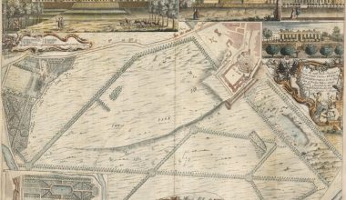
| 6 | A PLAN / of the / CITY OF ALBANY. / Situated Lat. 42.o 30′ Long. 74.o’ [5a][note] with a Design for the better securing it by altering the ancient form of its Stockade adding a Ditch in Front defended by a Number of / Block houses with a Banquette within from which a double Fire of Musquetry can be made thro loop holes in the Stockade. [1a, ob – 5a, ob] Also a Design for a Magazine for Provisions, Barracks for to Compleat 1000 Men with a General Hospital for 400 Sick and a small / Quay for the Conveniency of Loading & Unloading the Vessels which will also serve for a Battery for 2 Guns to Command the River. [1e, ob – 5e, ob][scale] ‘Scale 60 Feet’ – ’60’ (46mm) | Plan: 119 x 150 |
| 7 | A PLAN of the TOWN of HALIFAX in NOVA SCOTIA. [2a, ob – 4a, ob][key] ‘A-I.’ [5e][scale] ‘English Feet’ – ‘500’ – [1000] (37mm) [1e] ‘Echelle de Toises’ – ‘150’ (34mm) [3e] | Plan: 121 x 164 |
| 8 | PLAN / OF / FORT FRONTENAC. [1a][key] A-I, K, L. [1b][scale] [not given] | Plan: 120 x 150 |
| 9 | SKETCH of / FORT BREWERTON, / at the West End of / ONEDA LAKE. [5a][no key][scale] ‘Scale 100 Feet to an Inch’ – ‘300’ (40mm) [2a] | Plan: 120 x 149 |
| 10 | SKETCH of the / STOCKADE FORT, / at / OSWEGO FALLS. [5a][no key][scale] ‘Scale of 100 Feet to an Inch’ – ‘200’ [2b] | Plan: 120 x 151 |
| 11 | [‘Fort / William / Henry.’][scale] ‘Scale to this Plan of the Fort’ – ‘400’ (101mm) [2a-5a]Inset: ‘Section through A.B.’ [1d/e – 5d/e] [scale] ‘A Scale to the Profile’ – ‘110’ (83mm) [2d-4d] | Plan: 156 x 111 |
| 12 | PLAN of the NARROWS / about 10 Miles from / NEW YORK. / [key] A.B.C.D.E. … [2d/e – 4d/e][scale] ‘1000 Feet to an Inch’ – ‘4000’ (49mm) [2a-4a] | Plan: 120 x 151 |
| 13 | Plan and Profile of Retrenched Work round Harkemeis house at y.e German Flats 1756. [2e, ob – 4e, ob][scale] – ’40 Feet’ (36mm) [1e] | Plan: 120 x 150 |
| 14 | SCETCH / of the / BLOCK HOUSE / at the East of / ONEDA LAKE. [1e][scale] ‘Scale of 100 Feet to an Inch’ – ‘500’ (62mm) [1a-2a]Inset: ‘Elevation & Profile / of the Block house / through A.B.’ [3d] [scale] ‘Scale for the Elevation’ – ’50 Feet’ (46mm) | Plan: 119 x 151 |
| 15 | A PLAN of the / ROYAL BLOCK HOUSE, / with the Environs / at FORT EDWARD. [5a][scale] ‘Scale of 1200 Feet’ – ‘1200’ (53mm) [1e, ob – 2e, ob]’Scale of 20 Feet to an Inch’ – ‘130’ (35mm) [4e, ob – 5e, ob]Inset: [‘ROYAL BLOCK / HOUSE’] [5e] | Plan: 120 x 150 |
| 16 | A PLAN of / Fort William Henry / and the / English Camps / & Retrenchments / with the / French different Camps / and Attack there upon. [1a][key] ‘A-B / [vertical rule] / C-D / [vertical rule] / E / [vertical rule] / F. / [vertical rule] / G-H.’ [1a, ob – 5a, ob] ‘I-K / [vertical rule] / [K, cont.], L / [vertical rule] / M-N / [vertical rule] / [N, cont.] / [vertical rule] / [N, cont.] O-P.’ [1e, ob – 5e, ob]Inset: [Untitled Plan Of The Fort] [5a] | Plan: 120 x 150 |
| 17 | A PLAN of the FORT / at / SARATOGA. / Lat. 43.o 20′ Long 73.o 30′. [5e][no key][scale] ‘Scale 50 Feet to an Inch’ – ‘250’ (42mm) [4b] | Plan: 120 x 164 |
| 18 | PLAN / of / PART OF FORT GEORGE, / with the Barracks &c. / Erected in the Year 1759. / Situated Lat 43.o Long 73.o 30′. [1e][key] ‘A, 1-3, B, / [B, cont] 6, 7.’ [1a, ob – 5a, ob][scale] ‘Scale 200 Feet to an Inch’ – ‘1200’ (76mm) [2a-4a] | Plan: 121 x 164 |
| 19 | PLAN / of the / RETRENCH’D CAMP, / at / FORT LIGONIER. [1a][key] ‘Explanation. / A-D / E-H / I, K-N. [1e-4e][scale] ‘Scale of 100 Feet to one Inch’ – ‘300’ (28mm) [5d] | Plan: 120 x 164 |
| 20 | PLAN / of / Fort Frederick / at / ALBANY. [3a]Inset: ‘Section thro CD.’ [2b-4b] ‘A View of the South-East side of the Fort. [2e-3e][key] ‘A-B.’ [3d][scale] [not given] | Plan: 128 x 164 |
| 21 | A PLAN / of the / NEW FORT / at / PITTS-BURGH / or / DU QUESNE / Nov.r 1759. / Situated in Lat. 40.o 20′ Long 80.o [5a][key] ‘Explanation. / A-H. [5b-5d][scale] ‘Scale for the Plan’ – ‘600’ (55mm) [2d-2b] | Plan: 120 x 160 |
| 22 | PLAN / of / FORT EDWARD. / Situated Lat. 43.o Lon. 72.o 30′. [5e][no key][scale] [not given] | Plan: 119 x 160 |
| 23 | [‘FORT / BEDFORD’ and environs] [3d][no key][scale] ‘Scale of 300 Feet’ – ‘300’ (39mm) [5a] | Plan: 131 x 164 |
| 24 | PLAN / OF THE NEW / FORTS & REDOUBTS, / at / CROWN POINT. / Explanation. / Corresponding with the General Plan. / A-B / [vertical rule] / C. / D. [3c/e – 5c/e][in three sections:][a] D [The Light Infantry Fort] [1a/c – 3a/c] [scale] [no graduations, 17 units] (41mm) [2a][b] B [Grenadier Fort] [3a/c – 5a/c] [scale] ‘Scale of 40 Feet to an Inch’ – ‘170’ (41mm) [4a-5a][c] ‘C’ [Light Infantry of Regiments Fort] [1c/e – 3c/e] [scale] [not given] | Border: 120 x 165 |
| 25 | PLAN / of the NEW / FORT AND REDOUBTS, / at / NEW CROWN POINT. [3a][no key][scale] ‘Scale for 100 Feet to an Inch’ – ‘400’ (58mm) [4e-5e] | Plan: 120 x 163 |
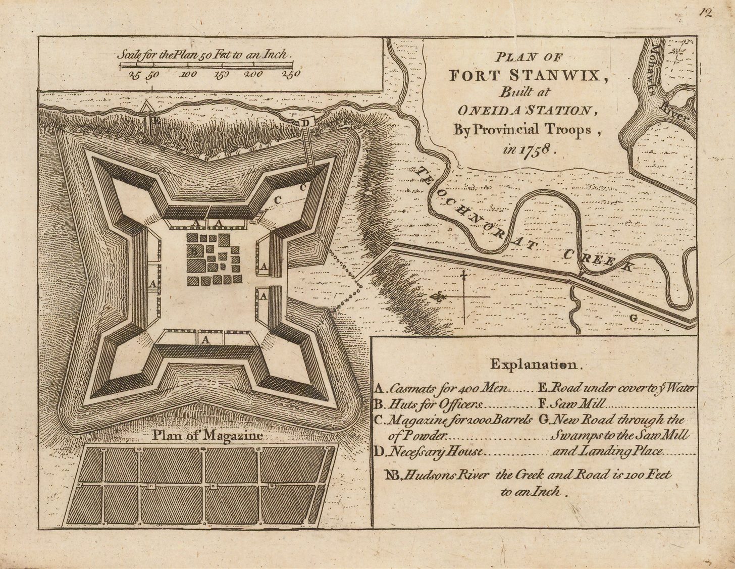
| 26 | PLAN OF / FORT STANWIX, / Built at / ONEIDA STATION, / By Provincial Troops, / in 1758. [4a]Inset: ‘Plan of Magazine’ [2e][key] ‘Explanation.. A-D / E-G.’ [3e-5e][scale] ‘Scale for the Plan 50 Feet to an Inch’ – ‘250’ (43mm) [2a] ‘NB. Hudsons River the Creek and Road is 100 Feet / to an Inch. [3d-4d] | Plan: 121 x 161 |
| 27 | A PLAN / of / FORT FREDERICK, / Situated at the / Entrance of S.t Johns River. / Lat 47.o Long. 66.o 30′. [1a][key] ‘Explanation. / A-F.’ [1b][scale] [not given] | Plan: 118 x 165 |
| 28 | PLAN OF FORT NIAGARA, / with its ENVIRON. / Explanation. / A-D / [vertical rule] / E-H. / I. [5e][scale] Scale / 100 Fathoms to an Inch’ – ‘200’ (49mm) [2e] | Plan: 121 x 165 |
| 29 | PLAN / OF THE FORT / at / TIENDEROGA / at / the HEAD of / Lake Champlain; / 1759. [1a][key] A-H / I, K-P, a. [1d-2d][scale] ‘Scale 400 Feet to an Inch’ [no units] (52mm) [2e-3e] | Plan: 122 x 164 |
| 30 | A PLAN of / FORT ONTARIO. [1a] P. Andrews Sculp. [4e, ob][key] 1-13. [5a-b][scale] ‘Scale of 200 feet to an Inch’ – ‘1000’ (61mm) [1e-2e]: | Plan: 119 x 164 |
| SECOND EDITION | ||
| A SET of / PLANS and FORTS / IN / AMERICA, / Reduced from Actual Surveys. / 1765. // Publish’d according to Act of Parliament, by Mary Ann Rocque Topographer to His Royal Highness the Duke of Gloucester, in the Strand. [1e, ob – 5e, ob] [London, 1763-] 1765 INDEX. [in 2 columns] / 1- 18 // [triple vertical rule] // 19-30. | Border: 123 x 166 | |
| 1 | A PLAN OF THE CITY OF NEW YORK, REDUCED FROM AN ACTUAL SURVEY, By T. Maerschalckm, 1763 [2a, ob – 4a, ob] P. Andrews Sculp. [1e, ob] Publish’d according to Act of Parliament by M.A. Rocque near Old Round Court in the Strand. [3e, ob] 1 [5a, ob] [key] ‘A-I, K / L-T, V / X-Z, 1-5.’ [4a-5a] [scale] ‘Scale of 1/4 of Mile or 1320 Feet’ – ‘700’ – [1500] (64mm) [4c] | Plan: 233 x 396State 2: with the plate number added; the date in the title has been changed to 1763. |
| 2 | A PLAN / of the / CITY OF ALBANY. / Situated Lat. 42.o 30′ Long. 74.o’ [5a] 2 [5a, ob] [note] with a Design for the better securing it by altering the ancient form of its Stockade adding a Ditch in Front defended by a Number of / Block houses with a Banquette within from which a double Fire of Musquetry can be made thro loop holes in the Stockade. [1a, ob – 5a, ob] Also a Design for a Magazine for Provisions, Barracks for to Compleat 1000 Men with a General Hospital for 400 Sick and a small / Quay for the Conveniency of Loading & Unloading the Vessels which will also serve for a Battery for 2 Guns to Command the River. [1e, ob – 5e, ob] [scale] ‘Scale 60 Feet’ – ’60’ (46mm) | Plan: 120 x 160State 2: with the plate number added. |
| 3 | PLAN of the TOWN / and FORTIFICATIONS / of / MONTREAL / or VILLE MARIE / in CANADA. [1a] 3 [5a, ob] [key] ‘A-I, K-N.’ [4a/b – 5a/b] [scale] ‘English Yards’ – ‘360’ (29mm) [4e] | Plan: 119 x 150State 2: with the plate number added. |
| 4 | PLAN of the CITY / and FORTRESS of / LOUISBOURG, with the Attacks. [5a] 4 [5e, ob] [key] ‘1-18’ [1b-1c] [scale] [not given] | Plan: 119 x 149State 2: with the plate number added. |
| 5 | PLAN OF QUEBEC, Reduc’d from an Actual Survey 1763. [2a, ob – 4a, ob] 5 [5a, ob] [key] ‘References. / A-I.’ [1d] [scale] [not given] | Plan: 122 x 164 Platemark: 137 x 180State 2: with the plate number added. |
| 6 | A PLAN / of / FORT FREDERICK, / Situated at the / Entrance of S.t Johns River. / Lat 47.o Long. 66.o 30′. [1a] 6 [5a, ob] [key] ‘Explanation. / A-F.’ [1b] [scale] [not given] | Plan: 118 x 165State 2: with the plate number added. |
| 7 | A PLAN of the TOWN of HALIFAX in NOVA SCOTIA. [2a, ob – 4a, ob] P. Andrews Sculp. [4e] 7 [5a, ob] [key] ‘A-I.’ [5e] [scale] ‘English Feet’ – ‘500’ – [1000] (37mm) [1e] ‘Echelle de Toises’ – ‘150’ (34mm) [3e] | Plan: 121 x 164State 2: with the plate number added, and the engraver’s name inserted. |
| 8 | A PLAN / of / SCHENECTADY. / Situated Lat. 43. Long. 74. 30. [1a] 8 [5a, ob] [key] ‘A-G.’ [2e-4e] [scale] ‘Scale of 200 Yards to an Inch’ – ‘1000’ (40mm) [4a] | Plan:121 x 165 Platemark: 141 x 190State 2: with the plate number added. |
| 9 | PLAN OF FORT NIAGARA, / with its ENVIRON. / Explanation. / A-D // [vertical rule] // E-H. / I. [5e] 9 [5a, ob] [scale] Scale / 100 Fathoms to an Inch’ – ‘200’ (49mm) [2e] | Plan: 121 x 165State 2: with the plate number added. |
| 10 | PLAN / of / Fort Frederick, / at / ALBANY. [3a] 10 [5a, ob] Inset: ‘Section thro CD.’ [2b-4b] ‘A View of the South-East side of the Fort. [2e-3e] [key] ‘A-B.’ [3d] [scale] [not given] | Plan: 128 x 164State 2: with the plate number added. |
| 11 | PLAN / OF THE FORT / at / TIENDEROGA / at / the HEAD of / Lake Champlain; / 1759. [1a] 11 [5a, ob] [key] A-H / I, K-P, a. [1d-2d] [scale] ‘Scale 400 Feet to an Inch’ [no units] (52mm) [2e-3e] | Plan: 122 x 164State 2: with the plate number added. |
| 12 | PLAN OF / FORT STANWIX, / Built at / ONEIDA STATION, / By Provincial Troops, / in 1758. [4a] 12 [5a, ob] Inset: ‘Plan of Magazine’ [2e] [key] ‘Explanation.. A-D / E-G.’ [3e-5e] [scale] ‘Scale for the Plan 50 Feet to an Inch’ – ‘250’ (43mm) [2a] ‘NB. Hudsons River the Creek and Road is 100 Feet / to an Inch. [3d-4d] | Plan: 121 x 161State 2: with the plate number added. |
| 13 | PLAN / of / FORT EDWARD. / Situated Lat. 43.o Lon. 72.o 30′. [5e] 13 [5a, ob] [no key] [scale] [not given] | Plan: 119 x 160State 2: with the plate number added. |
| 14 | PLAN / of / PART OF FORT GEORGE, / with the Barracks &c. / Erected in the Year 1759. / Situated Lat 43.o Long 73.o 30′. [1e] 14 [5a, orb] [key] ‘A, 1-3, B, / [B, cont] 6, 7.’ [1a, ob – 5a, ob] [scale] ‘Scale 200 Feet to an Inch’ – ‘1200’ (76mm) [2a-4a] | Plan: 121 x 164State 2: with the plate number added. |
| 15 | PLAN of the NARROWS / about 10 Miles from / NEW YORK. / [key] A.B.C.D.E. … [2d/e – 4d/e] 15 [5a, ob] [scale] ‘1000 Feet to an Inch’ – ‘4000’ (49mm) [2a-4a] | Plan: 120 x 151State 2: with the plate number added. |
| 16 | PLAN / of the / RETRENCH’D CAMP, / at / FORT LIGONIER. [1a] 16 [5a, orb] [key] ‘Explanation. / A-D / E-H / I, K-N. [1e-4e] [scale] ‘Scale of 100 Feet to one Inch’ – ‘300’ (28mm) [5d] | Plan: 120 x 164State 2: with the plate number added. |
| 17 | Plan and Profile of Retrenched Work round Harkemeis house at y.e German Flats 1756. [2e, ob – 4e, ob] 17 [5a, orb] [scale] – ’40 Feet’ (36mm) [1e] | Plan: 120 x 150State 2: with the plate number added. |
| 18 | [‘FORT / BEDFORD’ and environs] [3d] 18 [5a, ob] [no key] [scale] ‘Scale of 300 Feet’ – ‘300’ (39mm) [5a] Plan: 131 x 164 | Plan: 131 x 164State 2: with the plate number added. |
| 19 | SCETCH / of the / BLOCK HOUSE / at the East of / ONEDA LAKE. [1e] 19 [5a, orb] [scale] ‘Scale of 100 Feet to an Inch’ – ‘500’ (62mm) [1a-2a] Inset: ‘Elevation & Profile / of the Block house / through A.B.’ [3d] [scale] ‘Scale for the Elevation’ – ’50 Feet’ (46mm) | Plan: 119 x 151State 2: with the plate number added. |
| 20 | A PLAN of the FORT / at / SARATOGA. / Lat. 43.o 20′ Long 73.o 30′. [5e] 20 [5a, orb] 20 [1e, ob, engraved upside down] [no key] [scale] ‘Scale 50 Feet to an Inch’ – ‘250’ (42mm) [4b] | Plan: 120 x 164State 2: with the plate number added. |
| 21 | A PLAN of / Fort William Henry / and the / English Camps / & Retrenchments / with the / French different Camps / and Attack there upon. [1a] [key] ‘A-B / [vertical rule] / C-D / [vertical rule] / E / [vertical rule] / F. / [vertical rule] / G-H.’ [1a, ob – 5a, ob] ‘I-K / [vertical rule] / [K, cont.], L / [vertical rule] / M-N / [vertical rule] / [N, cont.] / [vertical rule] / [N, cont.] O-P.’ [1e, ob – 5e, ob] [scale] ‘A Scale of this Plan of 100 Yards’ – ‘700’ (65mm) [2e-4e] Inset: [Untitled Plan Of The Fort] [5a] | Plan: 120 x 150State 2: with the plate number added. |
| 22 | A PLAN of the / ROYAL BLOCK HOUSE, / with the Environs / at FORT EDWARD. [5a] 22 [5a, orb] [scale] ‘Scale of 1200 Feet’ – ‘1200’ (53mm) [1e, ob – 2e, ob] ‘Scale of 20 Feet to an Inch’ – ‘130’ (35mm) [4e, ob – 5e, ob] Inset: [‘ROYAL BLOCK / HOUSE’] [5e] | Plan: 120 x 150State 2: with the plate number added. |
| 23 | PLAN / of the NEW / FORT AND REDOUBTS, / at / NEW CROWN POINT. [3a] 23 [5a, orb] [no key] [scale] ‘Scale for 100 Feet to an Inch’ – ‘400’ (58mm) [4e-5e] | Plan: 120 x 163State 2: with the plate number added. |
| 24 | PLAN / OF / FORT FRONTENAC. [1a] 24 [5a, ob] [key] A-I, K, L. [1b] [scale] [not given] | Plan: 120 x 150State 2: with the plate number added. |
| 25 | PLAN / OF THE NEW / FORTS & REDOUBTS, / at / CROWN POINT. / Explanation. / Corresponding with the General Plan. / A-B / [vertical rule] / C. / D. [3c/e – 5c/e] [in three sections:] [a] D [The Light Infantry Fort] [1a/c – 3a/c] 25 [5a, ob] [scale] [no graduations, 17 units] (41mm) [2a] [b] B [Grenadier Fort] [3a/c – 5a/c] [scale] ‘Scale of 40 Feet to an Inch’ – ‘170’ (41mm) [4a-5a] [c] ‘C’ [Light Infantry of Regiments Fort] [1c/e – 3c/e] [scale] [not given] | Border: 120 x 165State 2: with the plate number added. |
| 26 | [‘Fort / William / Henry.’] 26 [5a, ob] [scale] ‘Scale to this Plan of the Fort’ – ‘400’ (101mm) [2a-5a] Inset: ‘Section through A.B.’ [1d/e – 5d/e] [scale] ‘A Scale to the Profile’ – ‘110’ (83mm) | Plan: 156 x 111State 2: with the plate number added. |
| 27 | SKETCH of the / STOCKADE FORT, / at / OSWEGO FALLS. [5a] P. Anbrows Sculp. [1a, ob, engraved upside down, the ‘d’ and ‘s’ of Andrews both engraved in reverse] 27 [5a, orb] 28 [1e, ob, engraved upside down] [no key] [scale] ‘Scale of 100 Feet to an Inch’ – ‘200’ [2b] | Plan: 120 x 151State 2: with the plate number added, and the engraver’s name inserted. |
| 28 | A PLAN / of the / NEW FORT / at / PITTS-BURGH / or / DU QUESNE / Nov.r 1759. / Situated in Lat. 40.o 20′ Long 80.o [5a] 28 [5a, orb] [key] ‘Explanation. / A-H. [5b-5d] [scale] ‘Scale for the Plan’ – ‘600’ (55mm) [2d-2b] | Plan: 120 x 160State 2: with the plate number added. |
| 29 | SKETCH of / FORT BREWERTON, / at the West End of / ONEDA LAKE. [5a] 29 [5a, orb] [no key] [scale] ‘Scale 100 Feet to an Inch’ – ‘300’ (40mm) [2a] | Plan: 120 x 149State 2: with the plate number added. |
| 30 | PLAN of / FORT ONTARIO. [1a] P. Andrews Sculp. [4e, ob] 30 [5a, ob] [key] 1-13. [5a-b] [scale] ‘Scale of 200 feet to an Inch’ – ‘1000’ (61mm) [1e-2e] | Plan: 119 x 164State 2: with the plate number added. |