| 1. | [1548] GASTALDI, Giacomo NVEVA HISPANIA TABVLA NOVA . [1a, ob – 4a, ob] From: Ptolemy Geografia Venice 1548 |  131 x 172Not in Cumming; Burden, North America, 17 (pl.17). |
| 2. | [1561] RUSCELLI, Girolamo NVEVA HISPANIA TABVLA NOVA. [2a, ob – 4a, ob] From: Ptolemy / Ruscelli La Geografia Di Clavdio Tolomeo … Venice, 1561 | 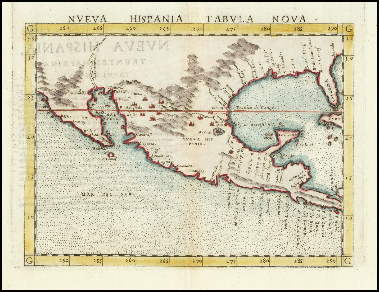 180 x 245Not in Cumming; Burden, North America, 31 (pl.31). |
| 3. | [1561] RUSCELLI, Girolamo: state 2 1561-1574 NVEVA HISPANIA TABVLA NOVA. [2a, ob – 4a, ob] From: Ptolemy / Ruscelli La Geografia Di Clavdio Tolomeo … Venice, 1574 | State 2: with minor re-working to the plate, including the addition of cross-hatching to the graduations. For this issue the original copper plate has been cut in two, so the platemark is visible outside the upper border.Not in Cumming; Burden, North America, 31; |
| 4. | [1561] RUSCELLI, Girolamo: state 3 1561-1598 NVEVA HISPANIA TABVLA NOVA. [2a, ob – 4a, ob] 180 x 245 PM: – x 262 From: Ptolemy / Ruscelli Geografia Di Claudio Tolomeo … Venice, 1598 | 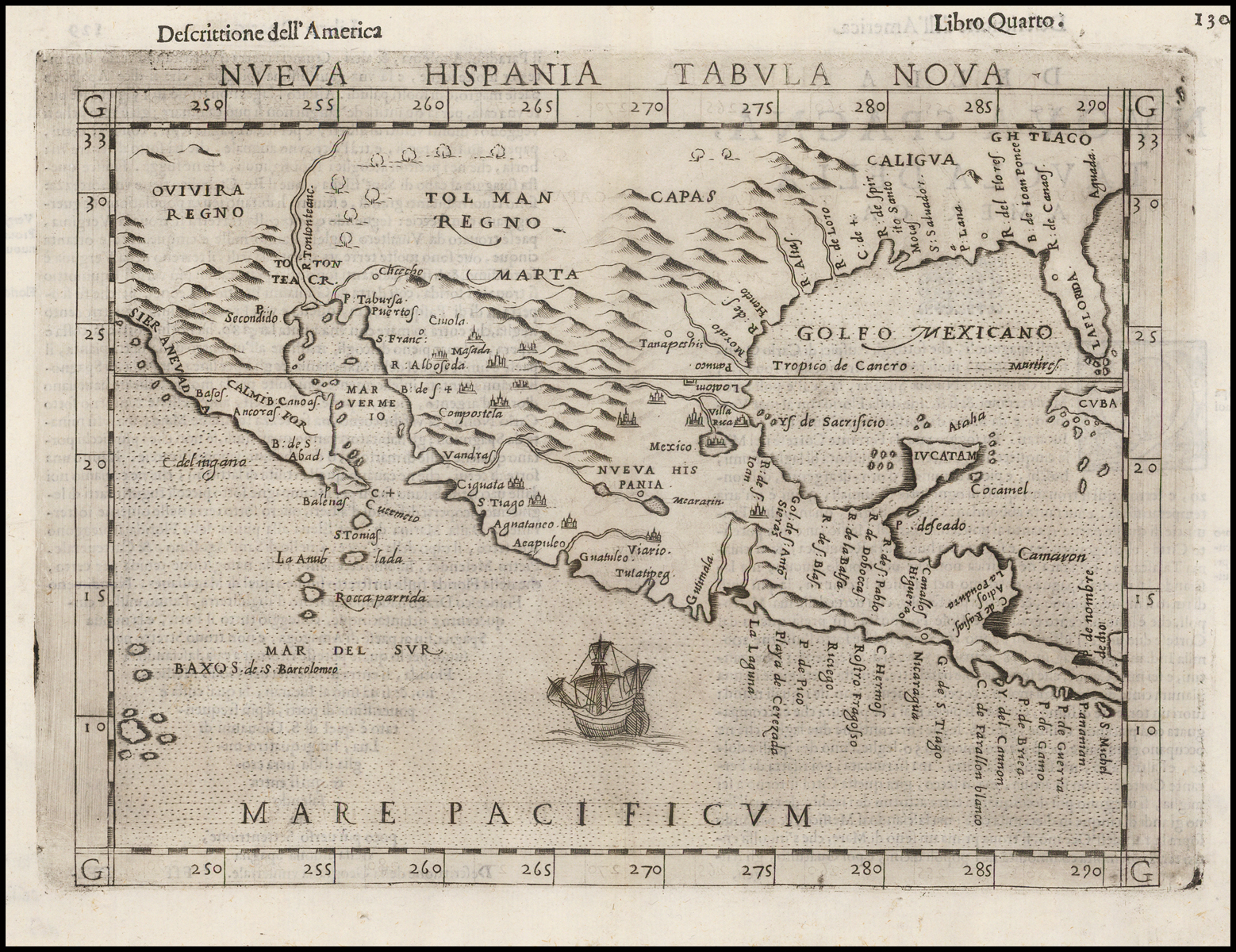 State 3: with minor re-working to the plate. ‘MARE PACIFICVM’ (with a ship) and ‘GOLFO MEXICANO’ are so named; within the map ‘CALMIFOR’ (for California) and ‘SIERA NEVAD’ are inserted.Not in Cumming; Burden, North America, 31; |
| 5. | [1584] ORTELIUS, Abraham] LA FLORIDA. / Auctore Hieron: Chiaues. [2e] Cum Priuilegio. [5a] [on sheet with] ‘PERVVIAE / AVRIFERÆ / REGIONIS / TYPVS. / Didaco Mendezio. auctore.’ & ‘GVAS / TECAN / Reg.’ From: Ortelius Additamentum III Theatri … Antwerp, 1584 | 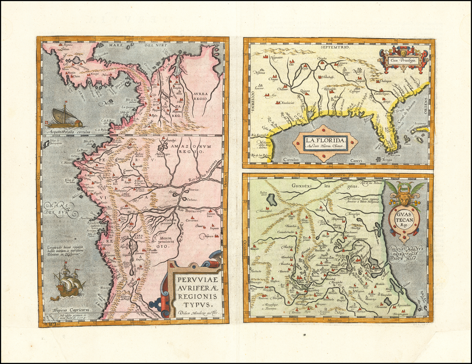 Florida: 153 x 225 Guastecan: 175 x 222 Peru: 336 x 223 Border: 333 x 461 PM: 340 x 463Cumming, 5 (pl.9); Burden, North America, 57 (pl.57). |
| 6. | [1591] LE MOYNE, Jacques FLORIDAE AMERICAE PROVINCIAE / Recens & exactissima descriptio / Auctore Iacobo le Moyne cui co= / gnomen de Morgues, Qui Laudo[n]= / nierum, Altera Gallorum in eam / Prouinciam Nauigatione comitat’ / est, Atque adhibitis aliquot militibus, / Ob pericula, Regionis illius interi= / ora & Maritima diligentissime / Lustrauit, & Exactissime dimensus / est, Obseruata etiam singulorum / Fluminum inter se distantia, ut ipse= / met redux Carolo IX, Galliarum / Regi, demonstrauit. [5c] From: Le Moyne Brevis Narratio Eorvm Qvae In Florida … Theodore de Bry, Frankfurt-am-Main, 1591 | 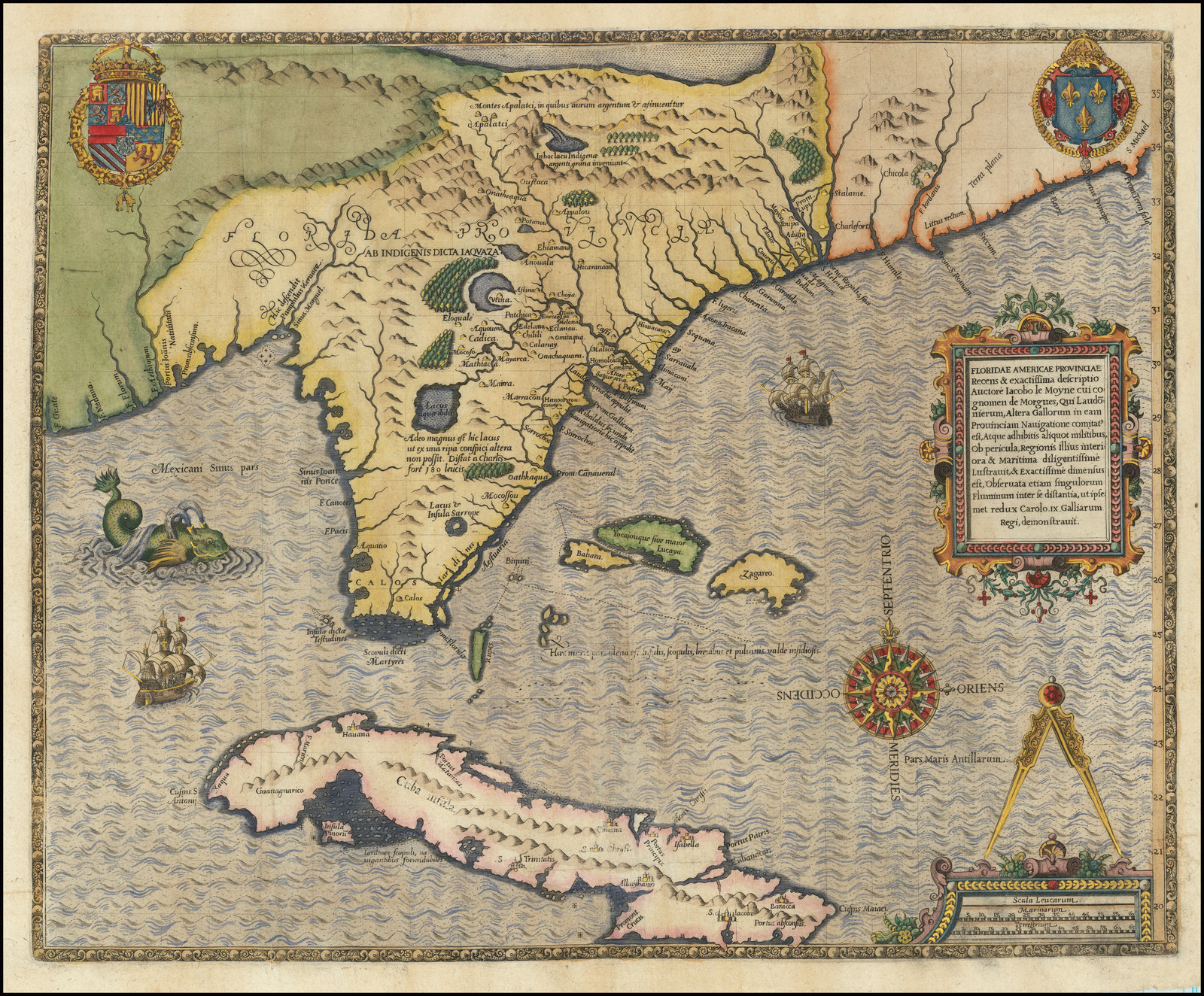 365 x 450Cumming, 14 (pl.15); Burden, North America, 79 (pl.79). |
| 7. | [1597] WYTFLIET, Cornelis FLORIDA / et / APALCHE. [5a] 16 [5a, in border] From: Wytfliet Descriptionis Ptolemaicae Augumentum … Louvain, 1597 | 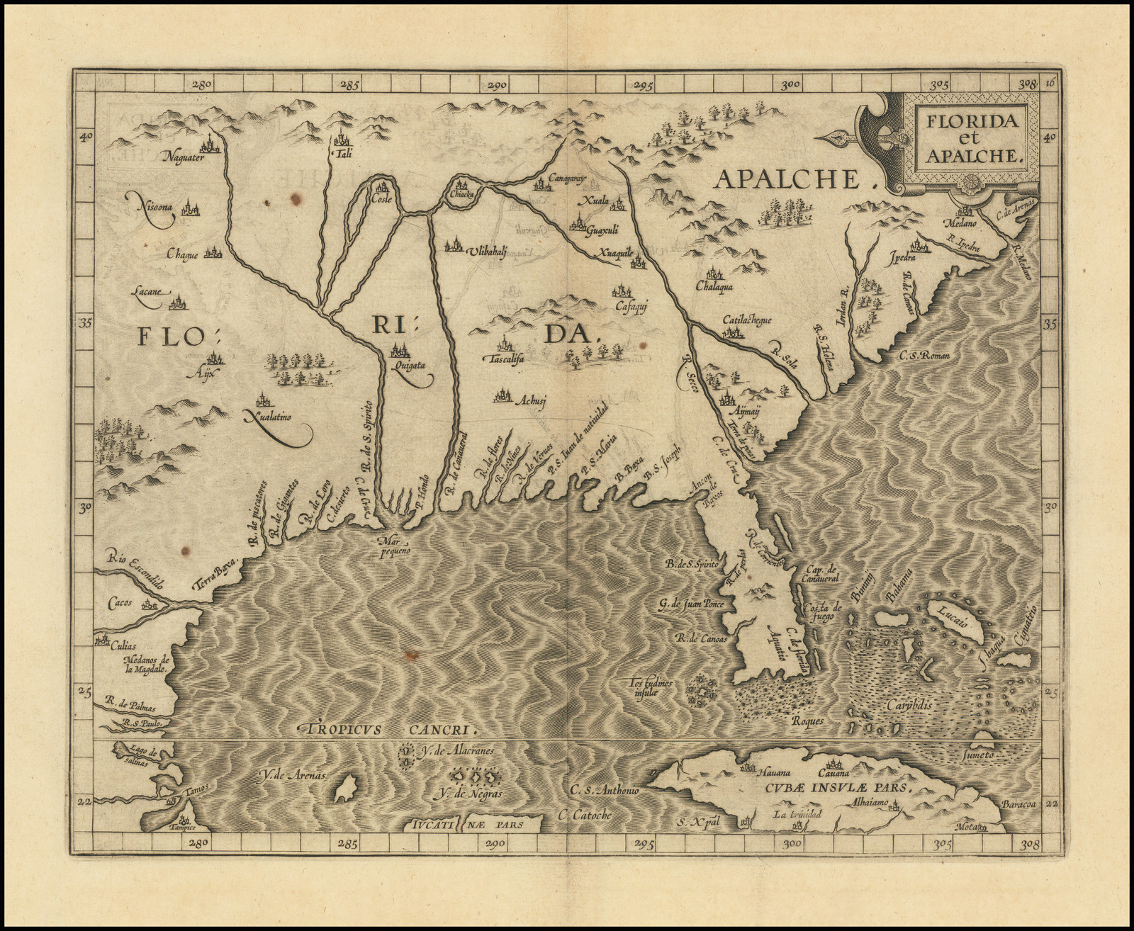 230 x 290Cumming, 18 (pl.17); Burden, North America, 104 (pl.104). |
| 8. | [1598] ACOSTA, José de FLORIDA / et / APALCHE. [5c] From: Acosta … Landschafft America … Cologne, 1598 | 175 x 235Cumming, 20; Burden, North America, 119 (pl.119). |
| 9. | [1630] DE LAET, Johannes FLORIDA. / et / REGIONES VICINAE. [4a] From: De Laet Nieuve Wereldt … Leiden, 1630 | 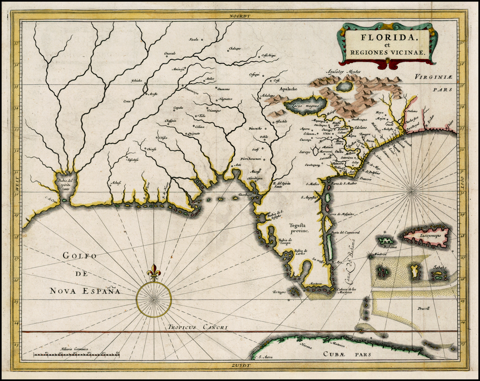 281 x 357 PM: 285 x 361Cumming, Southeast, 35; Burden, North America, 232 (pl.232). |
| 10. | 1656 SANSON, Nicolas: state 1 LE NOUVEAU MEXIQUE, / et LA FLORIDE: / Tirées de diverses Cartes, et Relations. / Par N. SANSON d’Abbeville Geogr. ord.re du Roy. / A PARIS. / Chez Pierre Mariette, Rue S. Iacque a l’Esperance / Avec Privilege du Roy, pour vingt Ans. / 1656. [4a] Somer Sculp. [4e, in border] From: Sanson Cartes Generales De Toutes Les Parties Du Monde … Paris, 1658 | 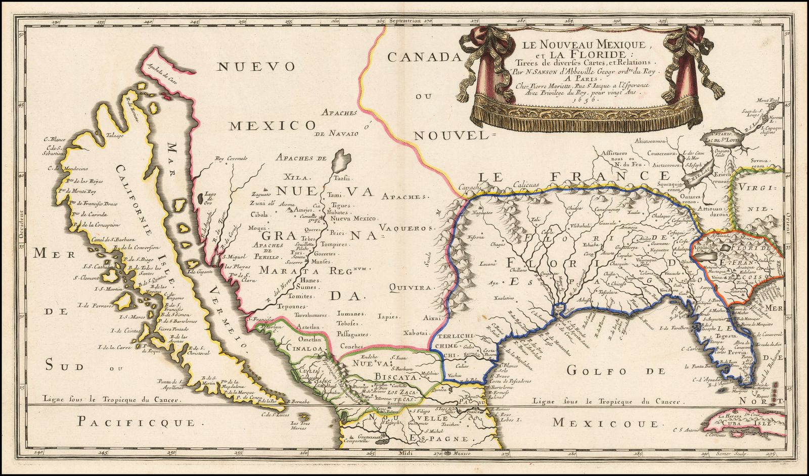 310 x 545Cumming, 49 (pl.31: right half); Burden, North America, 319 (pl.319). |
| 11. | 1656 SANSON, Nicolas: state 2 1656-1675 ca LE NOUVEAU MEXIQUE, / et LA FLORIDE: / Tirées de diverses Cartes, et Relations. / Par N. SANSON d’Abbeville Geogr. ord.re du Roy. / A PARIS. / Chez l’Autheu[r] / Avec Privilege du Roy, pour vingt Ans. / 1656. [4a] Somer Sculp. [4e, in border] From: Sanson Cartes Generales De Toutes Les Parties Du Monde … Paris, 1658 | State 2: with the imprint now reading ‘… Chez L’Auteu [sic] …’Cumming, 49; Burden, North America, 319: state 2. |
| 12. | 1656 SANSON, Nicolas state 3 1656-1675 ca LE NOUVEAU MEXIQUE, / et LA FLORIDE: / Tirées de diverses Cartes, et Relations. / Par N. SANSON d’Abbeville Geogr. ord.re du Roy. / A PARIS. / Chez l’Autheur / Avec Privilege du Roy, pour vingt Ans. 1656. [4a] Somer Sculp. [4e, in border] From: Sanson Cartes Generales De La Geographie … Paris, 1675 | State 3: with ‘Auteur’ now so spelled in the title. Cumming, 49; Burden, North America, 319: state 2. |
| 13. | 1656 SANSON, Nicolas: state 4 1656-1675 ca LE NOUVEAU MEXIQUE, / et LA FLORIDE: / Tirées de diverses Cartes, et Relations. / Par N. SANSON d’Abbeville Geogr. ord.re du Roy. / A PARIS. / Chez l’Autheur / Re. / Avec Privilege du Roy, pour vingt Ans. / 1656. [4a] Somer Sculp. [4e, in border] From: Sanson Cartes Generales De La Geographie … Paris, 1675 | State 4: with ‘Re.’ inserted in the title. Cumming, 49; Not in Burden, North America, 319. |
| 14. | 1656 SANSON, Nicolas: state 5 1656-1679 LE NOUVEAU MEXIQUE, / et LA FLORIDE: / Tirées de diverses Cartes, et Relations. / Par N. SANSON d’Abbeville Geogr. ord.re du Roy. / A PARIS. / Chez l’Autheur / Re. / Avec Privilege du Roy, pour vingt Ans. / 1679. [4a] Somer Sculp. [4e, in border] From: Sanson Cartes Generales De La Geographie Ancienne Et Nouvelle … Paris, 1679 | State 5: with the title now dated 1679. Cumming, 49; Burden, North America, 319, state 4. |
| 15. | 1657 SANSON, Nicolas: state 1 LA FLORIDE. / Par N. Sanson d’Abbeville / Geogr. ord.re du Roy / A PARIS / Chez l’Auteur Avecq. Privil / pour 20 Ans. / 1657. [3e] From: Sanson L’Amerique En Plusieurs Cartes … Paris, 1657 | 179 x 252Cumming, 53; Burden, North America, 326 (pl.326). |
| 16. | 1657 SANSON, Nicolas: state 2 1657-1662 ca LA FLORIDE. / Par N. Sanson d’Abbeville / Geogr. ord.re du Roy / A PARIS / Chez P. MARIETTE, rue S.t / Iacques a l’Esperance. / Avecq. Pri. pour 20 Ans. [3e] From: Sanson L’Amerique En Plusieurs Cartes … Paris, [n.d.] | State 2: with Mariette’s imprint substituted in the title. Cumming, 53; Burden, North America, 326, state 2; |
| 17. | 1657 SANSON, Nicolas: state 3 1657-1670 ca LA FLORIDE. / Par N. Sanson d’Abbeville / Geogr. ord.re du Roy / A PARIS / Chez P. MARIETTE, rue S.t / Iacques a l’Esperance. / Avecq. Pri. pour 20 Ans. [3e] 3 [5e] From: Sanson L’Amerique En Plusieurs Cartes … Paris, [n.d.] | State 3: with the plate number inserted. Cumming, 53; Burden, North America, 326: state 3. |
| 18. | 1657 SANSON, Nicolas: state 4 1657-1702 LA FLORIDE. / Par N. Sanson d’Abbeville / Geogr. ord.re du Roy / A PARIS / Chez l’Autheur aux Galleries de Louvre. Avec Pri. pour 20 ans. // 1702. [3e] 3 [5e] From: [?] | State 4: with the imprint re-engraved, and the map now dated 1702. Cmming, 53; Burden, North America, 326: state 4. |
| 19. | [1657 ca. ?] DUVAL, Pierre: state 1 [Untitled Map Of Florida] [text] La FLORIDE a esté soumise aux Espagnols apres que les Fran= / cois s’en fussent retiré de dedans du Pais est encore sous la domina[c]on de / petits Seigneurs quils appellent Paraoustis. Les uilles de S. Augustin, / et de S. Mathieu sont proche du Canal du Bahama. [1a, ob – 5a, ob] [on sheet entitled] L’AMERIQVE / Par P. Du Val Geographe du Roy. Pierre Duval Separate publication | 79 x 122 with text: 100 x 122 W: 400 x 488 PM: 402 x 492Burden, North America, 322. |
| 20. | [1657 ca. ?] DUVAL, Pierre state 2] 1657 – 1661 [Untitled Map Of Florida] [text] La FLORIDE a esté soumise aux Espagnols apres que les Fran= / cois s’en fussent retiré de dedans du Pais est encore sous la domina[c]on de / petits Seigneurs quils appellent Paraoustis. Les uilles de S. Augustin, / et de S. Mathieu sont proche du Canal du Bahama. [1a, ob – 5a, ob] [on sheet entitled] L’AMERIQVE / Par P. Du Val Geographe du Roy. / 1661 Auec Priuil. / A Paris Chez I. Lagniet sur le quay de la megisserie au fort lEuesque. Jean Lagniet Separate publication | State 2: the imprint has been added to the title.Burden, North America, 322: state 2 (pl.322). |
| 21. | [1657 ca. ?] DUVAL, Pierre state 3] 1657-1680 ca [Untitled Map Of Florida] [text] La FLORIDE a esté soumise aux Espagnols apres que les Fran= / cois s’en fussent retiré de dedans du Pais est encore sous la domina[c]on de / petits Seigneurs quils appellent Paraoustis. Les uilles de S. Augustin, / et de S. Mathieu sont proche du Canal du Bahama. [1a, ob – 5a, ob] [on sheet entitled] L’AMERIQVE / Par P. Du Val Geographe du Roy. / [with the imprint crudely erased] Anonymous Separate publication | State 3: the imprint has been crudely erased from the title.Not in Burden, North America, but cf.322. |
| 22. | [1660] DU VAL, Pierre: state 1 1660- FLORIDE [2d] From: Du Val Le Monde Terrestre … Paris, 1660 | 94 x 117 PM: 108 x 128Cumming, 55; Burden, North America, 352 (pl.352): state 1. |
| 23. | [1660?] DU VAL, Pierre: state 2 1660-1661 LA / FLORIDE / Par P. Du Val / G.O.D.R. [2d] From: Duval La Geographie Universelle En Plusieurs Cartes … Paris, 1661 | State 2: the title has been expanded, and a small numberof additions made within the map: ‘Lac / Erie’ [4a], ‘Nouueau / Mexique’ [1b] and ‘Caro / line / ou / Charles ford’ [4c] are all named. Cumming, 55 (pl.33); Burden, North America, 352: state 2. |
| 24. | [1660?] DU VAL, Pierre: state 3 1660-1672 LA / FLORIDE / Par P. Du Val / G.O.D.R. [2d] From: Duval Le Monde Ou La Geographie Universelle … Paris, 1672 | State 3: ‘Caro / line / ou / Charles ford’ has been erased,and ‘Charles / fort’ and ‘la Caroline’ engraved over the partially erased marks [4c]. An unnamed lake in ‘Floride / Francoise’ is now named ‘Melilot’ [4b] ‘Nouvelle / Espa= / gne’ is named [1d] Cumming, 55; Burden, North America, 352: state 3. |
| 25. | [[1660?] DU VAL, Pierre state 4] 1660-1682 ca LA / FLORIDE / Par P. Du Val / G.O.D.R. [2d] 10 [5e] From: Duval Le Monde Ou La Geographie Universelle … Paris, 1682 | State 4: with the plate number inserted. Cumming, 55; Burden, North America, 352: state 3. |
| 26. | [1678] SELLER, John: state 1 FLORIDA. [3a, ob] From: Seller Book Of Geography London,[1678] | IB: 75 x 53 B: 95 x 56[Separate table] FLORIDA / is Divided into / these V Parts. / …’ ‘V’Cumming, Southeast, 87. |
| 27. | [1678] SELLER, John: state 2 1678-1679 ca. FLORIDA. [3a, ob] From: Seller Atlas Minimus London, [1678] | State 2: the original title has been erased, and replaced by new, larger, lettering, set within a plain rectangular frame.Cumming, 87. |
| 28. | [1679] [DUVAL-] ANONYMOUS] FLORIDA. [2d] 85 [5a, in border] From: [Duval] Geographiae Universalis Pars Prior… Nuremberg, 1679 | 95 x 118Cumming, 86. |
| 29. | [1679] [SANSON /] ANONYMOUS FLORIDA, / Per N. Sanson. [3e] From: [Sanson] Geographia Exactissima … Frankfurt, 1679 | 178 x 255 PM: 186 x 261Cumming, 84. |
| 30. | [1681] MOORE, Jonas FLORIDA. [2d] From: Moore New Systeme Of Geography … London, 1681 | 97 x 114 Page: 203 x 114 PM: 215 x 173Cumming, 90. |
| 31. | [1683] MALLET, Alain Manesson 1683- FLORIDE. [3a] 295 [5a] [letterpress heading] ‘DE L’AMERIQUE / FIGURE CXXVIII’ ‘295’ ‘T iiij’ From: Mallet Description De L’Univers … Paris, 1683 | 114 x 151 PM: 117 x 155Cumming, 95. |
| 32. | [1683] D’WINTER, Anthony: state 1 LA FLORIDE / Par N. Sanson / d’Abbeville / Geogr. Ord.re du Roy. [3e] From: [Sanson] L’Amerique En Plusieurs Cartes … Utrecht, 1683 | 177 x 251 PM: 183 x 258Cumming, 97. |
| 33. | [1683] D’WINTER, Anthony: state 2 1683-1700 LA FLORIDE / Par N. Sanson / d’Abbeville / Geogr. Ord.re du Roy. [3e] From: [Sanson] Description De Tout L’Univers … Amsterdam, 1700 | State 2: a graticule has been added across the face of the map; ‘Lac Grande’ is named in Floride Francoise; the boundaries between Canada and Floride, and between Nouveau Mexique and Floride are now shown by a double line; within the map additional mountains and trees are added; the title cartouche has been re-worked slightly: the lower face now has eyes, and the pattern of shading differs. Cumming, 97. |
| 34. | [1683] D’WINTER, Anthony: state 3 1683-1705 FLORIDA zoo als het van de Spaanschen en Franschen wordt bezeten, door N. Sanson, geog. Ord.re du Roy. From: Pherotee De La Croix Algemeene Weereld-Beschreibung … Amsterdam, 1705 | State 3: the title has now been re-engraved in Dutch. Cumming, 139. |
| 35 | [1683] D’WINTER, Anthony: state 4 1683-1734 LA FLORIDE / Par N. Sanson / d’Abbeville / Geogr. Ord.re du Roy. [3e] From: Du Sauzet Atlas Portatif … Amsterdam, 1734 | 176 x 252 PM: 183 x 259State 4: the Dutch title has been erased, and replaced by a French title |
| 36. | [1683] D’WINTER, Anthony: state 4 1683-1738 LA FLORIDE / Par N. Sanson / d’Abbeville / Geogr. Ord.re du Roy. [3e] 261 [5a, in border] From: Du Sauzet Atlas Portatif … Amsterdam, 1734 [1738] | State 5: with the plate number added. Not in Cumming. |
| 37. | [1686] [MALLET /] ANONYMOUS FLORIDE. [3a] engraved heading: ‘das Landt Florida’ ‘Fig. 18’ From: [Mallet] Description De L’Univers … Frankfurt, 1686 | 114 x 149 PM: 123 x -Cumming, 106. |
| 38. | [1692] MULLER, Johann Ulrich] [Untitled Map Of ‘Florida / Hispanica’ and ‘Florida Fran / cica’] VI [3a, ob] From: Muller Kurz-Bundige Abbild-Und Vorstellung Der Gantzen Welt Ulm, 1692 | 114 x 149 PM: 123 x -Cumming, 112. |
| 39. | [1701] MOLL, Herman MEXICO, or New SPAIN, Divided into the Audiance of GUADALAYARA, MEXICO, and GUATIMALA FLORIDA. From: Moll A New System Of Geography … London, 1701 | 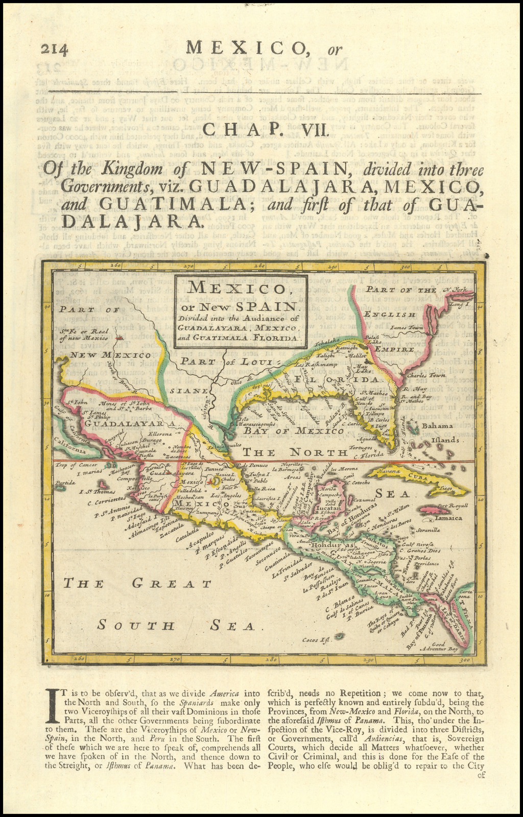 164 x 179 PM: 179 x 185Cumming, 133. |
| 40. | [1706] AA, Pieter van der Chicora: state 1 DE / VASTE KUST / Van / CHICORA / Tussen / FLORIDA en VIRGINIE, / Door / Lucas Vasquez d’Ayllon / En Andere, van / HISPANIOLA / Besterend. [5b] Uytgevoered te LEYDEN door PIETER VANDER AA met Privilegie. [1e, ob – 2e, ob] Alonso d’Ojeda. [5e, ob] Pag: 89 [5a, in border] From: van der Aa … Reysen Na Oost En West-Indien … Leiden, 1707 | 164 x 179 PM: 179 x 185Cumming, 141. |
| 41. | [1706] AA, Pieter van der Chicora: state 2 1706-1714 DE / VASTE KUST / Van / CHICORA / Tussen / FLORIDA en VIRGINIE, / Door / Lucas Vasquez d’Ayllon / En Andere, van / HISPANIOLA / Besterend. [5b] Terre-Ferme de Chicora, entre la Floride et la Virginie, decrite par Lucas Vasquez d’Ayllon sur les Voiyages de Don Alonso d’Ojeda, et d’autres qui y ont navige de l’Ile Hispaniola presentement mise en lumiere par Pierre vander Aa, a Leide. Avec Privilege. [1e, ob – 5e, ob] From: van der Aa Atlas Nouveau Et Curieux Des Plus Celebres Itineraires … Leiden, 1714 | State 2: the second title has been engraved outside the lower border, replacing van der Aa’s imprint. The page number has been erased. Cumming, 141. |
| 42. | [1706] AA, Pieter van der Florida: state 1 ‘T AMERIKAANS Gewest van FLORIDA Door FERDINAND DE SOTO Nader Ondekt en Groot deels Bemagtigd.’ ‘Uytgevoerd te LEYDEN door PIETER VANDER AA met Privilegie.’ ‘Ferdinand de Soto. [5e, ob] ‘Pag: 1’ From: van der Aa … Reysen Na Oost En West-Indien … Leiden, 1707 | 148 x 225Cumming, 142; |
| 43. | [1706] AA, Pieter van der Florida: state 2 1706-1714 T AMERIKAANS Gewest van FLORIDA Door FERDINAND DE SOTO Nader Ondekt en Groot deels Bemagtigd.’ ‘Uytgevoerd te LEYDEN door PIETER VANDER AA met Privilegie.’ ‘Ferdinand de Soto. [5e, ob] ‘Pag: 1’ ‘LA FLORIDE, Grand Pais de l’Amerique Septentrionale, plus avant decouverte et presque toute conquise par Ferdinand de Soto en 1534. tiree de ses Memoires, et de tous ceux qui ont paru jusques a present, nouvellement rendue publique par Pierre vander Aa, a Leide. Avec Privilege. [1e, ob – 5e, ob] From: van der Aa Atlas Nouveau Et Curieux Des Plus Celebres Itineraires … Leiden, 1714 | 150 x 225 Frame: 217 x 285State 2: with the new title outside the lower border: The map is printed set in a wide frame surround, printed from a separate plate. Cumming, 142. |
| 44. | [1706] AA, Pieter van der Florida: state 3 1706- T AMERIKAANS Gewest van FLORIDA Door FERDINAND DE SOTO Nader Ondekt en Groot deels Bemagtigd. Garcilasso de la Vega Histoire De La Conquete De La Floride … Leiden, 1731 | 164 x 179 PM: 179 x 185State 3: without the frame border, or any of the lettering outside the map. Cumming, 142. |
| 45. | [1706] AA, Pieter van der Dickenson: state 1 1706- JONATHAN / DICKENSON / Ramspoedige / REYSTOGT / van / JAMAIKA / na / PENSYLVANIA / nagespoord. [3a] Uytgevoerd te LEYDEN door PIETER VANDER AA met Privilegie. [1e, ob -2e, ob] Jonathan Dickenson. [5e, ob] Pag: 1 [5a, in border] From: van der Aa … Reysen Na Oost En West-Indien … Leiden, 1707 | 148 x 232 PM: 156 x 237Not in Cumming. |
| 46. | [1706] AA, Pieter van der Dickenson state 2 1706-1714. JONATHAN / DICKENSON / Ramspoedige / REYSTOGT / van / JAMAIKA / na / PENSYLVANIA / nagespoord. [3a] Infortuné Voyage de Jonathan Dickenson, fait de la Jamaique en Pensylvanie, suivant ses Relations, et rendu plus pairfaits par de nouvelles Observations de differens Voyageurs, qui y ont / été apres lui, a present publié par Pierre vander Aa, à Leide. Avec Privilege. [1e, ob – 5e, ob] From: van der Aa Atlas Nouveau Et Curieux Des Plus Celebres Itineraires … Leiden, 1714 | 151 x 231State 2: The page number has been erased, and the second title engraved outside the lower border. The map is set within a wide elaborate frame surround, printed from a separate plate. |
| 47. | [1713] AA, Pieter van der: state 1 LA FLORIDE, / suivant les Nouvelles Observations / de / Mess.rs de 1’Academie Royale / des Sciences, etc. / Augmentees de Nouveau. / A LEIDE, / Chez Pierre vander Aa, Avec Privilege. [3d] From: Aa Le Nouveau Theatre Du Monde … Leiden, 1713 | Cumming, 133. |
| 48. | [1713] AA, Pieter van der: state 1, issue 2 1713-1729 LA FLORIDE, / suivant les Nouvelles Observations / de / Mess.rs de 1’Academie Royale / des Sciences, etc. / Augmentees de Nouveau. / A LEIDE, / Chez Pierre vander Aa, Avec Privilege. [3d] From: Aa La Galerie Agreable Du Monde Leiden, [1729] | Issue 2: the map is printed set in wide frame border, printed from a separate plate, with the map of Canada printed above.Cumming, 133. |
| 49. | [1713] AA, Pieter van der: state 2 1713-1735 ca. LA LOUISIANE, / suivant les Nouvelles Observations / de / Mess.rs de 1’Academie Royale / des Sciences, etc. / Augmentees de Nouveau. / A Amsterdam chez Covens et Mortier.’ ’96’ From: Covens & Mortier Nouvel Atlas … Amsterdam, [1735] | Cumming, 224. |
| 50. | 1728 MOLL, Herman: state 1 FLORIDA / Calle’d by y.e French LOUISIANA &c. / By H. Moll Geographer 1728. [3e] Moll Atlas Minor … London, 1729 | 200 x 272 PM: – x 282Cumming, 201. |
| 51. | 1728 MOLL, Herman: state 2 1729-1732 FLORIDA / Calle’d by y.e French LOUISIANA &c. / By H. Moll Geographer. [3e] 54 [5a, ob] Moll Atlas Minor … London, 1732 | State 2: the date has been deleted from the title, as also the erroneous apostrophe in the title; the plate is now numbered ’54’. ‘GEORGIA’ is named [4c], and the note ‘Charakeys / 30 Vill.’ added within the map [4b]. Cumming, 201. |
| 52. | [1731] CATESBY, Mark A MAP OF / CAROLINA, FLORIDA / AND THE / BAHAMA ISLANDS / with the Adjacent Parts. [4b] Catesby The Natural History Of Carolina … London, 1731 | 437 x 507 PM: 443 x 511Although frequently found in volume I of this book, the map is a later insertion, prepared between 1733 and 1743. Cumming, 210. |
| 53. | [1748] BOWEN, Emanuel A NEW MAP of GEORGIA with Part of CAROLINA, FLORIDA and LOUISIANA. / Drawn from Original Draughts, assisted by the most Approved Maps and Charts, / Collected by Eman: Bowen Bowen, Geographer to his Majesty. [1a-5a] Vol.II p.323 [5a] John Harris Navigantium Atque Itinerantium Biblithoeca … London, 1744-1748 | 437 x 507 PM: 443 x 511Cumming, 267. |
| 54. | 1749 ROBERT DE VAUGONDY, Didier: state 1 1749- LA FLORIDE / divisee en / FLORIDE et CAROLINE / Par le S.r Robert de Vaugondy / Fils de M.r ROBERT Geogr. ordin. du Roi. / Avec Privilege / 1749. / [scale bar] [1e] 189 [5a, orb] Robert de Vaugondy Atlas Portatif … Paris, [1749] | 165 x 170Cumming, 271. |
| 55. | 1749 ROBERT DE VAUGONDY, Didier: state 2 1749- LA FLORIDE / divisee en / FLORIDE et CAROLINE / Par le S.r Robert de Vaugondy / Fils de M.r ROBERT Geogr. ordin. du Roi. / Avec Privilege / 1749. / [scale bar] [1e] 61 [5a, orb] Robert de Vaugondy Atlas Portatif … Paris, [1749 but later] | State 2: with the plate number ’61’ substituted. Cumming, 271. |
| 56. | [1749 ROBERT DE VAUGONDY, Didier state 3] 1749- LA FLORIDE / divisee en / FLORIDE et CAROLINE / Par le S.r Robert de Vaugondy / Fils de M.r ROBERT Geogr. ordin. du Roi. / Avec Privilege / [scale bar]. [1e] 93 [5a, orb] Robert de Vaugondy Atlas Portatif … Paris, [1749 but later] | 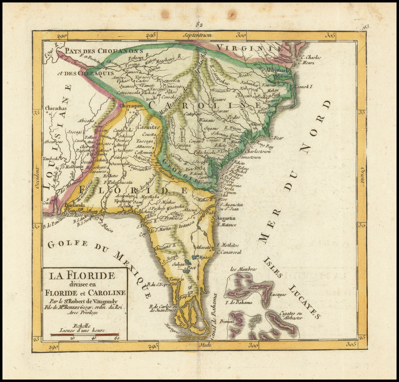 State 3: with the plate number ’93’ substituted, and the date erased from the title. Not in Cumming, 271. |
| 57. | [1750] [DE L’ISLE /] ALBRIZZI, Girolamo Carta Geografica Della Florida Nell’America Settentrionale. From: Albrizzi Atlante Novissimo … vol.II Venice, 1750 | 330 x 427Cumming, 277. |
| 58 | 1755 BALDWIN, Richard 1755- A MAP of Virginia, North and South Carolina, Georgia, Maryland with part of New Jersey &c.’ ‘Printed for R. Baldwin in pater noster Row. 1755. From: The London Magazine vol.24, for July 1755, opp. p.312 London, 1755 | 213 x 265 PM: 227 x 274Cumming, 294. |
| 59. | [1755 ca.] NOLIN, Jean-Baptiste PARTIE / MÉRIDIONALE / des possessions Angloises / en / AMÉRIQUE. / Dressée sur les mémoires / de J.B. Nolin / Geog. du Roy. [4d] 36 [5a] From: [?] | 203 x 258 PM: 224 x 278Not in Cumming. |
| 60. | [1755 [CATESBY /] SELIGMANN, Johann Michael CAROLINAE / FLORIDAE nec non INSVLARVM / BAHAMENSIVM / cum partibus adjacentibus / delineatio / ad Exemplar Londinense / in lucem edita / a / Ioh. Michael Seligmann / Norimbergae A:o 1755. [4b] From: [Catesby] Die Beschreibung Von Carolina … Nuremberg, 1755 | 427 x 585Cumming, 292. |
| 61. | [1758] LOPEZ DE VARGAS, Tomas La Florida. From: Lopez Atlas Geographico De La America … Madrid, 1758 | Cumming, 315. |
| 62. | 1758 SEPP, Christian CARTE DE LA LOUISIANE, MARYLAND, VIRGINIE, CAROLINE, GEORGIE, avec une Partie de la FLORIDE. / A AMSTERDAM chez COVENS & MORTIER, 1758. [1a, ob – 5a, ob] C. Sepp sculpsit. [1e] From: Covens & Mortier Atlas Nouveau … Amsterdam, [1761] | 394 x 589 PM: 432 x 598Cumming, 316 |
| 63. | [1762] GIBSON, John A New & Correct / MAP / of the Provinces of / NORTH & SOUTH / CAROLINA, / GEORGIA, & FLORIDA. [4d] J. Gibson sculp.t [5e] From: Gibson The American Gazetteer … London, 1762 | 276 x 348 PM: 285 x 357Cumming, 316. |
| 64. | [1775] ADAIR, James A Map of the American Indian Nations, adjoining to the Missisippi, West & East Florida, Georgia, S. & N. Carolina, Virginia, &c.’ ‘Jn.o Lodge Sculp.’ From: Adair The History Of The American Indians … London, 1775 | Cumming, 448. |
| 65. | 1776 SANTINI, François: state 1 PARTIE MÉRIDIONALE / de la / LOUISIANE, / avec la / FLORIDE, la CAROLINE / et la / VIRGINIE, / PAR LE S.r D ANVILLE. / A VENISE / Par P. Santini / 1776. [4d] From: Santini Atlas Universel … Venice, 1776 [1780] | 480 x 574 PM: 492 x 584 |
| 66. | 1776 SANTINI, François: state 2 1776-1784 PARTIE MÉRIDIONALE / de la / LOUISIANE, / avec la / FLORIDE, la CAROLINE / et la / VIRGINIE, / PAR LE S.r D ANVILLE. / A VENISE / Par P. Santini / chez Remondini. [4d] P.II.48 [5a, ob] From: Santini Atlas Universel … Venice, 1784 | Sellers & van Ee, 1408. |
| 67. | 1776 SAYER, Robert & BENNETT, John: state 1 A GENERAL MAP OF THE / SOUTHERN BRITISH COLONIES, / IN AMERICA. / comprehending / NORTH AND SOUTH CAROLINA, / GEORGIA, / EAST AND WEST FLORIDA, / with THE NEIGHBOURING INDIAN COUNTRIES. / From the Modern Surveys of / Engineer de Brahm, Cap.t Collett, Mouzon & Others; / and from the Large Hydrographical Survey of the Coasts / of East and West Florida. / By B. ROMANS. / 1776. [5e] The SEAT of WAR, in the SOUTHERN BRITISH COLONIES, comprehending NORTH and SOUTH CAROLINA, GEORGIA, EAST and WEST FLORIDA &ca. [2a, ob – 4a, ob] London. Printed for R. Sayer and J. Bennett, Map, Chart & Printsellers, N.o 53 Fleet Street, as the Act directs 15.th Oct. 1776. [3e, ob] Inset: ‘PLAN OF CHARLESTOWN’ [key] ‘References / a-g.’ [scale] ”Scale of feet’ – ‘2100’ (28mm) [5b] ‘PLAN OF S.t AUGUSTINE.’ [key] ‘References. / a-h.’ [scale] ‘Two Furlongs’ – ‘2’ (26mm) [5c] From: Sayer & Bennett American Military Pocket Atlas … London, 1776 | 503 x 644 Widest: 509 x 644MCS 39, no.78a; Sellers & van Ee, 1396(ill). |
| 68. | 1776 SAYER, Robert & BENNETT, John: state 2 1776-1794 A NEW AND GENERAL MAP / OF THE SOUTHERN DOMINIONS BELONGING TO / THE UNITED STATES OF AMERICA, / viz: NORTH CAROLINA, SOUTH CAROLINA / AND GEORGIA: / with THE BORDERING INDIAN COUNTRIES, / AND THE SPANISH POSSESSIONS / OF LOUISIANA AND FLORIDA. / [rule] / LONDON. / Published by LAURIE & WHITTLE, N.o 53, Fleet Street. / as the Act directs, 12.th May, 1794. [5e] Inset: ‘PLAN OF / CHARLESTOWN’ [5b] ‘PLAN OF / S.t AUGUSTINE.’ [5c] From: Laurie & Whittle New Universal Atlas … London, [1794] | 497 x 637 PM: 523 x 669State 2: with the title altered following the establishment of the United States.MCS 39, no.78b (a later issue, circa 1809, shows Louisiana coloured as part of the united States, although the plate is apparently unchanged, MCS 39, no.79c). |
| 69. | [1781] LODGE, John A MAP of / EAST and WEST FLORIDA, GEORGIA and LOUISIANA, / with the Islands of CUBA, BAHAMA, / and the COUNTRIES surrounding the / GULF of MEXICO, with / the Tract of the Spanish Galleons, / and of our Fleets thro the Straits of Florida, / from the Best Authorities. [1d] Jn. Lodge Sculp. [5e, ob] London. Published as the Act directs, May 31.st 1781, by J. Bew, Pater Noster Row. [3e, ob] [scale] [not given] Extent: Mexico / Texas Coast – ‘C. Roman or / Carteret’, northern tip of Yucatan, most of Cuba, and western Bahamas, including the western tip of Providence 276 x 370 PM: 292 x – From: The Political Magazine … vol.2 opp. p.293, for May 1781, London | 274 x 363 |
| 70. | [1782] BONNE, Rigobert: state 1 Carte de la Louisiane et de la Floride. Par M. Bonne Ingenieur-Hydrogr.phe de la Marine.’ ‘Liv. XVI. No. 46’ Inset: ‘Supplement’ [Missouri River] From: Bonne Atlas De Toutes Les Parties Connues Du Globe Terrestre … Paris, [1782] | 274 x 363Cumming, 326; Sellers & van Ee, 1401. |
| 71. | [1782] BONNE, Rigobert: state 2 1782-1788 Carte de la Louisiane et de la Floride. Par M. Bonne Ingenieur-Hydrogr.phe de la Marine.’ ‘Liv. XVI. No. 46’ Inset: ‘Supplement’ [Missouri River] From: Bonne Atlas De Toutes Les Parties Connues Du Globe Terrestre … Paris, [1782] | State 2: with the word ‘Supplement’ missing from the inset. Sellers & van Ee, 1401 |
| 72. | 1782 BRION DE LA TOUR, Louis SUITE DU THEATRE DE LA GUERRE DANS LYAMERIQUE SEPTENTRIONALE Y COMPRIS LE GOLFE DU MEXIQUE par M. Brion de la Tour, Ing.r Geographe du Roi. A Paris, chez Esnauts et Rapilly rue Saint Jacques a la ville de Coutances. 1782. From: Esnauts & Rapilly Separate publication | 740 x 510 |
| 73. | 1783 CARY, John: state 1 ‘THE WEST INDIES, including PART of VIRGINIA, NORTH CAROLINA, EAST FLORIDA, SOUTH CAROLINA, WEST FLORIDA, GEORGIA, LOUISIANA, and the Gulf of Mexico, with Part of the Coast of SOUTH AMERICA: From the BAY of HONDURAS, to the Mouth of the RIVER ORONOKO, From the Latest and Best Authorities and Actual Observations.’ ‘London Publish’d as the Act directs, Aug.st 1783 by Jn.o Cary Map & Printseller, N.o 188 corner of Arundel Street Strand. From: Cary Separate publication | 570 x 714 PM: 585 x 728Sellers & van Ee, 1713 |
| 74. | 1783 CARY, John: state 2 1783-1785 ca ‘THE WEST INDIES, including PART of VIRGINIA, NORTH CAROLINA, EAST FLORIDA, SOUTH CAROLINA, WEST FLORIDA, GEORGIA, LOUISIANA, and the Gulf of Mexico, with Part of the Coast of SOUTH AMERICA: From the BAY of HONDURAS, to the Mouth of the RIVER ORONOKO, From the Latest and Best Authorities and Actual Observations.’ ‘London Publish’d as the Act directs, Aug.st 1783 by Jn.o Cary Map & Printseller, N.o 188 corner of Arundel Street Strand. From: Cary Separate publication | State 2: Hispaniola is no longer divided into French and Spanish sections, and an explanatory note has been deleted. Sellers & van Ee, 1714 |
| 75. | 1788 PURCELL, Joseph: state 1 A / MAP / of the States of / VIRGINIA NORTH CAROLINA / SOUTH CAROLINA and GEORGIA / Comprehending the Spanish Provinces of / EAST and WEST FLORIDA / Exhibiting the Boundaries as fixed by the late Treaty of Peace between the UNITED STATES and the SPANISH DOMINIONS. / Compiled from late Surveys & Observations. By / Joseph Purcell. [5d] Engrav’d for Morse’s Geography by Amos Doolittle at New Haven 1788. [2e, ob – 3e, ob] From: [Noah Webster Jr.] American Magazine … New York, 1788 | 368 x 303Wheat & Brun, 491 |