| 1548 | [1548]: GASTALDI, Giacomo TIERRA // NVEVA. [2a, ob & 4a, ob]From: Claudius Ptolemy Ptolomeo. La Geografia …, Venice, 1548 | Copper engraving, 131 x 172mm.Burden: North America, 16 (pl.16).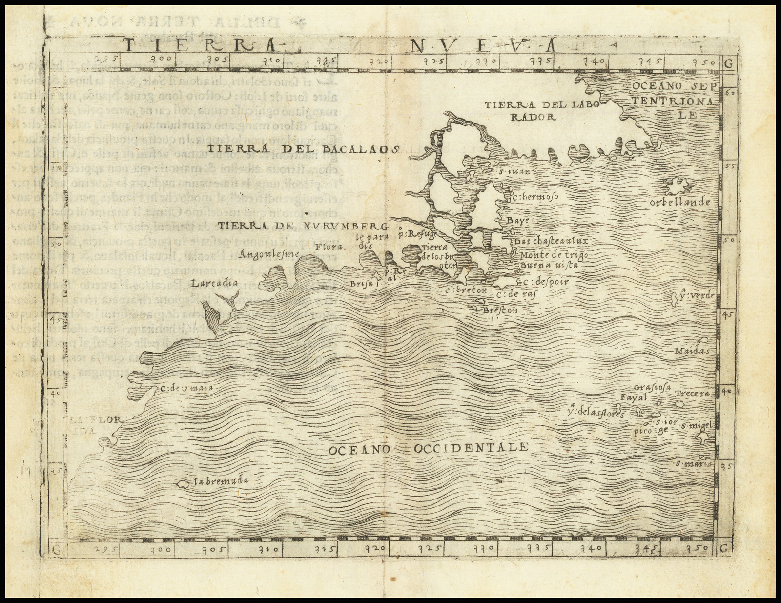 |
| 1556 | [1556]: RAMUSIO, Giovanni Battista [Untitled Map of ‘LA NVOVA FRANCIA’ & ‘TERRA NVOVA’]From: Ramusio Delle Navigationi Et Viaggi …, Venice, 1556, vol. 3 | Woodcut, 267 x 372mm.From the first of two very similar woodblocks. The second block can be identified by the presence of weeping willow trees, for example along the left hand border.Burden: North America, 25 (pl.25).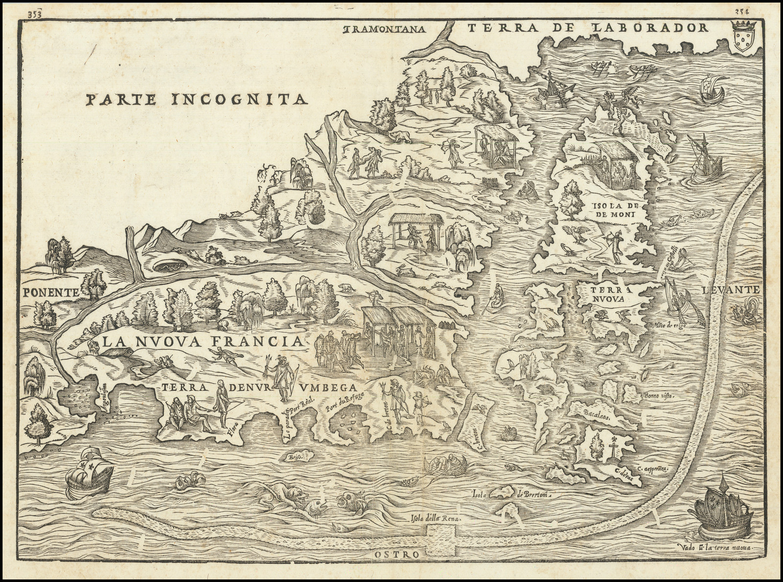 |
| 1561:01a | [1561]: RUSCELLI, Girolamo state 1 TIERRA NVEVA< [2a, ob – 4a, ob]From: Claudius Ptolemy [Ruscelli ed.] La Geografia Di Clavdio Tolomeo Alessandrino …, Venice, 1561 | Copper engraving, 180 x 244 PM: – x 262mm.In the first state, this map is one of two printed from a single plate. The platemark is visible extending upwards off the pageBurden: North America, 30 (pl.30): Goss, America, 9 (ill); |
| 1561:01b | [1561] – [1574]: RUSCELLI, Girolamo state 2 TIERRA NVEVA< [2a, ob – 4a, ob]From: Claudius Ptolemy [Giovanni Malombra ed.] La Geografia Di Clavdio Tolomeo Alessandrino …, Venice, 1574 | State 2: the plate has been cut down, so that a platemark is visible outside the upper border. At the same time, the plate was reworked.Burden: North America, 30: state 2.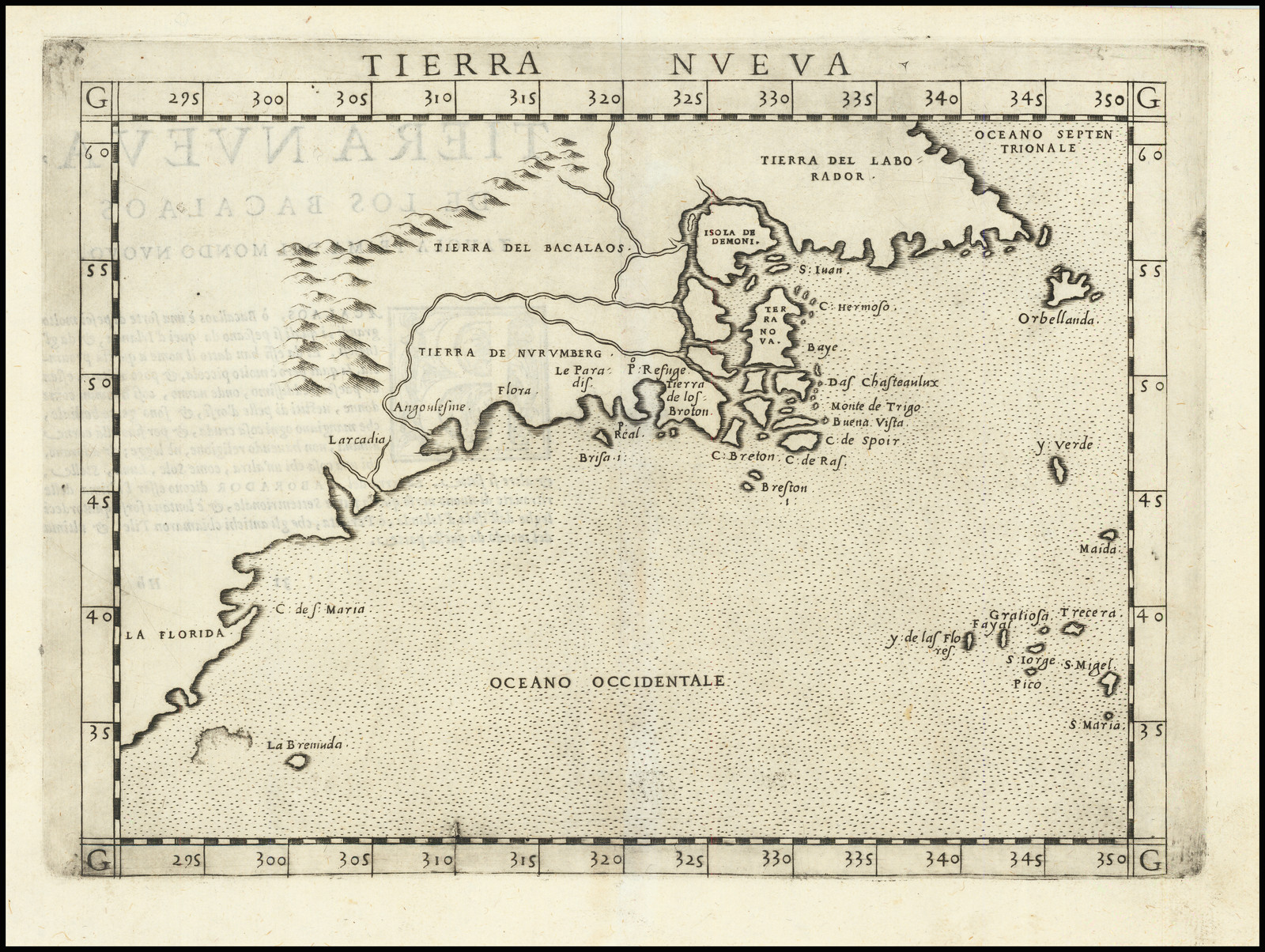 |
| 1561:01c | [1561] – [1598]: RUSCELLI, Girolamo state 3 TIERRA NVEVA< [2a, ob – 4a, ob]From: Claudius Ptolemy [Giuseppe Rosaccio ed.] Geografia Di Clavdio Tolomeo Alessandrino …’, Venice, 1598 | State 3: the plate has again been reworked, with many additions, including the following place names: ‘VIRGINIA’, ‘AVAGAL’, ‘INDIA NOVA’ ‘NOVA FRANCIA’ ‘Porto de St. Helena’ ‘TERRA CORTE REAL’. Some ships, a sea monster, mountains and islands have also been added.Burden: North America, 30: state 3. |
| 1565:01a | [1565]: RAMUSIO, Giovanni Battista state 1 [Untitled Map of ‘LA NVOVA FRANCIA’ & ‘TERRA NVOVA’]From: Ramusio Delle Navigationi Et Viaggi …, Venice, 1565, vol. 3 | Woodcut, 267 x 372mm.This example is printed from a new block, which can most easily be distinguished from the first block by the weeping willow trees [1d, 1c & 2c]. There is an additional sea-monster between the ship and the two fighting sea-monsters [2b].The letterpress pagination outside the upper border is ‘424’ and ‘425’, as for the first block.Burden: North America, 30: state 1. |
| 1565:01. | [1565] – [1606]: RAMUSIO, Giovanni Battista state 2 [Untitled Map of ‘LA NVOVA FRANCIA’ & ‘TERRA NVOVA’]From: Ramusio Delle Navigationi Et Viaggi …, Venice, 1606, vol. 3 | ‘State 2’: while being stored in the printing shop, the block was attacked by woodworm, who ate parts of the block. This damage appears as white tracks across the image, most noticeable in the sea along the lower borderBurden: North America, 30 (pl.35): state 2. |
| 1597:01a | [1597]: WYTFLIET, Cornelis state 1 NORVMBEGA / ET / VIRGINIA. / 1597. [1a] 17 [5a, in border]From: Wytfliet Descriptio Ptolemaicae Augmentum …, Louvain, 1597 | Copper engraving, 229 x 291mm.Burden: North America, 103 (pl.103); Cumming: Southeast, 19; On The Map, fig.4. |
| 1597:01b | [1597] – [1607]: WYTFLIET, Cornelis state 2 NORVMBEGA / ET / VIRGINIA. [1a] 17 [5a, in border]From: Wytfliet Histoire Universelle Des Indes Occidentales …, Douai, 1607 | 230 x 294 PM: 232 x 297mm.State 2: the date has been erased from the title.Burden: North America, 103: state 2.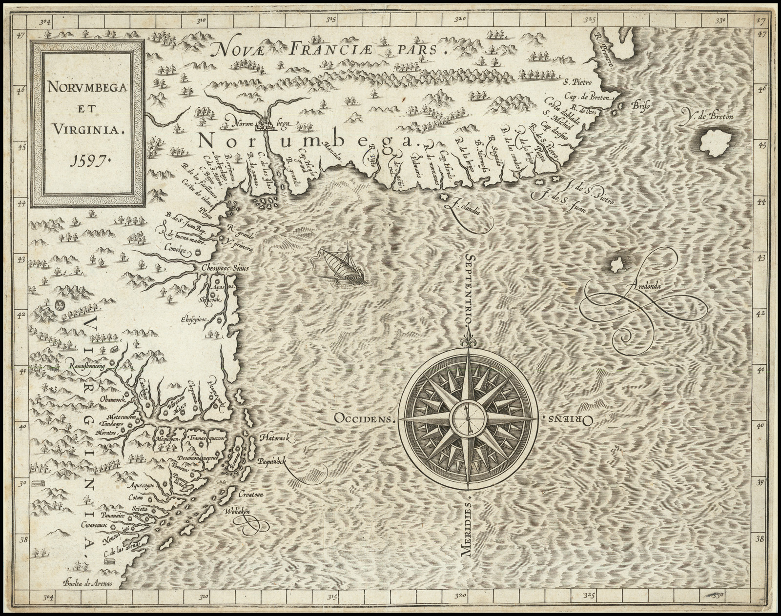 |
| 1597:01c. | [1597] – [1611]: WYTFLIET, Cornelis state 3 NORVMBEGA / ET / VIRGINIA. [1a] 17 [5a, in border]From: Wytfliet Histoire Universelle Des Indes Occidentales …, Douai, 1611 | State 3: in previous states, in the left hand border, the latitude, reading up from the lower corner ran ’38’ – ’30’ – ’40 (etc). In this state, the error has been corrected [1d, in border].Burden: North America, 103: state 3. |
| 1598:01 | [1598]: ACOSTA, Jose d’ NORVM / BEGA / ET / VIRGINIA. [1a]From Acosta Geographische Und Historische Beschreibung Der Uberauss Grosser Landshafft America … Cologne, 1598From: Metellus Speculum Orbis Terrae …, Cologne, 1600From: Metellus America, Sive Novvs Orbis …, Cologne, 1600 | Copper engraving, 180 x 230mm.A German derivative of Wytfliet’s map, published by Johannes Metellus.Meurer: Atlantes Coloniensis, ACO.1.(6) [Aco 7] & MET.9.(6) [Met.189]; Burden: North America, 119 (pl.119); Cumming: Southeast, 21 & 22, not realising the same plate was involved in both printings; On The Map, fig.5. |
| 1616:01 | [1616]: HONDIUS, Jodocus Jr. VIRGINIA / et Nova Francia. [5e] From: Petrus Bertius Tabularum Geographarum Contractarum … Amsterdam, 1616 | Copper engraving, 93 x 135 PM: 96 x 138mm.Burden: North America, 185 (pl.185); Cumming: Southeast, 31. |
| 1616:01a | [1616]: SMITH, John state 1 NEW ENGLAND / The most remarqueable parts thus named, / by the high and mighty Prince CHARLES, / Prince of great Britaine. [2a-3a] Observed and described by Captayn John Smith. [4d] Simon Pasæus sculpsit / Robert Clerke excudit. [2e] London / Printed by Georg: Low. [5e]From: Smith A Description Of New England …, London, 1616Inset: ‘THE PORTRAICTUER OF CAPTAYNE IOHN SMITH ADMIRALL OF NEW ENGLAND.’ Image: 120 x 90 [1a] [text] These are the Lines that shew thy Face; but those / That shew thy Grace and Glory, brighter bee= / Thy Faire-Discoueries and Fowle-Overthrowes / Of Salvages, much Civilliz’d by thee / Best shew thy Spirit; and to it Glory Wyn; / So, thou art Brasse without, but Golde Within. / If so; in Brasse, (too soft Smiths Acts to beare) / I fix thy Fame, to make Brasse Steele out weare. / Thine, as thou art Virtues, / John Dauies. Heref: [1b] | Copper engraving, 305 x 350mm.Church, 369: state 1; Burden: North America, 187, state 1; Streeter, II, 610 (ill); Cumming et al, Discovery, p.276 (ill).It should be noted that states of the map were often randomly issued in various of Smith’s books, so the sources of various states are for general guidance only.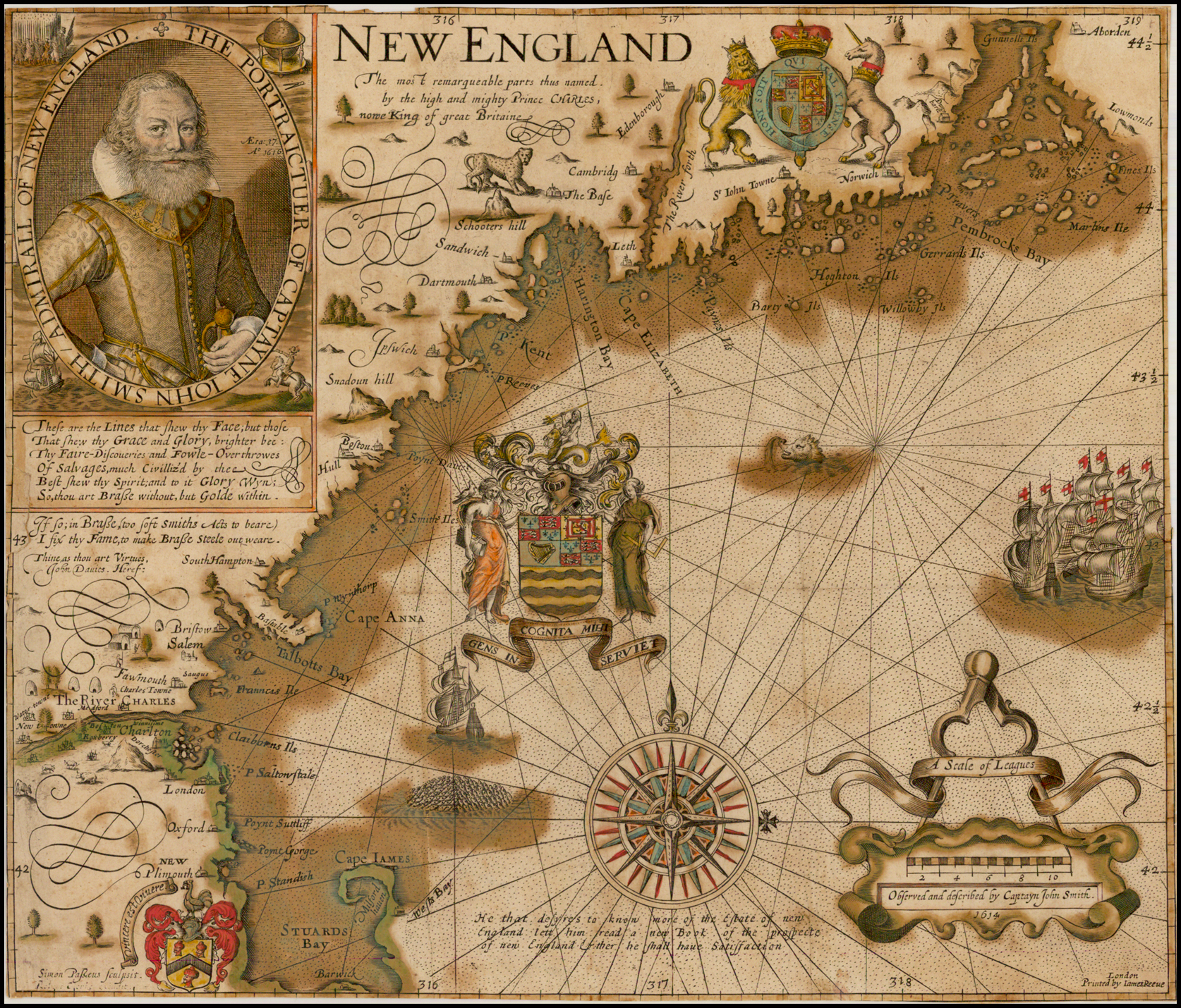 |
| 1616:01b | [1616] – [1616]: SMITH, John state 2 NEW ENGLAND / The most remarqueable parts thus named, / by the high and mighty Prince CHARLES, / Prince of great Britaine. [2a-3a] Observed and described by Captayn John Smith. [4d] Simon Pasæus sculpsit / Robert Clerke excudit. [2e] London / Printed by Georg: Low. [5e]From: Smith A Description Of New England …, London, 1616 | State 2: The date ‘1614’ has been added in the frame of the cartouche around Smith’s imprint [4d]; ‘P. Travers’ and ‘Gerrards Ils.’ are named [4b].Church 369: state 2 (suggesting a hypothetical intermediate state, dated 1614, but without the geographical additions, not seen by him); Burden: North America, 187, state 2; |
| 1616:01c | [1616] – [1624]: SMITH, John state 3 NEW ENGLAND / The most remarqueable parts thus named, / by the high and mighty Prince CHARLES, / Prince of great Britaine. [2a-3a] Observed and described by Captayn John Smith. [4d] Simon Pasæus sculpsit / Robert Clerke excudit. [2e] London / Printed by Georg: Low. [5e]From: Smith The Generall Historie Of Virginia, New-England, And The Summer Isles …, London, 1624 | State 3: Smith’s Arms have been inserted, without motto [2e].Church 369: state 3; Burden: North America, 187, state 3; |
| 1616:01d | [1616] – [1624]: SMITH, John state 4 NEW ENGLAND / The most remarqueable parts thus named, / by the high and mighty Prince CHARLES, / Prince of great Britaine. [2a-3a] Observed and described by Captayn John Smith. [4d] 1614 [4d] Simon Pasæus sculpsit. [2e] London / Printed by Georg: Low. [5e]From: Smith The Generall Historie Of Virginia, New-England, And The Summer Isles …, London, 1624 | State 4: The motto ‘Vincere est Viuere’ has been added to John Smith’s Arms [2e]; Robert Clerke’s name has been partially erased [2e]. Graduations of latitude have been added to the western (left) border, and of longitude in the upper and lower borders.Church 369: state 4; Burden: North America, 187, state 4; |
| 1616:01e | [1616] – [1626]: SMITH, John state 5 NEW ENGLAND / The most remarqueable parts thus named, / by the high and mighty Prince CHARLES, / Prince of great Britaine. [2a-3a] Observed and described by Captayn John Smith. [4d] 1614 [4d] Simon Passæus sculpsit. [2e] London / Printed by Georg: Low. [5e] From: Smith The Generall Historie Of Virginia, New-England, And The Summer Isles …, London, 1626 | State 5: Passe’s name has been altered to read ‘Passæus’ [2e] Cross-hatching has been added to the left side of Smith’s coat in the portrait, and in the background [1a]; within the map, ‘Paynes Ils.’ is named [3b].Church 369: state 5; Burden: North America, 187, state 5; |
| 1616:01f | [1616] – [1627]: SMITH, John state 6 NEW ENGLAND / The most remarqueable parts thus named, / by the high and mighty Prince CHARLES, / Prince of great Britaine. [2a-3a] Observed and described by Captayn John Smith. [4d] 1614 [4d] Simon Passæus sculpsit. [2e] London / Printed by Iames Reeue. [5e]From: Smith The Generall Historie Of Virginia, New-England, And The Summer Isles …, London, 1627 | State 6: James Reeve’s name has been subtituted for George Low’s, in the printer’s imprint [5e]Church 369: state 6; Burden: North America, 187, state 6; |
| 1616:01g | [1616] – [1631]: SMITH, John state 7 NEW ENGLAND / The most remarqueable parts thus named, / by the high and mighty Prince CHARLES, / nowe King of great Britaine. [2a-3a] Observed and described by Captayn John Smith. [4d] 1614 [4d] Simon Passæus sculpsit. [2e] London / Printed by Iames Reeue. [5e]From: Smith Advertisements For The Unexperienced Planters Of New-England …, London, 1631 | State 7: In the title, Prince Charles is described as ‘nowe King …’.Within the map, a large number of geographical alterations and additions have been made. Additions include ‘Martins Ile’ [5b], ‘P. Reeves’ [3b], ‘P. Wynthorp’ [2c], ‘Salem’ [2c], ‘Franncis Ile’ [2d], ‘Clairborns Ils.’ [2d], ‘P. Saltonstale’ [2d], ‘P. Standish’ [2d] and ‘Wests Bay’ [2d]. ‘Plimouth’ is now called ‘NEW / Plimouth’ [2d].The islands near ‘Clairborns Ile’ have been re-engraved, increasing their number from 8 to 19 [2d].Church 369: state 7; Burden: North America, 187, state 7 (plate 187); |
| 1616:01h | [1616] – [1631]: SMITH, John state 8 NEW ENGLAND / The most remarqueable parts thus named, / by the high and mighty Prince CHARLES, / nowe King of great Britaine. [2a-3a] Observed and described by Captayn John Smith. [4d] 1614 [4d] Simon Passæus sculpsit. [2e] London / Printed by Iames Reeue. [5e]From: Smith Advertisements For The Unexperienced Planters Of New-England …, London, 1631 | State 8: The Arms of the Council for New England, with motto ‘GENS IN / COGNITA MIHI / SERVIET’, have been engraved in the sea [3c].Within the map, the coast of ‘Talbotts Bay’ has been re-engraved, to show two rivers flowing southwards into the bay [2c]; ‘Salem’ has been moved from its original position in the sea [2c] to a new position on the shore of ‘Talbotts Bay’ [2d]. ‘Charlton’ is named on the south bank of the ‘The River CHARLES’ [2d].Church 369: state 8; Burden: North America, 187, state 8; |
| 1616:01i | [1616] – [1635]: SMITH, John state 9 NEW ENGLAND / The most remarqueable parts thus named, / by the high and mighty Prince CHARLES, / nowe King of great Britaine. [2a-3a] Observed and described by Captayn John Smith. [4d] 1614 [4d] Simon Passæus sculpsit. [2e] London / Printed by Iames Reeue. [5e]From: [Gerard Mercator, Wye Saltonstall trans.] Historia Mundi: Or Mercator’s Atlas …, London, 1635 | State 9: The plate has again undergone substantial additions and alterations. Below the compass rose, a note is inserted: ‘He that desyres to know more of the Estate of new / England lett him read a new Book of the prospecte / of new England & ther he shall haue Satissfaction’ [3d] (referring to William Wood’s ‘New England Prospect’, first published in 1634). A school of fish have been added in the sea [2d].Within the map, the principal alterations and additions are in the vicinity of Boston; ‘The River CHARLES’ now extends to the western border of the map. Oon the north bank are added ‘Water-towne’, ‘New towne’, Medford’, ‘Charles Towne’, and ‘Saugus’ and, on the south bank, ‘Roxbery’, ‘Boston’, Winnisime’ and Dorcester’. Various settlement symbols, and engravings of cattle, have been added in the area, and the name ‘Cheuyot hills’ erased [1d-2d].Church 369: state 9; Burden: North America, 187, state 9; |
| 1617:01 | [1617]: [SMITH, John / ] HULSIUS, Leivin NEW ENGLAND / die mercklichsten dheile, also genennet / Durch den Durchl= vnd mechtigen Prinzen vnd / h.h. Carolus, Prinzen von gross Britannien. [2a-3a] Ausgezeichnet und beschrieben Durch haubtman Johan schmidt: [4b]Inset: ‘ABCONTRAFACTVR DES H. HAVBTMAN IOHAN SCHMIDTS ADMIRALN DES NEWEN ENGELANDS.’ [1a]From: [Ralph Hamor] Dryzehente Schiffhart Darinnen Ein Warhafftiger Vnd Gründtlicher Bericht … Der Landtschafft Virginien …, Hanau, 1617From: [Smith] Vierkehende Schiffart, Oder Gründliche Vnd Warhaffte Beschreibung Dess Neuwen Engellandts …, Frankfurt-am-Main, 1617 | Copperplate engraving, 290 x 340mm.A German derivative of Smith’s map of New England.Church Catalogue, 303 (Hamor) & 304 (Smith); Burden: North America, 190 (pl.190).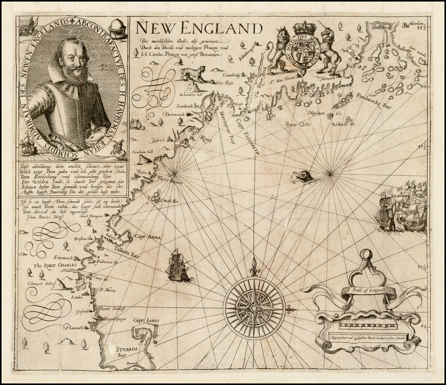 |
| 1624:01a | [1624]: ALEXANDER, William state 1 [Untitled Map Of New England And Maritime Canada]From: Alexander An Encouragement To Colonies …, London, 1624From: Alexander The Mapp And Description Of New-England; Together With A Discourse Of Plantation And Colonies …, London, 1630 (This volume was composed of existing printed stock of the map and text, with a new title-page). | Copper engraving, 250 x 340mm.Burden: North America, 208 (pl.208); Schwartz & Ehrenberg: Mapping of America, pl.54.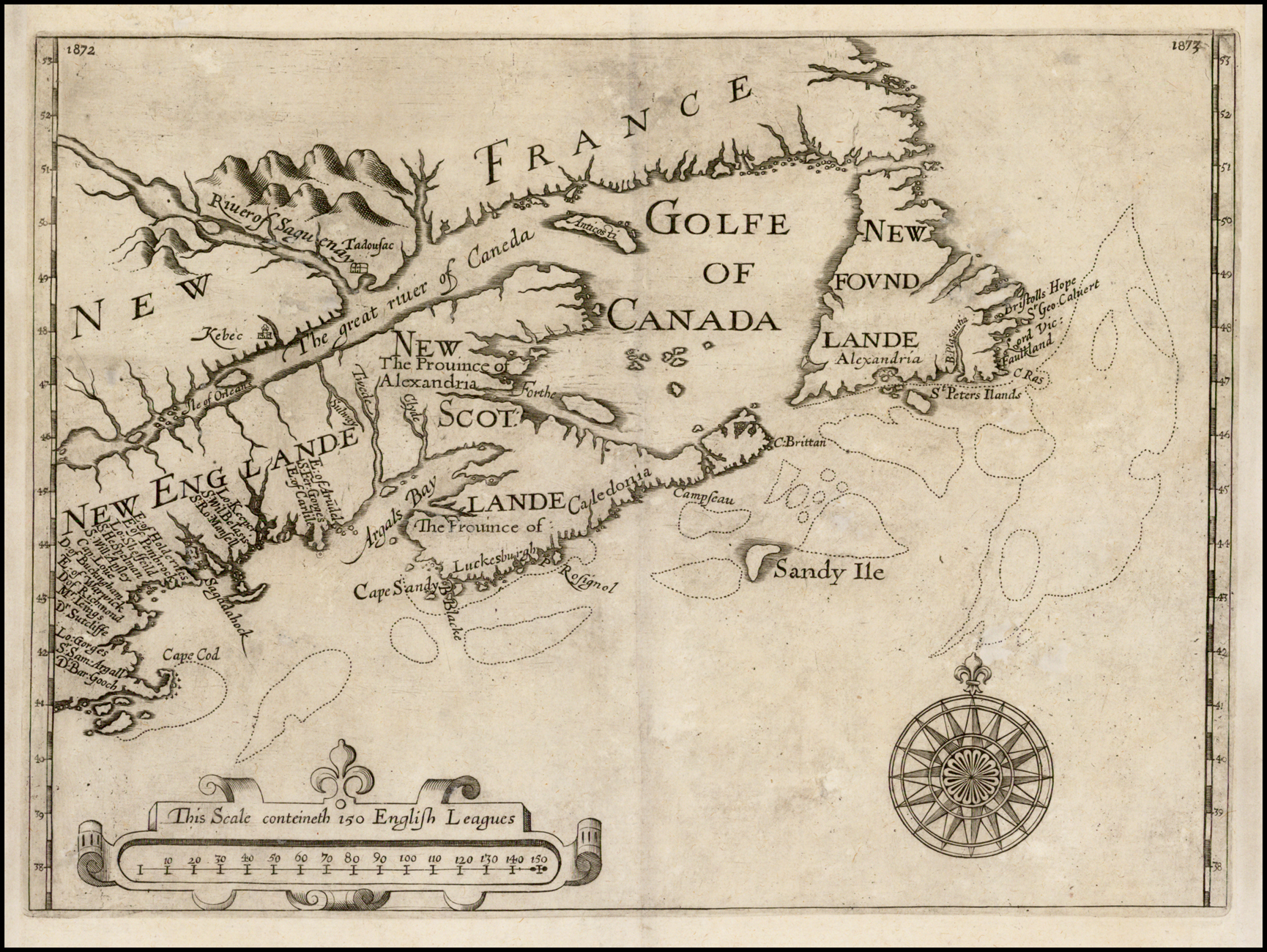 |
| 1624:01b | [1624]: ALEXANDER, William state 2 [Untitled Map Of New England and Maritime Canada] 1872 [1a] 1873 [5a]From: Samuel Purchas Hakluytus Posthumus Or Purchas His Pilgrimes …, London, 1625 | State 2: with the addition of the page numbers, for the binder, for inclusion in Purchas’ collection of travel accounts. Burden: North America, 208: state 2. |