While Moll’s county atlases and large maps – most particularly those prepared for “The World Described” – are relatively well described in modern carto-bibliographies, Moll was also a prolific contributor of individual maps used to illustrate books of travel, siege accounts, campaign histories and the like, and also serial publications such as the “Atlas Geographus”, and these maps have not received the attention they deserve. Particular difficulties are faced establishing when and in what publication a particular plate or group of plates originated, in what other publications they appeared, and when they were superseded or otherwise replaced.
One of the scarcest of Moll’s atlas publications is his “Twenty Four New And Accurate Maps Of The Several Parts Of Europe”, which was published, without date, buy a group of booksellers: John Nicholson, Benjamin Barker, Charles King, Benjamin Tooke, Henry Clements, Richard Parker and Ralph Smith.
The date of publication would seem to be fixed by an advertisement in the “London Gazette”, for July 10th – 14th 1706:
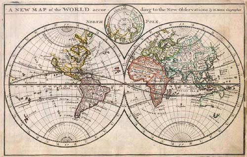
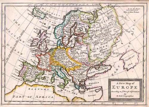
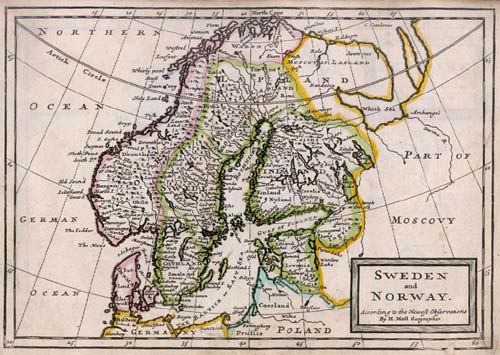
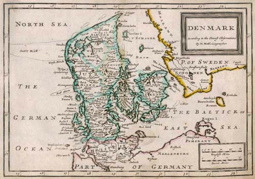
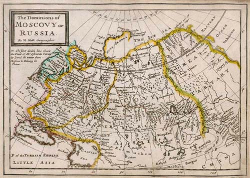
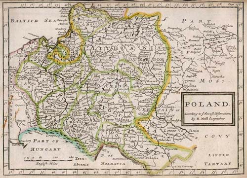
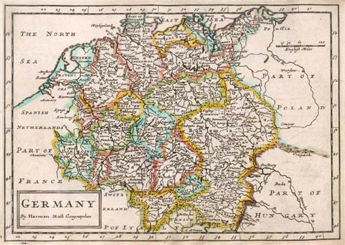
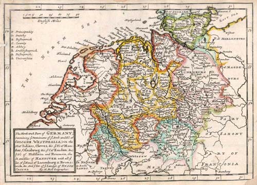
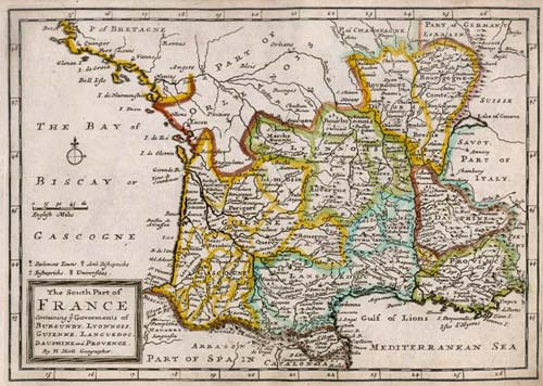
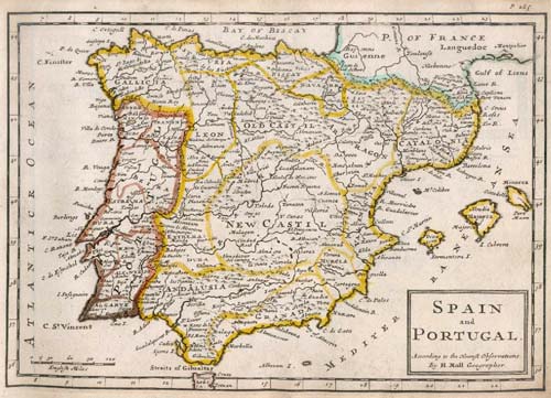
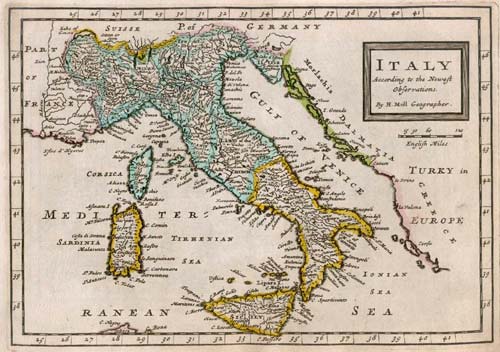
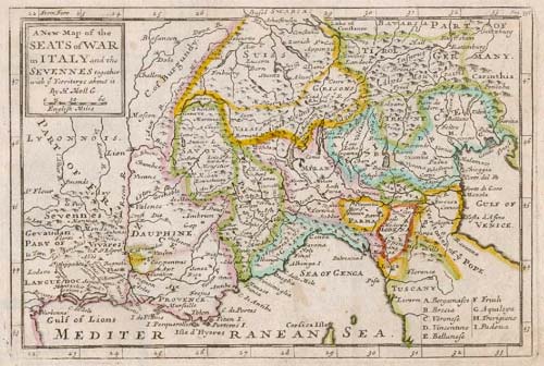
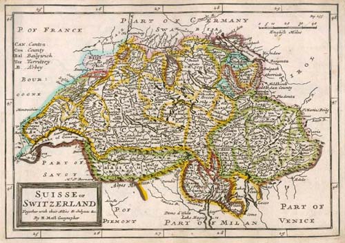
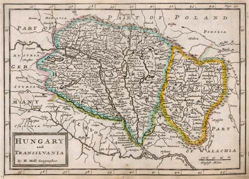
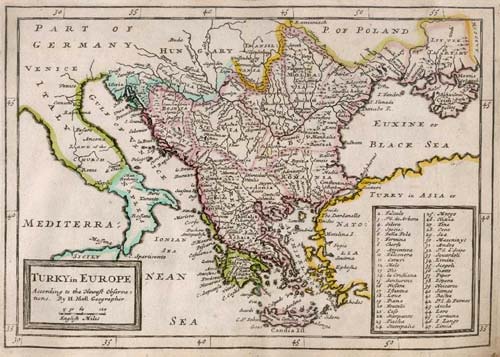
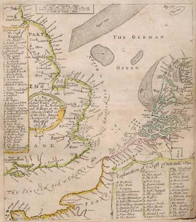
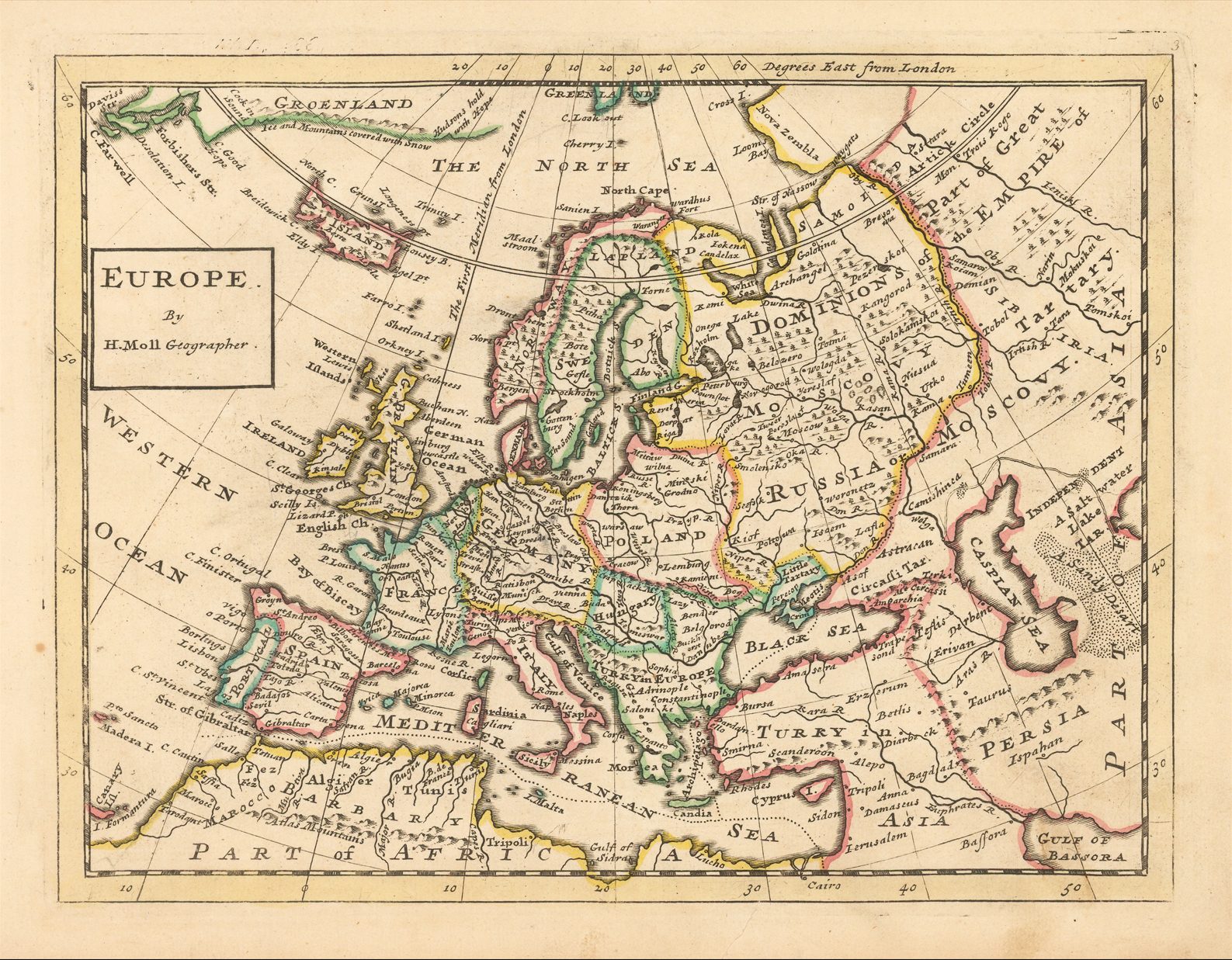
“Newly publish’d, 24 Accurate Maps of the several Parts of Europe: Done according to the newest Observations, by Herm. Moll, Geographer; viz. 1. The World, 2. Europe. 3. Sweden, &c. 4. Denmark. 5. Muscovy. 6. Poland, 7. Germany in general. 8. 9. 10. 11. and 12. The several Parts of Germany. 13. Holland, &c. 14. Flanders. 15. France. 16. and 17. North and South Part of France. 18. Spain and Portugal. 19. Italy, with Naples, &c. 20. Lombardy, as joining to Provence, Dauphine, &c. 21. Switzerland. 22. Hungary. 23. Turkey in Europe. 24. The English Chanel Coast, &c. Useful to all that read the Publick Prints, or have Mr. Eachard’s Newsman’s Interpreter. Sold by J. Nicholson in Little Britain, and by most Booksellers and Mapsellers. Price 5 s. colour’d 6s” (Tyacke: London Map-Sellers, no. 363).
However, Donald Hodson records a second advertisement, from the Daily Courant, for July 8th 1707, which reads:
“This day is publish’d, twenty four new and accurate maps of the several parts of Europe [list of maps]. All (except the last), new done … By Herman Moll … Sold by J. Nicholson …, Benj. Baker and Charles King …, Benj. Tooke …, Hen. Clements …, R. Parker and Ralph Smith … Price 5s.”
While “This day” is a notoriously unreliable statement, this date does at least accord with the advertisement contained at the end of the letterpress title-page of this book, for Moll’s map of Great Britain, which was advertised as “This day is publish’d” in the Daily Courant for August 11th 1707.
As yet unexplained is the origin of the page numbers found on some of the maps, but a search of publications by Moll and the other publishers concerned is underway to solve this mystery, aided by existing and ongoing research into newspaper advertisements of the period, which are bringing to light many books containing maps.
Some of the maps were included in [David Jones] “A Compleat History Of Europe: Or, A View Of The Affairs Thereof, Civil And Military, From The Year, 1600 To The Treaty Of Nimeguen, To Perfect The Last Century. Containing All The Public And Secret Transactions Therein; The Rise And Progress Of Our Civil War; The Wars And Revolutions Of France, Germany, Sweden, Poland Hungary, Portugal, &c. Intermix’d With Great Variety Of Original Papers, Letters, Memorials, Treaties, &c. Several Of Which Are Not To Be Met With Elsewhere …” published as an annual from 1705 onwards, although whether this is their origin is still uncertain.
The maps are later found in Moll’s “Atlas Geographus”, 1711-1717, several with the page numbers altered, or inserted. The British Library’s example of the “Maps Of The Several Parts Of Europe” was evidently issued about 1711, as the appropriate page numbers for the “Atlas Geographus” appear on three maps: the World, Russia and Poland.
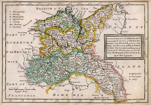
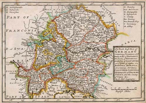
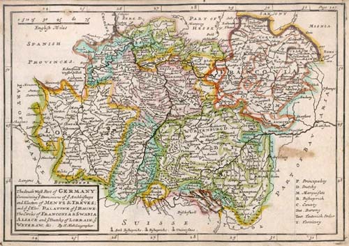
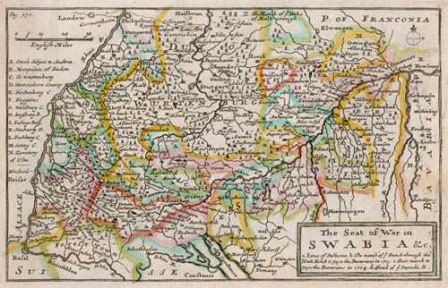
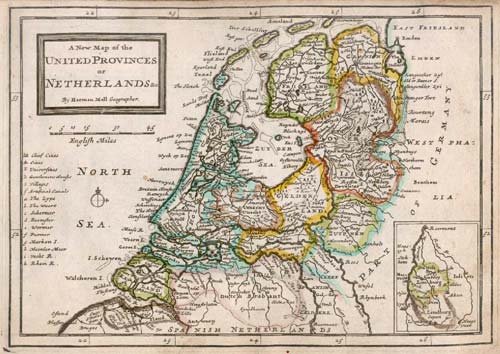
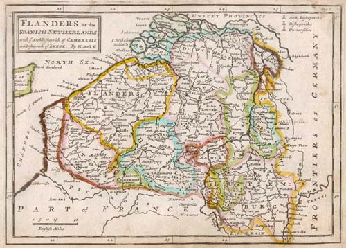
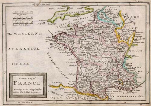
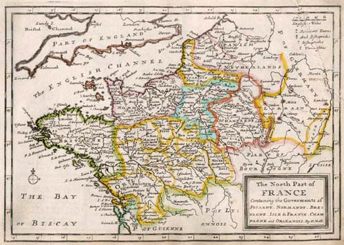
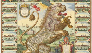
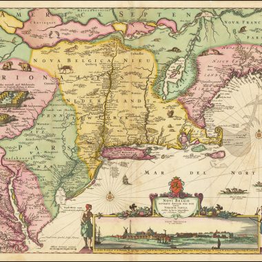
| Twenty four New and Accurate / MAPS / Of the several Parts of EUROPE; / (VIZ.) [list in 2 columns] 1. The WORLD in General. 2. EUROPE in Particular. 3. SWEDEN and NORWAY. 4. DENMARK. 5. MUSCOVY, or RUSSIA. 6. POLAND. 7. GERMANY in General. 8. The North-East Part of Germany, containing the Dutchies / of Mecklenburg and Pomerania, Brandenburgh, Saxony, Silesia, / the Marquisate of Lusatia, &c. 9. The North-West Part of Germany, containing Cologne, West- / phalia, Juliers, Cleeves, Munster, Osnaburgh, Holstein, Bremen, / Hanover, Lunenburgh and Brunswick, Hesse-Cassel, &c. 10. The South-East Part of Germany, viz. Bavaria, Newburgh, / Saltzburgh, Bohemia, Moravia, Austria, Styria, Carinthia, / Carniola, Brixen, Trent, Tirol, &c. 11. The South-West Part of Germany, viz. Mentz and Treeves, / Palatinate of the Rhine, Circles of Franconia, Swabia and / Alsace, Lorain the Weteraw, &c. // [vertical rule] // 12. Swabia and Franconia, with the Duke of Marlborough’s / March to Hochstet, &c. 13. The UNITED-PROVINCES, or Netherlands. 14. FLANDERS, or the Spanish Netherlands; with the / Bishopricks of Cambray and Liege. 15. FRANCE in General. 16. The North Part of France, viz. Picardy, Normandy, Bre- / tagne, Isle of France, Champagne and Orleanois. 17. The South Part of France, viz. Burgundy, Lyonois, Guienne, / Languedoc, Dauphine and Provence. 18. SPAIN and PORTUGAL. 19. ITALY in General, with Naples, the Isle of Sicily, &c. 20. LOMBARDY, with Dauphine, Provence, the Cevennes, &c. 21. The SWISSE CANTONS, or Switzerland; with the / Grisons Country, &c. 22. HUNGARY, Transilvania, &c. 23. TURKEY in Europe. 24. The English Channel; with the Coasts of England, France / and Holland. / [rule] / All (except the last) New done, according to the latest Observations, by HERMAN MOLL, Geographer: / And very Useful to all that read the Publick Papers, or that have Mr. Echard’s Gazetteer. / [rule] / SOLD by J. Nicholson at the King’s-Arms in Little-Britain, Benj. Barker and Charles King in Westminster-Hall , Benj. Tooke at the Temple-Gate, / Fleet-Street, Hen. Clements at the Half-Moon in St. Paul’s Church-Yard, R. Parker and Ralph Smith under the Royal-Exchange, and most Map-sellers. / Price 5 s. Coloured 6 s. Where may be had the Newest Map of Great-Britain, by H. Moll. Price 1s. 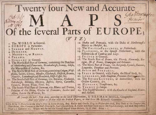 |