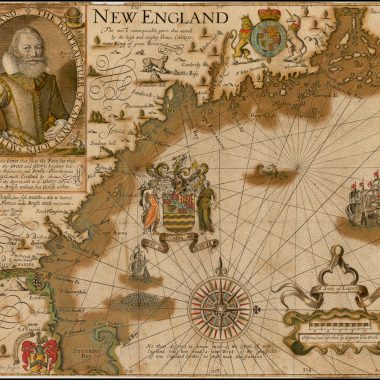
| 1630 | [1630]: GERRITSZ., Hessel NOVA ANGLIA, / NOVVM BELGIVM / ET VIRGINIA. [1b][Inset] ‘Bermuda majori mole expressa’ 82 x 88 [5d; 4d/e-5d/e] From: Laet Beschrijvinghe Van West Indien …, Leiden, 1630 | Copper engraving, 282 x 359 PM: 285 x 363mm. McCorckle: New England, 630.1; Burden: Mapping Of North America, 231 (pl.231); Cumming: Southeast In Early Maps, 35. |
| 1634:01a | 1634: WOOD William state 1 The South part of Nevv-England, as it is / Planted this yeare, 1634. [1a, ob – 5a, ob]From: Wood Nevv Englands Prospect. A True, Lively And Experimentall Description Of That Part Of America, Commonly Called Nevv England …, London, 1634 | Woodcut, with the title printed from letterpress, 180 x 300mm. McCorckle: New England, 634.1 (ill); Burden: Mapping Of North America, 239 (pl.239). |
| 1634:01b | 1634-1635: WOOD William state 2 The South part of Nevv-England, as it is / Planted this yeare, 1635. [1a, ob – 5a, ob]From: Wood Nevv Englands Prospect. A True, Lively And Experimentall Description Of That Part Of America, Commonly Called Nevv England …, London, 1635 | State 2: now dated 1635 in the title. cf. McCorckle: New England, 634.1; Burden: Mapping Of North America, 239: state 2. |
| 1634:01c | 1634-1639: WOOD William state 3 The South part of Nevv-England, as it is / Planted this yeare, 1639. [1a, ob – 5a, ob]From: Wood Nevv Englands Prospect. A True, Lively And Experimentall Description Of That Part Of America, Commonly Called Nevv England …, London, 1639 | State 3: now dated 1639 in the title. cf. McCorckle: New England, 634.1; Burden: Mapping Of North America, 239: state 3. |
| 1634:02 | [1634]: BLAEU, Willem Jansz. NOVA / BELGICA / ET / ANGLIA / NOVA. [5c]Inset: ‘Modus muniendi apud Mahikanenses.’ [4a] From: Blaeu Novus Atlas, Das Ist Abbildung Und Beschreibung Von Allen Länden Des Erdreichs …, Amsterdam, 1634 | 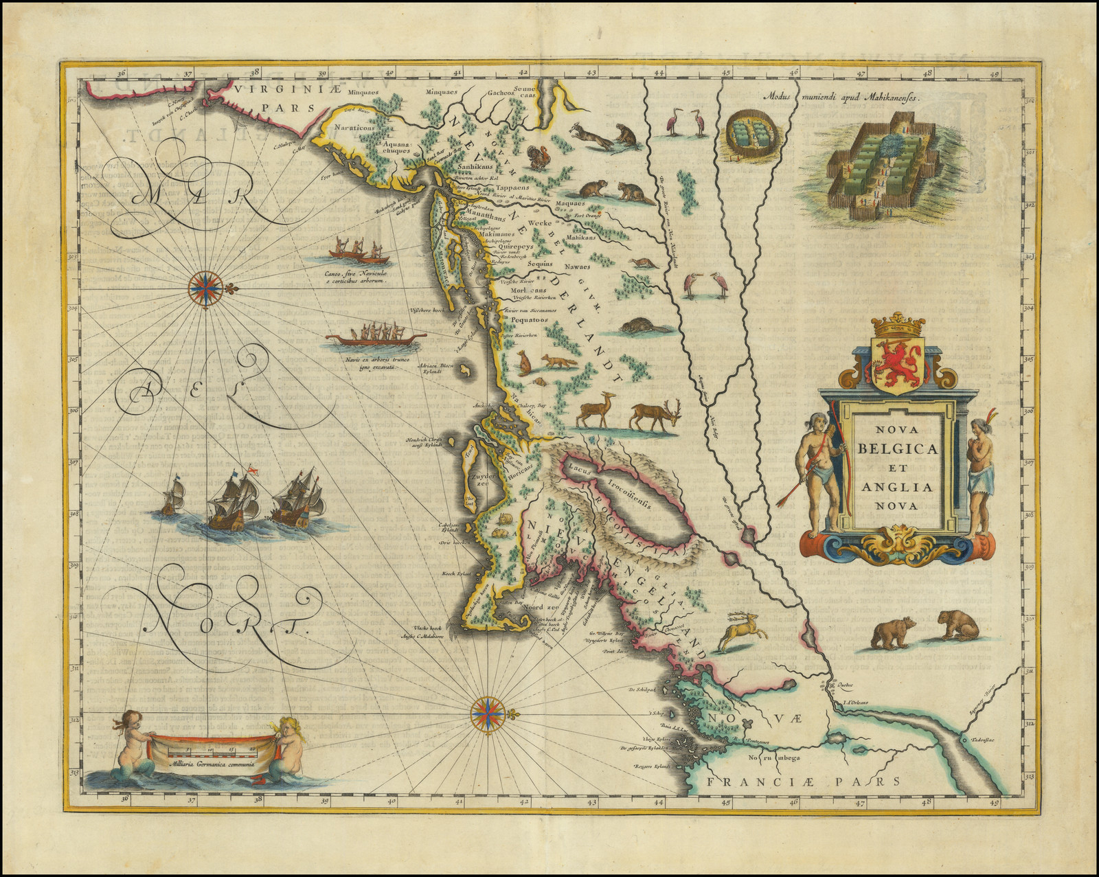 Copper engraving, 385 x 505mm. McCorckle: New England, 635.1 (ill); Burden: Mapping Of North America, 243 (pl.243). |
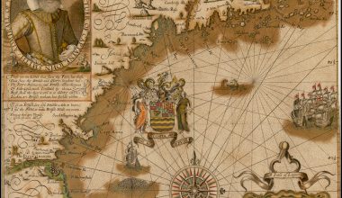
| 1636:01a | [1636]: JANSSONIUS, Johannes (II) state 1 NOVA ANGLIA / NOVVM BELGIVM / et / VIRGINIA. [1b] Amstelodami / Johannes Janssonius / Excudit. [5e]From: Hendrick Hondius Atlas Or A Geographicke Description …, Amsterdam, 1636 | Copper engraving, 390 x 505mm. McCorckle: New England, 636.2 (ill); Burden: Mapping Of North America, 247 (pl.247); Koeman/Krogt, map 9310:1A.1: state 1. |
| 1636:01b | [1636] – [1645]: JANSSONIUS, Johannes (II) state 2 NOVA / BELGICA / ET / ANGLIA / NOVA. [1b] Amstelodami / Johannes Janssonius / Excudit. [5e]From: Janssonius Novus Atlas …, Amsterdam, 1645 | Copper engraving, 387 x 504 PM: 390 x 508mm. State 2: with the title and title cartouche re-engraved. The cartouche is now a rectangular architectural design. Additional names have been added in the map. Drawings of the two bears, two storks, and an Indian village have also been added. McCorckle: New England, 636.2, notes (ill: detail of the central portion); Burden: Mapping Of North America 247: state 2; Cumming: Southeast In Early Maps, 43 (pl.25); Fite & Freeman, 39(ill); Koeman/Krogt, map 9310:1A.2: state 2; |
| 1636:01c | [1636] – [ca. 1715]: JANSSONIUS, Johannes (II) state 3 NOVA / BELGICA / ET / ANGLIA / NOVA. [1b] Amstelodami / Apud G. VALK et P. SCHENK. [5e]From: [Gerard Valk & Petrus Schenk Sr., Composite Atlases, Amsterdam, ca. 1715] | State 3: with the joint imprint of Valk and Schenk substituted. A graticule has been superimposed on the map, and boundaries inserted. McCorckle: New England, 636.2, notes; Burden: Mapping Of North America, 247: state 3; Cumming: Southeast In Early Maps, 43. |
| 1651:01 | [1651]: HARTGERS, Joost Virginia / Nieu Neder-landt, / Nieu Engelandt. [2b]From: Hartgers Beschrijvinghe Van Virginia, Nieuw Nederlandt, Nieuw Engelandt …, Amsterdam, 1651 Inset: ‘de Bermudas Eÿlanden na de grote afdeling.’ [4d; 4d/e – 5d/e] | Copper engraving, 170 x 265mm. McCorckle: New England, 651.1; Burden: Mapping Of North America, 304 (pl.304). |
| 1651:02a | [1651 ca.]: JANSSONIUS, Johannes (II) state 1 BELGII NOVI, / ANGLIÆ NOVÆ, ET PARTIS / VIRGINIÆ / Novissima Delineatio. [4e]Johannes Janssonius II, Separate publication, Amsterdam, [ca. 1651] From: Janssonius Atlantis Majoris …, Amsterdam, 1657 | Copper engraving, 445 x 520mm. Campbell: Jansson-Visscher Sequence, 1 (pl.144); McCorckle: New England, 650.1 (ill); Burden: Mapping Of North America, 305 (pl.304). |
| 1651:02b | [1651] – [ca.1663]: JANSSONIUS, Johannes (II) state 2 BELGII NOVI, / ANGLIÆ NOVÆ, ET PARTIS / VIRGINIÆ / Novissima Delineatio. [4e] NOBILISSIMO / Amplissimoque Viro, / D.no GVALTHERO de RAET, / Equiti Baronetto, Curiæ Hol= / landiæ, Zelandiæ Frisiæque / Senatori dignissimo, / D.D.D. Ioannes Ianssonius. [3e]Johannes Janssonius II, Separate publication, Amsterdam, [ca. 1663] From: Janssonius Atlas Contractus …, Amsterdam, 1666 | State 2: with the addition of the dedication. Campbell: Jansson-Visscher Sequence, 2 (pl.145); McCorckle: New England, 650.1, notes; Burden: Mapping Of North America, 305: state 2. |
| 1651:02c | [1651] – [ca.1715]: JANSSONIUS, Johannes (II) state 3 BELGII NOVI, / ANGLIÆ NOVÆ, ET PARTIS / VIRGINIÆ / Novissima Delineatio. / Prostant Amstelaedami apud / Petrum Schenk, et Gerardum Valk / C.P. [4e] NOBILISSIMO / Amplissimoque Viro, / D.no GVALTHERO de RAET, / Equiti Baronetto, Curiæ Hol= / landiæ, Zelandiæ Frisiæque / Senatori dignissimo, / D.D.D. Petrum Schenk. [3e]From: [Gerard Valk & Petrus Schenk Sr. Composite Atlases, Amsterdam, ca. 1715] | Campbell, Jansson-Visscher Sequence, 3 (pl.136); McCorckle: New England, 650.1, notes; Burden: Mapping Of North America, 305: state 3. |
| 1655:01a | [1655 ca.]: VISSCHER, Nicolaas Jansz. state 1 NOVI BELGII / NOVÆQUE ANGLIÆ NEC NON / PARTIS / VIRGINIÆ TABULA / multis in locis emendata a / Nicolao Joannis Visscher. [4d]Nicolaas Jansz. Visscher Separate publication, [Amsterdam, ca. 1655] Insets: ‘NIEUW AMSTERDAM / op t’Eylant Manhattans.’ [4d; 2d/e – 4d/e] ‘Modus muniendi apud Mahikanenses / Maniere van Woonplaetsen ofte Doorpen der Mahicans / ende andre Natien haer geburen.’ [1b] [Untitled Circular Indian Village] | Copper engraving, 465 x 555mm. Campbell, Jansson-Visscher Sequence, 4; McCorckle: New England, 655.1; Burden: Mapping Of North America, 315 (pl.315); Stokes: American Historical Prints, pl.6; Deak, no.38. Location: NN, Stokes Collection; [attached to a copy of a report on the Delaware River, dated January 1656] |
| 1655:01b | [1655] – [ca. 1655]: VISSCHER, Nicolaas Jansz. state 2 NOVI BELGII / NOVÆQUE ANGLIÆ NEC NON / PARTIS / VIRGINIÆ TABULA / multis in locis emendata a / Nicolao Joannis Visscher. [4d]Nicolaas Jansz. Visscher Separate publication, [Amsterdam, ca. 1655] | State 2: ‘t Fort Kasimier’ has been inserted [2d], on the left bank of the Delaware River, above Delware Bay, added in response to the Dutch capture of the fort in 1655. Campbell: Jansson-Visscher Sequence, 5 (pl.147); McCorckle: New England, 655.1 (ill); Burden: Mapping Of North America, 315: state 2. |
| 1655:01c | [1655] – [ca. 1685]: VISSCHER, Nicolaas Jansz. state 3 NOVI BELGII / NOVÆQUE ANGLIÆ NEC NON / PARTIS / VIRGINIÆ TABULA / multis in locis emendata / per Nicolaum Visscher. [4d]From [Nicolaas Visscher Composite Atlases, Amsterdam, ca. 1685] | 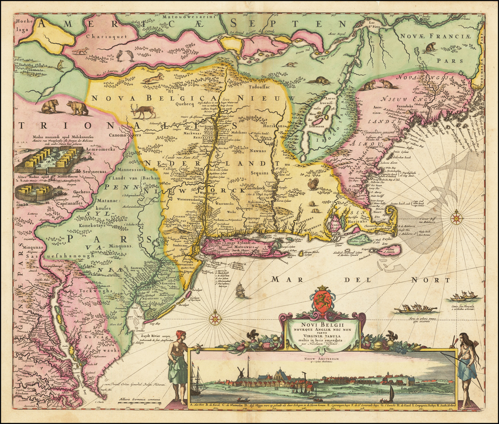 State 3: The imprint in the title has been revised. Within the map there are numbers of additions: ‘NIEW JORCK’ province is named [2c-3c]. Long Island is now named ‘t Lange Eylandt alias / landt Matouwacs nu / Jorck Shire’ [3d]. A key, lettered a-f, has been added off Long Island, relating to New York and long Island [3d]. In New Jersey, the following names are inserted: ‘Gomoenipa’, ‘Engelsche Plantagie’, ‘Quakers hoeck’, ‘Graef Hendric’, ‘Cahoos ofte Waterval’, and others [2d]. ‘PENN- / SYL- / VA- / NIA’ is named [2c] and ‘Philadelphia’ has been inserted, with a miniature ground plan [2d]. ‘Schoonberg’ is named, immediately above Philadelphia [2d]. Fort Kasimier is now named ‘Nieu Amstel of’t ‘t Fort Kasimier’ [2d]. ‘Zuydt Rivier eertyts / toehoorende de Stat Amsterdam’ is added [2d]. A new note has been added above the lower inset of the Indian village: ‘Alter Modus apud Minnessincos / Ander Manier der Minnessincksche / Dorpen. [1c] Campbell, Jansson-Visscher Sequence, 5a; Burden: Mapping Of North America, 315: state 3; |
| 1655:01d | [1655] – [ca. 1683]: VISSCHER, Nicolaas Jansz. state 4 NOVI BELGII / NOVÆQUE ANGLIÆ NEC NON / PARTIS / VIRGINIÆ TABULA / multis in locis emendata / per Nicolaum Visscher. [4d] cum Privil: Ordin: General: Belgii Foederati. [2d]From [Nicolaas Visscher Composite Atlases, Amsterdam, ca. 1683] | State 4: with the addition of the privilege. Campbell: Jansson-Visscher Sequence, 6 (pl.148); Burden: Mapping Of North America, 315: state 4; |
| 1655:01e | [1655] – [ca. 1727]: VISSCHER, Nicolaas Jansz. state 5 NOVI BELGII / NOVÆQUE ANGLIÆ NEC NON / PARTIS / VIRGINIÆ TABULA / multis in locis emendata per Nicolaum Visscher. / Nunc apud Petr. Schenk Iun. [4d] cum Privil. Ordin. General. Belgii Foederati. [x2]From [Petrus Schenk Jr. Composite Atlases, Amsterdam, ca. 1727] | State 5: with the imprint of Petrus Schenk Jr. inserted in the title, presumably shortly after his acquisition of the plate, circa 1726. Campbell: Jansson-Visscher Sequence, 7 (pl.149); McCorckle: New England, 655.1, notes; Burden: Mapping Of North America, 315: state 5; |