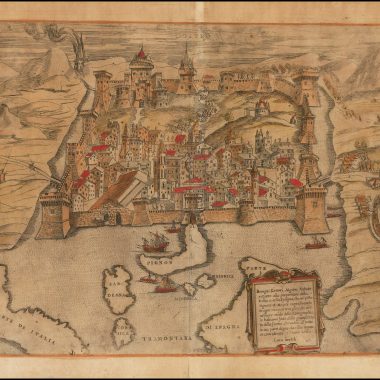
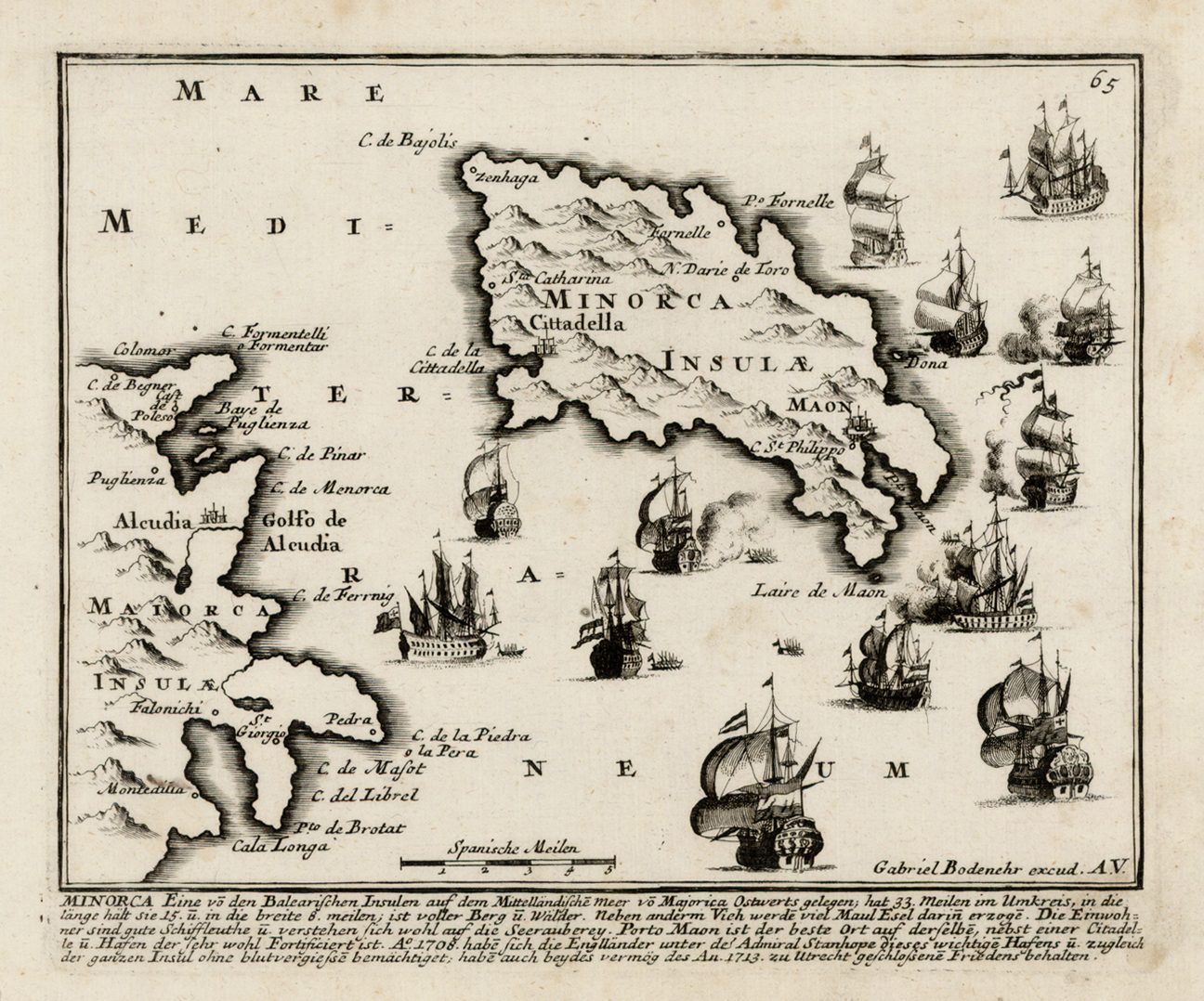
Mahon Harbour is one of the largest natural harbours in the world, a deep inlet extending some three and a half miles inland. Its importance had been recognised since classical times, when the island was occupied by the Carthaginian general Mago, brother of Hannibal, who gave his name to the town and harbour, then Rome, who referred to the town as ‘Port Magonis’.
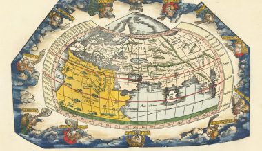
The earliest separate printed maps of the Balearic Islands appear in Benedetto Bordone’s Libro Di Benedetto Bordone Nel Qual Si Ragiona De Tutte L’Isole Del Mondo, published in 1528, with Minorca and Majorca together on one map, and Ibiza and Formentera on another. Geographically, however, the maps were very schematic, with the only place name on Minorca being ‘porto mao’.
Other maps of Minorca and Maiorca were issued by the members of the “Lafreri-school” of mapmakers, in the 1560’s and 1570’s, and by Tomasso Porcacchi, in his L’Isole Piv Famose Del Mondo.
The first general map of the three islands together was issued by Gerard de Jode, in his Speculum Orbis Terrarum (Antwerp, 1578). Interestingly, de Jode’s delineation was copied in a very rare map by the Cologne author Johannes Metellus (or Matal), issued in the Insularum Orbis Aliquot Insvlarvm, (Cologne, 1601). In some ways, the map is deservedly rare, for the engraver has reversed the islands in the copying process, so that Minorca ostensibly lies to the west of Majorca, and Ibiza to the east.
While the quality of maps of the islands improved during the seventeenth century, it was the wars of the eighteenth century that saw heightened interest in detailed mapping of Mahon Harbour, and the fort constructed at the harbour mouth, Fort San Felipe or, as it was known to the British, St. Philip’s Castle.
In the main, it was the British, possessors of the island for much of this period, that were responsible for the mapping, although cartographers of other nations took an interest as circumstances dictated. Certainly, the island had an eventful history in the eighteenth century.
The British first gained control of Minorca in 1708, during the War of the Spanish Succession, and held the island until 1756, when it was captured by the French, during the Seven Years War. As part of the territorial settlement ending that war, in 1762, the island was restored to the British, and retained until 1782, when a joint Franco-Spanish expedition forced the capitulation of St. Philip’s Castle, as one part of the European theatre of the American War of Independence. However, the British re-captured the island in 1788, before finally ceding the island to Spain in 1802.
The chief impetus for the mapping of the island during the eighteenth century was military, and a large number of maps were published throughout Europe, but particularly in England, France and Germany to depict both the fortifications prefatory to attack, and to record events of the sieges.
St. Philip’s Castle also attracted a great deal of attention, and a series of plans of the castle’s defences were prepared in 1756, at a time when they were in considerable disrepair. The British subsequently spent a great deal of money fortifying the castle, and extending the network of underground tunnels and defences, making the most expensive capital project undertaken by the British Army until the 20th Century.
After the loss of the island to the French in 1756 the map was re-engraved by Kilian, with a new title and text, altered coastlines, roads and more fortifications. Note however the remains of the plate number top right.
The epic siege of 1756 gave rise to one of the most famous lines of literature. The Fort was defended by William, Baron Blakeney, lieutenant-governor of Minorca, with a force of about 5,000 soldiers and workmen, against a force of about 15,000 French troops. The defenders were handicapped by the poor state of the defences, but held on determinedly for relief. A fleet assembled for that purpose arrived off the island, and fought an indecisive battle with the French fleet on May 20th. The British commander, however, determined to retire and left the garrison to its fate. A second fleet arrived only to find that the garrison had surrendered after an epic siege of 71 days.
When he returned to England, the eighty-four year old Blakeney was greeted as a national hero. By contrast, Vice Admiral John Byng was executed by firing-squad for his failure. As Voltaire noted at the time, every once in a while the British had to execute an admiral “pour encourager les autres”.
| 1. | [ca. 1700]: LEA, Philip PORT MAHON. [2a-4a, in border]Inset: [‘I. Minorca.’] IB: 45 x 59 [4d/e – 5d/e]From: Lea ‘Hydrographia Universalis’, London [ca. 1700] | IB: 181 x 153 B: 130 x 156 [scale] ‘A League’ – [1] (34mm) [2b] |
| 2. | 1702: THORNTON, John: Mediterranean A New & Correct Chart of the / MEDITERRANEAN SEA / From y.e Streights mo.th to Constantinople / Taken from the Originall done by the / French / With Particular Harbours at Large. / [rule] / By Iohn Thornton Hydrographer at / the Sign of England Scotland and Ireland in the / Minories London / 1702. [1c] I: Blount Sculp: [5e]Inset: ‘PORT MAHON’ [scale] ‘A Scale of one Mile’ – [1] (60mm) IB: 130 x 210 (orientated with south at the top) [1a] ‘LIVORNO / als / LEGHORN.’ [scale] ‘A Scale of 2 Miles’ – ‘2’ (51mm) IB: 125 x 202 [4a] [Untitled Chart Of ‘SEA OF MAMORA / GULF OF CONSTANTINOPLE’ [scale] ‘A Scale of 10 Leagues’ – ’10’ (42mm) IB: 121 x 224 [5a] ‘THE GULF / OF / SMYRNA / By Cap.t Charles Wild’ [scale] ’15 Miles’ – ’15’ IB: 28 x 175 [5b] ‘CADIZ’ [scale] ‘A Scale of 8 Leagues’ – ‘8’ (65mm) IB: 165 x 114mm [1a] ‘ALGIER / By S.r John Narborough’ [scale] [not given] IB: 152 x 200 [2e] ‘TRIPOLI’ [scale] [not given] IB: 107 x 123mmFrom: Thornton ‘Atlas Maritimus’, London [ca. 1702] | 435 x 1005 PM W: 445 x – [scale] ‘English and French Leagues 20 in a Degree’ – ’60’ (84mm) / ‘Duytsch Milen 15 in een Graet’ – ’45’ (84mm) / ‘Leagueas de Spania 17 1/2 un Grada’ – ’52 1/2′ (84mm) [4e] |
| 3. | [1703]: BROWNE, Christopher: Spain: State 1 THE WAR IN PORTUGALL / AND / SPAIN / with the Harbours of THE GROYNE, VIGO & BAYONA, PORTO, / LISBON & S.T UBES, CADIZ, &c. / AND / A CHART from ENGLAND to the STREIGHTS. / [rule] / Sold by Christopher Browne at the Globe near the West / End of S.t Pauls Church London [2d]Inset: ‘THE GROYNE’ [Corunna] 123 x 116 [1a] ‘A GENERAL CHART from ENGLAND to SPAIN’ 119 x 115 [1b] ‘VIGO and BAYONNA’ [key: a-d] 69 x 115 [1c] ‘PORTO’ 41 x 115 [1c] ‘LISBON and S.T UBES’ 105 x 115 [1d] ‘THE HARBOUR OF CADIZ’ 133 x 115 [1d/e]From: Browne Separate publication, London, [1703] | 601 x 514 PM: – x – [scale] ‘English Leagues’ – ‘120’ (123mm) / ‘Spanish Leagues’ – ’35’ (122mm) [2e] State 1: referred to in the Term Cataloguesfor Michaelmas Term, 1703 – Licen sed December; the dvertisement seems to call only for the western half of the Iberian peninsula, with the map extending eastwards to include Madrid; |
| 4. | [1703] BROWNE, Christopher: Spain: State 1, Issue 2 [1704] THE WAR IN PORTUGALL / AND / SPAIN / with the Harbours of THE GROYNE, VIGO & BAYONA, PORTO, / LISBON & S.T UBES, CADIZ, &c. / AND / A CHART from ENGLAND to the STREIGHTS. / [rule] / Sold by Christopher Browne at the Globe near the West / End of S.t Pauls Church London [2d] ‘THE GROYNE’ [Corunna] 123 x 116 [1a] ‘A GENERAL CHART from ENGLAND to SPAIN’ 119 x 115 [1b] ‘VIGO and BAYONNA’ [key: a-d] 69 x 115 [1c] ‘PORTO’ 41 x 115 [1c] ‘LISBON and S.T UBES’ 105 x 115 [1d] ‘THE HARBOUR OF CADIZ’ 133 x 115 [1d/e] ‘BARCELONA’ 76 x 118 [5a] PORT MAON / In the Island of Minorca’ 105 x 115 [5b] ‘ALICANTE’ 69 x 115 [5c] ‘CARTAGENA’ 76 x 115 [5c] ‘ALMEIRA’ 81 x 115 [5d] ‘GIBRALTER’ 90 x 115 [5d/e] [‘BARCELONA’] 108 x 153 [4d] ‘BADAJOS.’ 100 x 94 [4e]From: Browne Separate publication, London, [1704] | 601 x 993 2 sheets joined [scale] ‘English Leagues’ – ‘120’ (123mm) / ‘Spanish Leagues’ – ’35’ (122mm) [2e] State 1, issue 2: a second sheet has been added, extending the map to cover the entire peninsula; this sheets bears Harris’ name as engraver.Advertised in the London Gazette for July 13th – 17th 1704/ |
| 5. | [1703] BROWNE, Christopher: Spain: State 2 [ca. 1714] THE WAR IN PORTUGALL / AND / SPAIN / with the Harbours of THE GROYNE, VIGO & BAYONA, PORTO, / LISBON & S.T UBES, CADIZ, &c. / AND / A CHART from ENGLAND to the STREIGHTS. / [rule] / Sold by Tho: Bowles Print and Mapseller in S.t Pauls Church Yard / next to the Chapter House London. [2d] I. Harris delin. et sculp. [5e]Inset: ‘THE GROYNE’ [Corunna] 123 x 116 [1a] ‘A GENERAL CHART from ENGLAND to SPAIN’ 119 x 115 [1b] ‘VIGO and BAYONNA’ [key: a-d] 69 x 115 [1c] ‘PORTO’ 41 x 115 [1c] ‘LISBON and S.T UBES’ 105 x 115 [1d] ‘THE HARBOUR OF CADIZ’ 133 x 115 [1d/e] ‘BARCELONA’ 76 x 118 [5a] PORT MAON / In the Island of Minorca’ 105 x 115 [5b] ‘ALICANTE’ 69 x 115 [5c] ‘CARTAGENA’ 76 x 115 [5c] ‘ALMEIRA’ 81 x 115 [5d] ‘GIBRALTER’ 90 x 115 [5d/e] [‘BARCELONA’] 108 x 153 [4d] ‘BADAJOS.’ 100 x 94 [4e]Thomas (II) Bowles Separate publication, London, [ca. 1714] | 601 x 993 2 sheets joined[scale] ‘English Leagues’ – ‘120’ (123mm) / ‘Spanish Leagues’ – ’35’ (122mm) [2e] ‘Explanation. / [list of symbols].’ [2d]State 3: with the imprint revised; the ‘Explanation’ has been added, and the compass points added in the border: ‘WEST’ [1c, in border], ‘NORTH’ [3a, in border] ‘SOUTH’ [3e, in border] and ‘EAST’ [5c, in border] ‘THE BAY OF BISCAY’ is named; a large number of additions have been made within the map, most noticeably the addition of roads across the whole map. Within ‘ASTURIAS’ the regions ‘ASTURIA / OVIEDO’ and ‘ASTURIAS / SANTII’ are named. |
| 6. | [1703] MOUNT & PAGE: Mediterranean A / GENERALL / CHART / of the / MEDITERRANEAN SEA / Sold by Rich.d Mount and Tho: Page at the / Postern on Great Tower Hill London. [L: 2a]Inset: ‘Port Maon upon y.e Island MINORCA’ [orientated with north-west at the left] [scale] ‘A Mile’ – ‘1’ (87mm) IB: 102 x 167 [L: 2d; 1d/e – 2d/e] ‘THE BAY OF TUNIS’ [scale] ‘A Scale of Leagues’ – ‘4’ (52mm) IB: W: 112 x 240 [L: 2d/e – 4d/e] ‘THE GOLFE OF / SMYRNA.’ [scale] ‘English Leagues’ – ‘8’ (88mm) IB: 135 x 180 [R: 4a/b – 5a/b] ‘THE BAY OF SCANDERONE’ [scale] ”Leagues’ – ‘5’ (45mm) IB: 93 x 150 [R: 4b/c – 5b/c]From: ‘The English Pilot … Mediterranean’, London, 1703 | L: 454 x 578 PM: – x – R: 453 x 579 PM: – x 582 [scale] ‘English and French Leagues 20 in a Degree’ – ‘100’ (148mm) [L: 2b] ‘Islands in the / Adriatick Sea. / [rule] / a-I, k-s.’ // ‘A Table of the Names of some of the small Islands in the Archipelago. / 1-22 / 23-44 / 45-46.’ [2a/b – 4a/b]Outside the upper border of the left sheet is the engraved note ‘joyn here’, on an engraved line extending south through the eastern tip of Malta; on the eastern sheet, on a line down the inside border is the engraved note ‘Cut here’; |
| 7. | [1703 ?] MOUNT & PAGE: State 1 A / LARGE CHART / of / PORT MAON / on the / ISLAND MINORK / in the / MEDITTERANEAN. [2a]From: [?] ‘English Pilot … Mediterranean’, London, 1703 | 432 x 537 PM: 440 x 538 [scale] ‘A Scale of 8 Furlongs or one English Mile’ – ‘8’ (170mm) [2d-4d] Clearly a Mount and Page plate, it was presumably intended for the 1703 edition of the ‘English Pilot’, for the Mediterranean, although it is not found in the British Library example. It is found in one example of the ‘The English Pilot. … Describing The … Mediterranean Sea …’, published by John Seller Sr. in 1677, but is apparently a later addition. |
| 8. | [1703 ?] MOUNT & PAGE: State 2 [1716] A / LARGE CHART / of / PORT MAON / on the / ISLAND MINORCA / on the Mediterranean. [4d]BARCELONA / BY IOHN GAUDY / Variation 11 Degrees West.ly / Anno 1705. [2b]THE HARBOUR OF MALTA. [4a]From: ‘The English Pilot … Mediterranean’, London, 1716 | W: 317 x 535 B: 434 x 535 PM: 441 x 542 [scale] ‘A Scale of 8 Furlongs or one English Mile’ – ‘8’ (170mm) [2d-4d] State 2 of the plate: the title for the Mahon Harbour section has been erased and moved to the lower right hand corner. Two additional charts have been added in the upper part of the plate: of Barcelona, dated 1705, and Valletta Harbour. |
| 9. | [1703 ?] MOUNT & PAGE: State 3 [1736] A / LARGE CHART / of / PORT MAON / on the / ISLAND MINORCA / on the Mediterranean. [4d]BARCELONA / BY IOHN GAUDY / Variation 11 Degrees West.ly. [2b]THE HARBOUR OF MALTA. [4a]From: ‘The English Pilot … Mediterranean’, London, 1736 | W: 317 x 538 B: 434 x 538 PM: 440 x 542 [scale] ‘A Scale of 8 Furlongs or one English Mile’ – ‘8’ (170mm) [2d-4d] State 3 of the plate: the date has been erased from the title of the chart of Barcelona. |
| 10. | [1712 ca. ?]: NICHOLLS, Sutton: Gibraltar: State 1 Several Prospects of the Rock, Town, Castle, Fortifications, & Bay of GIBRALTAR, also a Plan of y.e same w.th y.e Approaches of the Spaniards in y.e last War, & y.e addition of the / New Works, Likewise a Map of y.e Streights of Gibraltar w.th y.e adjacent Parts of Spain; a Chart of y.e Streights w.th y.e Soundings of y.e Bay, a Map of y.e Island of Majorca & a Chart of Port Mahon w.th y.e Soundings of that Bay. [1a, ob -5a, ob] Nicholls sculp. [5e, ob] A CHART / of the / STREIGHTS / of / GIBRALTAR / with the / Soundings &c. [3c; 1a-3a] Inset: ‘A Map of the STREIGHTS of GIBRALTAR / and the Adjacent Parts of Spain. [1b] A SOUTH PROSPECT OF THE ROCK OF GIBRALTAR. [3a/b – 5a/b] THE NORTH.ern PROSPECT of the BAY, TOWN and ROCK of GIBRALTAR [1b/c – 3b/c] A PROSPECT of the Town and Rock of GIBRALTAR from the BAY. [3b/c – 5b/c] An Exact / PLAN / of the / TOWN, CASTLE, MOLE / And BAY of / GIBRALTAR / Likewise the Approaches of y.e Spaniards / in the Last War. / [rule] / EXPLANATION of the / References in this Plan. / A-I, K-T, V-Y, a-c. [1d-1e] THE ISLAND OF MAJORCA. 5d] PORT MAHON / In the Island of MINORCA. [5e]From: Nicholls Separate publication, London, [ca. 1712] | B: 463 x 570 Top: 228 x 570 Bottom: 235 x 570 Gibraltar Chart: 111 x 282 Inset: 86 x 98; South Prospect: 111 x 280 North Prospect: — x — Prospect: 110 x 280 Gibraltar Plan: 235 x 350 Majorca: 68 x 108 Port Mahon: 80 x 108 |
| 11. | [1712 ca. ?]: NICHOLLS, Sutton: Gibraltar: State 2 [ca. 1728] Several Prospects of the Rock, Town, Castle, Fortifications, & Bay of GIBRALTAR, also a Plan of y.e same w.th y.e Approaches of the Spaniards in y.e last War, & y.e addition of the / New Works, Likewise a Map of y.e Streights of Gibraltar w.th y.e adjacent Parts of Spain; a Chart of y.e Streights w.th y.e Soundings of y.e Bay, a Map of y.e Island of Majorca & a Chart of Port Mahon w.th y.e Soundings of that Bay. [1a, ob -5a, ob] Nicholls sculp. [5e, ob] ‘A CHART / of the / STREIGHTS / of / GIBRALTAR / with the / Soundings &c.’ [scale] ‘Scale of Leagues’ – ‘5’ (50mm) 111 x 282 [3c; 1a-3a] Inset: ‘A Map of the STREIGHTS of GIBRALTAR / and the Adjacent Parts of Spain.’ 78 x 100 with title: 86 x 100 [1b] ‘A SOUTH PROSPECT OF THE ROCK OF GIBRALTAR.’ IB: 110 x 282 [3a/b – 5a/b] ‘THE NORTH.ern PROSPECT of the BAY, TOWN and ROCK of GIBRALTAR.’ IB: 101 x 283 [1b/c – 3b/c] ‘A PROSPECT of the Town and Rock of GIBRALTAR from the BAY.’ IB: 110 x 280 [3b/c – 5b/c] ‘An Exact / PLAN / of the / TOWN, CASTLE, MOLE / And BAY of / GIBRALTAR / Likewise the Approaches of y.e Spaniards / in the Last War. / [rule] / EXPLANATION of the / References in this Plan. / A-I, K-T, V-Y, a-c.’ [scale] ‘Scale of Feet’ – ‘500’ (41mm) 232 x 350 W: 297 x 350 [1d-1e] ‘THE ISLAND OF MAJORCA.’ [scale] ‘Miles’ – ’20’ (20mm) 68 x 109 [5d] ‘PORT MAHON / In the Island of MINORCA.’ [scale] ‘Half a Mile’ – ‘1/2’ (41mm) 80 x 108 [5e]From: Thomas (II) Bowles Separate publication, London, [ca. 1728] | B: 463 x 571 PM: 487 x 584 Top: 228 x 570 B: 235 x 570 State 2: with the imprint of Thomas and John Bowles, the latter’s address datable to the period after 1728. |
| 12. | [1712 ca. ?]: NICHOLLS, Sutton: Gibraltar: State 3 [ca. 1733] Several Prospects of the Rock, Town, Castle, Fortifications, & Bay of GIBRALTAR, also a Plan of y.e same w.th y.e Approaches of the Spaniards in y.e last War, & y.e addition of the / New Works, Likewise a Map of y.e Streights of Gibraltar w.th y.e adjacent Parts of Spain; a Chart of y.e Streights w.th y.e Soundings of y.e Bay, a Map of y.e Island of Majorca & a Chart of Port Mahon w.th y.e Soundings of that Bay. [1a, ob -5a, ob] Nicholls sculp. [5e, ob] ‘A CHART / of the / STREIGHTS / of / GIBRALTAR / with the / Soundings &c.’ [scale] ‘Scale of Leagues’ – ‘5’ (50mm) 111 x 282 [3c; 1a-3a] Inset: ‘A Map of the STREIGHTS of GIBRALTAR / and the Adjacent Parts of Spain.’ 78 x 100 with title: 86 x 100 [1b] ‘A SOUTH PROSPECT OF THE ROCK OF GIBRALTAR.’ IB: 110 x 282 [3a/b – 5a/b] ‘THE NORTH.ern PROSPECT of the BAY, TOWN and ROCK of GIBRALTAR.’ IB: 101 x 283 [1b/c – 3b/c] ‘A PROSPECT of the Town and Rock of GIBRALTAR from the BAY.’ IB: 110 x 280 [3b/c – 5b/c] ‘An Exact / PLAN / of the / TOWN, CASTLE, MOLE / And BAY of / GIBRALTAR / Likewise the Approaches of y.e Spaniards / in the Last War. / [rule] / EXPLANATION of the / References in this Plan. / A-I, K-T, V-Y, a-c.’ [scale] ‘Scale of Feet’ – ‘500’ (41mm) 232 x 350 W: 297 x 350 [1d-1e] ‘THE ISLAND OF MAJORCA.’ [scale] ‘Miles’ – ’20’ (20mm) 68 x 109 [5d] ‘PORT MAHON / In the Island of MINORCA.’ [scale] ‘Half a Mile’ – ‘1/2’ (41mm) 80 x 108 [5e]From: Thomas (II) Bowles Separate publication, London, [ca. 1733] | B: 463 x 570 Top: 228 x 570 Bottom: 235 x 570 State 3: with the address of John Bowles, in the imprint, revised. |
| 13. | [1712 ca. ?]: NICHOLLS, Sutton: Gibraltar: State 4 [ca. 1780] [Untitled Composite Sheet Of Images Of Gibraltar] ‘A CHART / of the / STREIGHTS / of / GIBRALTAR / with the / Soundings &c.’ 111 x 281 [3c; 1a-3a] Inset: ‘A Map of the STREIGHTS of GIBRALTAR / and the Adjacent Parts of Spain.’ 77 x 99 with title: 85 x 99 [1b] ‘A SOUTH PROSPECT OF THE ROCK OF GIBRALTAR.’ 111 x 280 [3a/b – 5a/b] ‘THE NORTH.ern PROSPECT of the BAY, TOWN and ROCK of GIBRALTAR.’ 101 x 280 [1b/c – 3b/c] ‘A PROSPECT of the Town and Rock of GIBRALTAR from the BAY.’ 110 x 271 [3b/c – 5b/c] ‘An Exact / PLAN / of the / TOWN, CASTLE, MOLE / And BAY of / GIBRALTAR / Likewise the Approaches of y.e Spaniards / in the Last War. / [rule] / EXPLANATION of the / References in this Plan. / A-I, K-T, V-Y, a-c. 227 x 350 Widest: 227 x 555 [1d-1e] ‘THE ISLAND OF MAJORCA.’ 68 x 99 [5d] ‘PORT MAHON / In the Island of MINORCA.’ 77 x 100 [5e]From: Wilkinson Separate publication, London, [ca. 1780] | B/ PM: 455 x 560 State 4: the plate has been cut down inside the existing engraved border, removing the general title and imprint of Thomas and John Bowles, and has the imprint of Robert Wilkinson added. On the right hand side, the cutting process has removed several words from the key to the prospect of the town, which have not been replaced. Otherwise, the sheet seems completely unchanged, with the exception of the ‘South Prospect.’ In the South Prospect, the key has been replaced with text ‘In Feb 1726/7 y.e Spaniards / made another attempt / upon this Fortress; but af- / ter 4 Months, firing at a / distance a Cessation of / Arms released them / from the danger of carrying their / approaches to or near the / Town.’ [5b] As a result, the following additions appear in the Prospect: ‘Algezira or / Old Gibraltar’, ‘Back of the / New Mole’, ‘Spanish Coast’ ‘The South end of the Rock’, removing the relevant numbers; the Moorish Wall is not named. The Mahon inset has been cut down with the loss of ‘… T[ower]’ from ‘A Watch Tower’, and the lower border moved up to just below’S. Phillips Castle’. There does not appear to be any additions within the map. |
| 14. | [1716]: FER, Nicolas de : state 1 LE PORT ET LA VILLE / DE MAHON / le Bourg et le Fort / de S.t Philippe / Dans l’Isle de Minorque l’vne / des Isles de la Mer Mediterranée / sur les Côtes d’Espagne Par de / Fer Geographe de sa Majesté / Catholique. [5a]From: De Fer ‘Atlas Curieux’ Paris [1714-1716] | 222 x 324 PM: 221 x 331 [scale] ‘Echelle. / de trois cent Toises’ – ‘300’ (50mm) [5e] |
| 15. | [1716]: FER, Nicolas de : state 2 [1717 or later] LE PORT ET LA VILLE / DE MAHON / le Bourg et le Fort / de S.t Philippe / Dans l’Isle de Minorque l’vne / des Isles de la Mer Mediterranée / sur les Côtes d’Espagne Par de / Fer Geographe de sa Majesté / Catholique. [5a] 70 [5a, ob]From: De Fer ‘Atlas Curieux’ Paris [1716-1717] | 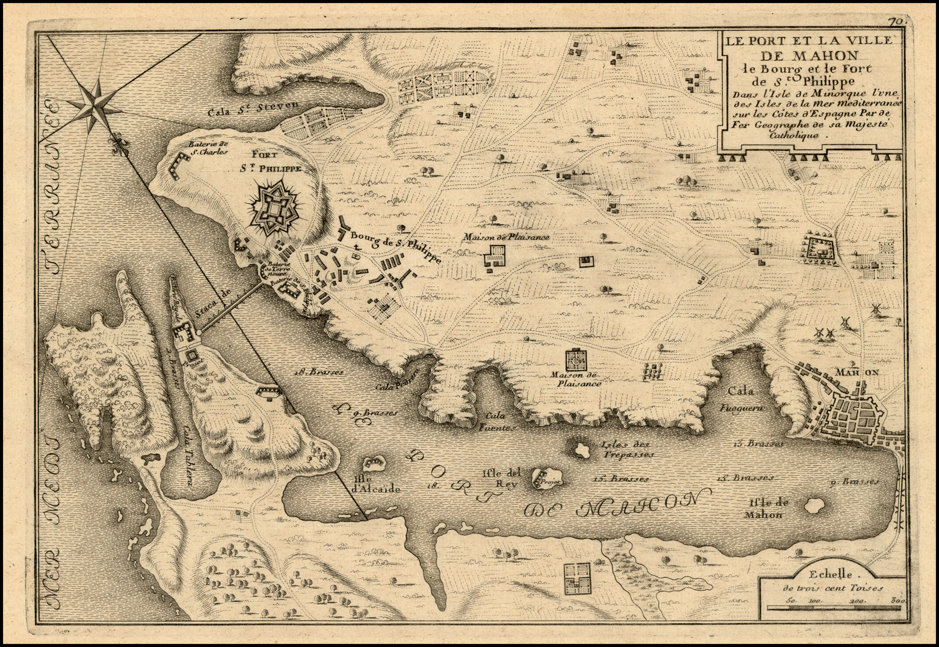 222 x 326 PM: 222 x 333 [scale] ‘Echelle. / de trois cent Toises’ – ‘300’ (50mm) [5e] State 2: with the addition of the plate number outside the upper border. |
| 16. | [1720]: SCHENK, Petrus: St. Philip’s Castle: State 1 PLAN / de la Fortification Fait par les Anglois sur la Fort / S.T PHILIPPO / Situé a Lembouchire / du / PORT de MAHON / dans l’Isle de Minorque. / By Petrus Schenk in de Warmoes Straat / t’hoekje van de Vis-steeg in N. Visschers / Atlas tot Amsterdam. / [scale bar]. [2a]From: Petrus Schenk Separate publication, Amsterdam, [ca. 1720] | 459 x 543 PM: 470 x 557 [scale] – ‘600 Englise’ (60mm) [2b] |
| 17. | [1720]: SCHENK, Petrus: St. Philip’s Castle: State 2 [ca. 1756] PLAN / de la Fortification Fait par les Anglois sur la Fort / S.T PHILIPPO / Situé a Lembouchire / du / PORT de MAHON / dans l’Isle de Minorque. / By Petrus Schenk in de Kalver Straat / tussen de Gaper en Spaarpots steeg in N. Vischers Atlas tot Amsterdam. / [scale bar]. [2a]From: Petrus Schenk Separate publication, Amsterdam, [ca. 1756] | 455 x 535 PM: 467 x 548 [key] ‘RENVOYS. / 1-20. [4b][scale]- ‘600 Englise’ (60mm) [2b] State 2: in the title, Schenk’s address has been revised. The key has been inserted, and linked to the map. The fortifications of the Castle has been heavily re-engraved, rremoving the outermost bastions [2d, 2c and 4b]. The ‘Nouvelle Ville / de S.t / Philippe’ has been inserted [2b-4b], and a new outer defensive wall added. The area thus enclosed has had the field pattern erased, and replaced by grass tufts. The ‘Redoute de Marlborough’ is added [2d]. Within the castle itself ‘Le nouvel / Hopital’ appears [2d], with two Magazine above and to the left. In the first state a building was show as part of the wall to the right of the right hand magazine. This building has been removed, so the wall is now continuous. ‘Fort Philippet’ is so named [4d]. In the harbour, the plain compass rose is added, with rhumb lines emanating from it. |
| 18. | [1728] CUTLER, Nathaniel [Untitled Sheet containing 10 Harbour Charts, including] A / Draught of the / HABOUR, / of / PORT MAHON. [4c] [scale] ‘Four Furlongs or / Half an English Mile’ – ‘4’ (55mm) IB: 351 x 176 [4b/e – 5b/e] S. Parker Sculp.t [5e, ob] 28 [5e, orb]From: Daniel Defoe & Nathaniel Cutler ‘Atlas Maritimus’ London, 1728 | 455 x 570 PM: 475 x 593 |
| 19. | [1734]: KEULEN, Gerard van NIEUWE AFTEEKENING VAN DE RIVIER OF PORTO MAHON AEN DE Z.O. HOEK VAN HET EYLAND MINORCA IN DE MIDDELANDSCHE ZEE. [1a, ob – 5a, ob] Te Amsterdam by GERARD van KEULEN aan de Nieuwen Brug met Previlegie. [2a-4a]Inset: ‘DE STADT MAON of MAHON of MINORCA.’ IB: 109 x 157 [5e]From: Keulen ‘Nieuwe Groote Lichtende Zee-Fakkel …’ Amsterdam, 1734 | 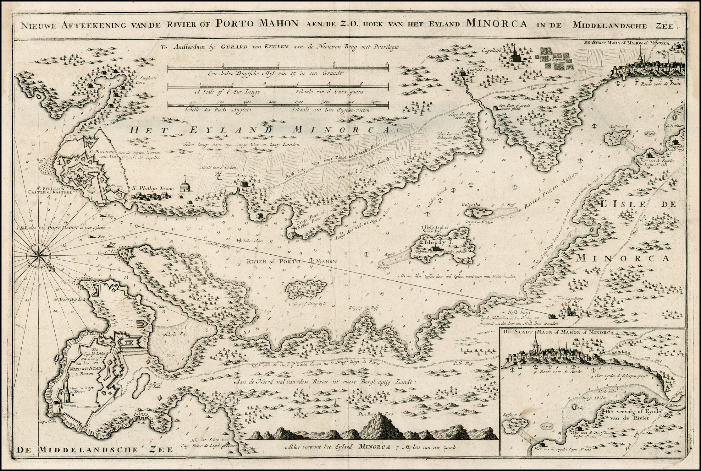 IB: 356 x 573 B: 381 x 577 PM: 389 x 583 [scale] ‘Een halve Duytsche Myl van 15 in een Graadt’ – ‘1/2’ (189mm) / ‘A Scale of 6 Eur Longs Schaale van 6 Vurs gaans’ – [7] (189mm) / ‘Echelle des Pieds Anglois Schaale van 4000 Engelse vorten.’ – [4250] (189mm) [2b-4b] |
| 20. | [1736]: MOUNT & PAGE: Balearics The COAST of / SPAIN / from Cape S.t Martin to Cape S.t Sebastian / with the ISLANDS of / MAJORCA MINORCA & YVICA / by MICHELOT Hydrographer & Pilot / Royal of the Galley & BREMOND Hydrographer / to the King & City of Marseilles. [1a] [scale bars] / Sold by William Mount & Thomas Page / Tower Hill. [5b]Inset: ‘A PLAN OF PORT MAHON IN THE ISLAND OF MINORCA.’ [4d-4b] [scale] A Scale of 100 Toises’ – ‘1000’ (77mm) [5e] 265 x 93 [4b/e – 5b/e]From: ‘The English Pilot … Mediterranean’, London, 1736 | 404 x 522 PM: 410 x 517[scale] ‘English and French Leagues 20 to a Degree’ – ’20’ / ‘Mediterranean Miles 75 to a Degree’ – ’70’ |
| 21. | 1738: SENEX, John: Mediterranean: State 1 A New Map, or Chart of / The MEDITERRANEAN SEA / made from the draughts of the Pilots of Marseilles and / Corrected by the best Astronomical Observations / By Order of / M.GR LE COMTE DE MAUREPAS / 1738 / To which is annex’d / A Draught of the Straits mouth with the Bays of Cadis / Gibralter and Malaga, the Ports of Legorne, Naples, Mahon, / Smyrna, Thessalonica, Scandaroon, and Alexandria with / the Course of the Nile from thence to Grand Cairo. / Advertisement. / The Places where Latitude and Longitude have been de / termined by Observation are thus * marked. / Those whose Latitude alone thus [symbol] and / Those whose Latitude has been accurately observed by able / Navigators are marked thus [symbol]. / The first Meridian is that of London distant from that of / Paris 2.d-25.E. from that of the Isle de Fer 19.d-0′ W. & from Teneriff 17.d W. / N.B. Sold by Iohn Senex over against S.t Dunstans Church in / Fleetstreet. price 2.s 6.d. / 1. Where may be had a New Map, or Chart in Mercators Projection of / the Western or Atlantick Ocean, with part of Europe, Africa, / and America. price 1.s 6.d / 2. A new Chart of the Coast &c. of New England as Survey’d by / Cap.t Cyprian Southack. price 1.s 6.d / 3. The Zodiac, containing all the Stars in the Way of the Moon / and Planets, with D.r Halley’s directions for finding y.e Longitude / at Sea. price 6.s. / 4. The two Hemispheres, on which are incerted all the Stars in / the Britanic Catalogue &c. with Bayer’s letters of refference, Pro= / =jected on the Plane of the Equator. / 5. ___ The same Projected on the Plane of the Ecliptic. price 8.s / each pair. / 6. The newest and best Globes of 3, 9, 12, 17 and 28 inches diamet.r / containing more on them, than on any others, that are not made by / Iohn Senex F.R.S. [1: 1a]Inset: ‘The Harbour of / Port Mahon.’ [scale] ‘Half an English Mile’ – ‘1/2’ (27mm) 87 x 180 [1: 3a] ‘A Correct Map of the / STRAITS of GIBRALTAR / with the Coast of Spain from / Cadis to Malaga.’ [scale] ‘A Scale of Miles 60 to a Degree’ (37mm) 141 x 229 [1: 1e-3e] ‘The Road of / LEGORNE.’ 140 x 230 [1; 3e-4e] ‘Cape Vinsizat’ [coastal profile] 141 x 23 [2: 1d-1e] ‘The Bay of / Naples.’ 144 x 153 [2: 5a – 3: 1a] ‘THE BAY OF / SMYRNA’ 144 x 134 [3: 2a-3a] [‘THE GULF / OF / SCANDAROON’] 144 x 119 [3: 4a] [‘SALONICHI / BAY’] 144 x 95 [3: 5a] ‘A Draught of the / Port of Alexandria / and the River Nile to / Grand Cairo’ 176 x 172 [3: 4c]From: John Senex Separate publication, London, 1738 | 592 x 1335 Three sheets: Left: 582 x 542 Centre: 579 x 521 Right: 579 x 504 |
| 22. | 1738: SENEX, John: Mediterranean: State 2 [1775] A New Map, or Chart of / The MEDITERRANEAN SEA / made from the draughts of the Pilots of Marseilles and / Corrected by the best Astronomical Observations / By Order of / M.GR LE COMTE DE MAUREPAS / [erasure] / To which is annex’d / A Draught of the Straits mouth with the Bays of Cadis / Gibralter and Malaga, the Ports of Legorne, Naples, Mahon, / Smyrna, Thessalonica, Scandaroon, and Alexandria with / the Course of the Nile from thence to Grand Cairo. / Advertisement. / The Places where Latitude and Longitude have been de / termined by Observation are thus * marked. / Those whose Latitude alone thus [symbol] and / Those whose Latitude has been accurately observed by able / Navigators are marked thus [symbol]. / The first Meridian is that of London distant from that of / Paris 2.d-25.E. from that of the Isle de Fer 19.d-0′ W. & from Teneriff 17.d W. / London. Printed for Rob.t Sayer, & John Bennett, Map- Sea-Chart, and / Printsellers, N.o 53, in Fleet Street. / Where may be had / 1. A New West India Pilot, Illustrated with Forty Correct Charts, / and Maps, done from Actual Surveys, by Thos. Jefferys, Geo- / -grapher to the King. / 2. A Chart of the River S.t Laurance, from the Isle of Anticosti, to / the Falls of Richelieu, in 12 Sheets, with directions for Navigating / that River, Published by Command of the Lords of the Admiralty. / 3. The Zodiac, containing all the Stars in the Way of the Moon / and Planets, with D.r Halley’s directions for finding y.e Longitude / at Sea. price 6.s. / 4. The two Hemispheres, on which are incerted all the Stars in / the Britanic Catalogue &c. with Bayer’s letters of refference, Pro= / =jected on the Plane of the Equator. / 5. ___ The same Projected on the Plane of the Ecliptic. price 8.s / each pair. / 6. A Map or Chart of the Gulfs of Finland and Livonia, with their res- / -pective Ports and Harbours &c. [1: 1a]Inset: ‘The Harbour & Port of Mahon / in MINORCA.’ [scale] ‘Half an English Mile’ – ‘1/2’ (27mm) 87 x 180 [1: 3a] ‘A Correct Map of the / STRAITS of GIBRALTAR / with the Coast of Spain from / Cadis to Malaga.’ 141 x 229 [1: 1e-3e] ‘The Road of / LEGORNE.’ 140 x 230 [1; 3e-4e] ‘Cape Vinsizat’ [coastal profile] 141 x 23 [2: 1d-1e] ‘The Bay of / Naples.’ 144 x 153 [2: 5a – 3: 1a] ‘THE BAY OF / SMYRNA’ 144 x 134 [3: 2a-3a] [‘THE GULF / OF / SCANDAROON’] 144 x 119 [3: 4a] [‘SALONICHI / BAY’] 144 x 95 [3: 5a] ‘A Draught of the / Port of Alexandria / and the River Nile to / Grand Cairo’ 176 x 172 [3: 4c]From: Sayer & Bennett Separate publication, London, 1775 | 584 x 1328 State 2: within the map the names of countries or, in the case of Italy, the names of the regions have been inserted: ‘SPAIN’ [1c] ‘SPAIN’ [2b] ‘FRANCE’ [2b] ‘REPUB. OF / VENICE’ [3a] ‘FERRARA’ [3b] ‘STATE OF THE CHURCH’ [3b] ‘KINGDOM / OF . NAPLES’ [3c] ‘KINGDOM OF TRIPOLY’ [3d] ‘BARBARY’ [3e] ‘CROATIA’ [3a] ‘MACEDONIA’ [4b] ‘The Black / Sea’ [4b], ‘ASIA / MINOR’ [4c] ‘THE / HOLY / LAND’ [5d] The ‘Meridian of London’ is named, and marked, and ‘the / GULF of SEEDRA or / GREATER SYRTIS’ named. Hills have been randomly engraved within Corsica, Sardinia, Sicily, Crete, ‘ROMANIA’ and Asia Minor. The title of the Mahon Harbour inset has been re-engraved, but the chart itself is apparently unchanged. |
| 23. | 1738: TOMS, William Henry A PLAN / of / The TOWN and HARBOUR / of MAHON, S.t PHILIP’s CASTLE, / and it’s Fortifications, with a / Representation of Adm.l Haddocks’ / Squadron of Men of War / Sailing into that Harbour / in the Year 1738. [4a] August 28.1738. Publish’d according to Act of Parliament. W.H. Toms sculp. [5e, ob]From: Toms Separate publication, London, 1738 | 227 x 712 W: 249 x 714 PM: 255 x 720 [key] [text] / REFERENCES / 1-24 / 25 – 32. [1e, ob – 5e, ob] – ‘1 Mile’ (149mm) [3e, ob][text] At the South East end of the Island Minorca is the Town of Mahon, lying in the Lat.de of near 40.deg and Long.de near 5.deg West, bears from Gibraltar E.N.E. distant about 630 Miles. The whole Island was taken in Sept.r 1708 by Major General Stanhope. It’s Length is about 30 Miles and greatest Breadth about 14. The chief City is Cittadela at the North West end of it; But the Place of greatest Strength is S.t Philip’s Castle a Square Fort of Four Whole Bastions, / which thô but Small (not being above 400 Feet on each Front) Yet the many Out Works cut out of the Rock on which ’tis situate, and made by the English, renders it a Fortress of great Strength. The Harbour is one of the Safest and most commodious in the Whole Mediterranean and will contain a great number of Ships, being about 3 Miles in Length and about 1/2 a Mile in Breadth. / REFERENCES . / … [1e, ob – 5e, ob] |
| 24. | [1740]: LONDON MAGAZINE A PLAN of the TOWN and HARBOUR of MAHON, &c. [2a, ob – 4ab, ob][heading] The MONTHLY CHRONOLOGER, 1740. [5b, orb – 5d, orb] 246 [5a, orb]From: ‘The London Magazine’ Vol. I, London, 1740 | 104 x 177[scale] – [1] Mile [3e, ob] |
| 25. | [1740 ca. ]: MOUNT & PAGE: Mediterranean A NEW CHART / of the / MEDITERRANEAN SEA / Composed from the Draughts of the / Pilots of Marseilles / Corrected by Astronomical Observations: / By Order of / M.GR LE COMTE DE MAUREPAS / To which are annex’d by the Editor / A Draught of the Streights Mouth including the Bays of / Cadis Gibraltar and Malaga; also the Ports of Leghorne, / Naples, Mahon, Smyrna, Salonichi, Scandaroon and / Alexandria with the Course of the Nile from the last place / to Cairo. / Advertisement. / * The Places where Latitude and Longitude have been determined / by Observations. / [symbol] Places whose Latitude only has been determined by Astronomers. / [symbol] Places whose Latitude has been accurately Observed by able / Navigators. / The first Meridian, which in the Original passes thro’ Paris, in / this Copy is that of London, being 2.o 25.’ West of the other. / Sold by William Mount & Tho.s Page Tower-Hill. / LONDON. [1a]Inset: ‘The Harbour of / Port Mahon.’ [scale] ‘Half an English Mile’ – ‘1/2’ (26mm) IB: 87 x 178 [1: 3a] ‘A Correct Map of the / STRAITS of GIBRALTAR / with the Coast of Spain from / Cadis to Malaga.’ [scale] ‘A Scale of Miles 60 to a Degree’ (36mm) 140 x 202 [1: 1e-3e] ‘The Road of / LEGORNE.’ 140 x 229 [1; 3e-4e] ‘The Bay of / Naples.’ 142 x 149 [2: 5a – 3: 1a] ‘THE BAY OF / SMYRNA’ 142 x 133 [3: 2a-3a] [‘THE GULF / OF / SCANDAROON’] 142 x 118 [3: 4a] [‘SALONICHI / BAY’] 142 x 95 [3: 5a] ‘A Draught of the / Port of Alexandria / and the River Nile to / Grand Cairo’ 179 x 170 [3: 4c]From: Mount & Page Separate publication, London, [ca. 1740] | 570 x 1283 PM: – x 1285 3 sheets joined |
*
*
| 51. | 1756: ROCQUE, John: St. Philips Castle State 1 A Plan of / S.T PHILIPS CASTLE, / on the Island of MINORCA; / with its Fortifications, & the Entrance / of the Harbour of Port Mahon / By Jn.o Armstrong Esq.r / Surveyor General to the Hon.ble Board of Ordnance. / [double rule] / To the Most High Puissant & Noble Prince / Charles Duke of Marlborough &c, Master Gen.l of y.e Ordnance / Knight of the most Noble Order of the Garter, &c. &c. / This Plan, is most humbly Inscribed / by his Graces most Devoted & Obed.t hum.ble Serv.t / Jn:o Rocque / 1756. [2c]From: Rocque Separate publication, London, 1756 | 662 x 455 PM: – x -[key] ‘Explanation. / A-I, K-T, V-Z, &, a-f.’ [1d] [scale] ‘Feet’ – ‘2000’ (124mm) [3e] |
| 52. | 1756: ROCQUE, John: St. Philips Castle State 2 [ca.1757] A Plan of / S.T PHILIPS CASTLE, / on the Island of MINORCA; / with its Fortifications, & the Entrance / of the Harbour of Port Mahon / By Jn.o Armstrong Esq.r / Surveyor General to the Hon.ble Board of Ordnance. / [double rule] / To the Most High Puissant & Noble Prince / Charles Duke of Marlborough &c, Master Gen.l of y.e Ordnance / Knight of the most Noble Order of the Garter, &c. &c. / This Plan, is most humbly Inscribed / by his Graces most Devoted & Obed.t hum.ble Serv.t / Jn.o Rocque / 1756. [2c]From: Rocque Separate publication, London, [ca. 1757] | From: Rocque Separate publication, London, 1756662 x 453 PM: – x 478 [key] ‘Explanation. / A-I, K-T, V-Z, &, a-f.’ [1d][scale] ‘Feet’ – ‘2000’ (124mm) [3e] [text] ‘NB This Plan shew’s all the French Batterys / which were Erected during the Siege. [3d]State 2: a number of additions have been made, to show positions during the siege, including the reference to French siege positions. ‘R. Rockpine’ [2b] ‘B. Le Blanc’ with an unnamed battery to its left [4b], ‘B. Louis Cours’ [5c] ‘B. S.t André’ and ‘B. S.t Michelle [4b], in ‘S.t Philips / Town’], ‘B Le Pellouse’ ‘B. Le Blanc’ and ‘B. Dolsie’ [4b]. With the exception of ‘B. Rockpine’ and the unnamed battery, lines of fire have been engraved from these batteries to the fort. |
| 53. | 1756: ROUGE, George Louis le: St. Philips Castle PLAN / DU FORT PHILIPPE / Avec les Attaques / Levé par les Ingenieurs / depuis le Siege. / A PARIS / Chez le S.r le Rouge Ingenieur Geographe / rue des Grands Augustins. / Assiegé le 19 May 1756 et rendu le 28 / au 29 Juin / Je crois ce Plan cy tres fidel et au des= / sus de ce qui a paru jusqu’a present sur / ce Fort. / Pris 48.s. Lavé. 24.s en blanc. / Publié le 13 Aoust 1756. / A.P.D.R. [5a-5c]Inset: ‘PROFIL DES FORTS ANSTRUTHER ET D’ARGILE / pris sur leurs Capitales.’ [scale] – ‘8 Toises’ 270 x 49 [2b; 1ab- 3a/b] ‘PROFIL / du Fort de la Reine / sur la Capitale.’ [scale] – ‘8 Toises.’ 308 x 34 [2d; 1d/e – 3d/e]From: George Louis le Rouge Separate publication, Paris, 1756 | 305 x 475 PM: 323 x 490 [scale] ‘300 Toises’ (99mm) [4e-5e] |
| 54. | 1756: SAYER, Robert: St. Philip’s Castle AN EXACT PLAN / OF / S.T PHILIP’S CASTLE / BY MAHON / Sold at London / by Robert Sayer / Fleet Street / May 1756. / 1 2 3 4 Magazins a poudre / 5. 6. Casternes. [1b]From: Robert Sayer Separate publication, London, 1756 | 315 x 418[scale] ‘Toises’ – ‘300’ |
| 55. | 1756: UNIVERSAL MAGAZINE: St. Philips Castle A PLAN of St. Philip’s Castle, in the Island of Minorca. [1a, ob – 5a, ob]From: ‘Universal Magazine’, London, June 1756 | 180 x 123 [key] [A-I, K-Z, a-g] |
| 56. | [1757]: ANONYMOUS: St. Philips Castle A / PLAN / OF THE / Underground Works Of S.T PHILIP’S CASTLE. / REFERENCES, / … [1d/1e] J. Mynde sc. [4e]From: Anonymous ‘A Full Answer To An Infamous Libel’, London, 1757 | 513 x 407 PM: – x – [key] [title] / REFERENCES, / A-I, K-T, V-Z / a-I, k-t, v-z, &. [1e] [scale] ‘A Scale of Feet’ – [100] – 0 – 600 (600: 89mm) [4d] |
| 57. | [1760 ca. ?]: ANONYMOUS A DRAUGHT of the TOWN and HARBOUR of MAHON with S.T PHILIP’S FORTand its FORTIFICATION. [2e, ob – 4e, ob] Vol. 4. P. 495 [5a, ob]Inset: ‘A Particular Plan / – of the – / TOWN and FORT / of / S.t PHILIP. [2b] [scale] ‘A scale of 2 Furlongs or 1/4 of a Mile.’ [key] ‘REFERENCES. / a-i, k-l / [rule] / m-t. [5e] W: 116 x 251 [1a/b – 3a/d – 5a/b]From: [?] | 163 x 251 [scale] ‘A Scale of 4 Furlongs or half a Mile’ – ‘4’ (29mm) [5b] Apparently copied from Phinn’s map of 1756. |
| 58. | [1762]: THERBU, L: St. Philips Castle PLAN / DU / FORT S.T PHILIPPE. / [scale bar]. [1d] Dessiné par Therbu Lieutenant Ingenieur. [1e, ob] Gravé par Cöntgen Graveur de la Cour a la Université de Mayence. [5e, ob] C.P.S.C.M. [3e]From: Therbu ‘Plans De La Guerre De Sept Ans’ [ca.1762] | IB: 230 x 228 B: 356 x 235 PM: 405 x 280 [scale] ‘Echelle’ – ‘300 Toises’ (52mm) [1d] |
| 59. | 1763: ANONYMOUS A NEW / and Accurate MAP of / the Island of / MINORCA, / with the Town and / Harbour of MAHON, / S.t Philip’s Castle, & / FORTIFICATIONS. / 1763. [2c] ‘British Statue Miles 69 to a Degree’ – ‘7’ (44mm) 148 x 201 [1a/d – 5a/d] [Untitled Chart Of Mahon Harbour] [scale] ‘Scale of one Mile’ – ‘1 Mile’ (53mm) [key] ‘References to the PLAN / a-i, k / l-u, w. [2d] 87 x 201 [1d/e – 5d/e]From: John Entick ‘The General History of the Late War’ London, 1763 | 234 x 201 |
| 60. | [1763]: BELLIN, Jacques-Nicolas: state 1 PLAN DU PORT / ET VILLE / DE MAHON / Aves ses Forts / [scale bar]. [5a]From: Bellin ‘Petit Atlas François’ Paris, 1763 | 216 x 172 PM: 230 x 184[key] Explication des Lettres / A-H, J-M. [1c] [scale] ‘Echelle de 600 Toises’ – ‘ 600’ (41mm) [5b] |
| 61. | [1763]: BELLIN, Jacques-Nicolas: state 2 [1764] PLAN DU PORT / ET VILLE / DE MAHON / Aves ses Forts / [scale bar]. [5a] Tome IV. N.o 67. [5a, ob]From: Bellin ‘Petit Atlas Maritime’ Paris, 1764 | 216 x 172 PM: 230 x 184 [key] ‘Explication des Lettres / A-H, J-M. [1c] [scale] ‘Echelle de 600 Toises’ – ‘ 600’ (41mm) [5b] State 2: with the volume number inserted. |
| 62. | [1770 ca.]: [LOPEZ, Don Tomas] PLAN / DEL PUERTO / Y PLAZA DE / MAHON / Con sues fuertes. / [scale bar]. [5a] Se hallará y de el Panzacola en la libreria Copia Carrera San Gerónimo [1e, ob – 4e, ob]From: [?] | 290 x 440 [key] ‘EXPLICATION / A-H, K-M.’ [1c] [scale] ‘Escala de 600 Toises’ – ‘600’ (40mm) [5b] |
| 63. | [1779]: ROUX, Joseph Plan du Port / MAHON / sur l’Isle Minorque. [2a] Pl. 66 [5a, ob]From: Roux ‘Plans Et Rades De la Mediterranee’ 1779 | 124 x 187 PM: 138 x 207 [scale] ‘Echelle de 500 Toises’ – ‘500’ (33mm) [4e] There are a large number of different plates, varying only slightly in layout and style. |
| 64. | [1779] Roux, Joseph Plan du Port / MAHON / sur l’Isle Minorque. [2a] Pl. 10. [5a, ob]From: [?] | 127 x 193 PM: 145 x 221 [scale] ‘Echelle de 500 Toises’ – ‘500’ (35mm) [4e] |
| 65. | 1780: ASSIOTTI, Francis Aegidius: Minorca [Untitled Map Of Minorca] To the Right Hon.ble / John Earl Spencer, Viscount Althorpe, &c. &c. &c. / This General Plan of the ISLAND OF MINORCA, / From an Actual Survey taken on the Spot, / Is with the Utmost Respect humbly Inscribed by his Lordships / Most Devoted and most Obedient humble Servant / Francis Ægidius Assiotti. [5e] F.Æ. Assiotti inv.t et delin. [4e, in border] LONDON Published according to Act of Parliament 1.st Feb.y 1780, by Francis Ægidius Assiotti, late Draughtsman of the Ordnance at MINORCA. [1e -2e, in border] Sold by R. Sayer & I. Bennett Map & Printsellers, N.o 53 Fleet Street. [4e, in border]Inset: ‘CHART / of the Entrance of the / MEDITERRANEAN / Compiled from the latest Surveys.’ [1d] [scale] ‘SCALE of Marine Miles 20 to a Degree’ – ’40’ (51mm) 246 x 254 W: 289 x 287 [1d-2d] ‘PLAN of the FORTIFICATIONS of S.T PHILIPS / with the TOWN or ARRAVAL which is now in- / tirely demolished as the dotted lines shew, with the / Batterys, which the French erected at the Seige in 1756 / with the New Town built near CALA-FONT in / lieu thereof called GEORGE TOWN. [2d] [scale] ‘SCALE of 800 Feet to an Inch – ‘800’ – ‘0’ – ‘4000’ (153mm) [3e-4e] [key] ‘REFERENCE. / 1-38, [2d-2e] [note] ‘BATTERIES / erected by the / French at the Seige / in 1756. / [rule] / … [4d] 223 x 364 W: 236 x 413 [2d/e – 4d/e]From: Assiotti Separate publication, London, 1780 | 900 x 1206 W: 900 x 1222 PM: – x – [key] ‘REFERENCE / … / [rule] / EXPLANATION of the Spanish words used in the Plan / …’ [2d/e][scale]’SCALE to the ISLAND is 5280 Feet, or One Mile to an Inch’ – ‘8 Miles’ (203mm) [1e] |
| 66. | 1780: FADEN, William Jr.: St. Philips Castle A PLAN / OF / S.T PHILLIPS / CASTLE / AND FORTIFICATIONS / IN THE ISLAND OF / MINORCA. / Engrav’d by W.m Faden / 1780. / [scale bar.] / [key]. 1a, ob – 1d, ob] LONDON. / Published as the Act directs, Jan.y 1.st 1780, / by / W. Faden, corner of S.t Martins Lane, Charing Cross. [1e, ob]From: Faden Separate publication, London, 1780 | IB: 461 x 554 B: 467 x 627 P: 480 x 638 [key] ‘References. / a-i, k-v.’ [1b, ob – 1d, ob] [scale] ‘Scale of Yards’ – ‘300’ (67mm) [1b, ob] |
| 67. | 1781: CARY, John Sr.: state 1 PLAN / of the / TOWN and HARBOUR / of MAHON / with / S.T PHILIPS CASTLE / and Fortifications. [2e] J. Cary sculp. [5e, ob] Published by Jas. Macgowan & W.m Davis, Feb.y 17, 1781. [3e, ob]From: [Anonymous] ‘The Field Of Mars’ London, 1781 | 169 x 230 PM: – x 254 [key] ‘REFERENCES. / a-i, k / k-u, w.’ [3e] [scale] ‘One Mile’ – [4 units] (54mm) [2b] |
| 68. | 1781: CARY, John Sr.: state 2 PLAN / of the / TOWN and HARBOUR / of MAHON / with / S.T PHILIPS CASTLE / and Fortifications. [2e] J. Cary sculp. [5e, ob]From: [Anonymous] ‘The Field Of Mars’ London, 1801 | 169 x 230 PM: – x 254 [key] ‘REFERENCES. / a-i, k / k-u, w.’ [3e] [scale] ‘One Mile’ – [4 units] (54mm) [2b] State 2: with the publisher’s imprint erased. |
| 69. | 1781: CUMBERLEDGE, Stephen Austen THE / ISLAND / of / MINORCA / from the best / Authorities. [4b] Printed for S.A. Cumberledge, at the King’s Arms, in Pater-noster-Row, Nov.r 1, 1781. [2e, ob – 4e, ob] Inset: ‘The HARBOUR of MAHON and S.T PHILIPS CASTLE.’ [scale] ‘One Mile’ – ‘1’ (21mm) [1d] 51 x 96 [1-2d]From: ‘The Universal Magazine’ vol. 69, London, October, 1781 | 182 x 228[scale] ‘British Statute Miles 69 to a Degree’ – ‘7’ (42mm) [3e] |
| 70. | 1781: DENIS, Louis NOUVELLE CARTE / DE L’ISLE MINORQUE, / AVEC LES PLANS / DU PORT MAHON ET DU FORT S.T PHILIPPE. / PAR L. DENIS. / Géographe et Auteur du Conducteur Français; / A M.R LE DUC DE CRILLON, / Lieutenant Général des Armées de leurs Majestées, / Rois de France et d’Espagne; Grand-Croix / de l’Ordre de Charles III. &c. &c. &c. / Par son tres humble et trés obeissant serviteur BASSET. [3e] A Paris Chez Basset Rüe S.t Jacques au coin de celle des Mathurins à l’Image S.t Genevieve. On trouve un assortiments de Cartes de la guerre presente; et tient Magazins de toutes sorters de Papiers en rouleaux. [1e, ob – 4e, ob] PLAN DE LA BAYE ET DU PORT MAHON. [1a] [scale] ‘Echelle de 2000. de 60 au Degré’ – ‘2. L’ (121mm) IB W: 335 x 226 [1a/d – 2a/d] PLAN DE LA VILLE ET DU FORT S.T PHILIPPE. [2d] [key] ‘POSITION DES BATTERIES / qui ont servies au Siége du / Fort S.t Philippe, en 1756. / 1-15 / A-H / I, K-Q.’ [1d] [scale] ‘Echelle de 450 Toises’ – ‘450 T.’ (66mm) [2e] IB W: 161 x 270 [1d/e – 2d/e]CARTE D’UNE PARTIE DES CÔTES / DE LA / MER MÉDITERRANÉE. [5a] [scale] ‘Echelle de 40. Lieues Marines’ – ’40 T.’ (48mm) 146 x 318 [3a/b – 5a/b] ISLE / MINORQUE. [scale] ‘Lieues de france de 20. au Degré’ – ‘3’ (118mm) [5e] [text] ‘DESCRIPTION DE L’ISLE MINORQUE / … / Le 19. aoust 1781. M.r le Duc de Crillon fit une heureuse descente à Minorque et / s’empara de toute l’Isle excepté le Fort S.t Philippe. / INDIQUATION DES DESCENTES, ET POSITIONS DES VAISSEAUX, / POUR FAVORISER LA PRISE DE L’ISLE. / A-H / I, K-P.’ [2a-2d] W: 324 x 381 [3b/e – 5b/e]From: Paul-André Bassett Separate publication, Paris, 1781 | 478 x 690 PM: – x – |
| 71. | [1781]: FORMALEONI, Vincenzo [Untitled Prospect Of Gibraltar] [scale] ‘Scala d’un miglio’ – ‘1’ (66mm) [Untitled Map Of Mahon Harbour] [scale] ‘Scala di mezzo miglio’ – ‘1/2’ (36mm)From: [Bellin] ‘Teatro Della Guerra Marittima, E Terrestre …’ Venice, 1781 | Gibraltar IB: 98 x 304 Mahon: IB: 111 x 304 B: 226 x 308 PM: 233 x 314 |
| 72. | [1781: LOPEZ DE MACHUCHA, Tomas PLAN DEL CASTILLO DE / SAN FELIPE, / Y DE SUS CERCANIAS, / Situado en la entrada de la Ria que baña / á Puerto Mahon, en la Isla de Menorca. / Por DON TOMAS LOPEZ, Geografo de los Dominios de S.M. / Madrid 1781. / [key]. [5a, orb – 5e, orb] Se hallara en Madrid en casa de su autor calle de las Carretas N.o 21. [1e, ob – 2e, ob]From: Lopez [Untitled Atlas Of Spain And Its Possessions] [Madrid, ca. 1785] | 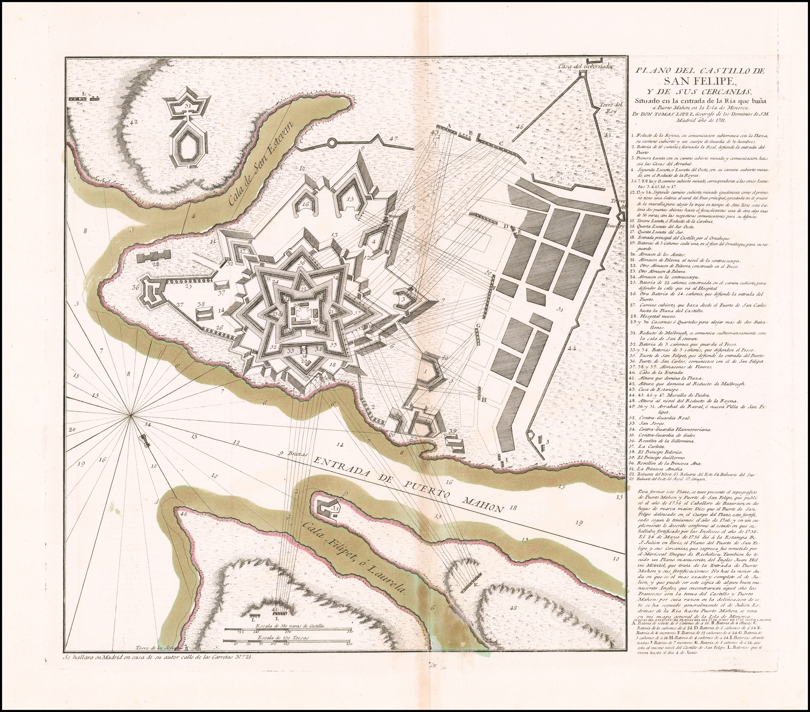 367 x 346 W: 368 x 435 PM: – x 448[key] 1-67. / [note on previous maps and plans] ATAQUES DES EXERCITO DE FRANCIA DEL DIA 27 DE JUNIO DE 1756 SEGUN LABARRE / [key] A-I, K-L. [5b, orb – 5e, orb] [scale] ‘Escala de 580 varas de Castilla’ – ‘580’ (77mm) / ”Escala de 250 Toesas’ – ‘250’ (77mm) [2e] |
| 73. | 1781: POLITICAL MAGAZINE: Minorca A CORRECT MAP of the / ISLAND OF MINORCA / with an Accurate PLAN of / FORT S.T PHILIP & its ENVIRONS, / and the French Approaches / and Batteries in 1756. [1b] Jn.o Lodge sculp. [5e, ob] London. Publish’d as the Act directs, 30.th Sept. 1781, by J. Bew, Pater Noster Row. [3e, ob] Political Mag. Sept. 1781. [5a, ob] [scale] ‘A Scale of English Miles’ – ‘8’ (84mm) [5e] Inset: [Untitled Map Of The Entrance To Mahon Harbour, with Fort S.t Philip] [1c/e – 5d] | 275 x 378 PM: 289 x – [scale] ‘A Scale of 1 Mile’ – ‘1’ (72mm) W: 145 x 281 [2e] |
| 74. | 1781: BEAURAIN, Jean de: St. Philips Castle PLAN / DU FORT SAINT PHILIPPE / DANS L’ISLE MINORQUE / DEDIEE ET PRESENTEE / AU ROI / Par le Chevalier de Beaurain. [5a] Chicot Scrip. 1781. [5e, ob] N.o 1 [5a, ob]From: Beaurain Separate publication, Paris, 1781 | 443 x 495 W: 443 x 628 [key] ‘RENVOIS. / A-I, K-Y, y, a-h, 1-41.’ [letterpress] [1a, olb – 5a, olb] |
| 75. | 1781: BEAURAIN, Jean de: St. Philips Castle PLAN / DES MINES ET CASEMATES / Magazins et Souterains / DU FORT SAINT PHILIP[P]E / DEDIÉE ET PRESENTÉE AU ROY / Par le Chev.r de Beaurain Geographe de sa Majesté. [5d] Chicot Scrip. 1781. [5e, ob] N.o 2 [5a, ob]Inset: ‘Profil du Fort S.t Philippe pris sur la ligne a. b.’ 28 x 230mm [3c-5c]From: Beaurain Separate publication, Paris, 1781 | 446 x 492 W: 446 x 628 [key] ‘REMARQUE RELATIVE / au Plan du Souterain / [list of symbols].’ [5b][key]’RENVOIS. / B-I, K-Y, y, a-c, 1, 4, 5, 11,19, 20-24, 26-42. / On observe que les renvois de ce Plan ne sont pas de suite, / àfin de correspondre au premier.’ [letterpress] [1a, olb – 5a, olb] ‘Echelle pour le plan, les Fondations et le Profil du Fort’ – ‘200 Toises’ (149mm) |