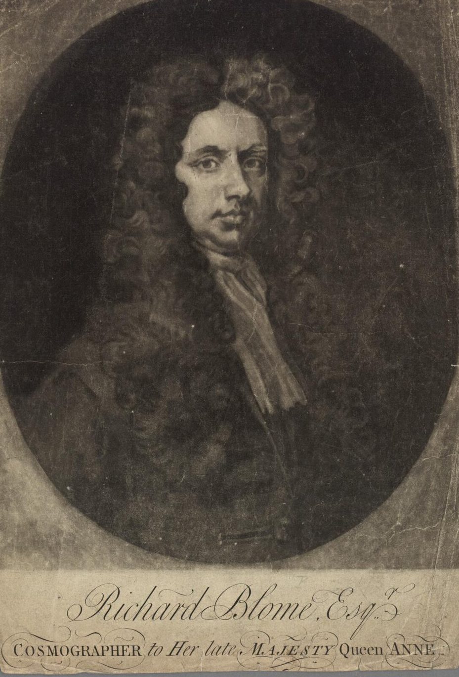
Richard Blome is one of the most interesting, and most active, publishers of illustrated books in post-Restoration London. Not only was his output varied in terms of subject and quality, but his career also gives instructive insight into the nature and activities of the London map and print trade of the period.
Unfortunately, judgements passed by three early commentators on one of Blome’s principal publications, the Britannia…, have oft been repeated as summaries of Blome’s career. In 1696, Bishop William Nicholson described the Britannia as “a most notorious piece of theft out of Camden and Speed…” 1, Anthony a Wood described it as “scribbled and transcribed from Cambden’s Britannia and Speed’s Maps” 2 while the antiquarian Richard Gough, writing in 1780, described the Britannia as “a most notorious piece of criticism…” 3. Blome was also aware of contemporary criticism of the maps in the Britannia, a view reiterated by Kingsley, who wrote: “Blome’s cartographic work… is poorly contrived and unoriginal”.
While these judgements are well deserved, they take no account of the nature of the map and print trade of the period, which nature imposed severe limitations on the freedom with which mapmakers could pursue original, capital intensive projects. It is against this background that Blome’s career needs to be re-examined and, I would argue rather greater credit given to Blome for his role, than he has hitherto received.
Blome was the son of Jacob Bloome, a member of the Stationers’ Company. He was baptised at St. Anne’s, Blackfriars, on July 10th 1635 4. With high infant mortality rates at the time, it was customary to baptise the new-born as quickly as possible, so he was presumably born in the early part of July 1635.
Confusingly, Jacob Bloome and his father, Menasses, also a Stationer, spelled the surname Bloome, while Richard invariably used Blome; however, in the Registers of the Stationers’ Company, he is given as Bloome.
Jacob Bloome’s name is found, for example, in the imprint of Sir Thomas Herbert’s 1634: A Relation Of Some Years Travaile, Begunne Anno 1626… Into Afrique And The Greater Asia, Especially The Territories Of The Persian Monarchie… By T.H. Esquier. [woodblock] London, Printed By William Stansby, And Jacob Bloome, 1634, although the colophon shows that Stansby was the actual printer. A second edition appeared in 1638, under the joint imprint of R. Bishop (who had acquired Stansby’s share from Stansby’s widow), and Bloome. The volume contained a number of engraved illustrations set in the text, including untitled maps of south-eastern Africa and Madagascar, and the Caspian Sea.
Richard Blome was freed by patrimony into the Stationers’ Company on August 6th 1660. However, he apparently first emerges as a separate businessman in 1663, which also shows his early interest in geographical publishing but not, overtly at least, mapmaking. In May of that year, the Registers of the Stationers’ Company record:
“[Richard] Bloome Entred for his cope under the hand of Doctor Franck and Master Pulleyn warden a book entituled ‘A Geographicall Descripcon of the World’, written in French by Sanson, Geographer to ye King of France & translated into English….” 5
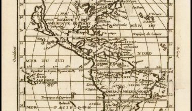
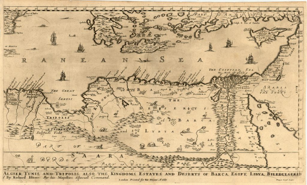
In 1667, the first of a new series of maps were engraved for Blome’s A Geographical Description Of The Four Parts Of The World… London: Printed By T.N. For R. Blome… And For Convenience Are Also Sold By Nath. Brooks… Edw. Brewster… And Tho. Basset 1670. The completed volume was in small folio, and contained 24 maps (plus one duplicated), engraved by Francis Lamb, Thomas Burnford and Wenceslas Hollar.
The maps in the atlas, as is clearly stated in the title to each, are copied from the equivalent map, published by the French geographer and mapmaker, Nicolas Sanson, and issued in his Cartes Generales de toutes les Parties du Monde of 1658.
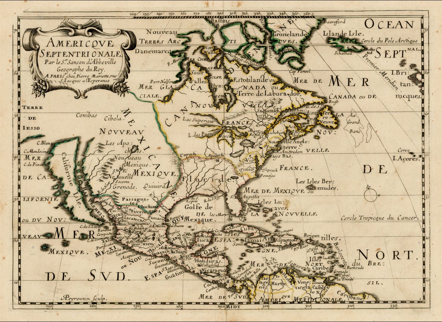
Although this was not an original publication, it is worth pointing out that this was the first new folio world atlas to be published in England since 1627, the year Speed’s Prospect Of The Most Famous Parts Of The World appeared, which also relied on continental geographical models. Furthermore, this is the first folio (and quite possibly the very first) world atlas wholly engraved, printed and published in England.
Blome’s principal handicap in the production of the atlas was the lack of a domestic mapmaking environment comparable with that existing in continental cities such as Paris and Amsterdam, which would have supplied more up-to-date models for the maps.
A secondary problem was how to finance the atlas. Evidently, at the outset of his career, he lacked the necessary money to fund the expensive process of buying the copperplates, hiring engravers, and so on. Instead, Blome sought to finance the atlas by selling subscriptions. While not the first to use this means (Wenceslas Hollar sought to underwrite his plan of London by the same means in 1658), Blome was the first to exploit the opportunities of subscriptions on a large scale, relying on subscriptions to finance all his major publications.
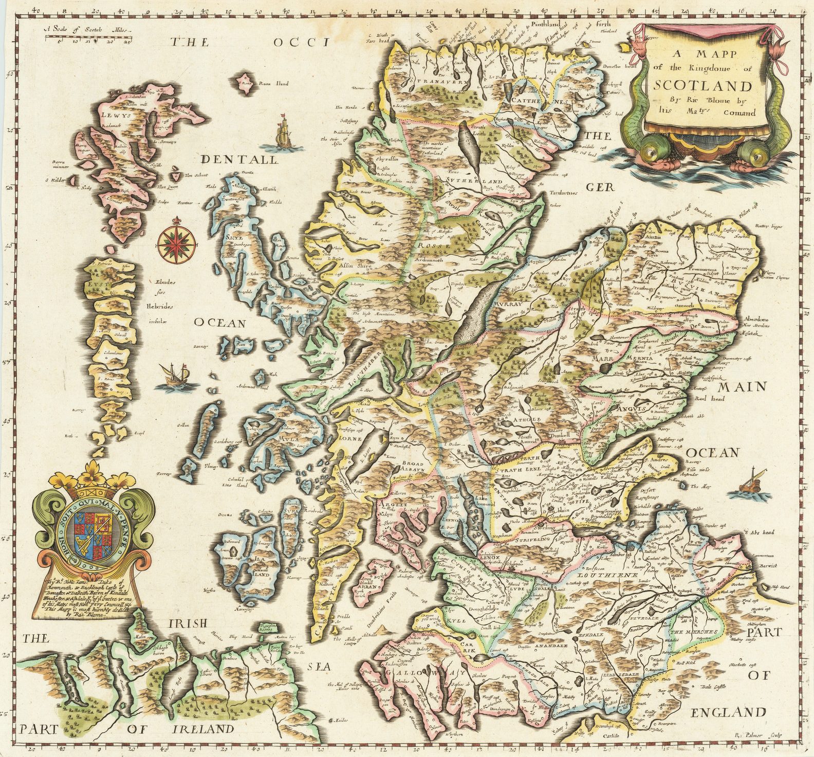
The approach was very simple. The subscriber would pay a proportion of the fee in advance, and the balance on delivery of the volume. In return, the subscriber’s arms would be engraved on the map of his choice and, in the Britannia, he would receive honourable mention within the text. According to the proposal, a subscriber to the Britannia was charged 20s., 10s. in advance, this including the engraving of the arms, 10s. on delivery, and 5s. for a mention in subsequent counties, as appropriate.
When it came to subsequent editions, existing subscribers were evidently approached for a ‘renewal fee’; if they declined, then their arms were removed, and a new subscriber’s arms substituted. The map of North America, for example, was dedicated to three different men between 1670 and 1693. At the other extreme, the map of Barbary in the First Edition contained the shields of 36 Earls, Barons, Knights, etc.
The Geographical Description seems to have been relatively successful, and there were later editions, under the title Cosmography and Geography, with text by Bernard Varenius, in 1682, 1683 and 1693.
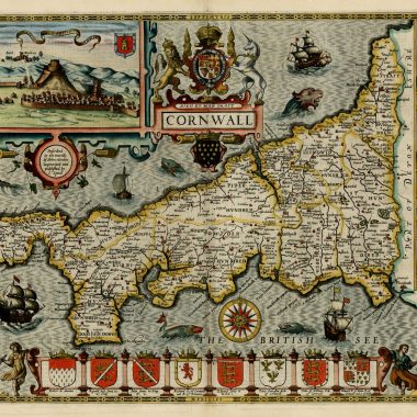
At the same time, in 1667, Blome commenced work on a small county atlas. Unfortunately, the sequence of events is confusing but it would appear that by 1671, Blome abandoned attempts to complete this atlas and, instead, disposed of the plates to another publisher. Curiously, in 1681, the map plates re-emerge in the possession of Blome, who published them as Speed’s Maps Epitomiz’d. The intermediate, and anonymous, owner seems to have done little more than erase Blome’s name from the majority of the map-titles. These erasure are clearly visible on the plates in the 1681 atlas, which also display a small number of alterations by Blome preparatory for publication, but without restoring his name on the plates. It would seem that the anonymous publisher never actually printed an edition.
While there has been some speculation about Blome’s motives, the most likely explanation is simply that by 1670 or, more likely, 1671, he had decided that the maps were not grand enough for his purposes, and that he preferred to put his energies into the Britannia, with a series of county maps prepared on a larger format. Also, the Britannia was prepared on the same format as the Geographical Description Of The Four Parts Of The World, which had been published in 1670, and Blome may have felt that having a uniform pair of volumes offered better commercial possibilities, as he had other ambitious volumes in mind.
One of the best known trade alliances of this period was that between John Ogilby and Jacob van Meurs, an Amsterdam publisher, by which Ogilby was to print English editions of travel accounts written for Meurs by Arnold Montanus, Olfert Dapper and Johannes (Jan) Nieuhoff.
It is a surprise, therefore, to read in the Registers of the Stationers’ Company for April 10th 1669:
“Master Richard Bloome Entred for his copie under the hands of Master Sam: Parker and Master Warden Smith a copie or booke intituled ‘A Generall descripcon of the kingdomes, Countryes, Isles, &c. in Affrica.’ Illustrated with variety of usefull and delightfull mapps and Figures, being a Translacon into English of a Booke written in Dutch by Doctor O. Duppar, and printed at Amsterdam in Anno 1668 Entitled, ‘Naukeurige Beschriivinge der Afrikaensche Gewesten von Egipten’ &c. To w[hi]ch is added as an Appendix by the said author, A descripcon of the Isles of Madagascar, S.t Thomas, Cape Verd, and Canarie Isles, enriched also w[i].th Mapps and figures….”6.
Yet for some reason Blome did not proceed with publication, and this book, and others by the same publisher, are found in English editions under the imprint of Blome’s principal rival, John Ogilby, published from 1669 onwards. This partnership seems to have worked favourably for Ogilby, elevating his profile within the London trade, and establishing a reputation that was to serve him well in the coming years.
Whatever reason Blome had for passing the opportunity by, he focused his attention on the Britannia, of which he seems to have high expectations, as can be seen in a broadside proposal issued in 1670 (the full text of which is given as Appendix I), which gives interesting insight into his working methods.
IN Obedience to His Majesties Royal Commands, I have undertaken to set forth a GEOGRAPHICAL DESCRIPTION of His Majesties Kingdoms and Dominions of ENGLAND, SCOTLAND, and IRELAND, with the Isles thereunto belonging, in Folio; which shall be illustrated with useful and delightful MAPPS to each County of England, besides several general ones. And for the better effecting the same, it being a Work of such general concernment, His Majesty hath been graciously pleased to grant His Encouragement for the promoting the said Work, together with His Royal Letters Recommendatory to all Justices of the peace, Sheriffs, Maiors, High-constables, Ministers, and Churchwardens; as also to all other His Loving Subjects within His Dominions, for the giving their ready aid and assistance unto me in such particulars as shall be proposed unto them, and every of them by me, as thought necessary for the perfecting of the said Work, in the rendering it more useful and profitable, and rectifying the many errors frequently committed in Books and Maps yet extant….
Part of the proposals was a request for information about the country from people with local knowledge, to correct and update existing printed authorities, most particularly Camden’s Britannia, the most extensive description of the British Isles available. It is difficult to know whether the response was large or small, but Blome’s deadline of Trinity Term 1671 came and went.
The volume was finally printed in 1673. It is clear from the ‘Preface To The Reader’ that Blome was fully aware of potential criticisms, charges which he did his best to answer, although even he does not appear to have been particularly convinced by his explanations (see Appendix 2 for a transcript of sections of the preface).
While the volume evidently received wide circulation, this is probably to be construed to be the take-up by subscribers. In other terms, Blome seems not to have judged the work as a commercial success, and by 1677, the ownership of the Britannia had passed to another publisher, John Wright, who re-issued the work in that year. He was able to use existing, remainder, text sheets, and had only to print a new title. Only one example of this edition was recorded by Skelton, which would suggested very limited sales 7.
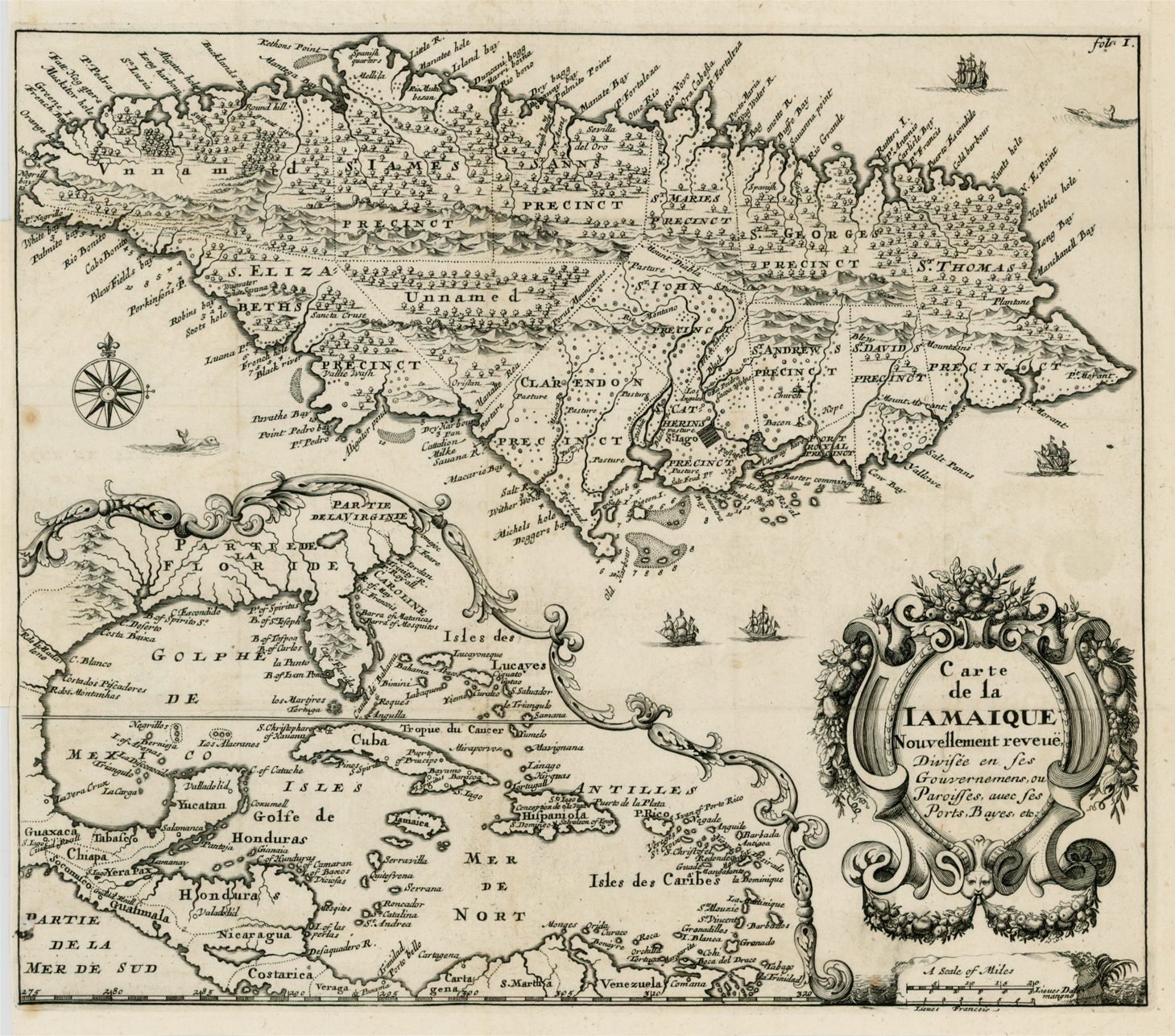
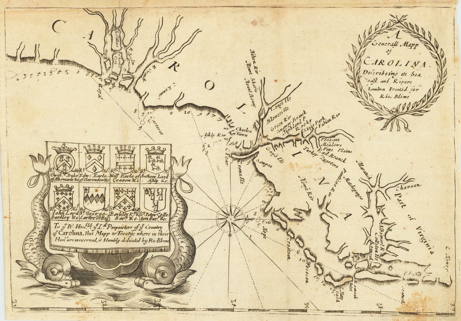
While working on the Britannia, Blome also published a small octavo volume entitled A Description Of The Island Of Jamaica, (London, 1672), containing a finely etched map of Jamaica, performed by Hollar, and a derivative of the rare Hilton map of the Carolinas. The volume was subsequently re-printed by Dorman Newman, in 1678 and 1687, the latter edition now under the title The Present State Of His Majesties Isles And Territories In America, with the text greatly expanded, and adding a set of maps acquired from Morden, previously used in the First Edition of the latter’s Geography Rectified (London, 1680).
Blome’s next venture into map-publishing was Speed’s Maps Epitomiz’d; the appearance of these maps, which Blome evidently sold to another publisher in about 1671, suggests that Blome was having to modify his aspirations. On examination, the maps are frequently crudely engraved (notwithstanding the fact that Wenceslas Hollar and Francis Lamb were employed to engrave some of them), and more frequently have evidence of very crude erasures or additions, including the removal of Blome’s name from the majority of the titles, and substitution or addition of coats of arms. Many of these changes betray the hands of several different engravers. However, the individual maps, with the coats of arms, have a certain appeal, and the atlas has surprising longevity. Blome was involved in two further editions, in 1685 and 1693; the atlas, under a new title – England Exactly Described – was subsequently re-issued first by Thomas Taylor, then Thomas Bakewell, and then finally by Elizabeth Bakewell, circa 1750 8.
In the 1680s, Blome strayed away from cartographic works towards illustrated books, perhaps hoping they might have wider appeal or greater novelty, for example The Gentleman’s Recreation. Between 1688 and 1690, Blome embarked on an ambitious publication The History Of The Old Testament… Translated From The Works Of The Learned Le Sieur De Royaumont By Mr. John Coughen, Master Of Arts And Supervised By Dr. Anthony Horneck, And Other Orthodox Divines…, printed by Samuel Roycroft, for Blome. The work, in folio, comprised two volumes, with am engraved frontispiece, five maps and plans, and 238 plates, many engraved by Johannes Kip. Subsequent editions appeared in 1699 and 1705.
Blome’s last cartographic venture is recorded only in an entry in the Registers of the Stationers Company, for November 30th 1695:
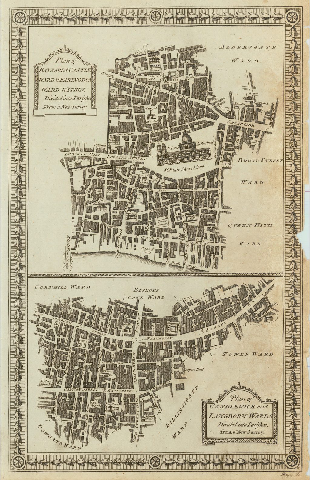
Richard Bloome Entred then for his booke or coppy under the hand of Master Warden Lowndes entituled ‘A survey or description of the citties of London and Westm[inste].r, with the Liberties and partes adjacent. Togeather with the severall American plantacons belonging to the crowne of England with Icknographicall mapps of the respective wards and parishes. Togeather with mapps of the said plantacons and other ornamentall sculptures.’ To which said booke his Ma[jes]tie has granted his royall lycense under his hand manuall. Dated the 27.th of November 1695, for the sole printing and vending the said volume, &c….9
There is evidence at least some of the maps were completed – those for the ward of London. The edition of John Stow’s A Survey Of The Cities Of London And Westminster…, edited by John Strype (London, 1720) contains a number of such plans which bear clear evidence of Blome’s name having been erased, and this is confirmed by a note in the preface that the maps were from “a careful survey made of London and Westminster, divers Years ago by Mr. Lybourn [presumably the surveyor William Leybourn] and Mr. Bloome” Blome’s plans were apparently already available to the group of publishers who proposed this new edition of Stow’s text, in an announcement in their edition of Edward Hatton’s History of London, (1708). Presumably the plates were acquired by them from Blome’s heir, after his death in 1705.
While there seems no explanation of why Blome’s project foundered, it may again relate to the difficulty of compiling an up-to-date account of London, and the projected cost of seeing such a project through the press. The editions of Hatton and Stow mentioned above were published by large consortiums of important booksellers, but even so the edition of Stow took twelve years to complete, from proposal to publication.
Blome died between May 7th 1705, when his will was signed, and October 22nd of the same year. In the will he left his estate to his companion, Mrs. Jane Hilton.10 Laurence Worms has traced an earlier reference to the marriage of a Richard Blome in Carmarthen on October 19th 1681, but whether this is the same man (and the name is not common), and what became of the spouse is not known.
It would be hard to claim a successful career for Blome, but he occupies a very important position in the history of the English map-trade of the seventeenth century. He was the first publisher in England for 40 years to prepare a new folio world atlas, the first in over sixty years to publish a new set of (albeit small) folio county maps, the first to seriously plan an illustrated description of London, and the first to plan a series of volumes related to the various Continents of the World. Moreover, all this from one who came from a publishing rather than cartographic background.
Blome can be seen as one of the most active publishers of the 1670’s, in conjunction with John Seller Sr., and John Ogilby. While Seller failed more spectacularly, Ogilby very much followed in Blome’s footsteps (most particularly with the relationship with Jacob van Meurs) but his more favourable financial situation (at times), his ability as a surveyor, and his royal patronage, afforded him advantages that Blome could not match.
It is a shame that Blome was not more innovative, but it is hard to see how he could have been. It is clear that he had neither the background nor resources to be more ambitious, but in pioneering use of subscription publishing, he opened fresh avenues for subsequent publishers, such as Moses Pitt, and for would-be publishers of large scale surveys of the individual counties.
Appendix 1: Broadsheet Proposals for the Britannia
IN Obedience to His Majesties Royal Commands, I have undertaken to set forth a GEOGRAPHICAL DESCRIPTION of His Majesties Kingdoms and Dominions of ENGLAND, SCOTLAND, and IRELAND, with the Isles thereunto belonging, in Folio; which shall be illustrated with useful and delightful MAPPS to each County of England, besides several general ones. And for the better effecting the same, it being a Work of such general concernment, His Majesty hath been graciously pleased to grant His Encouragement for the promoting the said Work, together with His Royal Letters Recommendatory to all Justices of the peace, Sheriffs, Maiors, High-constables, Ministers, and Churchwardens; as also to all other His Loving Subjects within His Dominions, for the giving their ready aid and assistance unto me in such particulars as shall be proposed unto them, and every of them by me, as thought necessary for the perfecting of the said Work, in the rendering it more useful and profitable, and rectifying the many errors frequently committed in Books and Maps yet extant. And His Majesty has been graciously pleas’d to signifie his Royal Pleasure, that they will do an acceptable Service to Him and His Nation.
In pursuance whereof I do request the Favour of all persons that would be esteemed Friends to their Country in promoting so good a Work; to give their ready aid and assistance to me, as so such things that are best known unto them in the parts or Towns wherein they reside, or are well acquainted with, and chiefly to these particulars following, which are intended Geographically to be treated of in the said Volumn, which they are desired to send unto me with all possible speed, the said Volumn being intended to be printed by Trinity Term 1671.
The Names of all Market=towns known unto you; in what County or Counties and Division or Hundred in the said County or Counties, they are scituated in, whether on or near the Sea, or an Arm thereof, on or near a River, and its Name (if any) and whither the said River be fordable, and hath the conveniency for Vessels or Barges, and are places of trade by reason thereof.
Whether seated on a Hill or in a Plain, Valley, or Bottom; whether in a healthful Air and pleasant Situation; whether the Ground be Champion, Wood-land, or a mixture of both; of what soil, and whether most fit for grazing or tillage.
Whether seated on any of the high Roads of England, and which.
The extent or bigness, and form of the said Towns, how many Churches they have, and what Villages, Hamblets, or Endships doth belong to the said Towns or Parishes.
The days of the Markets, what Commodities they chiefly affoard, and what Manufactures are made and sold therein, and whether they are considerable, indifferent, or small Markets.
If a City, Maior, Burrough, Baliffwick, or Town Corporate; an account thereof, as to its Immunities, privileges, and how govern�d.
The Names of such Towns or places that have the conveniency of Fairs, whether Cities, Market-towns, or others of less note, and an account thereof as to what days they are kept on, how long they last, in what commodities they chiefly consist, and whether considerable, indifferent, or small.
What places of Antiquity worthy of note, as Nunneries, Priories, and other Religious Houses; as also what Castles, Forts, or other decayed places are or were in or near the said Towns known to you, and an account thereof.
If a Sea-port or Maritime Town, an account thereof as its Haven, and whether a place of Trade.
What Nobility and Gentry (of repute)inhabit or have Estates in or near the said Towns or Parishes known unto you, and an account thereof as to their Names, Titles, and Seats, as also their Coats of Arms if known unto you.
And that none may take exceptions if omitted in the said Work as having no notice thereof, I do humbly make this Proposal.
A PROPOSAL made by me Richard Blome, lodging at Mr. Kids at the corner of Lincolns Inne Field near New market.
Those that will be pleased for the advancement of the said Work to subscribe and pay unto the said Richard Blome the summe of 20s. shall have one of the said Books presented them, in which they shall have their Coat of Arms (so as allowd of by the Kings at Arms) affixed to the Mapp of the county to which they are related unto, and by them made choice of as Friends to the said Work, to remain to Future Ages: 10s. to be paid down towards the Charges thereof, and Allowance of the said Coat of Arms, and the remaining 10s. to be paid upon the delivery of one of the said Books as aforesaid. But if mentioned in more than one County, then 5s. more for every other County they are so mentioned in.
Those that for the advancement of the said Work will subscribe or procure Subscriptions for 6 of the said Books as aforesaid, shall for their encouragement upon the performance of their said Subscriptions have one of the said Books presented them gratis.
Those that will be pleased to be mentioned in the said Work as aforesaid, and do subscribe accordingly, are desired to bring or send such their Subscriptions, with Directions for the affixing their Name, Title, Seat, and Coat of Arms as aforesaid, to the Mapp or Mapps of the County or Counties to which they are related unto with all convenient speed, unto my Lodgings as aforesaid, the said Volumn being intended to be finished by Trinity Term 1671.
In consideration of the premises aforesaid, I do promise and engage to take and receive of the said Richard Blome, or his Assigns, one of the said Books according to the said Proposition, and to be mentioned acordingly in the County or Counties of [gap] Witness my Hand this [gap] day of [gap] Anno Dom. 167[0]
Appendix 2: Blome’s Britannia: THE PREFACE TO THE READER.
IN this Nice Age, I cannot but expect to meet with censorious Criticks, who out of some self ends, or to be judged persons expert in the knowledge of their Country will villifie this Work, and question my ability to perform so great an Vndertaking. Others may say it is unnecessary, for that the Nation is so well furnished with approved Authors of this Subject, as well those in general, as Mr. Cambden and Speed; as those of particular Counties. Some may also judge the Work Imperfect, for that (’tis probably) some Market towns, Castles, Rivers, Hills, Parks, Medicinal Springs, or places of Note (either for Antiquity or wonder) are omitted, or at least not fully treated of: Likewise some expert in Geography may find fault with the Mapps; and some others may probably take exceptions as being omitted in the said Work, when others of less eminency are taken notice of: or for that there may be some mistakes in their Names, Titles, or Seats.
Modestly to answer these, or the like supposed Objections, give me leave to say; That I do not own my self the Author, but the Undertaker of this Work, it receiving Birth from divers Manuscripts, from all Books yet extant that have writ of the same subject, as well in general, as in particular: and from some hundreds of experienced persons in the several parts of this Kingdom of England, who have freely contributed their assisting hands in the promoting the same, and rectifying or enlarging the descriptions of such places, &c. as are known unto them, as occasion required according to the method herein treated of; and it is my opinion that it is an Vndertaking to[o] great and difficult to be performed by any one person now living, without the assistance of others.
That as to the utility thereof, ’tis true, there are several worthy and approved Authors, which in their wayes deserve great applause, and have been well received; which hath emboldned me to go forwards with this Vndertaking, and the rather for these Reasons; That Cambden is a very dear Book, scarce, much out of print, and never like to be reprinted; nor would it be acceptable in this our age, the face of the Kingdom being so much changed to what it then was… for as to his Geographical, or rather Topographical Descriptions of the Towns in each County, he is very short and imperfect; neither are his Mapps much to be commended. That for Speed, his descriptions are more short, but his Mapps in general are the best yet extant, which hath occasioned them to be so well approved of, that with usage they are (or soon will) become useless; And thus much I may be bold to say, That (as to England) you will find divers things, and places of note and concernment here treated of, which are omitted in others: But for Scotland and Ireland I do not much pretend to; yet as Kingdoms belonging unto his Majesty, I have given them short descriptions thereof, as I have done of those American Plantations to which the English are so eminently related.
…
That as to the Mapps [in the ‘Britannia’], I cannot justifie them without fault, yet I may say, they are not much inferiour to the best yet extant for truth, though for sightliness (as being in a smaller scale) they may be (by some) deemed not so graceful; and I hope the Reader will be so partial as not to condemn them for their faults until they have recourse to those of Speeds from which they were taken, for I do not pretend to a new survey. And I am of the opinion, That there are none (nor ever will be any) made without faults, either in the position, omission, or mis-calling of place, the courses of Rivers, the division, form or extent of the Country: yet there may be some that by new Surveys may pretend to do much in the rectifying all such errors, and to make them faultless, which I should be heartily glad to see, as being a Work of such general good.
Appendix 3: Blome’s addresses, based on Tyacke’s list 11, but with revisions:
1669-1670 Dwelling In The Savoy Near The Kings Wardrobe
1670-1673 At Mr. Kid’s In The Corner Of Lincoln’s Inn Fields Near New Market
1673 At The Corner Of Lincoln’s Inn Fields In Sheffield Street, Near Clare
Market
1684 At His Lodgings At Mr. Conimes Next The Hanging Sword In Salisbury Court
1686 Dwelling In The Country… [Tuesday & Saturday at] At Mr. Rowes At Ye Black Fryers On Ye Backside Of The Green Dragon Tavern In Fleet Street
1688 At The Upper End Of Duchy-Lane Near Somerset House In The Strand
1688 [At The Upper End Of ?] Wardour-Street Near The Spotted-Dog In St. Giles-Road, Near The Soho
1690-1691 In King Street By Golden Square, Near The Chapel
1692 At Mr. Richards His Bookbinder In Stanhope Street Near Clare Market
1693-1696 Dwelling Near Clare Market In New Weldstreet At The Green Pallisado-Pales
1705 Durham Yard
References:
(1) quoted by R.A. Skelton, County Atlases of the British Isles (Reprint edition, Folkestone, William Dawson & Son, 1970), p.142.
(2) quoted by David Kingsley, Printed Maps of Sussex 1575-1900, p.39
(3) quoted by R.A. Skelton, op. cit, p.142.
(4) This information was recently discovered by Laurence Worms, as part of his biographical extensive research into English engravers and mapmakers.
(5) Eyre, Stationers’ Company Registers, 1640-1708, II, p.323.
(6) Eyre, Stationers’ Company Registers, 1640-1708, II, p.399.
(7) Skelton, op. cit., no.100
(8) The history of the plates is traced in Skelton op. cit. no. 104, 105 and 114, subsequently continued by Donald Hodson, County Atlases of the British Isles Published after 1703 Volume 1, nos.139-141
(9) Eyre, Stationers’ Company Registers, 1640-1708, III, p.466;
(10) Sarah Tayacke, London Map-Sellers 1660-1720, (Tring, Hertfordshire: Map Collector Publication Ltd., 1978), p.111.
(11) Tyacke, op. cit., p.110-111;