| 1. | [1648] DUDLEY, Sir Robert state 1 Carta particolare della Virgi= / nia Vecchia è Nuoua. / La longitu:ne Comi:ca da l’Isola di Pico d’Asores. / D’America Carta. III. [5c] AF: Lucini Fece. [5e] From: Dudley Arcano Del Mare 1646-1648 | 451 x 370 W: 479 x 370 PM: 479 x 379 Not in the Kendall Collection Catalogue; Cumming, Southeast, 44; Nordenskiold Collection Catalogue, I, 70, [101]; Skelton, Decorative Printed Maps, pl.62. |
| 2. | [1648] DUDLEY, Sir Robert state 2 [1661] Carta particolare della Virgi= / nia Vecchia è Nuoua. / La longitu:ne Comi:ca da l’Isola di Pico d’Asores. / D’America Carta. III. L.o 6.o [5c] AF: Lucini Fece. [5e]From: Dudley Arcano Del Mare 1661 | 453 x 368 W: 481 x 369 PM: 481 x 381 Not in the Kendall Collection Catalogue; Cumming, Southeast, 44 (pl.27) |
| 3. | [1648] DUDLEY, Sir Robert state 1 Carta particolare della costa di / Florida è di Virginia. / La longitudine, Cominca da lisola di Pico d’Asores. / D’America Carta IIII. [1b] AF: Lucini Fece. [5e] From: Dudley Arcano Del Mare 1646-1648 | 453 x 361 W: 473 x 376 PM: 473 x 385 Not In the Kendall Collection; Cumming, Southeast, 45; Lowery, 109; Nordenskiold Collection CataIogue, I, 70, [102] |
| 4. | [1648] DUDLEY, Sir Robert state 2 [1661] Carta particolare della costa di / Florida è di Virginia. / La longitudine, Cominca da lisola di Pico d’Asores. / D’America Carta IIII. L.o 6.o [1b] AF: Lucini Fece. [5e] From: Dudley Arcano Del Mare 1661 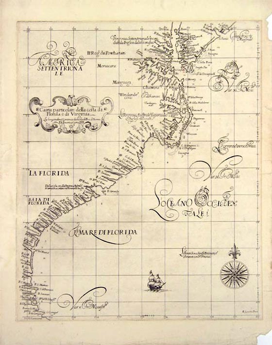 | 453 x 361 W: 474 x 375 PM: 474 x 385 Cumming, Southeast, 45 (pl.28); Johnson, America Explored, p.125 (ill) |
| 5. | [1675] ROGGEVEEN, Arent Caerte vande Cust van Florida tot de Verginis Streckende van Cabo de Canaveral tot Baya de la Madalena.’ ’25’ From: Roggeveen Het Brandende Veen … West-Indien, 1675 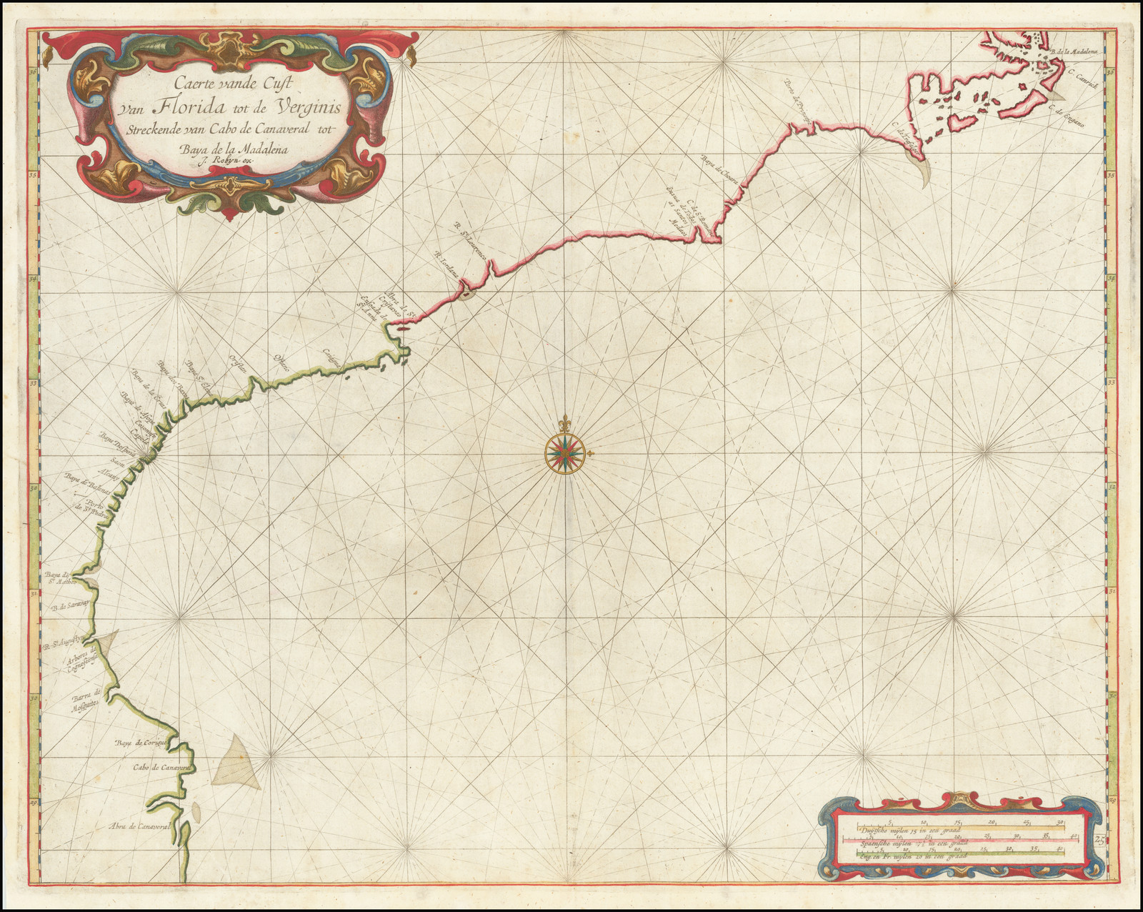 | 411 x 527 PM: 422 x 541 Cumming, Southeast, 74; Koeman, IV, Rog.1 (26); Lowery, 162 |
| 6. | [1684] VAN KEULEN, Johannes state 1 Pas Kaart / Van de Kust van / CAROLINA / Tusschen / C. de Canaveral en C. Henry / door CIVooght Geometra / T AMSTERDAM By / JOHANNIS VAN KEULEN / Boek en Zee Kaart verkoper aande Niewen brugh / Inde Gekroonde Lootsman / Met Privilegie voor 15 Iaaren. [4c] Inset: De Kust van CAROLINA Tusschen Riviers Mondt en C. de S. Romano in’t Groot. From: Van Keulen’s ‘Zee-Fakkel’ [1684] | 517 x 583 Inset: (ib) 143 x 212 PM: 522 x 592 Cumming, Southeast, 91 |
| 7. | [1684] VAN KEULEN, Johannes state 2 [1687] Pas Kaart / Van de Kust van / CAROLINA / Tusschen / C. de Canaveral en C. Henry / door CIVooght Geometra / T AMSTERDAM By / JOHANNIS VAN KEULEN / Boek en Zee Kaart verkoper aande Niewen brugh / Inde Gekroonde Lootsman / Met Privilegie voor 15 Iaaren. [4c] 18 [1e] Inset: De Kust van CAROLINA Tusschen Riviers Mondt en C. de S. Romano in’t Groot. From: Van Keulen’s ‘Zee-Fakkel’ 1687 | 517 x 583 Inset: (ib) 143 x 212 PM: 522 x 592 State 2: with the plate-number ’18’ added in the lower left corner. Cumming, Southeast, 91 (pl.40) |
| 8. | [1684] VAN KEULEN, Johannes state 3 [1702] Pas Kaart / Van de Kust van / CAROLINA / Tusschen / C. de Canaveral en C. Henry / door CIVooght Geometra / T AMSTERDAM By / JOHANNIS VAN KEULEN / Boek en Zee Kaart verkoper aande Niewen brugh / Inde Gekroonde Lootsman / Met Privilegie voor 15 Iaaren. [4c] 18 [1e] 18 [5e] Inset: De Kust van CAROLINA Tusschen Riviers Mondt en C. de S. Romano in’t Groot. From: Van Keulen’s ‘Zee-Fakkel’ 1702 | 517 x 583 Inset: (ib) 143 x 212 PM: 522 x 592 State 3: with the second plate-number ’18’ added in the lower right corner. Cumming, Southeast, 91 |
| 9. | 1687 ROBIJN, Jacobus state 1 Caerte vande Cust van Carolina, Tusschen B. de S. Matheo en C. Henry, op nieuw verbetert door Jacobus Robyn, met privilegio voor 15 Iaaren A.o 1687. Inset: ‘La Partie Du Carolina Grand Point’ From: Roggeveen ‘The Fifth Part Of The Enlarged Lightning Sea-Column’ 1688 | Koeman, IV, Rog.6, (28) |
| 10. | 1687 ROBIJN, Jacobus state 2 1697 ‘Caerte vande Cust van Carolina, Tusschen B. de S. Matheo en C. Henry, op nieuw verbetert door Jacobus Robyn, met privilegio voor 15 Iaaren A.o 1697.’ ’25’ Inset: ‘La Partie Du Carolina Grand Point’From: Roggeveen ‘Het Eerste Deel Van Het Brandende Veen …’ 1698 | State 2: with the date in the title altered to 1697, and the plate number inserted. Koeman, IV, Rog.4, (27) |
| 11. | 1687 ROBIJN, Jacobus state 3 1706 ‘Caerte vande Cust van Carolina, Tusschen B. de S. Matheo en C. Henry, op nieuw verbetert door Ioannes Loots met privilegio voor 15 Iaaren A.o 1706.‘ Inset: ‘La Partie Du Carolina Grand Point’ From: Loots ‘The Fifth Part Of The New Great Sea Mirrour …’ 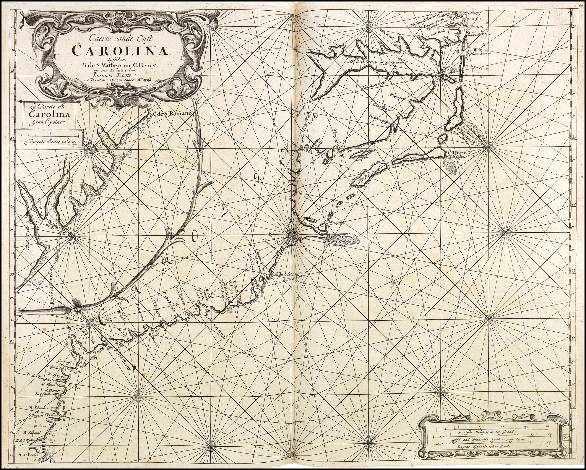 | State 3: Loots’ title has been inserted in the title, and the date advanced to 1706. Koeman, IV, Rog.8; Cumming, Southeast, 140 |
| 12. | [1689] THORNTON, John & FISHER, William state 1 A New Mapp of / CAROLINA / By John Thornton at y.e Platt in y.e Mino.ries / And by Will: Fisher at y.e Postorn Gate / on Tower hill / London. [2d] Inset: ‘A Large Draught of Ashly / and Coopers Rivers.’ [4b; 4a/4b – 5a/5b]From: The English Pilot. The Fourth Book 1689 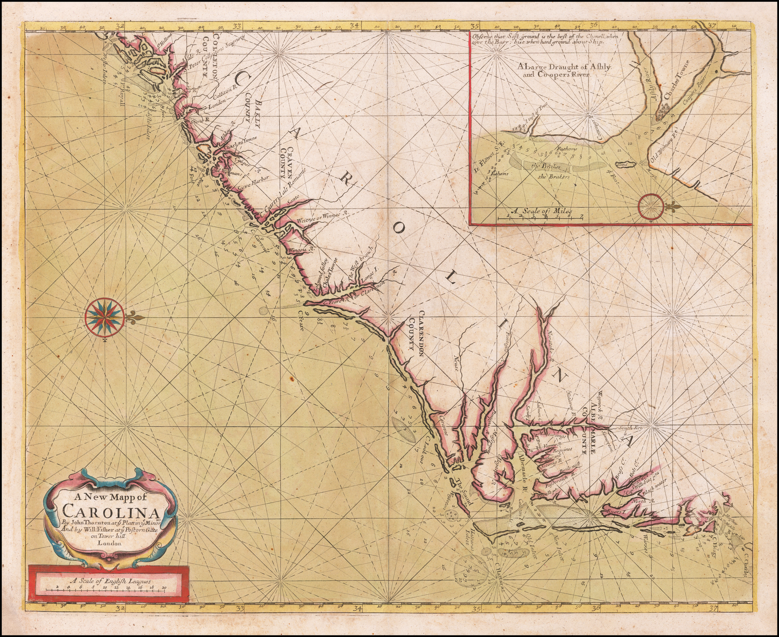 | 425 x 519 Inset: 145 x 200 PM: 431 x 524 Cumming, Southeast, 123 |
| 13. | [1689] THORNTON, John & FISHER, William state 2 [1728] A New Mapp of / CAROLINA / [erasure]. [2d] Inset: ‘A Large Draught of Ashly / and Coopers Rivers.’ [4b; 4a/4b – 5a/5b] From: The English Pilot. The Fourth Book 1728 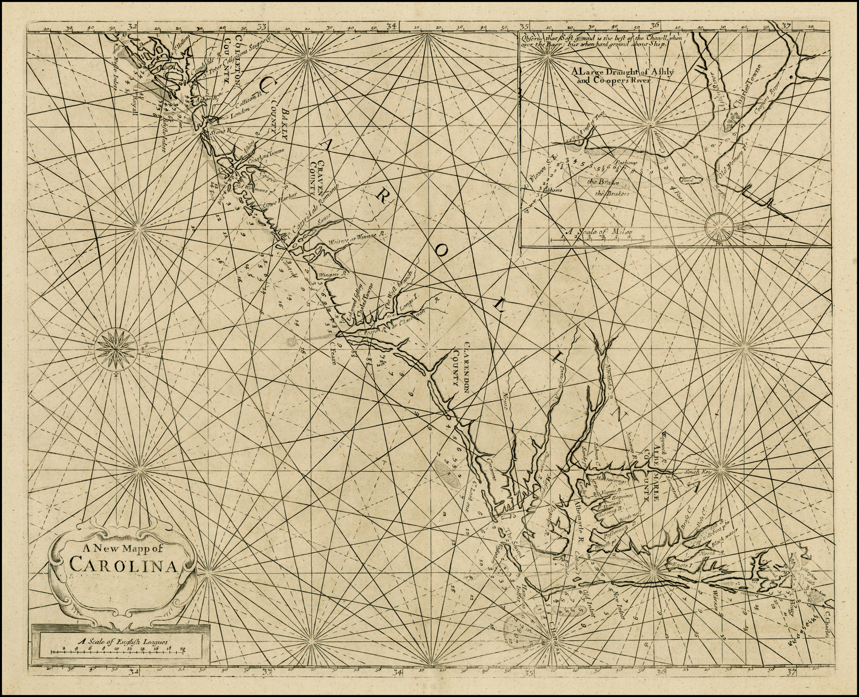 | 421 x 413 IN: 137 x 198 PM: 425 x 518 State 2: with the imprint erased from the title. Cumming, Southeast, 123 |
| 14. | [1703] SELLER, Jeremiah & PRICE, Charles Sr. state 1 A Chart of / CAROLINA. / [rule] / By Jer: Seller & Cha: Price / at the Hermitage in Wapping / LONDON. [2b] Inset: ASHLEY & / COOPER / RIVER. [5d; 4d/e – 5d/e] From: Seller & Price The English Pilot Book Four 1703 | 535 x 436 Inset: 131 x 159 PM: 538 x 439 Not in Cumming, Southeast |
| 15. | [1703] SELLER, Jeremiah & PRICE, Charles Sr. state 2 [1730 ca] A Chart of / CAROLINA. / [rule] / [erasure]. [2b] Inset: ASHLEY & / COOPER / RIVER. Mount & Page Separate publication [?] | 535 x 436 PM: 538 x 439 Inset: 131 x 159 Cumming, 127 |
| 16. | [1706] THORNTON, John state 1 A Large Draft of / SOUTH CAROLINA / from Cape Roman to Port Royall. / [rule] / By John Thornton Hydrographer at the Signe of England Scotland / and Ireland in the Minories / LONDON. [2a] From: The English Pilot. The Fourth Book 7061 | 449 x 553 Widest: 449 x 573 PM: 459 x 573 Cumming, Southeast, 144 |
| 17. | [1706] THORNTON, John state 2 [1716 ca.] A Large Draft of / SOUTH CAROLINA / from Cape Roman to Port Royall. / [rule] / By Sam.l Thornton Hydrographer at the Signe of England Scotland / and Ireland in the Minories / LONDON. [2a] From: Mount & Page [Untitled Sea-Atlas] [ca. 1716] | 449 x 553 W: 449 x 573 PM: 449 x 573 Cumming, Southeast, 144 |
| 18. | [1706] THORNTON, John state 3 [1764] A Large Draft of / SOUTH CAROLINA / from Cape Roman to Port Royall. / [rule] / Sold by W. and I. Mount & T. Page, / on Tower Hill LONDON. [2a] From: The English Pilot. The Fourth Book 1764 | 449 x 553 Widest: 449 x 573 PM: 459 x 573 Cumming, Southeast, 144 |
| 19. | [1738]: WIMBLE, James [Untitled Chart Of North Carolina] J. Mynde [5e, in border] Sold by W. Mount / & T. Page on Tower / hill and J. Hawkins / in Fenchurch street London / and the Author at / Boston in New England. [5e] Mount & Page Separate publication | L: 569 x 478 PM: 588 x 498 R: 573 x 481 PM: 595 x 500 joined: 573 x 959 PM: 595 x 978 Cumming, Southeast, 241 |
| 20. | [1745 ca.] HUGHES, Andrew A DRAUGHT / of / SOUTH CAROLINA / and / GEORGIA / from / SEWEE to ST. ESTACA / by / ANDREW HUGHES. [5a] Sold by W. Mount and T. Page on Tower hill London. [4b] Mount & Page Separate publication | 470 x 830 |
| 21. | [1749] GRIERSON, George A New Mapp of / CAROLINA / By John Thornton at y.e Platt in / y.e Minories And by Will: Fisher / at y.e Postorn Gale on Tower hill / London. [2d] Inset: ‘A Large Draught of Ashly / and Coopers River.’ [4b; 4a/4b – 5a/5b] From: Grierson ‘The English Pilot. The Fourth Book’ Dublin, 1749 | 418 x 505 Inset: 145 x 195 PM: 430 x – Cumming, Southeast, 361 |
| 22. | [1761?] DUNBIBIN, Daniel state 1 [Chart Of The Coast Of America From Cape Hateras (Sic) To Cape Roman (Sic) From The Actual Surveys Of Dl. Dunbibin Esqr] Dunbibin Separate publication | The chart was advertised in the ‘Boston Gazette’ for September 14th 1761: “The Navigation on the Coast of North and South Carolina being very dangerous on account of the many Bars, Shoals, Sandbanks, Rocks, etc. The late Daniel Dunbibin, Esq: of North Carolina, has, at very great Expense and Labour, draughted the Sea Coast of both the Provinces in a large whole Sheet Chart of 33 Inches by 23; together with all the Rivers, Bays, Inlets, Islands, Brooks, Bars, Shoals, Rocks, Soundings, Currents, &c. with necessary Directions to render the Navigation both easy and safe, and are much esteemed by the most expert Pilots: – A few of the Draughts may be had of the Subscriber if apply’d for directly. Edmund Quincy, jun. Broker.” (quoted by Wheat & Brun). Wheat & Brun, 575: with no known example |
| 23. | [1761?] DUNBIBIN, Daniel state 2 [1791] Chart of the Coast of America From Cape Hateras (sic) To Cape Roman (sic) From The Actual Surveys Of Dl. Dunbibin Esqr.From: John Norman ‘The American Pilot …’ Boston, 1791 | Printed from two plates, 520 x 810 State 2?. Wheat & Brun, 578; cf. Cumming, Southeast, p.52 |
| 24. | [1761?] DUNBIBIN, Daniel state 3 [1794] Chart of the Coast of America From Cape Hateras (sic) To Cape Roman (sic) From The Actual Surveys Of Dl. Dunbibin Esqr. From: John Norman ‘The American Pilot …’ Boston, 1794 | Printed from two plates, 520 x 810 State 3: ‘New Inlet’ has been added just north of Cape Fear. Wheat & Brun, 580. |
| 25. | [1761?] DUNBIBIN, Daniel state 4 [1798] Chart of the Coast of America From Cape Hateras (sic) To Cape Roman (sic) From The Actual Surveys Of Dl. Dunbibin Esqr. From: John Norman ‘The American Pilot …’ Boston, 1798 | Printed from two plates, 520 x 810 State 4: many of the lines of the plate have been strengthened by recutting, and the 3 Lookout shoals below Cape Lookout are now definitely outlined, each with a single line of uniform dots. Wheat & Brun, 589. |
| 26. | [1761?] DUNBIBIN, Daniel state 5 [1803] Chart of the Coast of America From Cape Hateras (sic) To Cape Roman (sic) From The Actual Surveys Of Dl. Dunbibin Esqr. From: John Norman ‘The American Pilot …’ Boston, 1803 | Printed from two plates, 520 x 810 State 5: with further recutting; the lettering in ‘Dl. Dunbibin’ in the title is now fully shaded as is also ‘Coast of America.’ cf. Wheat & Brun, 589. |
| 27. | 1777: LE ROUGE, George Louis NOUVELLE CARTE DES CÔTES / DES CAROLINES / SEPTENTRIONALES ET MERIDIONALES / du Cap Fear a Sud Edisto / Levées et Sondées par N. Pocock en 1770. / Traduites de l’Anglois. / A PARIS / Chez LE ROUGE rue / des Grands Augustins. / 1777. [1c] Inset: [Coastal Profiles] 1a/b – 3a/b] From: Le Rouge ‘Pilote Ameriquain Septentrionale’ Paris, [1778] 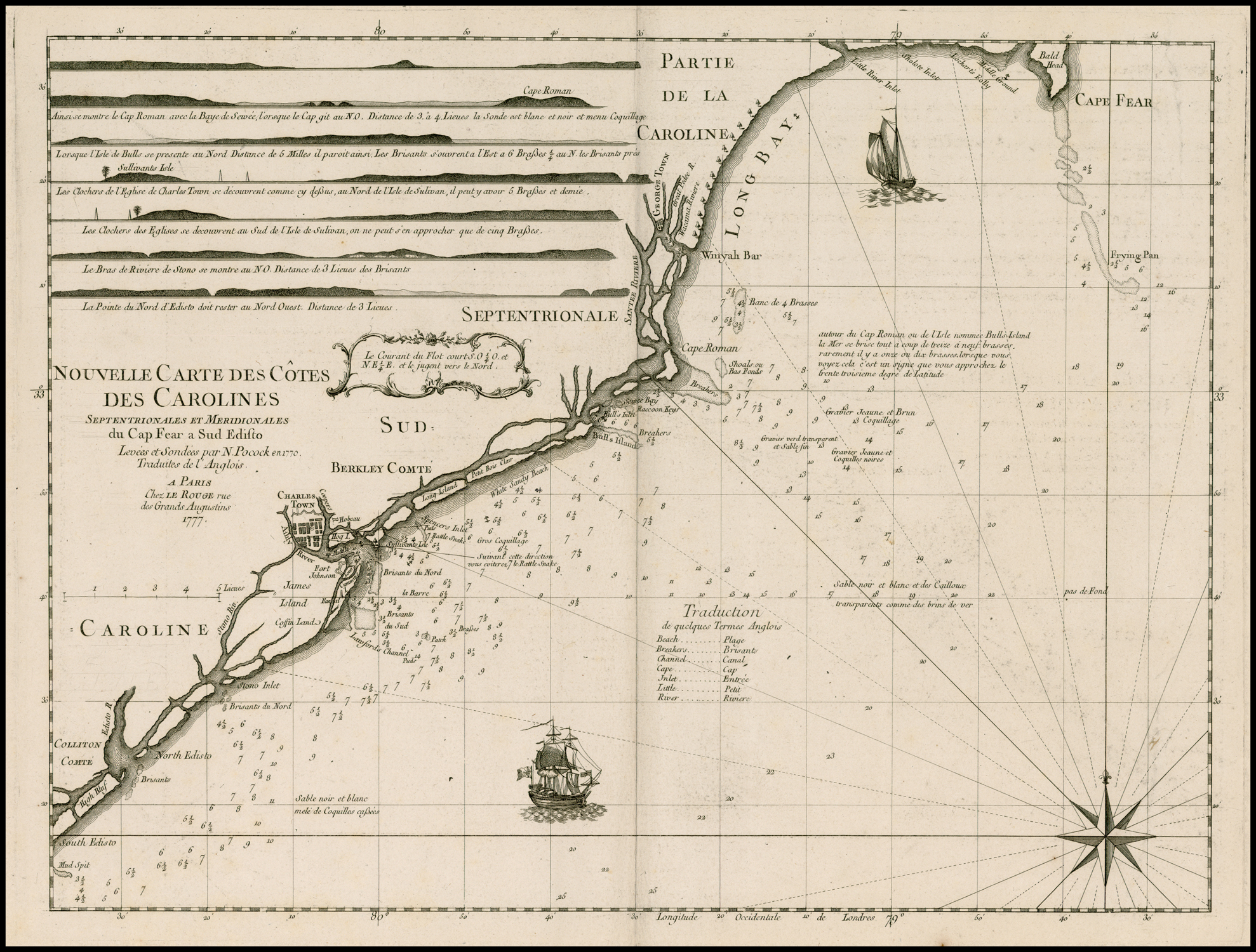 | 410 x 535 |
| 28. | 1778 PETIT state 1 CARTE RÉDUITE / DES CÔTES ORIENTALES / DE L’AMÉRIQUE SEPTENTRIONALE / CONTENANT / Partie du Nouveau Jersey, la Pen-sylvanie, le Mary-Land, la Virginie, / la Caroline Septentrionale, la Caroline Meridionale et la Georgie, / Assujettie aux Observations les plus recentes et aux Cartes de detail les plus estimées. / Dressée au Dépôt Général des Cartes, Plans et Journaux de la Marine. / POUR LE SERVICE DES VAISSEAUX FRANÇAIS / Par Ordre de M. DE SARTINE, Conseiller d’Etat, / Ministre et Secretaire d’Etat, ayant le Département de la Marine. / 1778. [1a] Gravé par Petit, Graveur du Roi et de la Marine. [1e, ob] From: Depot De La Marine ‘Neptune Americo-Septentrional’ Paris, [1780] | 585 x 869 PM: 608 x 895 |
| 29. | 1778 PETIT state 2 [1790 ca] CARTE RÉDUITE / DES CÔTES ORIENTALES / DE L’AMÉRIQUE SEPTENTRIONALE / CONTENANT / Partie du Nouveau Jersey, la Pen-sylvanie, le Mary-Land, la Virginie, / la Caroline Septentrionale, la Caroline Meridionale et la Georgie, / Assujettie aux Observations les plus recentes et aux Cartes de detail les plus estimées. / Dressée au Dépôt Général des Cartes, Plans et Journaux de la Marine. / POUR LE SERVICE DES VAISSEAUX FRANÇAIS / Par Ordre de M. DE SARTINE, Conseiller d’Etat, / Ministre et Secretaire d’Etat, ayant le Département de la Marine. / 1778. [1a] Gravé par Petit, Graveur du Roi et de la Marine. [1e, ob] 2 [5a, ob] [stamp] DEPOT GENERAL DE LA MARINE. [2b] PRIX Trois Livres. [5e, ob] From: Depot De La Marine ‘Neptune Americo-Septentrional’ Paris, [ca.1790] | 585 x 869 PM: 608 x 895 State 2: Petit’s title has been removed, the plate number, price and credit to the Depot General de la Marine have been inserted. |
| 30. | 1778 PETIT state 3 [1800 ca] CARTE RÉDUITE / DES CÔTES ORIENTALES / DE L’AMÉRIQUE SEPTENTRIONALE / CONTENANT / Partie du Nouveau Jersey, la Pen-sylvanie, le Mary-Land, la Virginie, / la Caroline Septentrionale, la Caroline Meridionale et la Georgie, / Assujettie aux Observations les plus recentes et aux Cartes de detail les plus estimées. / Dressée au Dépôt Général des Cartes, Plans et Journaux de la Marine. / POUR LE SERVICE DES VAISSEAUX FRANÇAIS / Par Ordre de M. DE SARTINE, Conseiller d’Etat, / Ministre et Secretaire d’Etat, ayant le Département de la Marine. / 1778. [1a] Gravé par Petit, Graveur du Roi et de la Marine. [1e, ob] N.o 2 (Hyd. N.o 62) [5a, ob] [stamp] DEPOT GENERAL DE LA MARINE. [2b] PRIX Trois Livres. [5e, ob] From: Depot De La Marine ‘Neptune Americo-Septentrional’ Paris, [ca.1800] | 585 x 869 PM: 608 x 895 State 3: The plate number has been amended, and the Depot General de la Marine seal, with the intials ‘R F’ (Republique Francaise), inserted. |
| 31 | 1784: KEULEN, Gerard Hulst van THE COAST / OF / A PART OF NORTH CAROLINA, SOUTH / CAROLINA, GEORGIA AND PART OF / EAST FLORIDA, WITH THE / BAYS, SOUDINGS, BANKS, ROKS, SHOALS, CURRENTS, / and other NAUTICAL REMARKS, CORRECTET and / IMPROVED from the ORIGINAL MATERIALS / and the latest ACTUAL SURVEYS. / To be sold at AMSTERDAM bÿ G: H: van KEULEN. / ANNO 1784. [5e] From: Keulen ‘Eene Verzameling Van Nieuwe Zee-Kaarten Van Noord-America In Het Groot Beginnende Van Kaap Charles, Of De Golf Van St. Laurens, Tot Aan De Golf Van Mexico …’ Amsterdam, [ca. 1785] | Map: 620 x 1105 Inset: 441 x 415 |
| 32. | 1785: STEEL, David A Chart / OF / NORTH CAROLINA, SOUTH CAROLINA, / Georgia / – AND – / EAST FLORIDA. / [double rule]. [1b] Published as the Act directs by David Steel, Union Row, Tower Hill, July 25 1785. [2b] Inset: A PLAN / of the / HARBOUR of S.T AUGUSTIN. 2d; 2d/e] PORT ROYAL HARBOUR [3d; 3d/e] VIEW OF CHARLESTON. [4a] The / HARBOUR / of / CHARLES TOWN. [4b; 4b-5b] From: Steel Separate publication, London, 1785 | 745 x 1295. |
| 33. | [1787]: BOUCHER, Odet-Julien le CARTE REDUITE DU SUD DES ETATS-UNIS / Avec l’interieur du Pays, / Pour Servir à l’Intelligence de cette Histoire, Copiée / Par Permission / DE M.GR LE MARECHAL / DE CASTRIES, / Ministre et Secretaire d’Etat / de la Maribe et des Colionies, / Sur le N.o 2 du Neoptune / AMERICA-SEPTENTRIONAL. [2a] N.o 2 [1a, ob]From: Boucher ‘Histoire De La Derniere Guerre, Entre La Grande Bretagne, Et Les Etats-Unis …’, Paris ,1787 | 532 x 449 PM: 563 x 484 |
| 34. | [1790]: CLARK, Matthew CHART / OF THE / COAST OF AMERICA / From / CAPE HENRY / to / ALBEMARLE SOUND / BOSTON Published & Sold by Matthew Clark. [4d] N.o 11 [1e] Being recommended by the Marine Society of Boston for the / purpose of examining M.r Clarks Charts I have carefully examined / and compared this with Des Barres Hollands & other good Authorities / and find it an Accurate Chart of the Coast &c. it contains. [4e] From: [Clark ‘A Complete Set Of Charts Of The Coast Of America’ Boston, 1790] | 415 x 630 Wheat & Brun, 567 |
| 35. | [1790]: CLARK, Matthew CHART / OF THE / COAST OF AMERICA / From / ALBEMARLE SOUND / to / CAPE LOOKOUT / BOSTON Published & Sold by Matthew Clark. [4d] Being recommended by the Boston Marine Society for the purpose / of examining M.r Clarks Charts I have carefully examined & compared / this with Des Barres & Holland and other good Authorities and find / it an accurate Chart of the Coast &c. it contains. [4d] From: [Clark ‘A Complete Set Of Charts Of The Coast Of America’ Boston, 1790] | 585 x 435 Wheat & Brun, 576 |
| 36. | [1790] CLARK, Matthew CHART OF THE COAST / OF AMERICA FROM CAPE / FEAR To CAPE LOOK OUT / From the latest Surveys Boston Published / and Sold by M. Clark. [1d] N.o 13 [1e] Inset: A Plan of the / HARBOUR / and Entrance of CAPE FEAR and the / SHOALS. 360 x 214 [3c/e – 5c/e] From: [Clark ‘A Complete Set Of Charts Of The Coast Of America’ Boston, 1790] | 620 x 420 Wheat & Brun, 577 |
| 37. | [1790]: CLARK, Matthew CHART / Of / THE COAST OF AMERICA / From / CAPE FEAR To HELENS / Sound. / Boston Published and Sold by M. Clark. [2a] Being recommended by the Boston Marine Society for / the Purpose of examining Mr. Clarks Charts I have / Carefully examined and compared this with Des / Barres and other good Authorities and find it / an Accurate Chart of the Coast &c. it Contains. [2b] From: [Clark ‘A Complete Set Of Charts Of The Coast Of America’ Boston, 1790] | 600 x 380 Wheat & Brun, 598 |
| 38. | [[1790] CLARK, Matthew: St. Helens Sound To St. John’s River] CHART / [rule] / OF THE / COAST OF AMERICA / From / ST. HELLENS Sound / ST JOHNS RIVER / [rule] / BOSTON Published & Sold by Matthew Clark. [4d] N.o 16 [1a] Being recommended by the Boston Marine Society for / the purpose of examining M.r Clarks Charts I have / carefully examined & compared this with Des Barres & / Hollands & other good Authorities and find it an Accurate / Chart of the Coast &c. it contains. [4d] From: [Clark ‘A Complete Set Of Charts Of The Coast Of America’ Boston, 1790] | Wheat & Brun, 609; Garvan, fig.16 |
| 39. | [1791]: NORMAN, John state 1 A Chart Of South Carolina And Georgia. Inset: A Chart Of The Bar And Harbour Of Charles-Town. From: Norman ‘The American Pilot’ Boston, 1791 | 515 x 420Wheat & Brun, 600 |
| 40. | [1791]: NORMAN, John state 2 [1798] A Chart Of South Carolina And Georgia. A Chart Of The Bar And Harbour Of Charles-Town. From: William Norman ‘The American Pilot’ Boston, 1798  | The plate has become very worn, and has been recut in many places; ‘Shules Folly’ in the inset has been corrected to ‘Shutes’. Wheat & Brun, 607 |
| 41. | [1791]: NORMAN, John state 3 [1803] A Chart Of South Carolina And Georgia. A Chart Of The Bar And Harbour Of Charles-Town. From: William Norman ‘The American Pilot’ Boston, 1803 | State 3: more recutting has been done to the plate; five islands in ‘Altamaha In.’ are now fully shaded. cf. Wheat & Brun, 607 |
| 42. | 1794: LAURIE & WHITTLE A NEW CHART / OF THE / COAST OF NORTH AMERICA, / FROM CURRITUCK INLET TO SAVANNAH RIVER, / Comprehending THE COASTS OF / NORTH AND SOUTH CAROLINA. / BY CAPTAIN N. HOLLAND. / [rule] / LONDON, / Published by LAURIE & WHITTLE, N.o 53, Fleet Street. / As the Act Directs, 12.th May 1794. [2b] Inset: ‘APPEARANCES OF LAND IN SOUTH CAROLINA BY NICHOLAS POCOCK. / [6 profiles] From: Robert Sayer & John Bennett ‘The North American Pilot’ London, 1795 | |
| 43. | 1794: LAURIE & WHITTLE A NEW CHART / OF THE / COAST OF NORTH AMERICA / From PORT ROYAL ENTRANCE / To MATANZA INLET / Exhibiting / THE COAST OF GEORGIA &c. / BY CAPTAIN N. HOLLAND. / [rule] / LONDON. / Published by LAURIE & WHITTLE, 53, Fleet Street, 12.th May 1794. [2a] Inset: ‘THE MOUTH OF NASSAU RIVER’ [4d] ‘THE MOUTH OF S.T MARY’S RIVER’ [5d] ‘PLAN OF THE HARBOUR OF S.T AUGUSTIN. / NB The Soundings are Fathoms taken at High Water.’ [4e-5e] From: Robert Sayer & John Bennett ‘The North American Pilot’ London, 1795 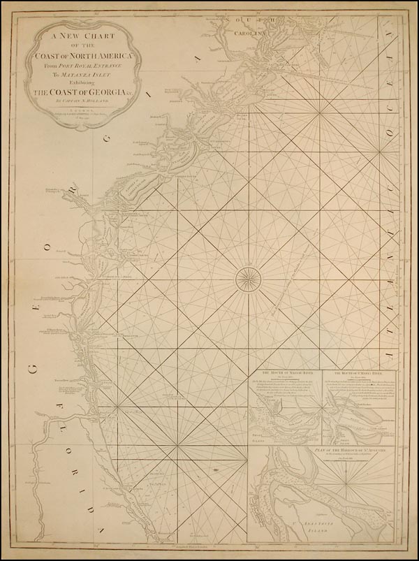 | |
| 44. | 1798 PRICE, Jonathan & STROTHER, John [Untitled Chart Of The Coast Of The Carolinas] TO NAVIGATORS / This Chart, / Being an actual SURVEY of the SEA COAST and inland Navigation / from CAPE HENRY to CAPE ROMAN is most respectfully inscribed by / Price & Strother. / Published agreeable to ACT of CONGRESS. / Engraved by W. Johnston NEW-BERN NORTH CAROLINA 1798. [1e] Jonathan Price & John Strother Separate publication New Bern, 1798 | 368 x 976 PM: 378 x 988 2 sheets joined Wheat & Brun, 590 |
| 45. | 1799: BRUN, Giovanni CARTE RÉDUITE / DES CÔTES ORIENTALES / DE L’AMÉRIQUE SEPTENTRIONALE / CONTENANT / Partie du Nouveau Jersey, la Pen-sylvanie, le Mary-land, la Virginie, / la Caroline Septentrionale, la Caroline Meridionale et la Georgie, / Assujettie aux Observations les plus récentes et aux Cartes de détail les plus / estimées, Dressée au Dépôt Général des Cartes, Plans et Journaux de la Marine. / AVERTISSEMENT / Gio. Brun Scupix in Roma 1799. [1a-c] From: Depot De La Marine ‘Neptune …’ Yves Gravier, Genoa [c.1800] | 573 x 847 PM: 577 x – |
| 46. | 1799 HEATHER, William A New Chart OF AMERICA with the Harbors of Port Royal, Savannah &c. Drawn from the latest Authorities, by W. Heather. 1799′ ‘Engraved by J. Stephenson.’ Inset: ‘THE ENTRANCE TO SAVANNAH RIVER’ [scale] ‘Scale of Miles’ – ‘5’ (58mm) [5b] 154 x 166 ‘PORT ROYAL’ [scale] ‘Scale of Miles’ – 8′ (50mm) [3b] 178 x 179 ‘CHARLESTON’ [scale] ‘Scale of Miles’ – ‘4’ (49mm) [4b] 184 x 178 ‘CAPE FEAR RIVER’ [scale] ‘Scale of Miles’ – ‘6’ (65mm) [4b] 188 x 223 From: Heather ‘The Marine Atlas Or Seaman’s Complete Pilot …’ London, 1808  | 638 x 1543 |