In the immediate aftermath of the Revolutionary War, one of the many problems faced by the new government was where to make its permanent seat, to be the capital of the new republic. Two cities, in particular, claimed the honour, New York and Philadelphia. However, neither city was sufficiently pre-eminent to claim the prize by right, and neither would give way to the other.
After much discussion, it was determined that a new city should be built, and an Act of Congress signed into law by Washington on 16th July 1790 enacted that a site on the Potomac River would become the new capital. Having chosen the site, Washington appointed an American engineer, Major Andrew Ellicott to survey and lay out the boundaries of the new Federal district. Ellicott received his instructions from Jefferson in a letter dated 2nd February 1791, and the course was completed by about September of the same year. It was intended that the plan should be published, but publication was not effected until 1794.
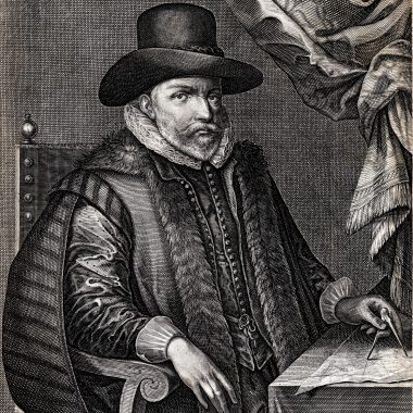
In the meantime, Washington appointed the French engineer Pierre Charles L’Enfant to survey the land designated for the city, and to produce a ground plan worthy of the new country, intended to be compared with any of the great European cities. To this end, Jefferson supplied L’Enfant with plans of several European cities, so that he could extract the best features of each.
However, while the survey work continued, L’Enfant proved a difficult character, exasperating both Washington and Jefferson with his headstrong approach to solving problems, and dealing with interests of individuals affected by his grand scheme. One problem was that part of the construction costs were to be met by selling parcels of land within the city boundaries, and yet the sales started before the ground plan had been completed, and the boundaries of these parcels of land properly established on the ground.
In the end, Washington lost patience with L’Enfant, who was dismissed in 1792. L’Enfant was replaced by Ellicott. However, in picque, L’Enfant refused to hand over any of his survey work, so Ellicott was forced to reconstruct the plan from his own working notes and recollections. Ellicott’s manuscript plan of the city is in the Library of Congress, although it is credited in the title to L’Enfant. It is thus difficult to know what parts of the finished plan is due to L’Enfant and how much credit is due to Ellicott.
Once the plan was completed, to general satisfaction, Ellicott was asked to arrange for its publication. Once a printed plan was in circulation, Washington and Jefferson felt it would be easier to encourage the necessary sale of land. Ellicott approached two engravers in Philadelphia, James Thackara and John Vallance, who agreed to engrave the plate. However, apparently for political reasons, the two men dallied on their commission. They originally promised delivery in eight weeks, but did not produce proofs until July, and completed impressions until November. While they may have been extremely dilatory in producing the full-size version, Thackara and Vallance were quick to engrave a small version of the plan, which takes precedence as the first printed plan of Washington, issued in the Universal Asylum And Columbian Museum in March 1792
Whether as a precaution or in frustration with the delay, Jefferson asked Samuel Blodgett Jr. to arrange to have a second version engraved. in May, Blodget employed Samuel Hill, a Boston engraver, to do the work. Hill also took the opportunity to engrave a smaller version for his own account, published in the Massachusetts Magazine, in May, but completed the folio plate by 25th June, when impressions were sent to Jefferson. The plate was sent to Washington in July, but miscarried, and mislaid until the middle of August. Hill’s plan was sent to a printer, and examples were in circulation for the second sale of land within the city, in October. The Thackara and Vallance plate was completed in November, and from then on examples were circulated widely, not only within the United States, but also in Europe, in the hope of stimulating overseas investment.
It is clear that the construction of Washington attracted widespread interest. With the two Philadelphia and two Boston maps (the “official” folio version and the smaller “pirate” version) acting as prototypes, a series of derivatives were issued, ranging from New York to London, Amsterdam, Gotha and Vienna.
The, in 1800, when Washington officially became capital, two commemorative plans were issued printed on cloth, again drawing on Ellicott’s work, but printed from plates specially prepared for the occasion.
References:
This short note, and checklist, are based on Coolie Verner. Surveying and mapping the new Federal City: the first printed maps of Washington, DC (Imago Mundi, XXIII, 1969), p.59ff), where more detail is given about the background to the construction of Washington, L’Enfant’s survey work, and relations with the
Further background is given in Nelson R. Burr, The Federal City Depicted 1612 – 1801, in Walter Ristow (ed.) A La Carte Selected Papers on Maps and Atlases (Washington, Library of Congress, 1972), p.126ff.
CHECKLIST
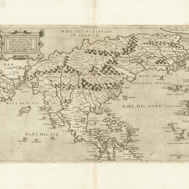
| * | ELLICOTT’S MANUSCRIPT DRAUGHT[1792]: [ANDREW ELLICOTT] PLAN of the CITY, intended for the Permanent SEAT of the Governement of the UNITED STATES. Projected agreeable to the direction of the PRESIDENT of the UNITED STATES, in pursuance of an ACT of CONGRESS passed the sixteenth day of July, MDCCXC, “establishing the Permanent Seat on the bank of the Potowmack” By Peter Charles L’Enfant’Scale: ‘SCALE OF POLES’ – ‘560’Location: Library Of Congress | Manuscript, 1000 x 720Verner, p.64-5 & p.65 (detail of the title); Reps: The Making of Urban America, fig.148, the manuscript attributed to L’Enfant. |
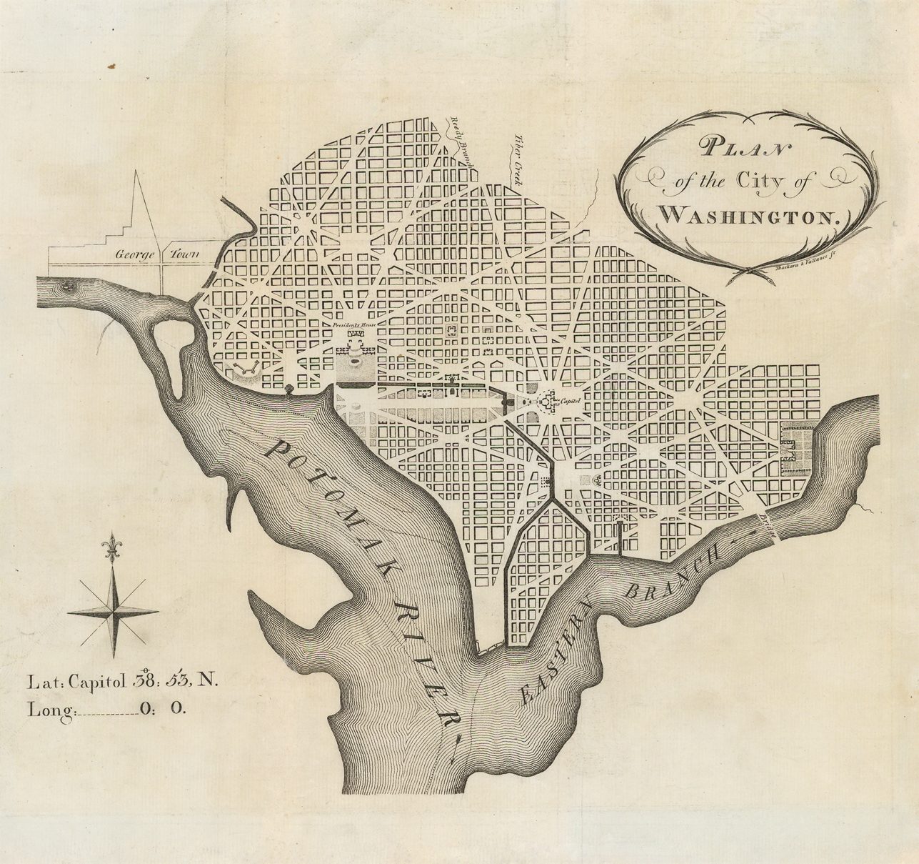
| 1. | [1792]: James THACKARA & John VALLANCE PLAN / of the City of / WASHINGTON. [4b] Thackara & Vallance sc. [4b, under the title]Scale: [not given]Thackara & Vallance Separate Publication, [Philadelphia, March, 1792]From: ‘The Universal Asylum And Columbian Magazine’, opposite p.155, Philadelphia, March 1792From: [Tobias Lear] ‘Observations On The River Potomack’ New York, 1793, and Second Edition, New York, 1794 | 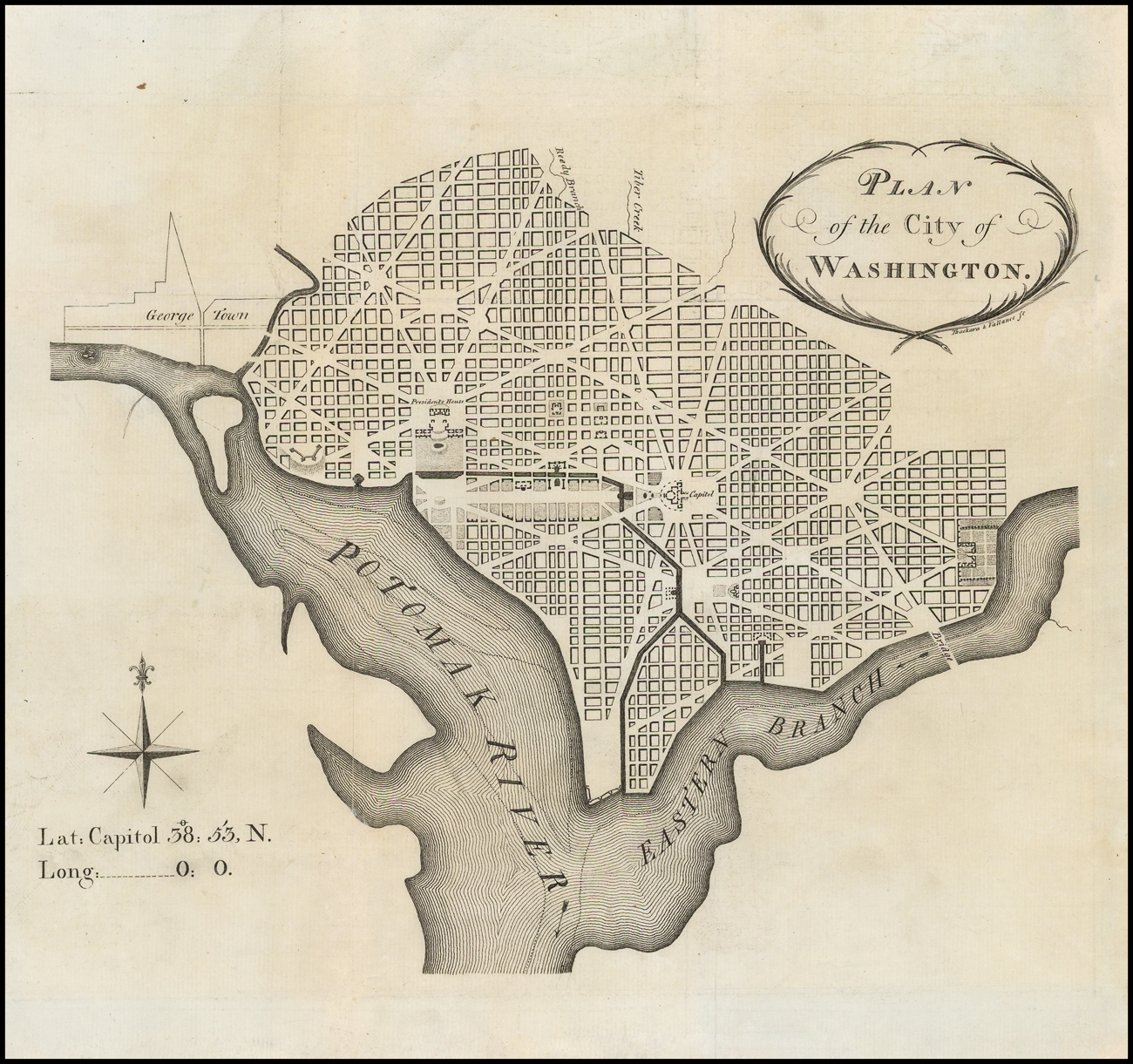 Image: 210 x 260 PM: 226 x 302mm.Verner, 1; Wheat & Brun, 527; |
| 2. | 1792: HILL, Samuel PLAN / of the City of / WASHINGTON. [4b] S. Hill. Boston. [4b, under title] Massa. Mag. 1792. [2b]Scale: [not given]From: ‘The Massachusetts Magazine’ opposite p.[284], Boston, 1792 | 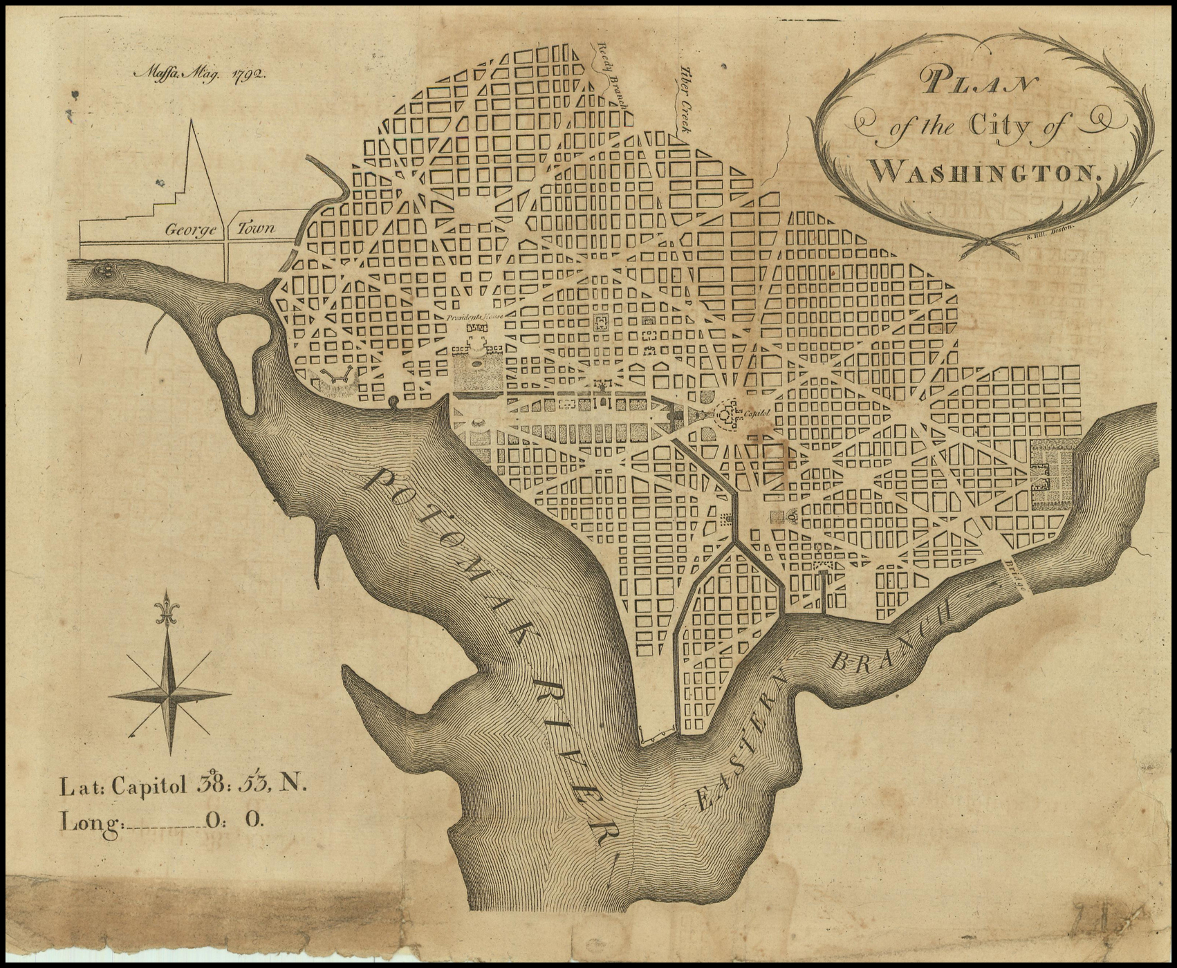 Image: 204 x 253mm.Verner, 2; Wheat & Brun, 528. |
| 3. | [1792]: TIEBOUT, Cornelius PLAN / of the City of / WASHINGTON. [5b] Tiebout. [5b, below the title] N. York Mag. [2b]Scale: [not given]From: ‘The New York Magazine Or Literary Repository’ vol. 3, Part VII, opposite p.322, New York, June 1792 | 203 x 266mm.Verner, 3; Wheat & Brun, 529. |
| 4a. | “THE BOSTON PLAN”[1792]: HILL, Samuel: state 1 PLAN / of the City of / Washington / in the Territory of Columbia. / ceded by the States of / VIRGINIA and MARYLAND / to the United States of America, / and by them established as the / SEAT of their GOVERNMENT, / after the Year / MDCCC. / [rule] / Engrav’d by Sam.l Hill Boston. [2b]Scale: ‘SCALE OF POLES’ – ‘600 Poles’ or ‘6 Inches’ (139 mm) [1d]Separate Publication, proof , Boston [June / July 1792]Separate Publication, [Robert Scott, Philadelphia, September 1792], price 2s. 6d. | 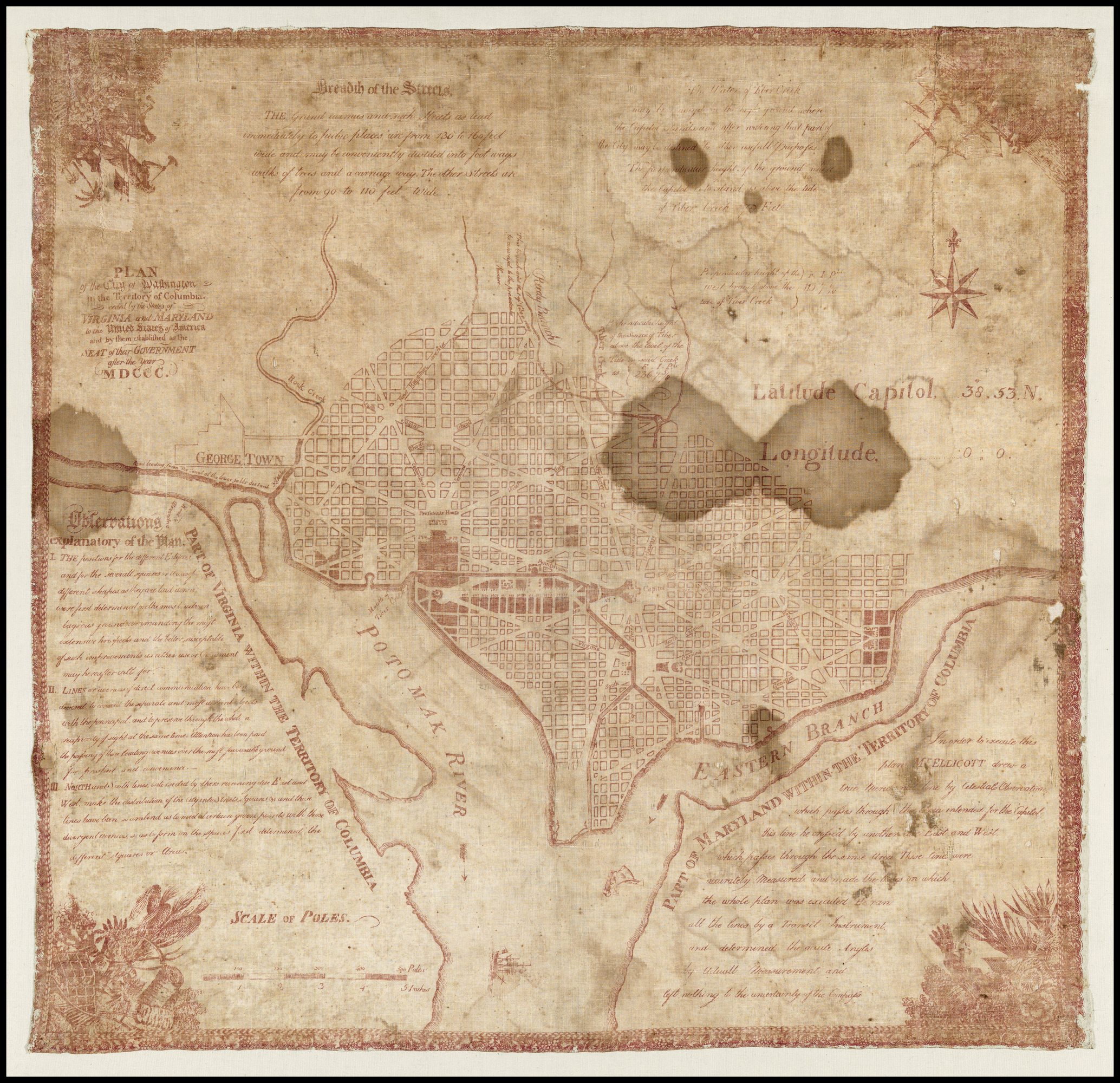 PM:402 x 498Source: Based on a version of the original manuscript draught.The engraving apparently cost $150.00. State 1: the proof was apparently without soundings either in the Potomac, or its branch. This omission is noted in two letters from Washington, in which he asked that soundings be inserted, although they apparently never were.Advertisements in ‘Dunlap’s American Daily Advertiser’ and ‘The Gazette of the United States’ for September 15th 1792, apparently refer to both this and the Thackara and Vallance plan.Verner, 4; Wheat & Brun, 530; Stokes & Haskell, (1792) B-114; |
| 5a. | ‘THE PHILADELPHIA PLAN'[1792]: THACKARA, James & John VALLANCE state 1 PLAN / of the CITY of / Washington / in the Territory of Columbia, / ceded by the States of / VIRGINIA and MARYLAND / to the / United States OF America, / and by them established as the / SEAT of their GOVERNMENT, / after the Year MDCCC. / [rule] / Engrav’d by Thackara & Vallance Philad.a 1792. [4b]Scale: ‘SCALE OF POLES’ – ‘600 Poles’ (141mm) / ‘6 Inches’ (141 mm) [2e]Separate publication, proof Philadelphia, [June / July 1792] | 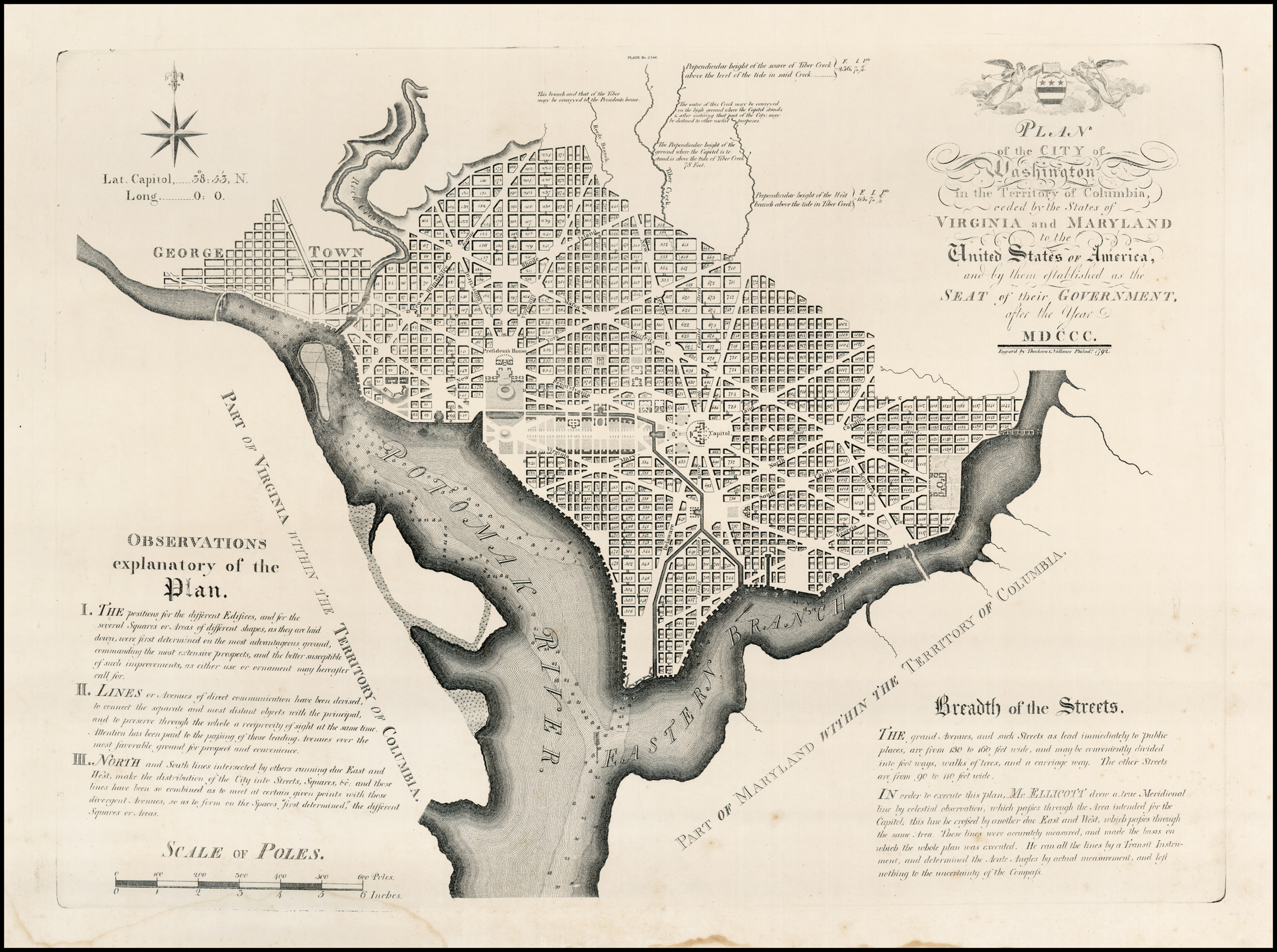 Image: 510 x 667 PM: approx. 515 x 685mmSource: Based on a version of the original manuscript draught.The engraving apparently cost $420.00. |
| 5b | [1792]: THACKARA, James & John VALLANCE state 2 PLAN / of the CITY of / Washington / in the Territory of Columbia, / ceded by the States of / VIRGINIA and MARYLAND / to the / United States OF America, / and by them established as the / SEAT of their GOVERNMENT, / after the Year MDCCC. / [rule] / Engrav’d by Thackara & Vallance Philad.a 1792. [4b]Scale: ‘SCALE OF POLES’ – ‘600 Poles’ (141mm) / ‘6 Inches’ (141 mm) [2e]Separate Publication Philadelphia [November] 1792, price 4s 8 1/2d. | State 2: with the addition of the soundings, as requested by Washington.Advertisements in ‘Dunlap’s American Daily Advertiser’ and ‘The Gazette of the United States’ for September 15th 1792, apparently refer to both this and the Samuel Hill plan.Verner, 5; Wheat & Brun, 531. |
| 6. | [1792]: WINCHESTER, Elhahan PLAN / of the City of / WASHINGTON. [4b, without cartouche]Scale: [not given]From: Winchester ‘An Oration On The Discovery Of America. Delivered In London, October The 12th. 1792, Being Three Hundred Years From The Day On Which Columbus Landed In The New World. [rule] The Second Edition, With An Appendix Containing Among Other Things, A Description Of The City Of Washington, In The District Of Columbia, Illustrated With An Accurate Engraving … ‘ London, [1792] | Image: 215 x 253mm.The key is printed on the facing page.Source: ‘The Boston Plan”Verner, 6. |
| 7. | 1793: GOOD, J. PLAN / of the City of / WASHINGTON. [4a] Published as the Act directs Feb. 1, 1793 for the Proprietors by I. Good Bond Street. [3e, ob] Literary Magazine. [5e]Scale: [not given]From: ‘The Literary Magazine And British Review’ p.49, London, January 1793 | Plan: 214 x 258 Image: 228 x 258 PM: 242 x 294Source: The small Thackara & Vallance plan (no.1).Verner, 7; Phillips, Maps, p.1004. |
| 8. | 1793: BAKER, Benjamin PLAN / OF THE CITY OF / WASHINGTON; / NOW BUILDING FOR THE / METROPOLIS OF AMERICA, / AND ESTABLISHED AS THE / PERMANENT RESIDENCE OF / CONGRESS / AFTER THE YEAR / 1800. [4b] B. Baker sculp. Islington. [5e, ob] Published by W. Bent 1793. [1e, ob]Scale: ‘Scale of 2 Miles’ – ‘2’ [4d]From: ‘The Universal Magazine’ vol.93, opp. p.41, London, July 1793[accompanying text, pages 41-43] ‘A DESCRIPTION of the Situation and Plan of the CITY of WASHINGTON / in the District of Columbia, in North America, now Building for the / METROPOLIS of the UNITED STATES. / …’ (the text is apparently based on that in the London Magazine’) | 273 x 343 Platemark: 296 x 366Source: ‘The Philadelphia Plan’Verner, 8; Jolly: Maps in British Periodicals, 442; Phillips: Maps, p.1004. |
| 9. | [1793]: ANONYMOUS PLAN / DER STAD / WASHINGTON, / BESTEMD TOT DE HOOFSTAD / VAN AMERICA, / EN TER BESTENDIGE VERBLIJFPLAATS / VAN HET CONGRES, / NA HET JAAR / 1800. [4b]Scale: ‘Schaal Van 2 Mijlen’ – ‘2’ (95mm)From: [Anonymous] ‘Algemeene Vaderlandsche Letter-Oefeningen, Waarin De Boeken En Schriften … Voor 1793 …’ A. van der Kroe & J. Yntema, Amsterdam, 1793 | 265 x 333 PM: 298 x 363Source: Benjamin Baker’s Plan, No. 8.Verner, 9. |
| 10a. | 1794: STOCKDALE, John state 1 PLAN / of the CITY of / WASHINGTON. [1d] Published by J. Stockdale Piccadilly 16.th Sep.r 1794. [3e, ob]Scale: ‘Statute Miles’ – ‘1’From: [Jedidiah Morse] ‘Maps Of America To Accompany The American Geography …’, John Stockdale, London, 1794From: [Jedidiah Morse] ‘The American Geography …’ John Stockdale, London, 1794 | 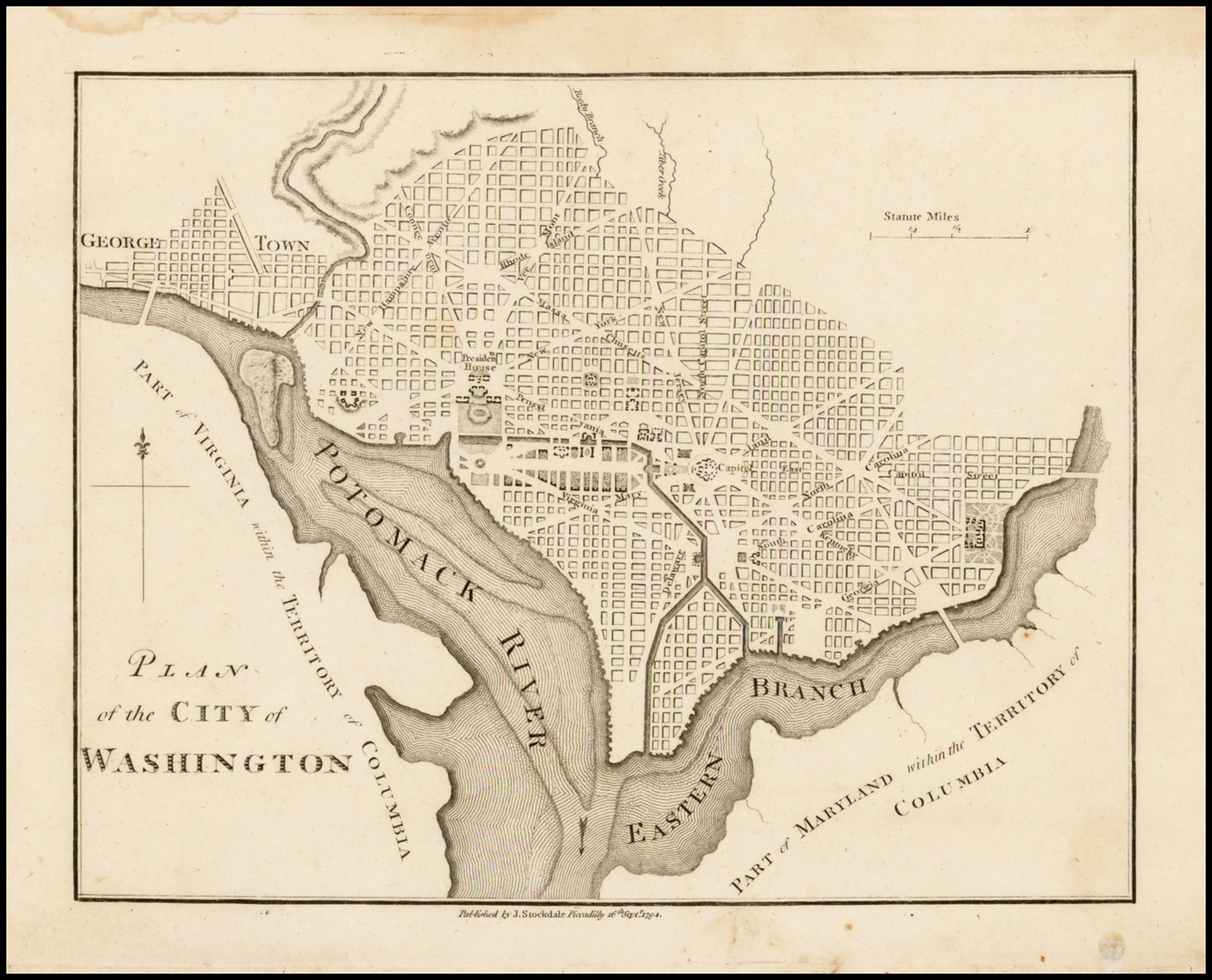 Map: 168 x 213Source: ‘The Philadelphia Plan’Verner, 10; Phillips: Maps p.1005. |
| 10b. | 1794-1798: STOCKDALE, John state 2 PLAN / of the CITY of / WASHINGTON. [1d] Published by J. Stockdale Piccadilly 16.th Sep.r 1798. [3e, ob]From: Isaac Weld ‘Travels Through The States Of North America …’ John Stockdale, London, 1799 (later editions: 1799, 1800, 1810) | 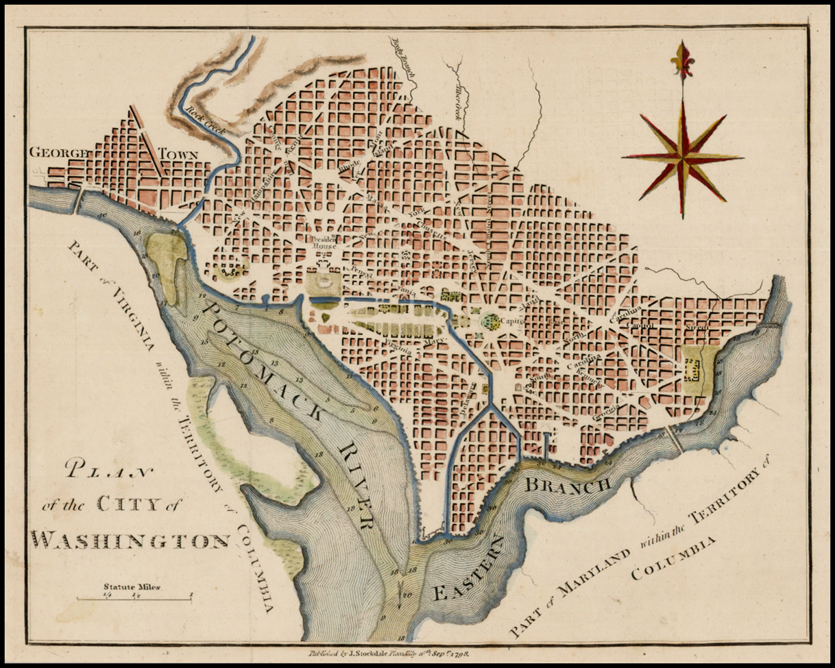 another state: with the imprint now dated 1798.Verner, 14 (not noticing the connection); Phillips, Maps, p.1006 (not noticing the connection); Burr, p.141. |
| 11. | 1794: WEIDNER Jr. & J.G. KLINGER PLAN / de la ville / de / WASHINGTON / en / Amérique. [4a] Weidner, Jun. del. [1e, ob] J.G. Klinger, sc. Nor. / 1794. [5e, ob][scale] – ‘2’ [4e]From: ‘Almanac De Gotha Pour L’Annee 1795 …’ C.W. Ettinger, Gotha, [1794]From: ‘Gothaischer Hof-Kalendar …’, Gotha, [1794] | 159 x 199mm.Verner, 11; Phillips: Maps, p.1005: Gothaischer. |
| 12. | [1794]: WEIDNER Jr. PLAN, / de la ville / de / WASHINGTON / en / Amérique. [4a] Weidner jun. del. [1e, ob][Scale] – ‘2’ [4e]From: ‘Almanac De Gotha Pour L’Annee 1795 …’ C.W. ETTINGER, Gotha, [1794] | 160 x 200mm.A second version of the plan, from a newly engraved plate; the engraved title-page and frontispiece of the Almanack are from new plates also.Not in Verner; |
| 13a. | [1795]: REID, John state 1 PLAN / of the CITY of / Washington / in the Terrritory of Columbia / ceded by the States of / VIRGINIA AND MARYLAND / to the / United States of America / and by them established as the / SEAT of their GOVERNMENT, / after the YEAR / 1800. / Rollinson sculp.t N. York. [1d] Publish’d by I. Reid L. Wayland and C. Smith 1795. [2d, under title]Scale: ‘SCALE OF POLES’ / – ‘600 poles’ / – ‘6 Inches’ [4d]From: Reid ‘The American Atlas …’ New York, 1795From: Reid ‘The Atlas For Winterbotham’s History Of America …’ New York, 1796From: Winterbotham ‘An Historical, Geographical, Commercial, And Philosophical View Of The United States Of America …’ New York, 1796 | 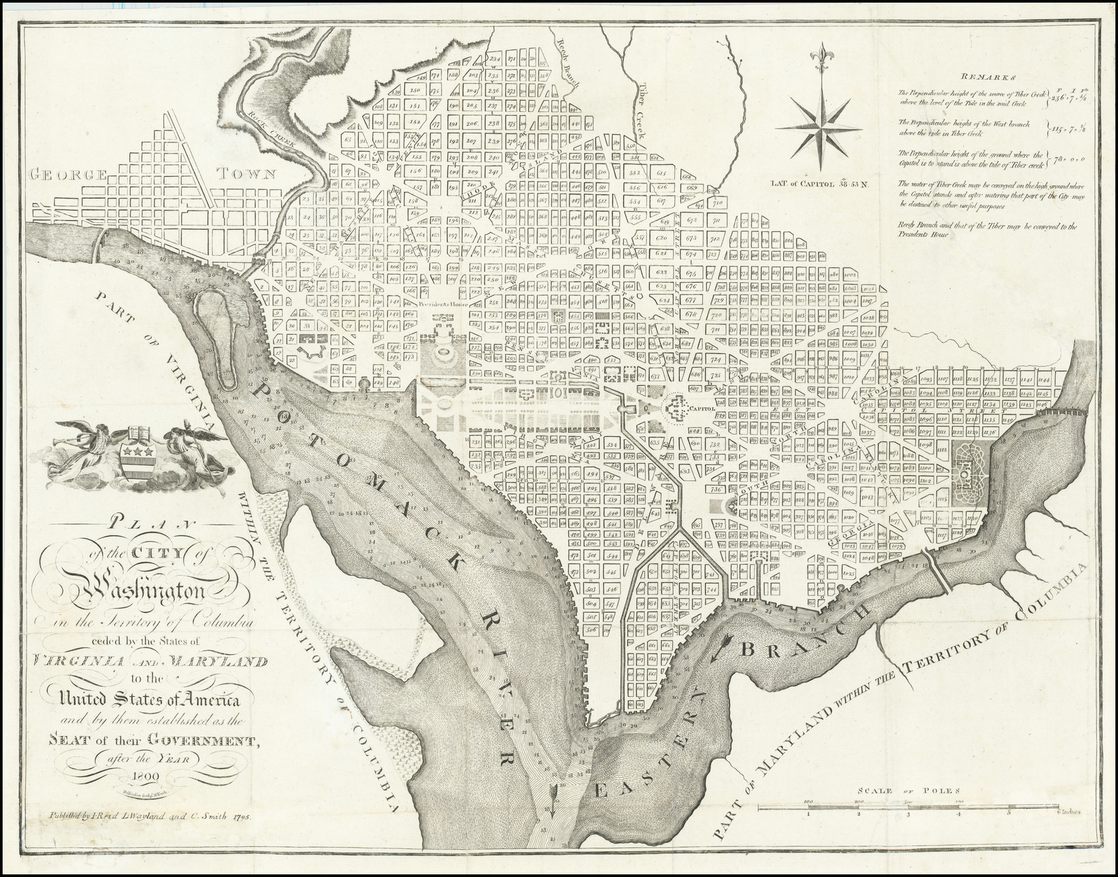 402 x 523mm.Source: ‘The Philadelphia Plan’.The plan was engraved by William Rollinson.Verner, 12: State 1; Wheat & Brun, 537; Phillips: Maps p.1005.Locations: Atlas 1: Wheat & Brun R 382;Atlas 2: Wheat & Brun R 383;Atlas 3: Wheat & Brun R 533. |
| 13b. | [1795-1796]: REID, John state 2 PLAN / of the CITY of / Washington / in the Terrritory of Columbia / ceded by the States of / VIRGINIA AND MARYLAND / to the / United States of America / and by them established as the / SEAT of their GOVERNMENT, / after the YEAR / 1800. [2d] Rollinson sculp.t N. York. [2d, under title] Publish’d by I. Reid. [2d, under title]From: John Reid ‘The American Atlas …’, New York, 1796 | 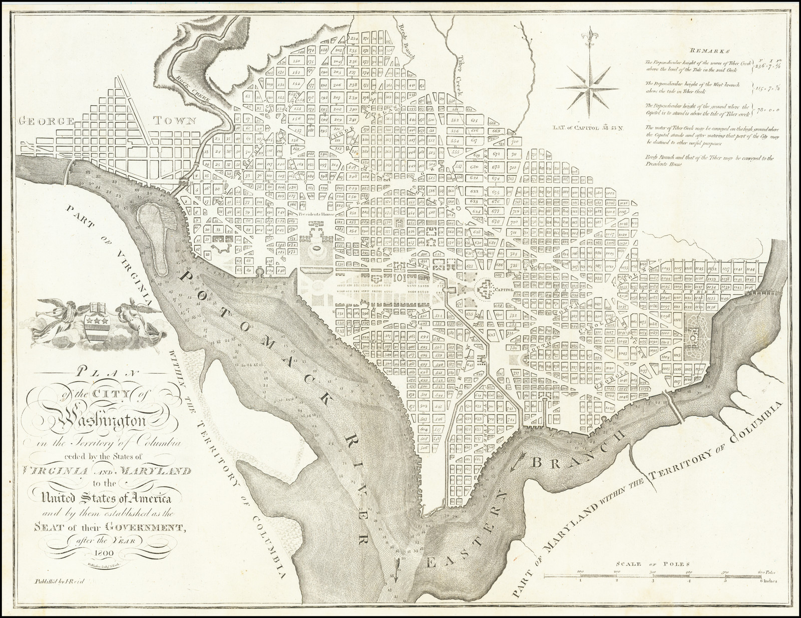 State 2: The imprint has been altered by deleting the names of Wayland and Smith, along with the date.Verner, 12: State 2; Wheat & Brun, 538; Phillips: Maps, p.1005. |
| 14. | [1795]: RUSSELL, John PLAN / of the CITY of / Washington, / in the Territory of Columbia, / ceded by the States of / VIRGINIA AND MARYLAND / to the / United States of America, / and by them established as the / SEAT of their GOVERNMENT, / after the YEAR / 1800. [1d] J. Russell sculp.t Constitu:n Row, Grays Inn Road. [1d]Scale: ‘SCALE OF POLES’ – ‘600 Poles’ or ‘6 Inches’ (149mm) [4d]Separate Publication, [London, 1795]From: [John Reid] ‘The American Atlas …’ H.D. Symonds & J. Ridgeway, London, 1795 | 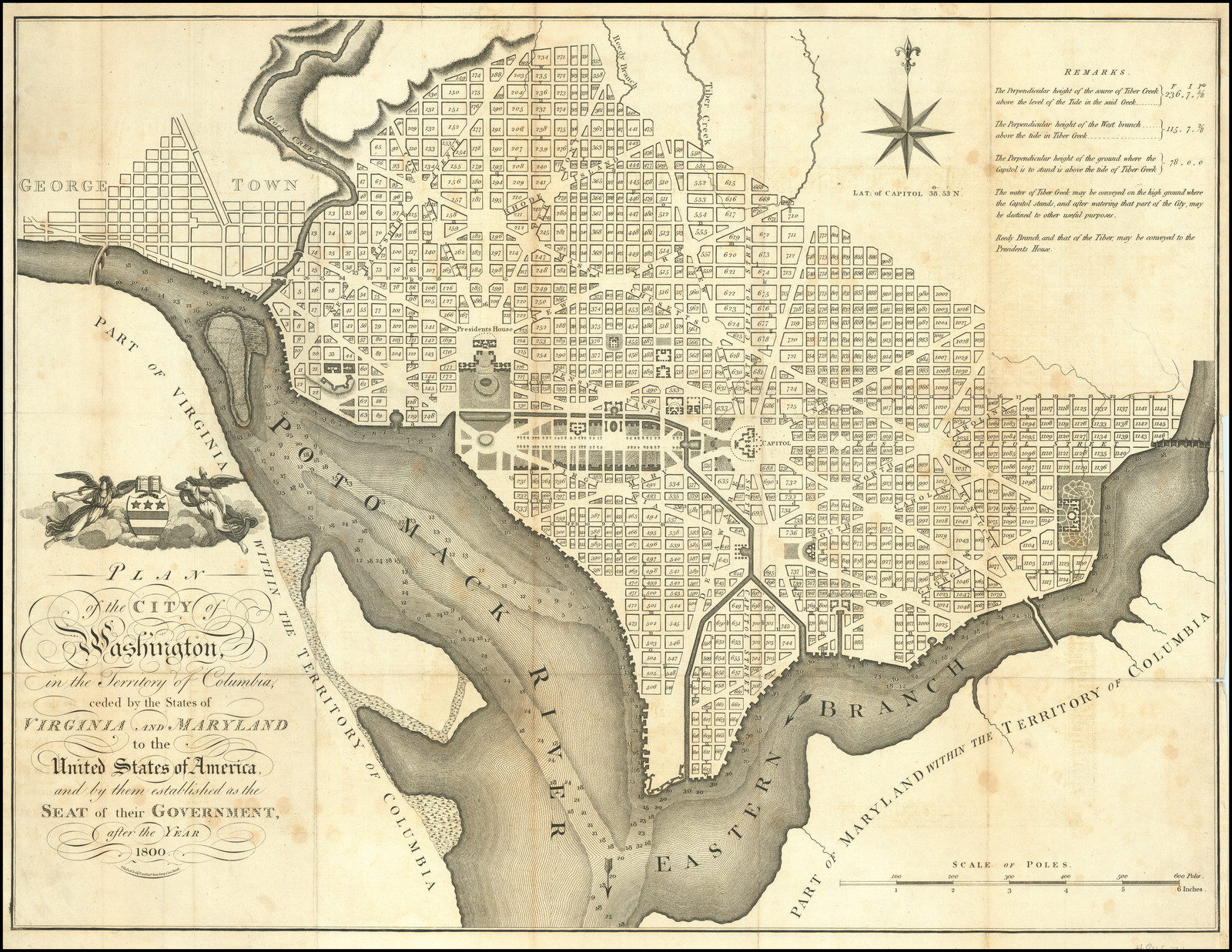 401 x 528mm.Source: Reid’s plan;Verner, 13; Phillips: Maps, p.1005; Ristow: American Maps, p.153. |
| 15. | 1796: JUNCKER, C. PLAN / der Stadt / WASHINGTON / in AMERICA. [4b] C. Juncker sc. Viennæ. [5e, ob] Beilage zur Grätzer Zeitung, 1796. [4e-5e] Scale: [miles] – ‘2’ [4d]From: [?] | 440 x 480mm. |
| 16. | [1800]: ANONYMOUS ‘PLAN of the CITY of WASHINGTON.’ ‘nach dem Englischen Original gestochen von Carl Jattnig in Berlin.’Scale: From: [Isaac Weld] ‘Isaac Weld’s Des Jungern Reisen Durch Die Staaten Von Nordamerika, Und Die Povinzen Ober- Und Nieder-Canada, Wahrend Den Jahren 1795, 1796 Und 1797. Aus Dem Englischen Ubersetzt. Mit Kupfern …’ Berlin, 1800 | 166 x 212mm.Source: Stockdale’s plan of 1794.Nordenskiold Collection, III, .716, [4]; not in Verner. |
| 17. | PRINTED ON CLOTH[1800 ?]: ANONYMOUS PLAN / of the City of Washington / in the Territory of Columbia. / ceded by the States of / VIRGINIA and MARYLAND / to the United States of America / and by them established as the / SEAT of their GOVERNMENT / after the Year / MDCCC. [2b]Scale: ‘SCALE OF POLES’ – ‘500 Poles’ or ‘5 Inches’ (124mm) [2d]Separate Publication [December, 1800 ?] | Source: a copy of the ‘Boston Plan’, although not printed from the actual plate.Medium: Copperplate Engraving, printed on cloth, with blue ink.Inner border: 578 x 598; widest surviving: 610 x 640Verner, 15; Wheat & Brun, 532; Burr, p.137 (ill: printed in red ink). |
| 18 | PRINTED ON CLOTH[1800 ?]: ANONYMOUS PLAN / of the City of / WASHINGTON, / in the Territory of Columbia, / ceded by the States of / VIRGINIA and MARYLAND / to the United States of America, / and by them established as the / SEAT of their GOVERNMENT / after the Year / M D CCC. [4b] JW sculpsit.Inset: [Oval Portrait] ‘George Washington President of the United States’Scale: ‘SCALE OF POLES’ – ‘600’Separate Publication [December, 1800 ?] | 550 x 610mm.Source: ‘The Philadelphia Plan’, though not printed from the original plate.Medium: Copperplate Engraving, Printed On Cloth, With Red InkVerner, 16; Wheat & Brun, 533. |
| 19. | PLANS OF WASHINGTON NOT LOCATED:[1792: DUNLAP, John] [Plan of the City intended for the Permanent Seat of Government of the United States, projected agreeable to the direction of the President of the United States, in pursuance of an Act of Congress, passed on the 16th of July, 1790 “establishing the permanent seat on the banks of the Potowmack” By Peter Charles L’Enfant. Philadelphia: Printed by John Dunlap, 1792]Scale: [not known]Separate Publication ?Location: no known examples | Size: [not known]The title, as given, clearly relates to the original manuscript, produced by Andrew Ellicott, but no printed versions are known with the imprint of Dunlap.There are three possible, but speculative, explanations for this item:1: That Dunlap intended to produce such a map, but failed to accomplish this intention.2: That the map was completed and published, but no examples are recorded.3: That this reference refers to the Thackara and Vallance plan. Both men were engravers, rather than printers, and the printer of their plan (if they did not do it) is unknown. Against this possibility, is the absence of Dunlap’s name on the map.If Thackara and Vallance were sub-contracting the actual printing, this might provide a more reasonable explanation of the delay in their completing the project.Both the Thackara and Vallance and Hill plans were advertised in ‘Dunlap’s American Daily Advertiser’ in September 1792, by a number of booksellers in Philadelphia (though not John Dunlap) and this may be a cause of confusion.Wheat & Brun, 534: based on Evan, 24471. |
| 20. | PLANS OF WASHINGTON NOT LOCATED[1796: Thomas FREEMAN] [A Plan of the City of Washington. By Thomas Freeman, Surveyor of the Territory of Columbia and City of Washington.]Scale: [not known]Separate Publication ?Location: no recorded examples | Size: [not known]Apparently, Freeman issued proposals, in June 1796, for a plan of Washington, but no example is known.Wheat & Brun, 536: based on Evans, 30452. |