The following check-list comprises printed charts of the New England region, or general charts of the eastern seaboard of North America, published between 1646 and 1785. Omitted are charts of the North Atlantic, and detailed charts of part of the coast, and individual harbours, particularly for example, from the des Barres’ Atlantic Neptune.
The earliest printed charts of the region are found in Sir Robert Dudley’s Dell’Arcano dell’Mare‘, one of the landmarks in the history of cartography. It was the first printed sea-atlas encompassing the whole world, with all the charts prepared on Mercator’s Projection (itself designed for use by seamen), with lines of latitude and longitude clearly marked.
Referring to the manuscript chart of Florida, Kohl wrote: “The observations on the wind and currents are particularly remarkable. Dudley introduced such observations on all his charts, at a time when nobody else thought of it”. (1) It is this deep-rooted scientific approach that forms the heart of Dudley’s work.
Cavendish, the navigator, so it was probably inevitable that he would go to sea. He saw service with the English fleet in operations against the Spanish in Guiana, and against Cadiz, and in the meantime received an extensive training in navigation, at which he became extremely proficient. Unfortunately, what promised to be a distinguished naval career was curtailed early. His role in court intrigues, as he attempted to secure his father’s titles for himself, earned him the queen’s disfavour, and in 1605 he was forced into exile, eventually settling in Florence.
There, under the patronage of Cosmo II and then Ferdinand II, Dudley devoted himself to maritime studies, compiling treatises on navigation and ship-building, as well as an atlas of manuscript charts, completed by about 1636, preserved in the Royal Library in Munich. which formed the basis for his printed charts.
The sources employed by Dudley are difficult to reconstruct. There is evidence on certain charts of information drawn from personal experience, but the vast majority of the charts must have relied on manuscript materials supplied by his family and friends in England, from Dutch contacts, or gathered, by personal contact or through the offices of his patron, from Italian and Spanish sources. Unfortunately, such an archive as Dudley might have compiled no longer exists, although Stokes notes the existence of six manuscript portolan charts of this period, by an English map-maker John Daniel, preserved in the Bibliotheca Palatina in Florence which may be one small part of a much more extensive collection, once owned and used by Dudley. (2)
Although the manuscript atlas was completed by about 1636, the printed atlas was not completed until 1648 – the engraver Lucini himself writing that he had spent twelve years on engraving the charts. Later writers have been very critical of Dudley the chart-maker, but considering the period in which he was working, the constraints imposed by his exile, and the weaknesses of his source material, Dudley’s charts represent an enormous scientific achievement, not challenged in approach until the advent of the quasi-official English and French ‘Admiralty’ surveys of the middle and late eighteenth centuries.
Dudley’s first chart is found in a preliminary section of large scale charts, while the second chart, ‘Nuoua Belgia’, is placed within the sequence of maps of the American coasts, and depicts a smaller area. (3) A comparison of this map with its companion reveals widely divergent detail, pointing to Dudley’s use of quite different sources for the two maps.
One of the problems often faced by map-makers who worked at second-hand was this very problem of trying to evaluate two different sources, without relevant first hand experience. Often, as is possible here, the map-maker offered both alternatives, in different maps, so that at least the navigator might have the luxury of a choice.
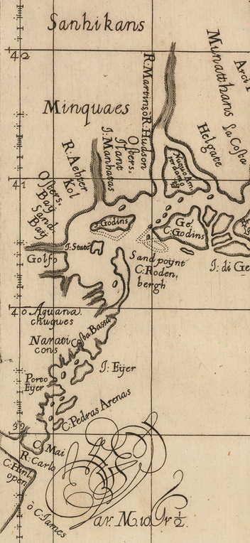
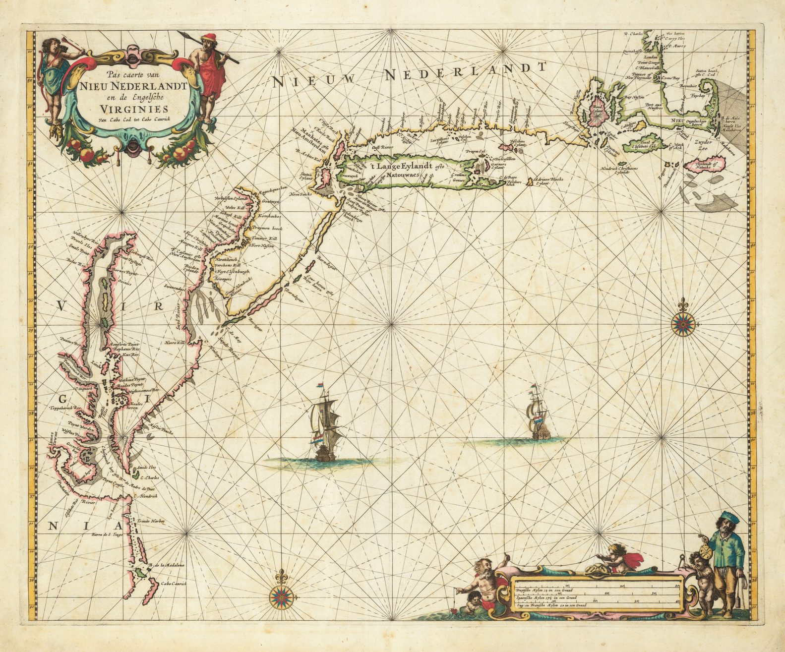
On the ‘Nuoua Belgia’, the toponomy of the southern New England coastline seems to point to a Dutch source, which named ‘Nuoua Amstrdamo’ (on Manhattan Island) ‘Rio Martin o R. Hudson’ ‘I: State[n].’ (albeit an the wrong island), and two forms of Manhattan: ‘Minatthans’, and ‘I. Manhatas’, both misplaced. Stokes believed the reference to Staten Island to be the first appearance of the name in a printed map. (4)
As Stokes pointed out the outline bears considerable resemblance to Block manuscript map of the region, drawn in 1614, as published by Willem Blaeu in his ‘NOVA BELGICA ET ANGLIA NOVA’ (Amsterdam, 1635), which was a land-map, rather than sea-chart.(5) There are other examples from within this sequence of information from land-maps being absorbed by chart-makers.
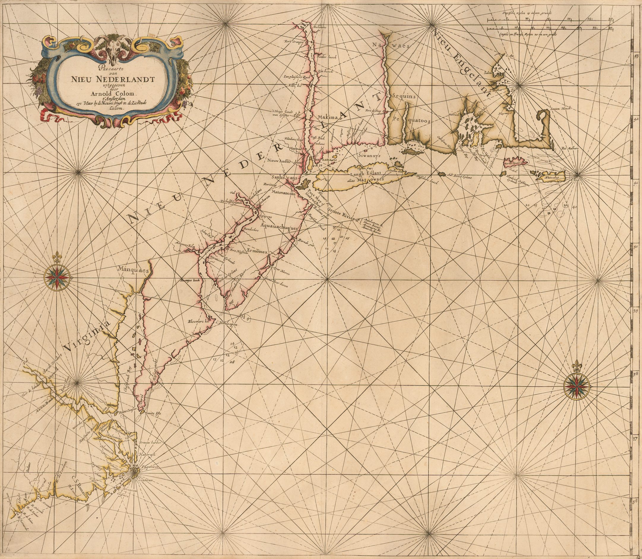
The first Dutch chart of the New Netherlands was prepared by Jacob Theunisz, who died in 1650, although the chart does not seem to have received wide circulation until the 1670’s. Arnold Colom’s chart of the region, which was described by Koeman as the first printed “chart of what was called ‘Nieu Nederland'” (6), seems to have proved more popular, and its influence can be seen running through the sequence of general charts of the eastern seaboard published by successive Dutch chart-makers. This map, and its companions in ‘Zee-Atlas’ are notable for their size, being engraved on a much larger format than was generally used, both in preceding and subsequent Dutch atlases.
A reference to the plates from this atlas is found in a Notary Act of 1663, ordering Colom to give them to his landlord Nicolaas Visscher (a prominent map-maker, also) as security against his unpaid rent.(7) Presumably, the debt was never paid, as no subsequent issues by Colom are known. It would appear that on the death of Colom, Visscher, who had no interest in publishing sea-atlases, sold the plates to Hendrick Doncker, because some of the plates subsequently re-appear in his ‘Vermeerderde Zee-Atlas’, from 1676 onwards.
Although Jacob Colom, Arnold’s father, had been publishing pilot-books with charts in for many years, Arnold was the first to publish a sea-atlas, and subsequently Jacob initiated his own, first published in 1663, essentially based on his son’s chart, but with new information in the New York region. A further member of the family also made a foray into chart-publishing. Pieter van Alphen was introduced to the profession on his marriage to Joanna Colom, daughter of Jacob and brother of Arnold, in 1657. With their support, Alphen published his first atlas in 1660.
Koeman wrote:
“The importance of this atlas is based on the fact that it exclusively consists of charts, used for navigation beyond coastal waters. The charts of the oceans are all drawn on the Mercator projection.”
Koeman, do, p.15: Alp 1, notes.
Hendrick Doncker was one of the most prolific and successful chart-makers in Amsterdam in the seventeenth century, issuing many different pilot-guides and sea-atlas collections. His earliest maps reflect very much Colon’s earlier work, but in contrast with many of the other publishers in this catalogue, Doncker worked hard to keep abreast of the latest discoveries, improving or replacing exiating plates, as necessary.
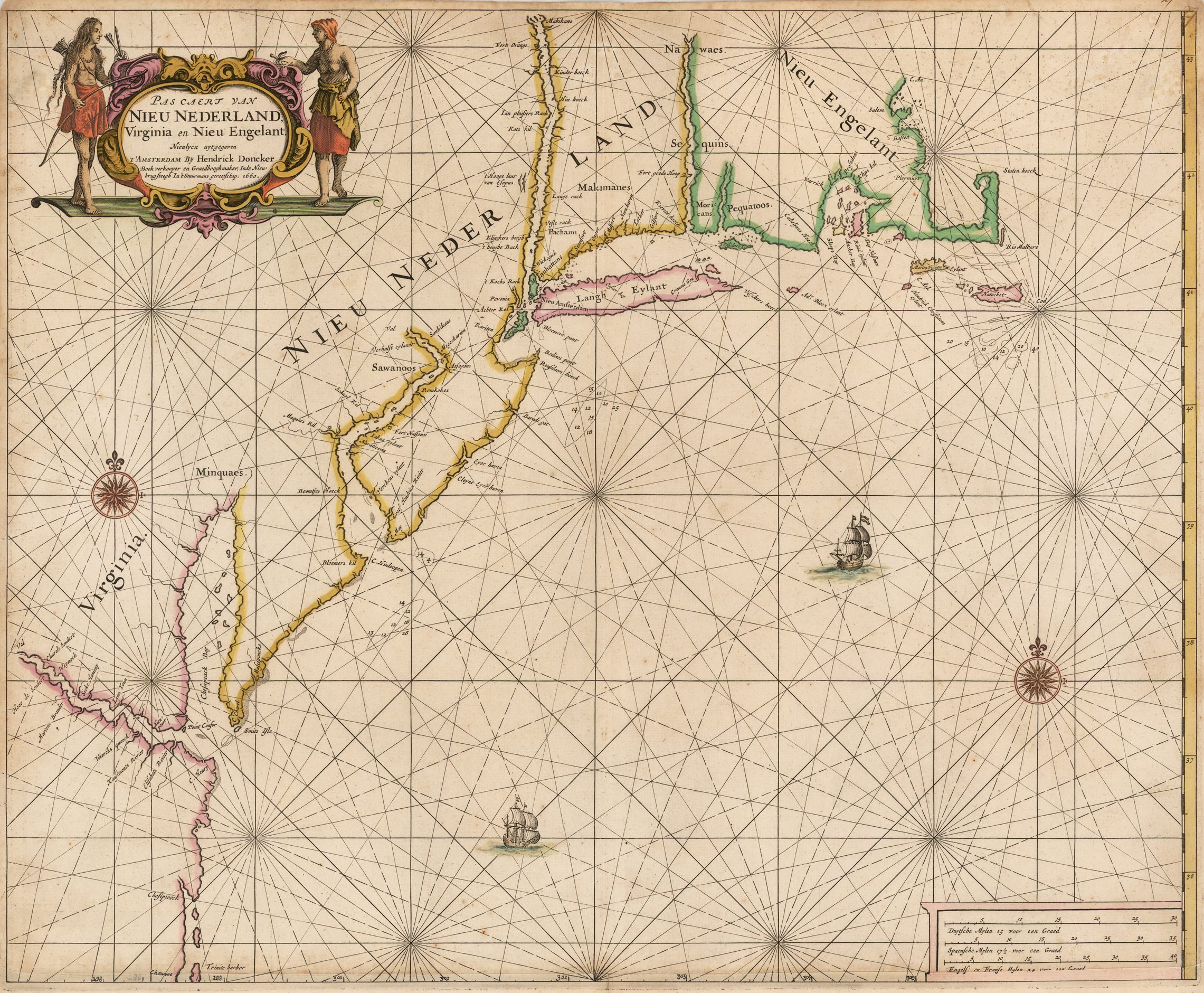
His chart of the ‘Nieu Nederland’ is a derivative of Colom’s chart, with a very similar delineation of the coast north of Chesapeake Bay, albeit with omissions of toponymy. One noticeable variation is the much rounder shape of the New Jersey coast of New York harbour. The delineation of North Carolina, is much inferior, returning to an earlier model for the Cape Hattoras banks.
In about 1672 Doncker announced his intention of producing a large-folio sea-atlas, comparable with that of Arnold Colom, in fact utilising Colon’s original plates. This plate had Doncker’s name substituted for Colom’s in about 1675, for it was then that he started using the detailed address (“the third house down from the New Bridge”), to distinguish his shop from that of a rival ships-chandler, Johannes van Keulen, who had moved into the street opposite him. (9)
This new sea-atlas, De Nieuwe Groote Vermeerderde Zee-Atlas, was published from 1676 onwards. However, both extant copies with the title-page dated 1675 are editions of the standard atlas in all other respects.
One of the problems often associated with over-size atlases was the risk of cropping the maps in binding. It is presumably for this reason that for the 1688 edition (and perhaps as early as 1675) many of these large plates were cut down to a more standard size, as was the New England chart, but in the only example of this edition of the atlas recorded by Koeman, the map has been superceded by a new plate with an inset of Philadelphia.
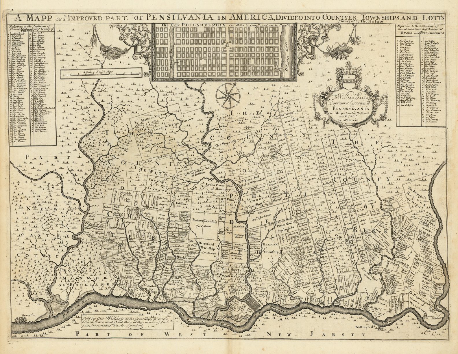
The foundation of Philadelphia proved a particularly influential event in cartographic history. Within a short space of time, Thomas Holme’s town plan was copied and re-issued by numbers of European map-makers. Obviously, Doncker took the opportunity to prepare a new sea-chart of New England, incorporating Holme’s plan as an inset.
This chart was subsequently re-issued by Gerard van Keulen. According to Koeman, Hendrick Doncker Jr. sold substantial parts of the business stock to Johannes van Keulen, after 1700.(10) However, two advertisements in the Amsterdamse Courant, for November 23rd and December 13th 1720, show Hendrick Doncker’s widow advertising for sale the shop in ‘de Nieuwenbrugsteeg’ with the shop-wares – “bestaende in Kaerten, Boecken, &c. en alle soorten van Stuurmans Gereedschappen.” It is more plausible that this plate was acquired by van Keulen at this later time.
Then, just as the foundation of Philadelphia provided the impetus for the original plate, so the publication of Halley’s chart of Boston harbour proved the spur that caused Gerard van Keulen to re-engrave the plate, adding the new inset of Boston harbour, and inserting his imprint
One of the most unusual charts of New England was issued by Pieter Goos, who does not have a high reputation as a chart-maker. While his charts are among the most decorative and finely engraved of any series, the information in them tends to be derivative rather than original. His general chart demonstrates appreciable differences from either Arnold Colon’s or Doncker’s charts – instead, his coastline is derived from a series of land-maps, the so-called Jansson-Visscher sequence of maps of New England, which are described and illustrated by Tony Campbell.(11) The main similarities are found in the series of banks or islands along the New Jersey coast, in the shape of Rhode Island, and in the islands off the south shore of the Cape Cod peninsula, as well as the additional toponomy associated with the Swedish and Dutch settlements along the course of the Delaware River. Because of the similarity of the maps within the sequence, it is difficult to establish which of them was actually used.
While contemporary charts of the region contain few soundings, Goos’ version is remarkable, for a chart, in having none.
Following Dudley, Dutch chart-makers came to dominate the charting of North American waters. However, in 1689, appeared the First Edition of ‘The English Pilot. The Fourth Book’, published by John Thornton and William Fisher. Evidently, Fisher provided the printing ability, while Thornton was the acknowledged chart-maker. ‘The English Pilot. The Fourth Book’ enjoyed a remarkable longevity, appearing in 37 editions from 1689 to 1794, being re-printed long after it had been superseded by better sea-atlases and pilots. Under later publishers, members of the Mount and Page families, the pilot lost its dynamism, as the publishers often preferred to replace worn out plate with newly engraved copies, rather than introduce new materials
For example, the chart of the Chesapeake Bay, first issued in 1689, was retained from 1689 to 1794, on two sets of plates. The geographical detail was revised three times by John Thornton up to 1706, but only once by members of the Mount and Page families, in 1728.
The same delineation of the eastern seaboard was used from 1702 to 1794, in two virtually identical plates, the replacement plate, without any attempt to up-date the information therein. With minor alterations, this plate was re-issued for the rest of the printing life of the ‘Fourth Book.’
By Mount and Page standards, the general charts of New England were frequently replaced: in 1731, 1764, and 1775, but it should be noted, however, that the new plates for New England reflect the availability of a better map to copy, rather than more original input on their behalf.
Cyprian Southack’s, and its Derivatives
For such an influential chart, remarkably little is known about Southack’s New England Coasting Pilot. The chart is without the name of the engraver or the printer, and is undated. Evidence from advertisements of the period shows that the plates were engraved in London, and that the earliest examples were printed there, before being shipped to the Colonies. Subsequently, it would appear that the plates were shipped to America. Dating the earliest issue presents a problem, which many commentators have been unable to resolve.
From the evidence noted by Le Gear(12), while the original manuscript draughts were complete by about 1720, the engraving and printing of the initial impressions was not completed until 1729. An advertisement, in the Boston Gazette of June 30th 1729, announced the arrival from London of fifty sets of the charts. This may well mark the arrival of the first copies for sale in America, and thus give an terminus ante quem for the publication of the completed set.
While this delay seems lengthy, it is worthwhile considering the problems of long-distance communication at this time, comparable with the experiences of Thomas Jefferson, in 1786-1787, having a single sheet map, engraved in London, and completed to his satisfaction, by one of the most prominent engravers of the day.
The set is dedicated to Francis Nicolson (on the first map) describing him as Governor of South Carolina. While his generosity (he provided nearly one half of the money raised from subscriptions) merited honourable mention, Nicholson had been forced by ill-health to step down as Governor of South Carolina in 1725, and died in 1728.
The implication is that the first sheet, and perhaps others, had been completed much earlier. Further evidence of delays in engraving the plates can be found in a letter, of February 28th 1723, from Southack’s London agent, Thomas Sandford, attributed to financial problems.
For the second edition, an inset of Louisbourg was added to the Cape Breton sheet. The New England Weekly Journal, of October 28th 1734, records the arrival of the re-engraved plate, and provides a terminus ante quem, while Southack’s text in the inset is dated October 30th 1733. This comparatively prompt re-engraving reflects increasing tension with the French, and the strategic importance of their new stronghold at Louisbourg.
Most authorities date the first issue of John Senex’s two-sheet version of Southack’s chart 1744, but a much earlier date seems more plausible. It is this author’s view – although there is not a shred of evidence to support it – that John Senex was the engraver of the eight-sheet version, and that he used his access to Southack’s materials to prepare a two-sheet version. As the original form has a complete engraved, and graduated border, round the whole map, it would seem that it was engraved prior to Southack’s addition of the Louisbourg inset, and so circa 1730, and the right-hand border was subsequently re-engraved to allow the addition of the inset.
Unfortunately, the address in the imprint was used by John from 1724, and retained by his widow, so provides no assistance. In 1728, John was elected a member of the Royal Society, and frequently used the letters after his name, for example on later states of the maps originally issued in his ‘English Atlas’, so one might have expected the letters to be included on any new map after his election, although they are not found here.
The additional sheet, with the inset of Louisbourg, found with the second state, is evidently a response to the successful expedition against that fortress by the New Englanders in 1745. Mary Senex, who was also a commercially inclined map-publisher, would have wished to exploit popular interest in the fortress, and its location. For convenience, and speed, she simply reworked this existing map to illustrate the theatre of operations.
In about 1746, Mary issued ‘A CATALOGUE of Globes, Maps, &c. made by the late John Senex, F.R.S. and continue to be sold by his widow, Mary Senex … ‘, which refers to the second state:
“A New Map, or Chart of the Coast of New-England, from Staten-Island to the Island Breton, as it was surveyed by Capt. Cyprian Southack, with a large Draught (actually taken on the Year 1744) / of the Town and Fortifications of Louisbourg, with the Forts that defend the Harbour; together with a large Plan of the Town of Boston in New-England, Price 1s. 6d.”
The plate for both the eight- and two-sheet Southack charts subsequently re-appear in the hands of William Herbert and Richard Sayer. While Sayer seems to have acquired Mary Senex’s stock, of which the two-sheet version was a part, it is less clear how the eight sheet version, with the plates presumably owned by Southack (as they do not feature in Senex’s catalogues), came into their possession. Their re-printing is tentatively dated to 1755-1757, as Mary Senex seems to have given up business circa 1753.
Both the eight-sheet and two-sheet versions are next recorded with the imprint of Mount and Page. The two-sheet version appeared in editions of the ‘Fourth Book’ from 1775 onwards. It is possible that he plates may have come into the possession of Mount and Page at an earlier date, but Sayer’s partnership with John Bennett, which commenced in 1775, and which marks an aggressive expansion of the former’s business, might have been an opportunity for him to dispose of outdated printing plates, in favour of the superior manuscript and printed materials he had acquired from Thomas Jefferys Sr.
These last issues coincide with the outbreak of the Revolutionary War, but the needs of the Royal Navy were not to be served by such outdated materials. Instead, the Admiralty looked to Joseph Frederick Wallet des Barres’ Atlantic Neptune, one of the most outstanding sea-atlases ever published.
CHECKLIST
Locations of features on the map are marked to a notional grid:
1 – 5 horizontally, a – e vertically.
“ob” signifies outside border.
Click color photos for more information
| 1. Dudley, Sir Robert Carta seconda / Generale / del’America. [2b] AF: Lucini Fece. [5e, ob] II [5a, ob] Border: 434 x 355mm. From: Dudley ‘Dell’Arcano Del Mare’ 1646-1648 | 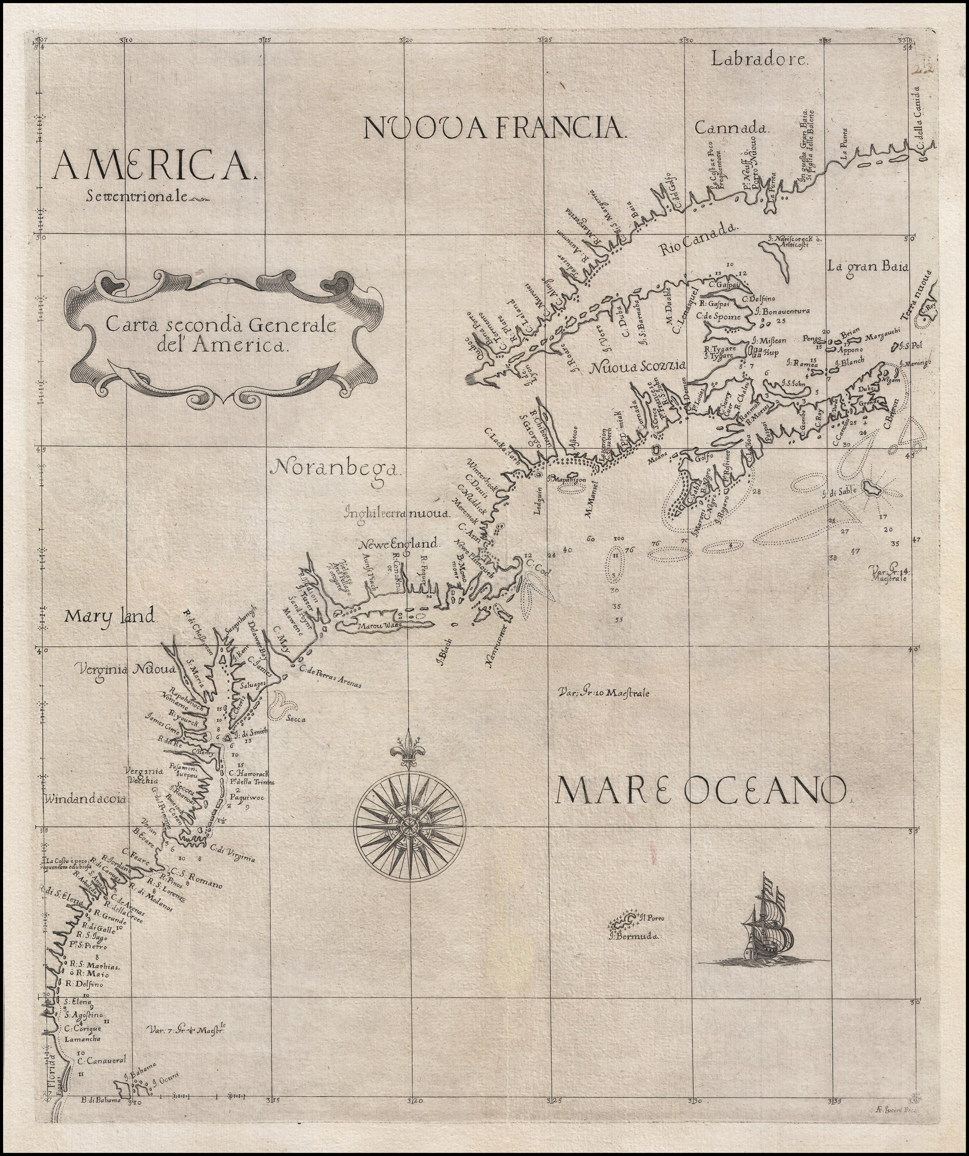 Extent: The Eastern Seaboard of North America, extending from Cape Canaveral (Florida), and the northern Bahamas to the Gulf of St. Lawrence, with the St. Lawrence upstream to Quebec. |
| 2. Dudley, Sir Robert Carta seconda / Generale / del’America. / XXII. / L.o 2.o [2b] AF: Lucini Fece. [5e, ob] Border: 434 x 355mm. From: Dudley ‘Dell’Arcano Del Mare’ 1661 | State 2: ‘XXII. / L[ibr].o 6.o [ie sesto]’ has been added in the title cartouche, and the plate number erased from outside the upper border. |
| 3. Dudley, Sir Robert Carta particolare della nuoua Belgia / è parte della nuoua Anglia. / La longitudine Cominca da l’Isola di Pico d’Asores. / D’America Carta. II. [2b] AF: Lucini Fece. [1e] Border: 471 x 382mm. From: Dudley Arcano Del Mare 1646-1648 | Extent: Cape Hinlopen to Maine. |
| 4. Dudley, Sir Robert Carta particolare della nuoua Belgia / è parte della nuoua Anglia. / La longitudine Cominca da l’Isola di Pico d’Asores. / D’America Carta. II. / L.o 6.o [2b] AF: Lucini Fece. [1e] Border: 471 x 382mm. From: Dudley Arcano Del Mare 1661 | 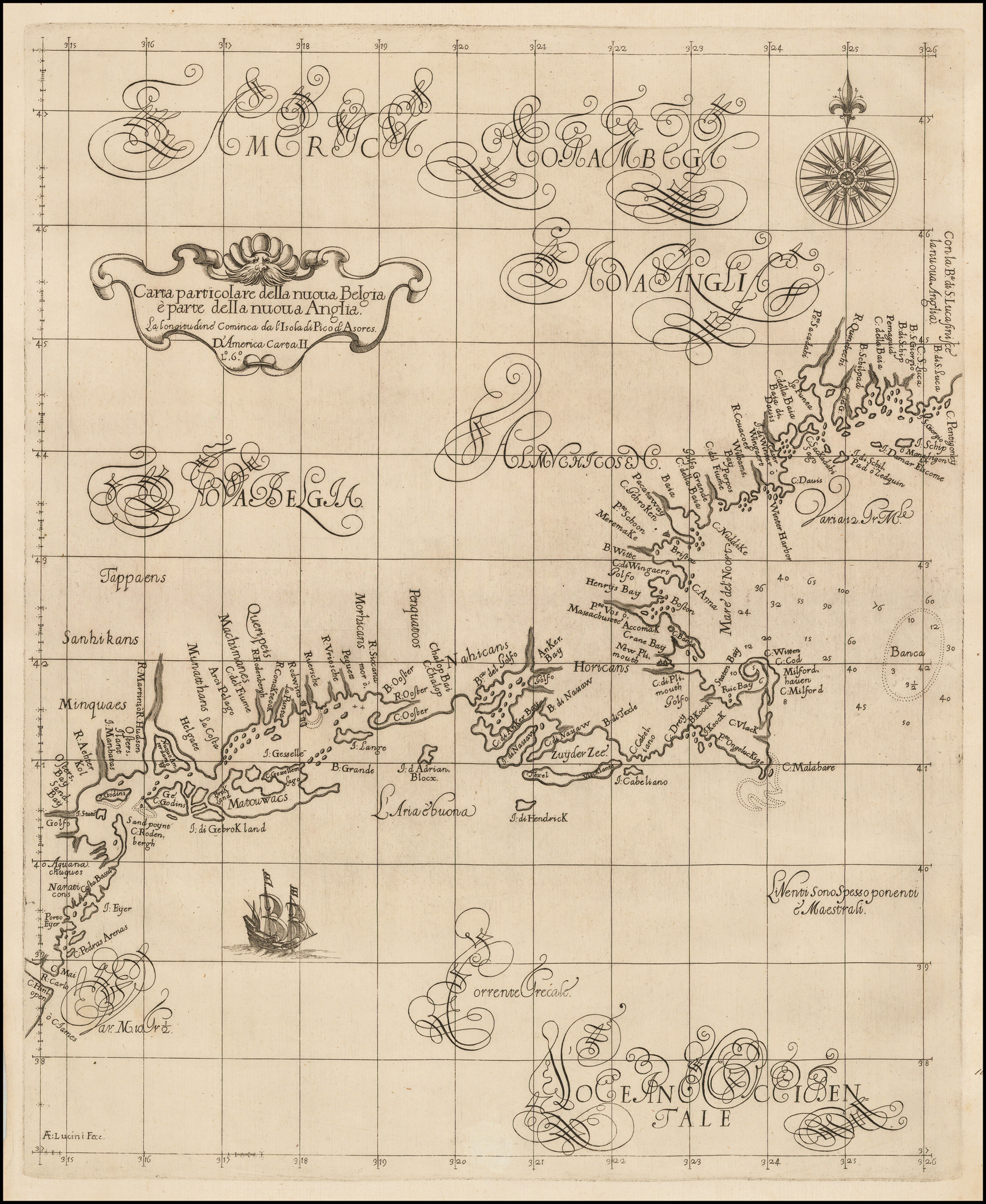 |
| 5. Lootsman, Jacob Theunisz Pascaerte van / NIEV NEDERLANT, / Virginies, Nieu Engelant en Nova / Francia, van C. of Faire tot C. Forchu. / [rule] / Amsterdam / By Theunis Iacobsz op’t / water inde Lootsman. [1b] 420 x 525mm. From: Lootsman Separate publication [ca. 1650 ?] |  Although first recorded by Koeman as appearing in 1666, this chart is presumed to date from rather earlier, as Theunis Jacosz died in 1650. Extent: Cape Lookout – Nova Scotia |
| 6. Lootsman, Jacob Theunisz Pascaerte van / NIEV NEDERLANT, / Virginies, Nieu Engelant en Nova / Francia, van C. of Faire tot C. Forchu. / [rule] / Amsterdam / By Theunis Iacobsz op’t / water inde Lootsman. [1b] 420 x 525mm. From: Lootsman’s ‘Nieuwe Water-Wereldt’ 1681 | State 2: with a new cartouche added around the scale bar. |
| 7. Colom, Arnold Pascaarte / van / NIEU NEDERLANDT / uytgegeven / door / ARNOLD COLOM. / t’Amsterdam / opt Water by de Nieuwe brugh inde Lichtende / Colom. / 1656. [2b] 13 [5e, ob] 545 x 632mm. From: Colom’s ‘Ora Maritima Orbis Universi’ [1656] | Extent: approximately Savannah – Cape St. Ann; |
| 8. Colom, Arnold Pascaarte / van / NIEU NEDERLANDT / uytgegeven / door / ARNOLD COLOM. / t’Amsterdam / opt Water by de Nieuwe brugh inde Lichtende / Colom. [2b] 13 [5e, ob] 545 x 632mm. From: Colom’s ‘Ora Maritima Orbis Universi’ [1658] | 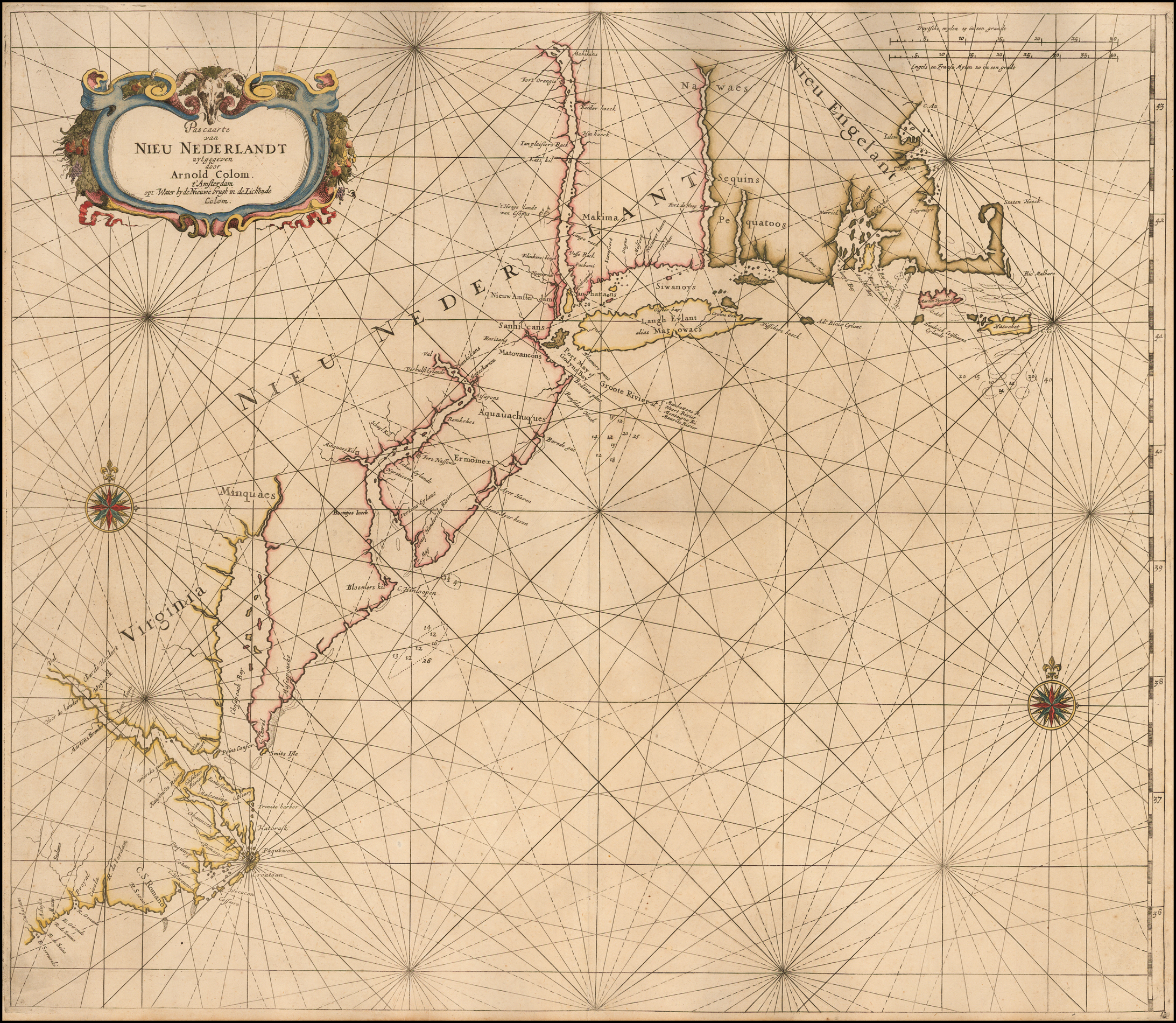 State 2: with the date erased from the title, but with the plate number unchanged. |
| 9. Colom, Arnold Pascaarte / van / NIEU NEDERLANDT / uytgegeven / door / ARNOLD COLOM. / t’Amsterdam / opt Water by de Nieuwe brugh inde Lichtende / Colom. [2b] 16 [5e, ob] 545 x 632mm. From: ‘Zee-Atlas, ofte Water-Wereldt’ [1659 ?] | State 3: with the plate number ’16’ inserted. |
| 10. Colom, Arnold Pascaarte / van / NIEU NEDERLANDT / uytgegeven / door / Hendrick Doncker. / ‘t Amsterdam / Inde Nieubrugsteegh in’t stuermans Gereetschap het derde huys vande / Nieubrugh inde straet. [2b] 16 [5e, ob] 545 x 635mm. From: Doncker Separate publication [ca. 1670] | State 4: with Hendrick Doncker’s imprint substituted in the title. |
| 11. Colom, Arnold Pascaarte / van / NIEU NEDERLANDT / uytgegeven / door / Hendrick Doncker. / ‘t Amsterdam / Inde Nieubrugsteegh in’t stuermans Gereetschap het derde huys vande / Nieubrugh inde straet. [1a] 16 [5e, ob] 521 x 610mm. From: Doncker Separate publication [ca. 1676 ?] | State 5: the plate has been cut down along the left hand and upper borders, with the consequent loss of 7 names in the Carolinas and Virginia, and one in New England. The two scale bars have been re-engraved below their original position, with only the heading for the English scale bar remaining from the first state. |
| 12. Alphen, Pieter van Nieuwe / Wassende Graade / PASKAERT. / van / Espanola tot Terraneuf. / [rule] / t’Rotterdam. / Door Pieter van Al= / phen Bij de Roo brug inde Vierige Colom. [1c] 436 x 550 Inset: 147 x 192mm. From: Alphen’s ‘Nieuwe Zee-Atlas, Of Water-Werelt’ 1660 | Extent: Florida & Cuba – Newfoundland. |
| 13. Alphen, Pieter van Nieuwe / Wassende Graade / PASKAERT. / van / Espanola tot Terraneuf. / [rule] / t’Rotterdam. / Door Pieter van Al= / phen Bij de Roo brug inde Vierige Colom. [1c] 7 [1e] 436 x 550 Inset: 147 x 192mm. From: Alphen’s ‘Nieuwe Zee-Atlas, Of Water-Werelt’ 1660 | State 2: with the plate number added. |
| 14. Alphen, Pieter van Nieuwe / Wassende Graade / PASKAERT. / van / Espanola tot Terraneuf. / [rule] / t’Rotterdam. / by Pieter van Al= / phen Bij de Roo brug inde Vierige Colom. [1c] 7 [1e] 436 x 550 Inset: 147 x 192mm. From: Alphen’s ‘Nieuwe Zee-Atlas, Of Water-Werelt’ 1682 | State 3: with the title re-engraved. |
| 15. Doncker, Hendrick Sr. PAS CAERT VAN / NIEU NEDERLAND, / Virginia en Nieu Engelant. / Nieulycx uytgegeven / T’AMSTERDAM By Hendrick Doncker / Boek verkooper en Graedbooghmaker, Inde Nieu= / brugsteegh In’t Stuurmans gereetschap. 1660. [2b] 447 x 548mm. From: Doncker’s ‘De Zee-Atlas Ofte Water-Waereld’ 1660 | 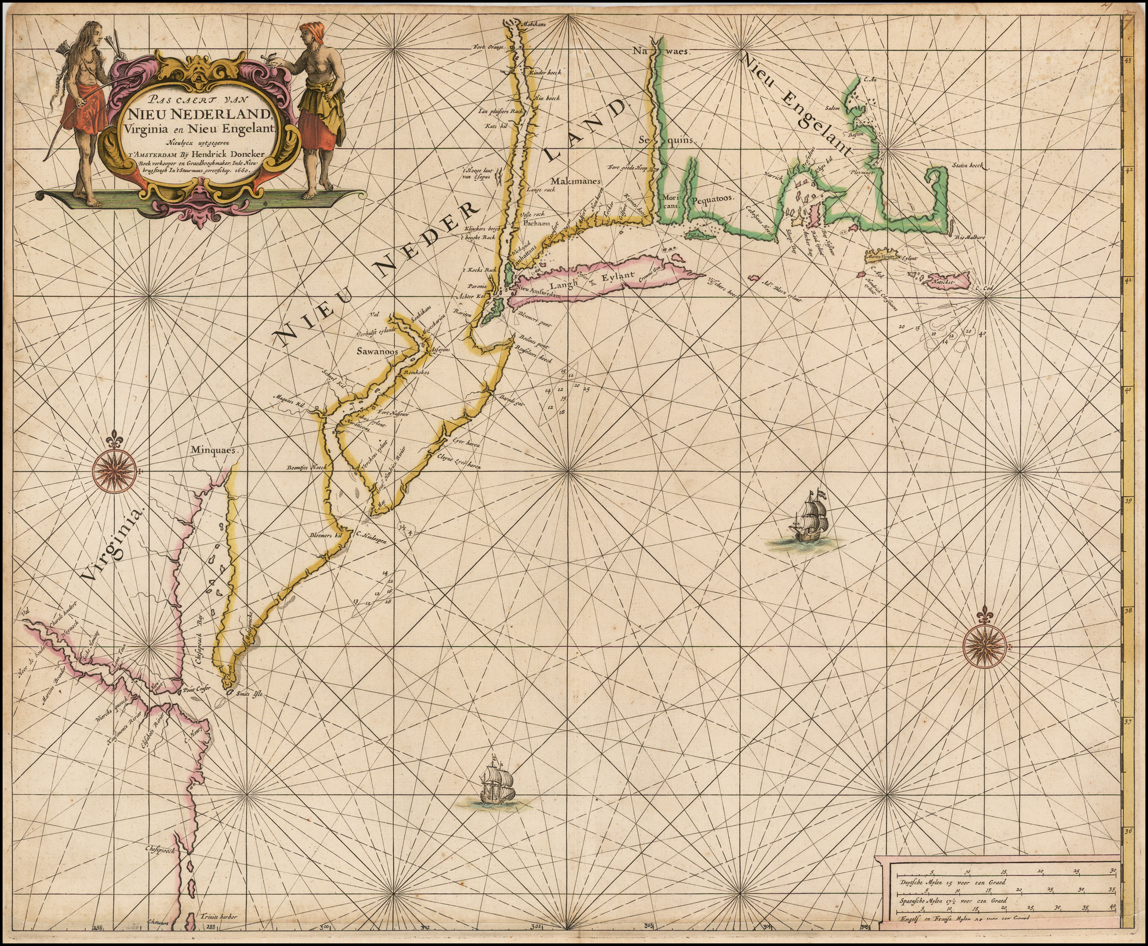 Extent: Trinity Harbour – Cape St. Ann. |
| 16. Doncker, Hendrick Sr. PAS CAERT VAN / NIEU NEDERLAND, / Virginia en Nieu Engelant. / Nieulycx uytgegeven / T’AMSTERDAM By Hendrick Doncker / Boek verkooper en Graedbooghmaker, Inde Nieu= / brugsteegh In’t Stuurmans gereetschap. [2b] 447 x 548mm. From: Doncker’s ‘De Zee-Atlas ofte Water-Waereld’ 1670 | State 2: with the date erased from the title. |
| 17. Doncker, Hendrick Sr. PAS CAERT VAN / NIEU NEDERLAND, / Virginia en Nieu Engelant. / Nieulycx uytgegeven / T’AMSTERDAM By Hendrick Doncker / Boek verkooper en Graedbooghmaker, Inde Nieu= / brugsteegh In’t Stuurmans gereetschap. [2b] A Chart of the Sea Coasts of NEW-ENGLAND, NEW-JARSEY, / Virginia, Maryland, And Carolina / From C. Cod to C. Hatteras. [2c] 447 x 548mm. From: Doncker’s ‘De Zee-Atlas ofte Water-Waereld’ [ca. 1680 ?] | State 3: The plate has been heavily re-worked, with the addition of the English title, and the coastlines completely revised. |
| 18. Loon, Johannes van Pas caerte van / NIEV-NEDERLAND / en de Engelsche / VIRGINIES; / Van Cabo Cod, tot Cabo Canrick. / ‘t Amsterdam, / By Iohannes van Loon, Plaetsnyder en Zee / caertmaecker. [1a] 33 [5e] 431 x 531mm. From: Loon’s ‘Klaer Lichtende Noort-Ster’ 1661 | 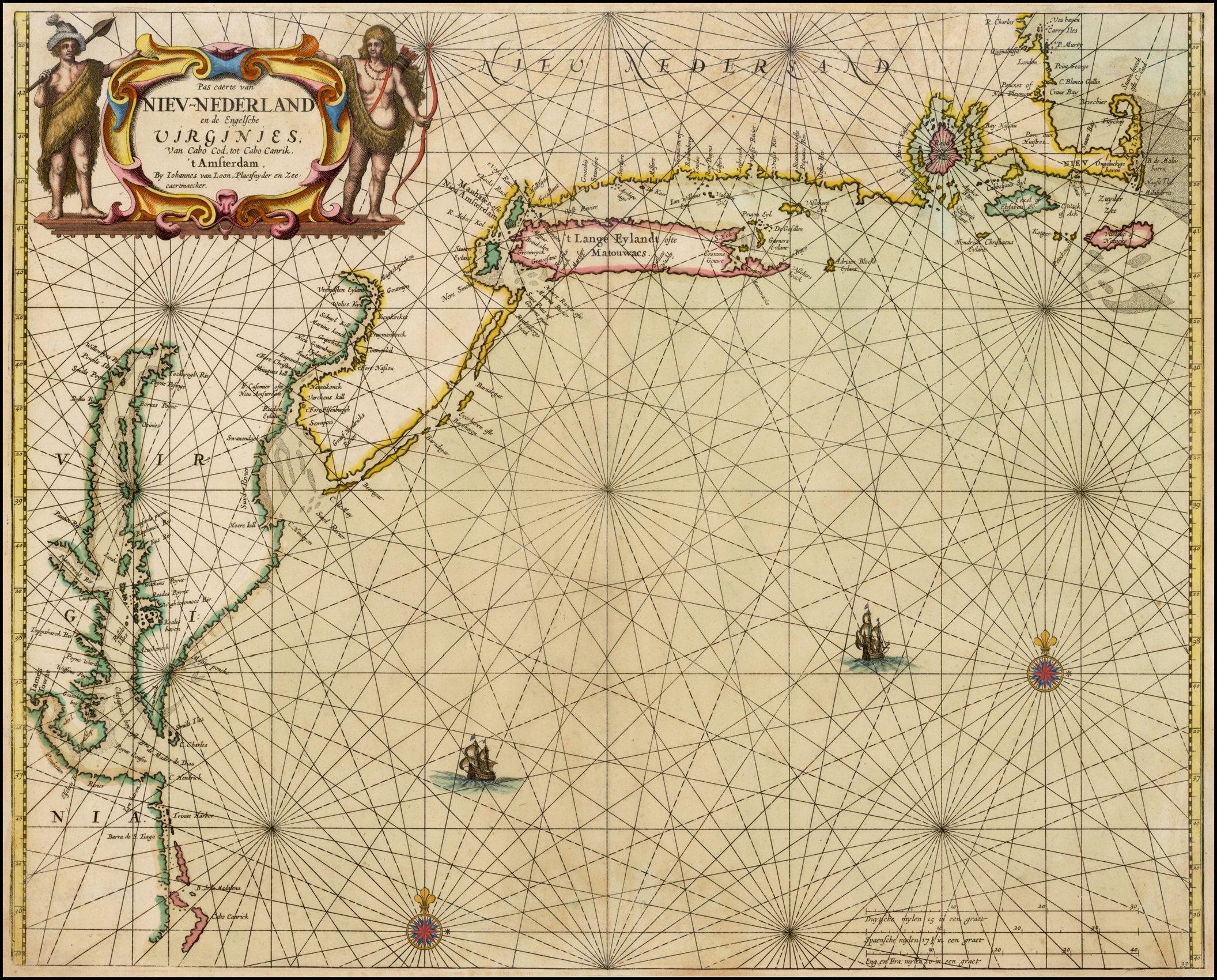 Extent: Cape Canrick – Boston Harbour. |
| 19. Loon, Johannes van Pas-caerte van / TERRA NOVA, / Nova Francia, Nieuw Engeland en de gro= / te Rivier van Canada. / ‘t Amsterdam, / By Iohannes en Gieles van Loon Plaetsnyder en Zee= / caert-maker. [1a] 34 [5e] 430 x 543mm. From: Loon’s ‘Klaer Lichtende Noort-Ster’ 1661 | Van Loon’s ‘Klaer Lichtende Noort-Ster Ofte Zee-Atlas’ |
| 20. Loon, Johannes van Pas-caerte van / TERRA NOVA, / Nova Francia, Nieuw Engeland en de gro= / te Rivier van Canada. / ‘t Amsterdam, / By Iohannes van Loon Plaet-snyder en Zee= / caert-maker. [1a] 34 [5e] 430 x 543mm. From: Loon’s ‘Klaer Lichtende Noort-Ster’ 1661 | 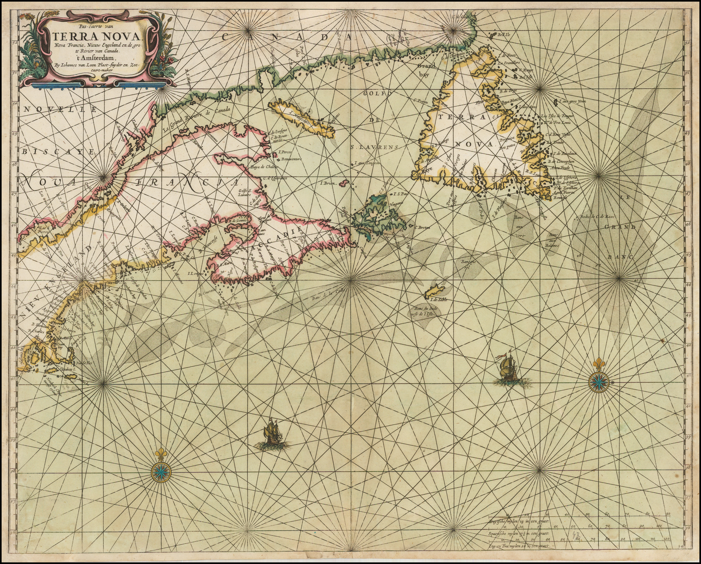 State 2: with Gilles van Loon’s imprint removed from the title. |
| 21. Loon, Johannes van Pas-caerte van / TERRA NOVA, / Nova Francia, Nieuw Engeland en de gro= / te Rivier van Canada. / ‘t Amsterdam, / By Iohannes van Loon Plaet-snyder Inventor / en Johann: Janssonius van Waesberge excud. [1a] 47 [5e] 430 x 543mm. From: Loon’s ‘Klaer Lichtende Noort-Ster’ 1668 | State 3: with Johannes Janssonius van Waesberge’s imprint added in the title cartouche. |
| 22. Dudley, Sir Robert Carta seconda Gener= / ale Del America. [1a] Il Cau:re AF Lucini Fecit. [5e, ob] 220 x 195mm. From: Dudley [Arcano Del Mare 1661 ?] | Reduced version of Dudley’s folio chart of the eastern seaboard, known in two, or possibly three examples. There is some debate about the origin and authenticity of the charts. |
| 23. Colom, Jacob Aertsz. Pas caerte van / TERRA NOVA / Nova Francia Nieuw Engelandt en de / Grote Rivier van Canada. / ‘t AMSTERDAM / By Iacob Colom. [1a] 379 x 538mm. From: Colom’s ‘Atlas ofte Werelts-Water-Deel’ 1663 | |
| 24. Colom, Jacob Aertsz. [Untitled Chart Of ‘Virginia’ ‘NIEU NEDERLANT’ and ‘Nieu Engelant] T’AMSTERDAM / By Iacob Colom. [2b] 375 x 530mm. From: Colom’s ‘Atlas ofte Werelts-Water-Deel’ 1663 | Extent: Cape Henry – Cape Ann. State 1 lacks the inset. |
| 25. Colom, Jacob Aertsz. [Untitled Chart Of ‘Virginia’ ‘NIEU NEDERLANT’ and ‘Nieu Engelant] T’AMSTERDAM / By Iacob Colom. [2b] 375 x 530mm. From: Colom’s ‘Atlas ofte Werelts-Water-Deel’ 1663 | State 2: with the addition of the inset of the Carolinas. |
| 26. Goos, Pieter Pas caerte van / NIEU NEDERLANDT / en de Engelsche / VIRGINIES / Van Cabo Cod tot Cabo Canrick. [1a] 425 x 525mm. From: Goos’ ‘De Zee-Atlas, Ofte Water-Weereld’ 1666 | 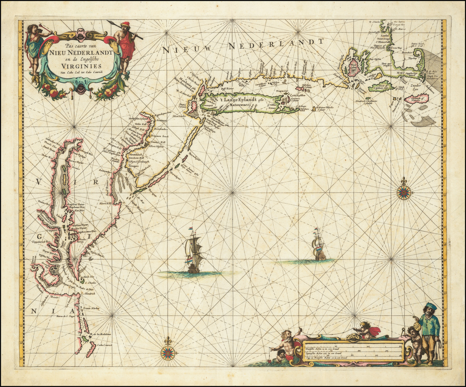 Extends from Cape Canrick to Boston. |
| 27. Doncker, Hendrick Pas-Caert van / TERRA NOVA, / Nova Francia, Nieuw-Engeland / en de groote Rivier van Canada. / ‘t Amsterdam, / By Hendrick Doncker, Boekverkoper en Graed= / boogh maker inde Nieuwbrug steegh. [1a] 431 x 517mm. From: Doncker’s ‘La Atlas … Mundo Aguado’ 1669 | 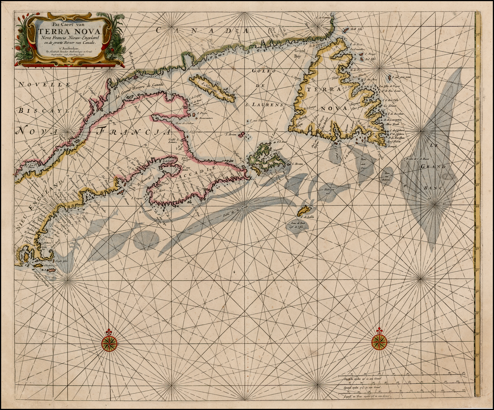 Extent: Rhode Island – Newfoundland. |
| 28. Doncker, Hendrick Pas-Caert van / TERRA NOVA, / Nova Francia, Nieuw-Engeland / en de groote Rivier van Canada. / ‘t Amsterdam, / By Hendrick Doncker, Boekverkoper en Graed= / boogh maker inde Nieuwbrug steegh. [1a] 431 x 517mm. From: Doncker’s ‘Groote Vermeerderde Zee-Atlas’ 1678 | State 2: the Grand Banks off Newfoundland have been re-engraved. In the first state, the bank was arched with the top of the bank extending to the north-east. In the second state, the right hand border of the bank is in a bow shape, with the top extending north-westwards, and with many additional soundings added within the banks. |
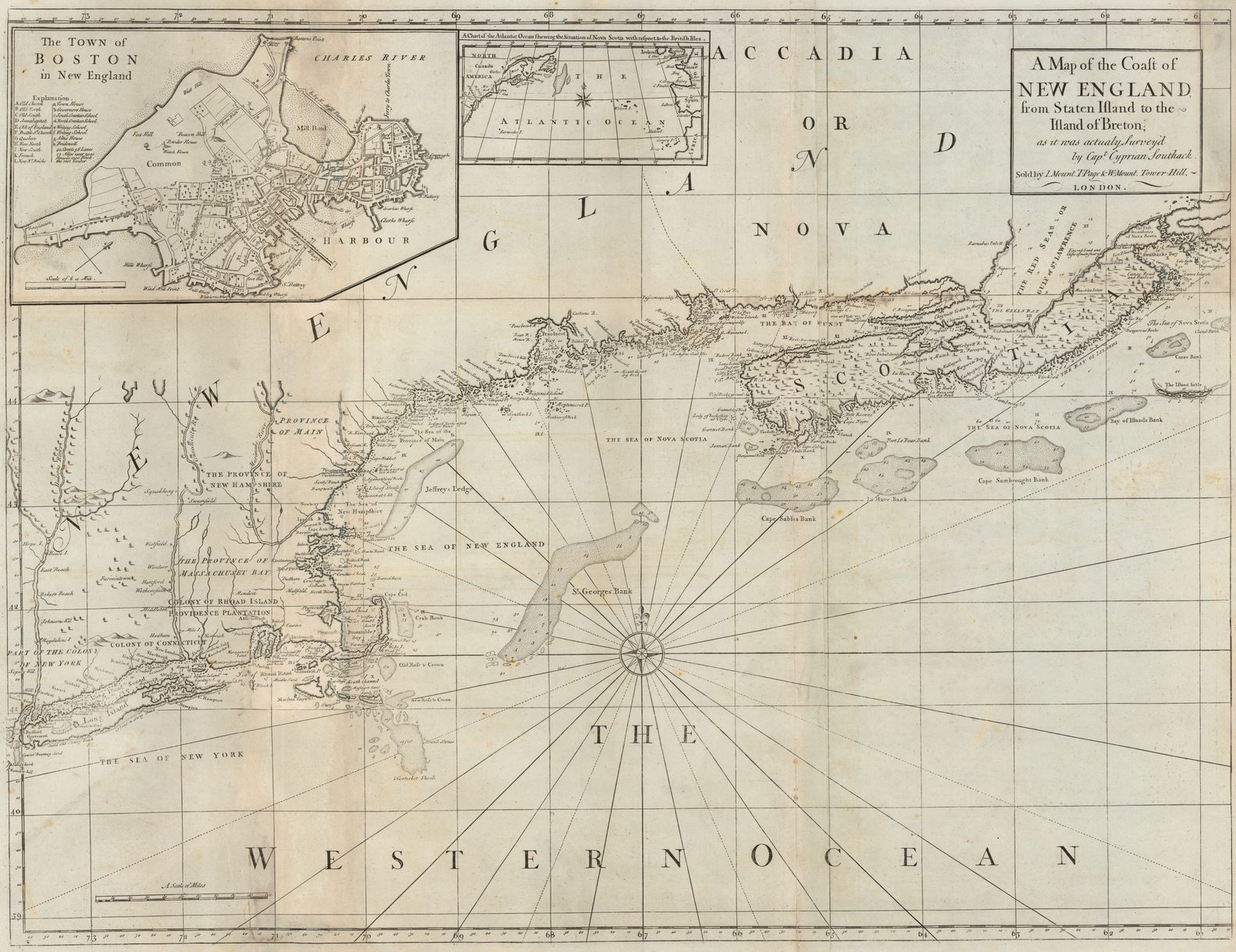
| 29. Roggeveen, Arent Pascaerte van / NIEU NEDERLAND / Streckende vande Zuÿdt Revier / tot de Noordt Revier / en ‘t Lange Eyland. [2d] 27 [5d] 417 x 504mm. From: Roggeveen’s ‘… Brandende Veen’ 1675 | 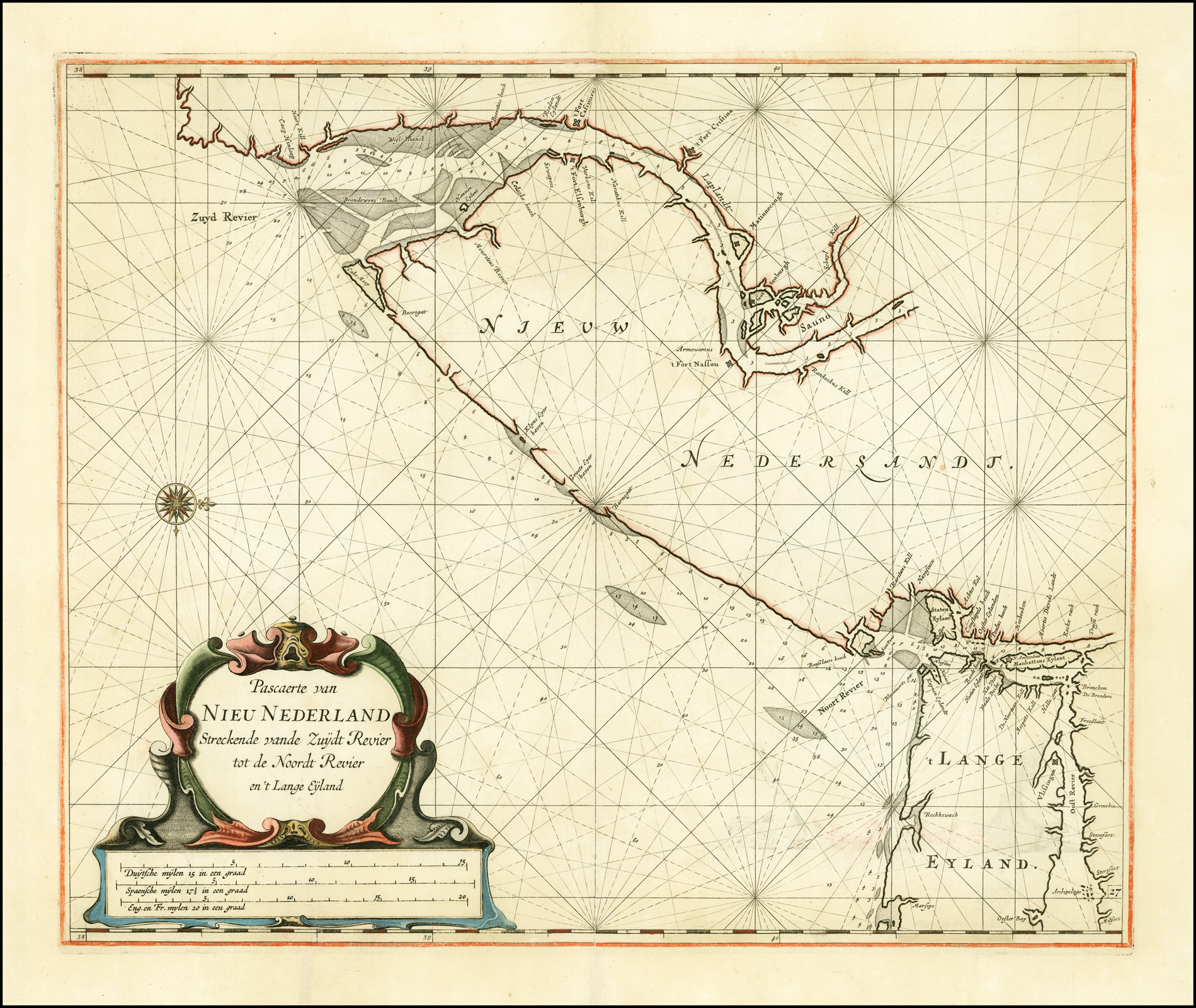 Extent: Delaware Bay to Milford, Connecticut, including Manhattan and Long Island. |
| 30. Roggeveen, Arent Pascaerte van / NIEU NEDERLAND / Streckende vande Zuydt Revier / tot de Noordt Revier / en ‘t Lange Eyland. / Jac. Robyn exc. [2d] 27 [5d] 417 x 504mm. From: Roggeveen’s ‘… Brandende Veen’ [1689] | State 2: with Robijn’s imprint added in the title. |
| 31. Roggeveen, Arent Pascaerte van / NIEU NEDERLAND / Streckende vande Zuydt Revier / tot de Noordt Revier / en ‘t Lange Eyland. / … [2d] 27 [5d] 417 x 504mm. From: Loots ‘New Great Sea-Mirrour’ 1717 | A hypothetical third state, with the imprint of Johannes Loots, in Loots’ ‘The Fifth Part Of The New Great Sea-Mirrour’ (1717) ? The only extant copy of the atlas, in the LC, lacks the map, but it is possible that the map was re-engraved in the same way as its companions, below. |
| 32. Roggeveen, Arent Pascaerte van / NIEU NEDERLAND / Streckende vande Noordt Rivier / tot Hendrick Christiaens Eylandt. [4e] 28 [5d] 409 x 513mm. From: Roggeveen’s ‘… Brandende Veen’ 1675 | Extent: New York Harbour – Rhode Island. |
| 33. Roggeveen, Arent Pascaerte van / NIEU NEDERLAND / Streckende vande Noordt Rivier / tot Hendrick Christiaens Eylandt. / Jac. Robyn exc. [4e] 28 [5d] 409 x 513mm. From: Roggeveen’s ‘Brandende Veen’ [1689] | 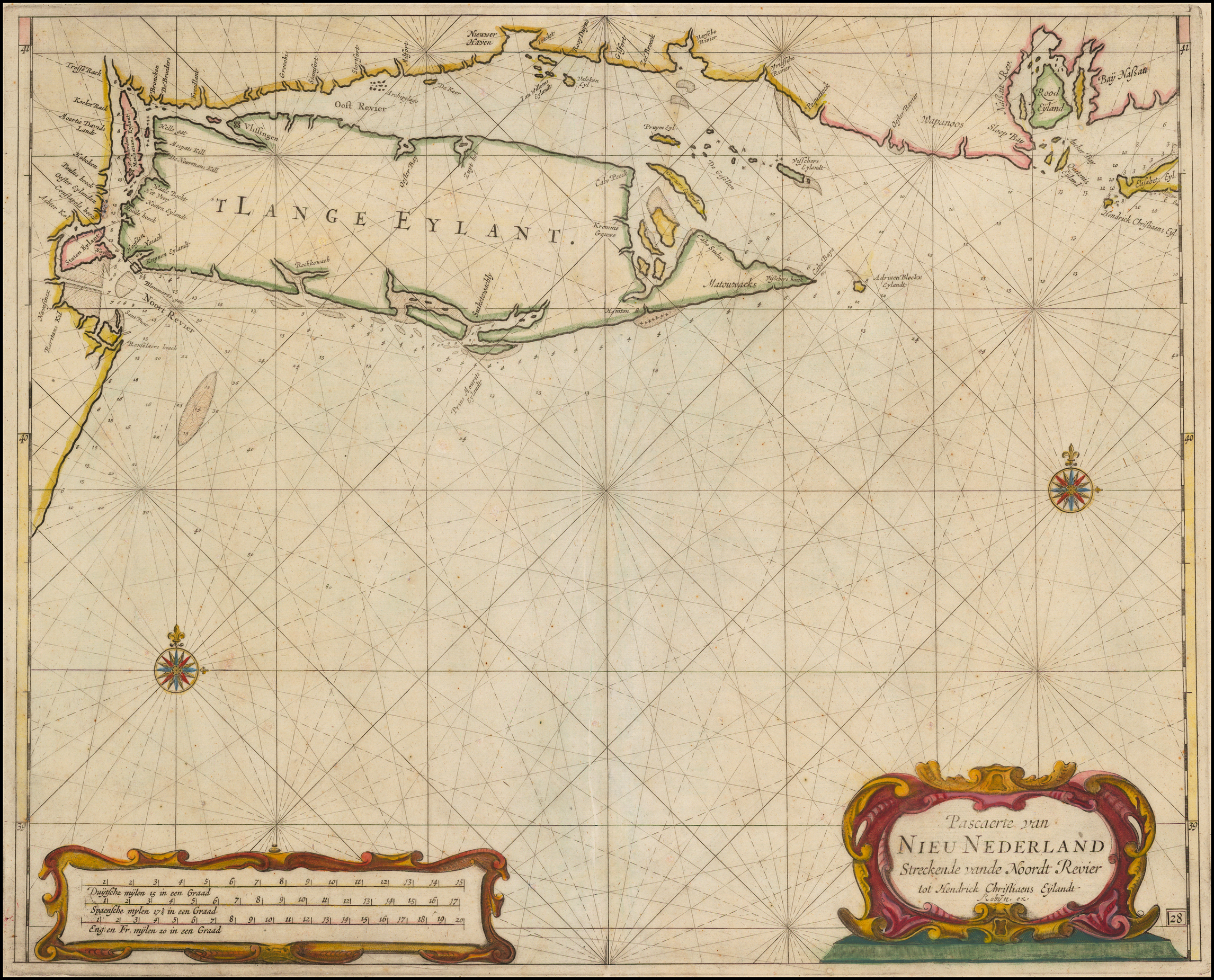 State 2: with the insertion of Robijn’s imprint, and the plate number. |
| 34. Roggeveen, Arent Pascaerte van / NIEU NEDERLAND / Streckende vande Noordt Rivier / tot Hendrick Christiaens Eylandt. / Jac. Robyn exc. [4e] 409 x 513mm. From: Roggeveen ‘Het Brandende Veen’ [1698] | State 3: with the plate number deleted. |
| 35. Roggeveen, Arent Pascaerte van / NIEU NEDERLAND / Streckende vande Noordt Rivier / tot Hendrick Christiaens Eylandt. / by I. Loots. [4e] 409 x 513mm. From: Loots ‘New Great Sea-Mirrour’ 1717 | State 4: with Loots’s imprint inserted. |
| 36. Roggeveen, Arent Pascaert van / NIEU NEDERLAND / Van Hendrick Christiaens Eÿland / tot Staten hoeck of Cabo Cod. [5a] 29 [5e] 410 x 508mm. From: Roggeveen’s ‘… Brandende Veen’ 1675 | Extent: Rhode Island – New Plymouth. |
| 37. Roggeveen, Arent Pascaert van / NIEU NEDERLAND / Van Hendrick Christiaens Eÿland / tot Staten hoeck of Cabo Cod. / Jac. Robyn exc. [5a] 29 [5e] 410 x 508mm. From: Roggeveen’s ‘… Brandende Veen’ [1689] | 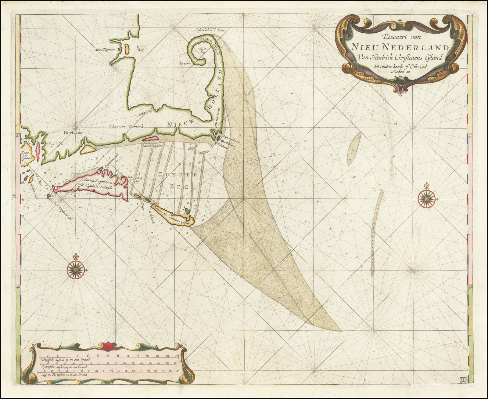 State 2: with Robijn’s name inserted in the title. |
| 38. Roggeveen, Arent Pascaert van / NIEU NEDERLAND / Van Hendrick Christiaens Eÿland / tot Staten hoeck of Cabo Cod. / by I. Loots. [5a] 410 x 508mm. From: Loots ‘New Great Sea-Mirrour’ 1717 | State 3: with the substitution of Loots’ imprint. |
| 39. Roggeveen, Arent Pascaerte van / TERRA NOVA NOVA FRANCIA NIEVW ENGELAND / En de Groote Revier van CANADA. [2a] 439 x 541mm. From: Roggeveen’s ‘… Brandende Veen’ 1675 | Extent: Rhode Island – Newfoundland. |
| 40. Roggeveen, Arent Pascaerte van / TERRA NOVA NOVA FRANCIA NIEVW ENGELAND / En de Groote Revier van CANADA. [2a] 439 x 541mm. From: Roggeveen’s ‘… Turba Ardiente’ 1680 | State 2: The Grand Banks have been heavily re-engraved, with their shape altered. and many soundings added. |
| 41. Roggeveen, Arent Pascaerte van / TERRA NOVA NOVA FRANCIA NIEVW ENGELAND / En de Groote Revier van CANADA. / Jac. Robyn exc [2a] 33 [5d] 439 x 541mm. From: Roggeveen’s ‘… Brandende Veen’ [1689] | State 3: with the addition of Robyn’s imprint, and the plate number. |
| 42. Roggeveen, Arent Pascaerte van / TERRA NOVA NOVA FRANCIA NIEVW ENGELAND / En de Groote Revier van CANADA. / Jac. Robyn exc [2a] 33 [5d] 439 x 541mm. From: Roggeveen’s ‘… Brandende Veen’ [1680] | Hypothetical fourth state with the imprint of Loots ? The example of the map noted in Loots’ ‘The Fifth Part Of The New Great Sea-Mirrour’, 1717, is unchanged from the previous state, but there may exist copies re-engraved in the same way as its companions. |
| 43. Seller, John Sr. A Chart / of the Sea coasts of / NEW=ENGLAND / NEW=JARSEY VIRGINIA / MARYLAND and CAROLINA / From C. Cod to C. Hatteras / By John Seller Hydrog.r / to the King. [2b] Iames Clerk sculpsit. [5e] 431 x 540mm. From: Seller ‘Atlas Maritimus’ 1675 |  |
| 44. Seller, John Sr. A Chart / of the Sea coasts of / NEW=ENGLAND / NEW=JARSEY VIRGINIA / MARYLAND and CAROLINA / From C. Cod to C. Hatteras / By J. Seller, J. Colson, W. Fisher, J. Atkinson, J. Thornton. [2b] Iames Clerk sculpsit. [5e] 431 x 540mm. From: Seller ‘Atlas Maritimus’ 1675 [1677] | State 2: with the substitution of the imprint of Seller and his partners. |
| 45. Seller, John Sr. A Chart of the / Coast of / AMERICA / from New found Land to Cape / Cod by Iohn Seller Hyrographer / to the King. [5e] 437 x 530mm. From: Seller Atlas Maritimus 1675 | 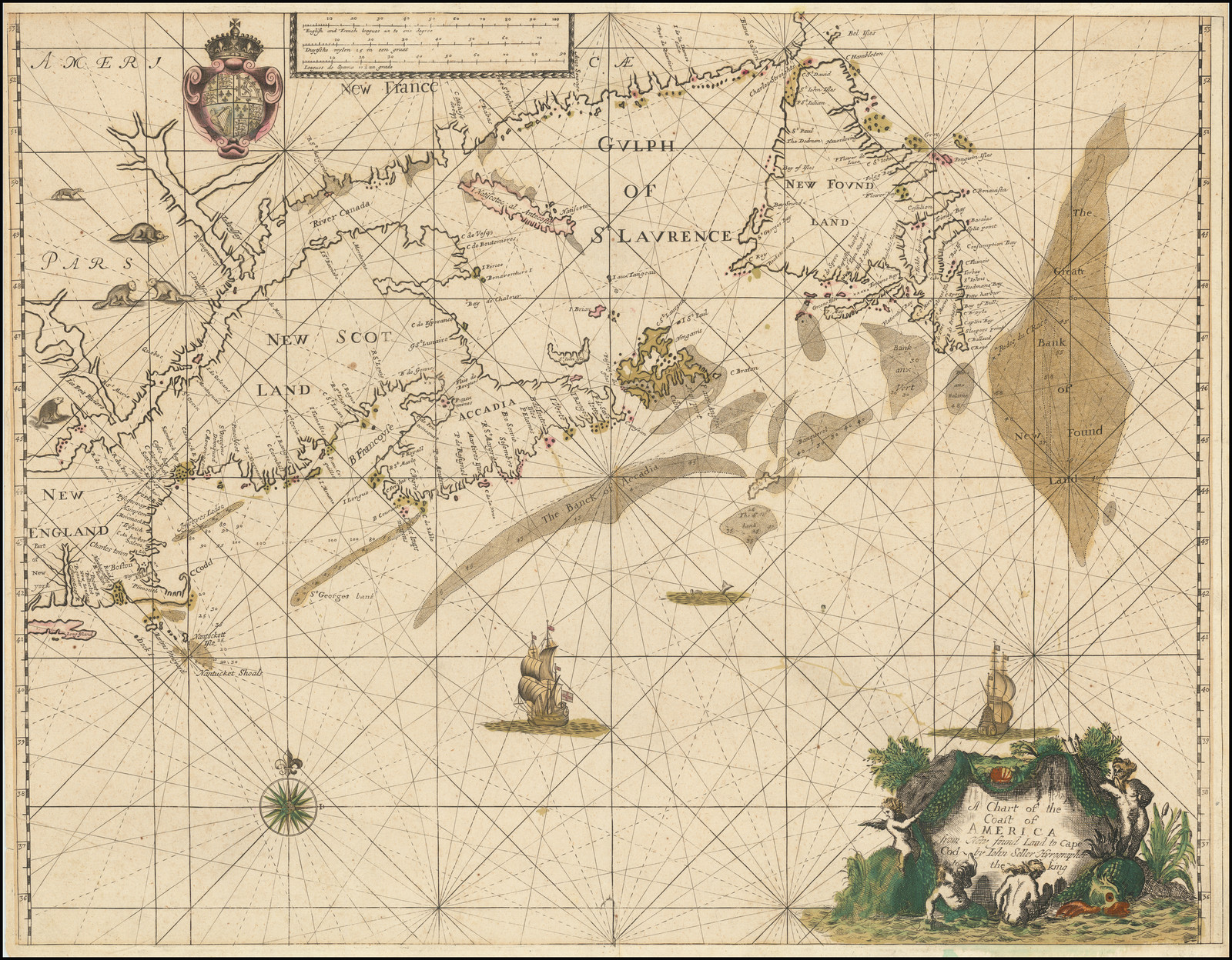 Extent: Eastern Long Island to Newfoundland, with the St. Lawrence upriver to ‘Le Trois Rivieres’. |
| 46. Seller, John Sr. A Chart of the / Coast of / AMERICA / from New found Land to Cape / Cod by Iohn Seller John Colson William Fisher / James Atkinson, and / John Thornton. [5e] 437 x 530mm. From: Seller Atlas Maritimus 1675 [1677] | 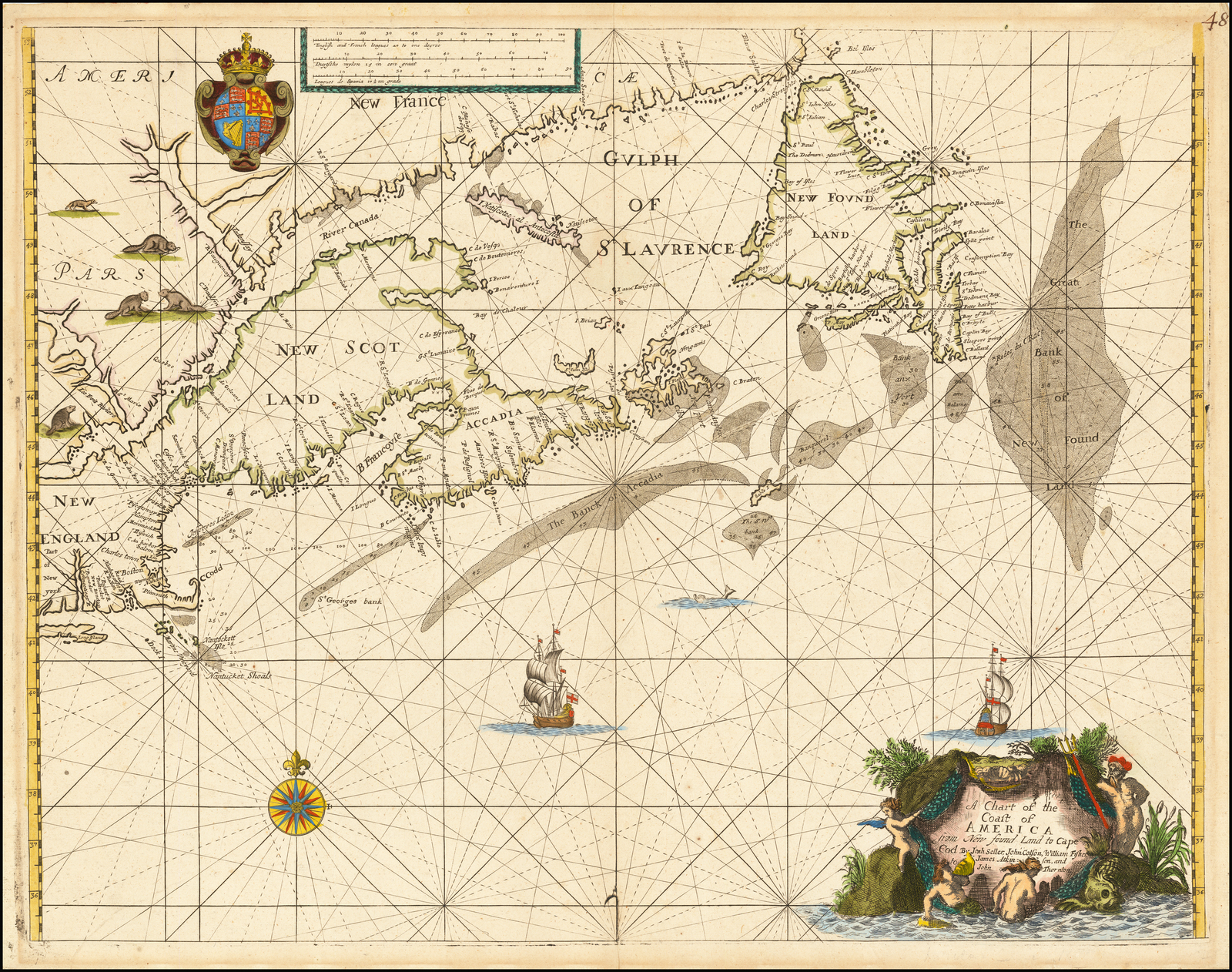 State 2: with the substitution of the imprint of Seller and his partners. |
| 47. Seller, John Sr. A New Chart for the / Sea coasts of / NEWFOUND LAND NEW SCOTLAND / NEW ENGLAND NEW JARSEY w.th / VIRGINIA and MARYLAND. / By John Thornton John Seller / William Fisher James Atkin= / son John Colson. [2b] 434 x 545mm. From: Seller Atlas Maritimus [1677] | Extent: ‘NOVA FRANCIA’ ‘Cambalu’ & ‘TERRA / NOVA’ to ‘C. Henry’, in ‘VIR / GI / NIA’. |
| 48. Seller, John Sr. A New Chart for the / Sea coasts of / NEWFOUND LAND NEW SCOTLAND / NEW ENGLAND NEW JARSEY w.th / VIRGINIA and MARYLAND. / [double rule] / By William Fisher & Rich.d Mount / at y.e Postern on Tower hill. [2b] 437 x 547mm. From: Fisher & Mount ‘Atlas Maritimus’ [ca. 1685] | State 2: with the substitution of the imprint of William Fisher and Richard Mount. |
| 49. Keulen, Johannes van Pas-Kaart / Vande Zee Kusten van / NIEW NEDERLAND / Anders Genaamt / NIEW YORK / Tusschen / Renselaars Hoek en de Staaten Hoek / Door CIVooght Geometra / T’ AMSTERDAM By / JOHANNIS VAN KEULEN / Boek en Zee Kaert verkoper aande Niewe brugh / Inde Gekroonde Lootsman / Met Privilegie voor 15 Iaaren. [1b] 518 x 580 Inset a: 155 x 580 b: 55 x 235mm. From: Van Keulen’s ‘Zee-Fakkel’ [1684] | Extent: New York Harbour – Cape Cod region. |
| 50. Keulen, Johannes van Pas-Kaart / Vande Zee Kusten van / NIEW NEDERLAND / Anders Genaamt / NIEW YORK / Tusschen / Renselaars Hoek en de Staaten Hoek / Door CIVooght Geometra / T’ AMSTERDAM By / JOHANNIS VAN KEULEN / Boek en Zee Kaert verkoper aande Niewe brugh / Inde Gekroonde Lootsman / Met Privilegie voor 15 Iaaren. [1b] 20 [1e] 518 x 580 Inset a: 155 x 580 b: 55 x 235mm. From: Van Keulen’s ‘Zee-Fakkel’ 1687 | 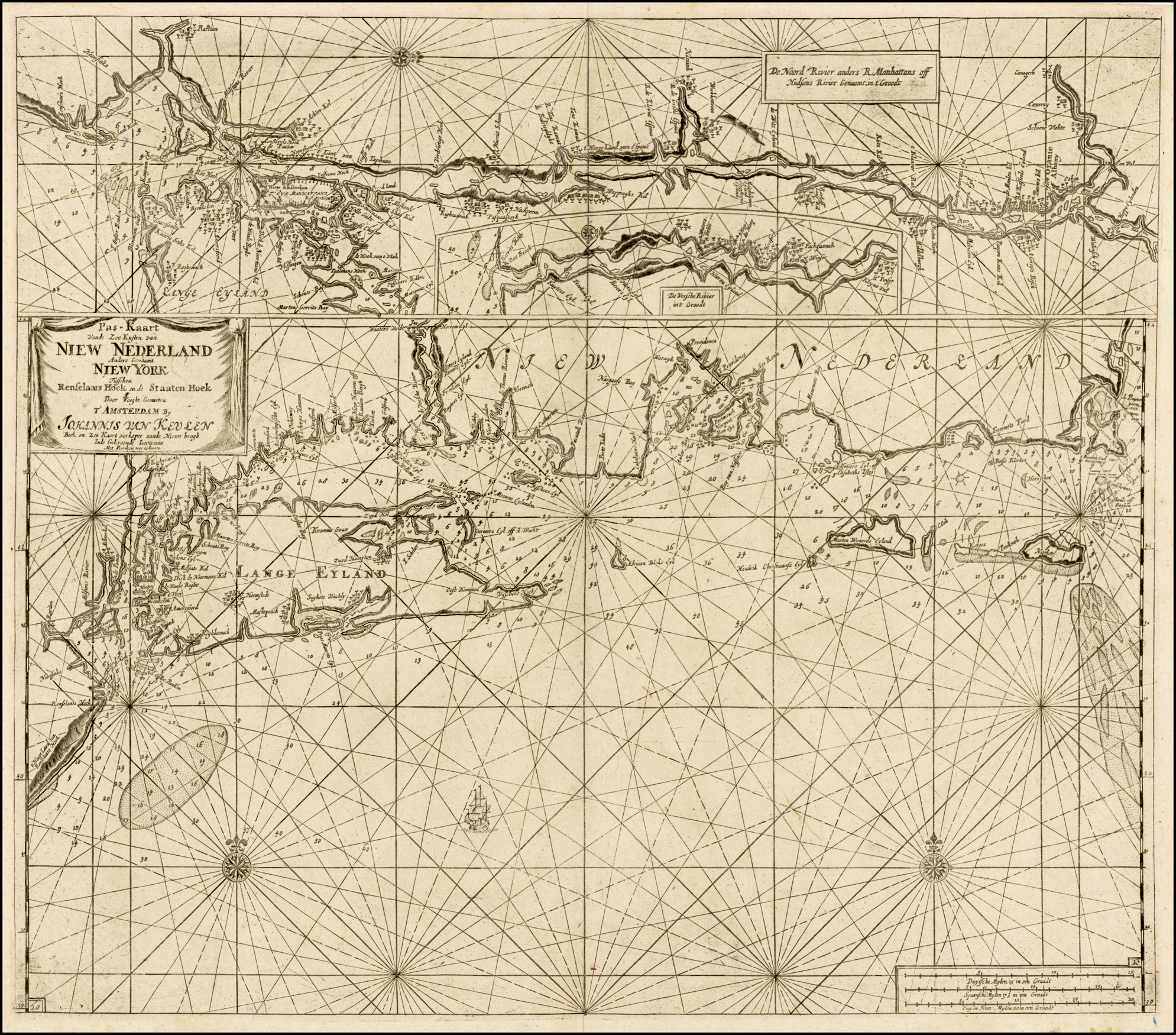 State 2: with the plate number ’20’ added, bottom left. |
| 51. Keulen, Johannes van Pas-Kaart / Vande Zee Kusten van / NIEW NEDERLAND / Anders Genaamt / NIEW YORK / Tusschen / Renselaars Hoek en de Staaten Hoek / Door CIVooght Geometra / T’ AMSTERDAM By / JOHANNIS VAN KEULEN / Boek en Zee Kaert verkoper aande Niewe brugh / Inde Gekroonde Lootsman / Met Privilegie voor 15 Iaaren. [1b] 20 [1e] 20 [5d] 518 x 580 Inset a: 155 x 580 b: 55 x 235mm. From: Van Keulen’s ‘Zee-Fakkel’ 1702 | 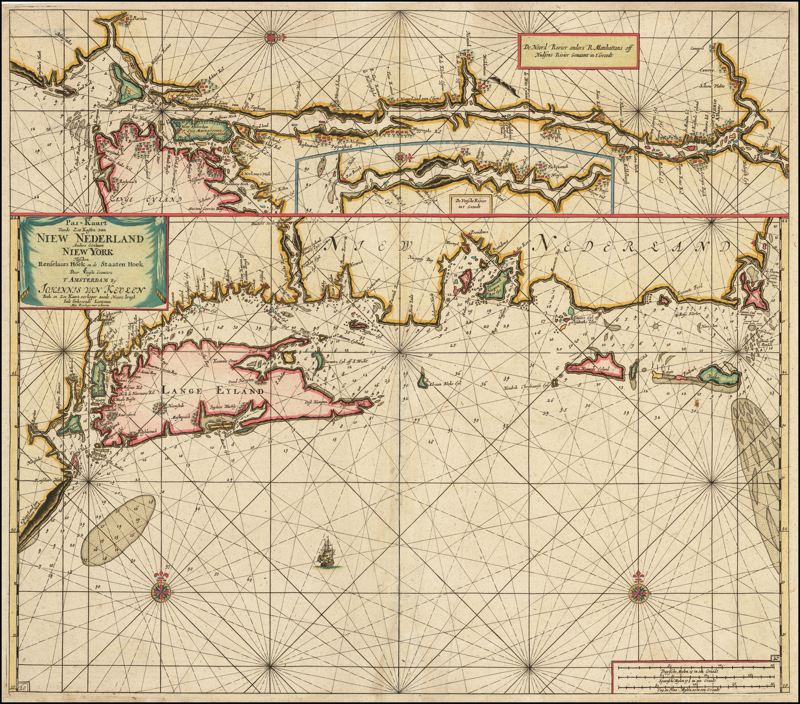 State 3: a frame surround has been added round the scale bar, and a second plate number ’20’ added above. Within the sea a ship has been added [2d] |
| 52. Keulen, Johannes van Pas-Kaart / Vande Zee Kusten inde Bocht van / NIEW ENGELAND / Tusschen de / Staaten Hoek en C. de Sable. / Door CIVooght Geometra / T’AMSTERDAM by / JOHANNES VAN KEULEN / Boek en Zee Kaart verkoper aande Niewe Brug / nde Gekroonde Lootsman. / met Privilegie voor 15 Iaaren. [1a] 515 x 580mm. From: Van Keulen’s ‘Zee-Fakkel’ [1684] | Extent: Nantucket Island – western Nova Scotia. |
| 53. Keulen, Johannes van Pas-Kaart / Vande Zee Kusten inde Bocht van / NIEW ENGELAND / Tusschen de / Staaten Hoek en C. de Sable. / Door CIVooght Geometra / T’AMSTERDAM by / JOHANNES VAN KEULEN / Boek en Zee Kaart verkoper aande Niewe Brug / nde Gekroonde Lootsman. / met Privilegie voor 15 Iaaren. [1a] 21 [1e] 515 x 580mm. From: Van Keulen’s ‘Zee-Fakkel’ 1687 | State 2: with the plate number ’21’ added, bottom left. |
| 54. Keulen, Johannes van Pas-Kaart / Vande Zee Kusten inde Bocht van / NIEW ENGELAND / Tusschen de / Staaten Hoek en C. de Sable. / Door CIVooght Geometra / T’AMSTERDAM by / JOHANNES VAN KEULEN / Boek en Zee Kaart verkoper aande Niewe Brug / nde Gekroonde Lootsman. / met Privilegie voor 15 Iaaren. [1a] 21 [1e] 21 [5e] 515 x 580mm. From: Van Keulen’s ‘Zee-Fakkel’ 1702 | 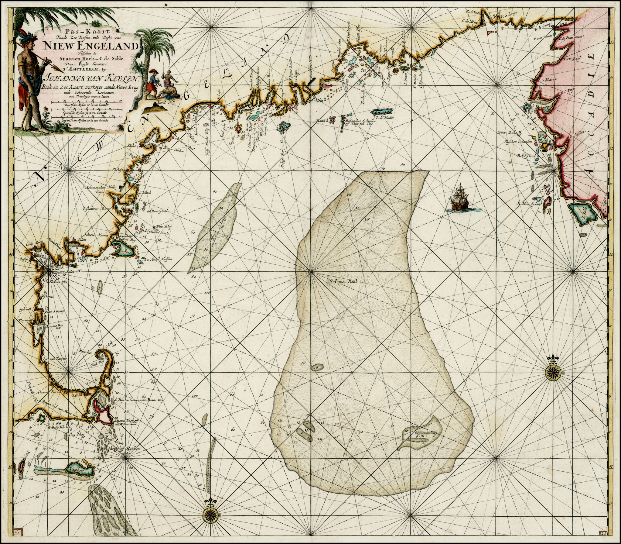 State 3: with the plate number added in the lower right corner. Additional shoals and soundings have been added, for example running south-westwards from ‘C. de Sable’ to the largest of the three shoals on St. George’s Bank, with the soundings on the southern side also inserted. Two shoals, with soundings, have been added to the north of the south-western compass rose [2d] |
| 55. Seller, John Sr. A Chart of the / Coast of / AMERICA / From Newfound Land / to Cape Cod / By J. Seller. [5e] 118 x 142mm. From: Seller Atlas Maritimus [Pocket Edition] 1682 | |
| 56. Seller, John Sr. A Chart / of the Sea Coasts of / New England / New Iarsey Virginia / Maryland & Carolina / From C. Cod to C. Hattaras / By Iohn Seller. [5e] 117 x 143mm. From: Seller Atlas Maritimus [Pocket Edition] 1682 | |
| 57. Doncker, Hendrick Sr. Pas caert van NIEU NEDERLAND, VIRGINIA, NIEU ENGELAND Als mede Penn-Silvania, met de Stad Philadelfia van Baston tot C: Carrick By Hendrick Doncker inde Nieuwen brugsteeg.’ A Chart of the Sea Coasts of / NEW NEDER LAND, VIRGINIA, / New-England, and Penn-Silvania. / With / the Citty of Philadelphia, from / Baston to Cabo Karrick. [1b] 511 x 585 Inset: 155 x 255 PM: – x 591mm. From: Doncker Separate publication | Extent: Cape Canrick – Boston The map was advertised in the ‘Amsterdamsche Courant’, on March 31st 1685: “tot Amsterdam by Henderick Doncker Boeckverkoper in de Nieuwe-brug Steech. … Item eene Paskaerte van nieuw Nederlandt en Penselvania met de stadt Philadelphia daer in gelegen”, although no example has been identified as being originally sold as a loose sheet. |
| 58. Doncker, Hendrick Sr. A Chart of the Sea Coasts of / NEW NEDER LAND, VIRGINIA, / New-England, and Penn-Silvania. / With / the Citty of Philadelphia, from / Baston to Cabo Karrick. [1b] TOT AMSTERDAM By GERARD VAN KEULEN / Aan de Nieuwen Brug Met Privilegie. [4a] 511 x 585 Inset: 155 x 255 PM: – x 591mm. From: Van Keulen’s Zee-Fakkel [1720] | 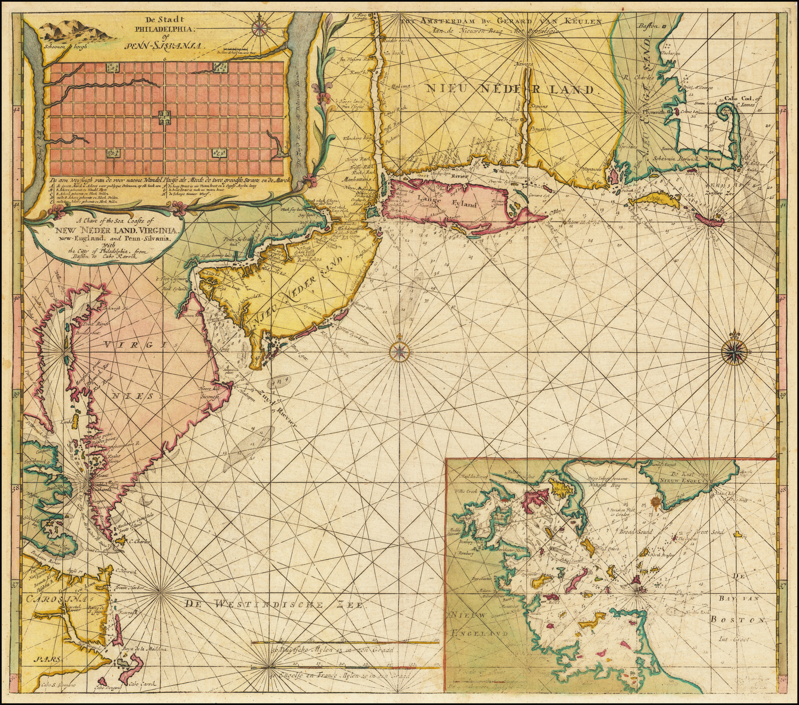 State 2: The original Dutch title has been replaced by an inset of Boston Harbour. Two scale bars have been added in the sea, and a number of new names have been inserted along the coastline in the map. ‘DE WESTINDISCHE ZEE’ is named. |
| 59. Thornton, John A New Chart of the Sea Coast of / Newfound land, new Scotland, / new England, new Jersey, Virginia, / Maryland, Pennsilvania, and / part of Carolina. / [double rule] / By Iohn Thornton Hydrographer at / the Signe of England, Scotland and / Ireland, in the Minories / London. [2b] 439 x 529mm. From: ‘The English Pilot. The Fourth Book’ 1689 | 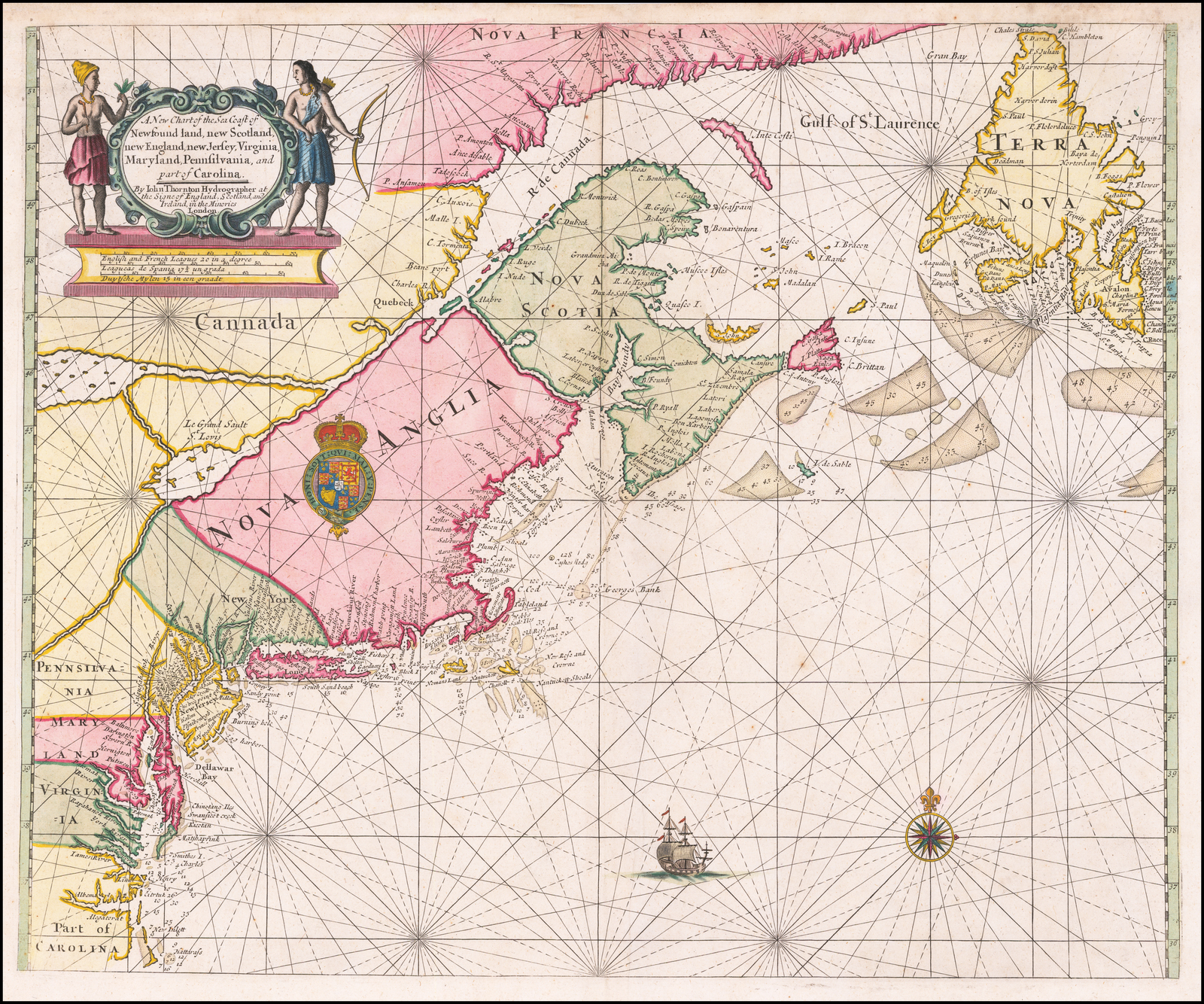 The map extends from ‘TERRA / NOVA’ & ‘NOVA FRANCIA’ to ‘Part of / CAROLINA’ & ‘Hattarass’ |
| 60. Thornton, John A New Chart of the Sea Coast of / Newfound land, new Scotland, / new England, new Jersey, Virginia, / Maryland, Pennsilvania, and / part of Carolina. / [double rule] / By Sam.l Thornton Hydrographer at / the Signe of England, Scotland and / Ireland, in the Minories / London. [2b] 438 x 533mm. From: Mount & Page [Untitled Sea-Atlas] [ca. 1716] | State 2: with the imprint of Samuel Thornton substituted. |
| 61. Thornton, John Part of / NEW ENGLAND / NEW YORK / EAST NEW IARSEY / and / LONG ILAND. [5e] 421 x 515mm. From: English Pilot. The Fourth Book 1689 | 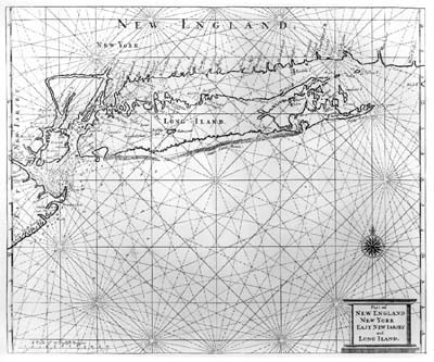 Extent: New York Harbour – Block Island |
| 62. Thornton, John Part of / NEW ENGLAND / NEW YORK / EAST NEW IARSEY / and / LONG ILAND. [5e] 421 x 515mm. From: ‘The English Pilot. The Fourth Book’ 1713 | State 2: with many additional soundings, including: from ‘Beach’ (NJ) eastwards: ‘8 10 12 16 15 15 13 14’ from ‘Renslows Hill’ (NJ) eastwards, the depths now read : ‘6 10 10 12 15 18 20 30 30 30’ |
| 63. Thornton, John PART OF / NEW / ENGLAND. / Sold by I. Thornton at y.e / Platt in the Minories. / And by Will: Fisher / at y.e Posturn gate on / Tower hill. [4d] London [4e, engraved below the title cartouche] 426 x 475mm. From: ‘The English Pilot. The Fourth Book’ 1689 | Extent: New London – Casco Bay / Kennebec River; |
| 64. Thornton, John PART OF / NEW / ENGLAND. / Sold by I. Thornton at y.e / Platt in the Minories. / And by Will: Fisher / at y.e Posturn gate on / Tower hill. [4d] London [4e, engraved below the title cartouche] 426 x 475mm. From: ‘The English Pilot. The Fourth Book’ 1706 | State 2: with additional names and soundings inserted: off ‘Montock P’ (Long Island), southeastwards: ‘9 10 10 … 16’ [2d], off ‘Bock I.’: ‘Granvill Ground’ & sounding ’18’ [2d], north-west of the title: ’50 50′ [4d], St. Georges Bank: ’45’ [4b], north of ‘Cape Codd’: ’16 18′ [3b], north of ‘St. Georges Channell’: ‘2 Cashes Ledg.’ [4b, the 2 within a circle], north-east of ‘St. Georges Channell’: ’47’ [4b], south-east of ‘Jefferys Ledg’: ’75’ [4b]. |
| 65. Thornton, John PART OF / NEW / ENGLAND. [4d] 426 x 475mm. From: ‘The English Pilot. The Fourth Book’ 1713 | State 3: another state: with the imprint erased. |
| 66. Pound, Thomas A NEW MAPP of / NEW ENGLAND / from Cape Codd to Cape Sables / Describeing all the Sands Shoals Rocks and / Difficulties together with a Sand Draft / of the Matthathussetts Bay Exactly / Surveyed by the Author Tho. Pound. / Sold by Phillip Lea at the Atlas in / Cheapside, by Will.m Court at the / Mariner and Anchor on Tower / Hill: and by George Flower / near Ratcliffe Cross. [1a] I: Harris Sculp: [4e] 2 sheets joinedmm. From: Lea, Philip Separate publication | Extent: Cape Cod – Cape Sables. |
| 67. Mount & Page A Chart of the / Sea Coast of / NEW FOUND LAND, / NEW SCOTLAND, / NEW ENGLAND, / NEW YORK, / NEW JERSEY, with / VIRGINIA and / MARYLAND. / Sold by Rich.d Mount & Tho: Page at the Postern / on Great Tower hill London. [1a] 453 x 576mm. From: Mount & Page Atlas Maritimus Novus 1702] | |
| 68. Mount & Page A Chart of the / Sea Coast of / NEW FOUND LAND, / NEW SCOTLAND, / NEW ENGLAND, / NEW YORK, / NEW JERSEY, with / VIRGINIA and / MARYLAND. / Sold by Rich.d Mount & Tho: Page at the Postern / on Great Tower hill London. [1a] 453 x 576mm. From: Mount & Page Atlas Maritimus Novus 1721 | State 2: portions of the plate have been re-engraved, particularly along the coast, where the hatching over the land, which denotes the shore-line, has been re-worked, with the length of the engraved lines extended. This is most obvious on the Cape Cod peninsula, where the hatching now covers the entire land area. |
| 69. Mount & Page A Chart of the / Sea Coast of / NEW FOUND LAND, / NEW SCOTLAND, / NEW ENGLAND, / NEW YORK, / NEW JERSEY, with / VIRGINIA and / MARYLAND. / Sold by Will:m Mount & Tho: Page at the Postern / on Great Tower hill London. [1a] 455 x 576mm. From: ‘The English Pilot. The Fourth Book’ 1732 | State 3: The imprint is the only apparent deliberate change, although the plate shows signs of wear in places. |
| 70. Seller, Jeremiah & Price, Charles A Chart of / NEW FRANCE / NEWFOUNDLAND / NEW SCOTLAND / and part of / NEW ENGLAND. / [rule] / By Jer: Seller & Cha: Price [1a] 2 [5e] 428 x 520mm. From: Seller & Price English Pilot Book Four 1703 | |
| 71. Seller, Jeremiah & Price, Charles A Chart of / NEW FRANCE / NEWFOUNDLAND / NEW SCOTLAND / and part of / NEW ENGLAND. / [rule] / [erasure] [2a] 2 [5e] 428 x 520 PM: 430 x 527mm. From: ‘The English Pilot. The Fourth Book’ 1713 | State 2: with the erasure of the imprint. |
| 72. Seller, Jeremiah & Price, Charles A / Chart of y.e Coast of / NEW ENGLAND / NEW YORK. / and / LONG ISLAND from Cape CODD / to SANDY POINT. / [rule] / By Jer: Seller & Cha: Price at the / Hermitage stairs in Wapping / LONDON. [1a] 429 x 523mm. From: Seller & Price ‘English Pilot Book Four’ 1703 | Extent: ‘Staten / Island’ [1d] to ‘C. Porpus’ [4a]. It is possible that there is a later state with the imprint erased from the title. |
| 73. Seller, Jeremiah & Price, Charles A Chart of the Coast of / NEW FOUND LAND / NEW SCOTLAND / and NEW ENGLAND &c. / By Ier: Seller and Cha. Price Hydrographers to the QUEEN / At the Hermitage staires 1703. [1a] H. Moll F. [1b] From: [Seller & Price Sea Atlas ca. 1703] | 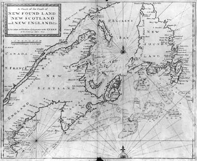 Very rare chart, extending from the Cape Cod region to Newfoundland, not listed in any of the standard carto-bibliographies. |
| 74. Cutler, Nathaniel A CHART OF THE / ATLANTICK / OCEAN / from Buttons Island / TO PORT ROYALL. [4a] 40 [4e] 589 x 577mm. From: Cutler ‘Atlas Maritimus Et Commercialis’ 1728 | 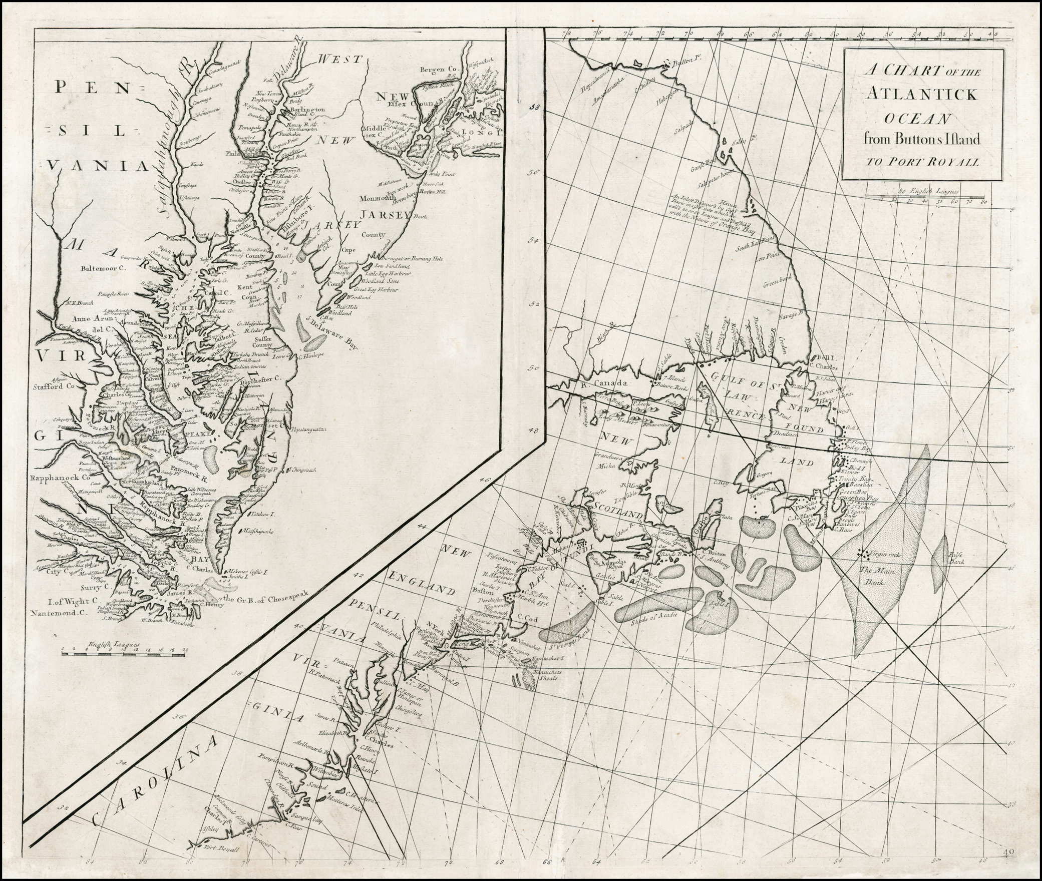 This sheet is actually the north-western of a four sheet map of the North Atlantic, but is a separate map in its own right. |
| 75. Southack, Cyprian [title-page] THE / NEW ENGLAND / COASTING PILOT / FROM / SANDY POINT of NEW YORK, / UNTO / Cape CANSO in Nova Scotia, / And Part of Island BRETON. / WITH THE / COURSES and DISTANCES from Place to Place, and / TOWNS on the Sea-Board; HARBOURS, BAYS, ISLANDS, ROADS, / ROCKS, SANDS: The Setting and Flowing of TIDES and CURRENTS; / with several other DIRECTIONS of great Advantage to this Part of Navi- / gation in NORTH-AMERICA. / [rule] / By Capt. CYPRIAN SOUTHACK, / Who has been Cruizing in the Service of the Crown of GREAT BRITAIN / Twenty-two Years. / [rule] / DIRECTIONS to Sail from the Light-house at Boston in New England / Miles / FRom the Light-house to Point ALDERTON, South by East 1 1/4 [miles] / From the Light-house to the South-East Point of EGG Rock, East half North 0 1/2 [miles] / From the Light-house to Little BRUSTERS, South East, Point North East, 1/4 East 1 1/4 [miles] / From the Light-house to GRAVE’S Rocks, North-East, 1/4 East 2 3/4 [miles] / From the Light-house to the Westermost Part Spit of Land, West half North 1 1/4 [miles] / From the Light-house to GEORGE’S ISLAND, South Part, West half South 2 [miles] / From the Light-house to RAMFORD’S ISLAND, South-East Part, West by South 3 1/4 [miles] / From the Light-house to PETICT ISLAND, North-East Part, South-West by West 2 1/4 [miles] / From the Light-house to CHAMBERLAIN’s Point of Rocks, South-West half West 1 1/4 [miles] / From PETICT ISLAND, East Part, to NANTASKET Road, North-West and by West 1 3/4 [miles] / From the Light-house to HARDIAN’S Rocks, South-East, the East Part 2 1/4 [miles] / From the Light-house to CONIHASSET Rocks, East Part, is South-East and by East 9 [miles] / From the Light-house to St. SURREN’S Rocks, West-South-West 1/4 West 1 1/2 [miles] / From the Light-house to NAHANT Rock, North by East 7 1/4 [miles] / If you come out of the Sea in the Winter Season, and there should be a great deal of Ice, my advice is to hale a-shore at / the South Part of RAMSFORD ISLAND, on the soft Ground just by NANTASKET Road; and there is no Ebb / nor Flood will do you Damage: There stay till you can get up to BOSTON. [Untitled Chart Of New England, in 8 sheets] To His Excellency / FRANCIS NICHOLSON Esq.r / Governour, Captain General and Commander in / chief, in and over His Majesty’s PROVINCE of / SOUTH CAROLINA, and Vice Admiral of y.e same; / This Chart is most Humbly / Dedicated and Presented, / By Capt. / Cyprian Southack. [sheet 1: 3b] [sheet 1: dedication & distance tables, plate number:] 1 [5e, ob]; [sheet 2: Sandy Hook, eastern Staten Island & Manhattan to the western part of Martha’s Vineyard, plate number:] 2 [5e, ob]; [sheet 3, composed of 2 half-sheets: ‘Hampton R.’, New Hampshire to ‘Mount / Desart Island & / Harbour’, plate number:] 5 [5e, ob]; [sheet 4: eastern part of ‘Marthas Vinyard I.’ to ‘Ipswich Bay’, with part of ‘S.T Georges Bank’, plate number:] 6 [5e]; [sheet 5: ‘Mount Desart / Dry Rock’ to ‘La Have Road and Harbour’, central Nova Scotia, with the western part of the Bay of Fundy, plate number:] 7 [5e]; [sheet 6: ‘Part of S.t Georges Bank’ to southern part of ‘Cape Sables Bank’, plate number:] 8 [5e, ob]; [sheet 7: eastern Nova Scotia, ‘The Island of Sable’ ‘Gut of Canso’ and the western tip ‘Part of Island Breton’, plate number] 9 [5e]; [sheet 8: the eastern ‘Part Island Breton’, plate number:] 10 [5e, ob] 1015 x 2490 overall, on 8 sheets: 1: 530 x 661 2: 532 x 625 3: 530 x 572 4: 533 x 608 5: 531 x 629 6: 533 x 631 7: 532 x 634 8: 532 x 634mm. From: Southack New England Coasting Pilot [ca. 1729] 1 | A very speculative possibility is that this map was engraved by John Senex, in London, for Southack. |
| 76. Southack, Cyprian THE / NEW ENGLAND / COASTING PILOT / FROM / SANDY POINT of NEW YORK, / UNTO / Cape CANSO in Nova Scotia, / And [manuscript: all the] Island BRETON. [manuscript: The Harbour / of Louisbourg and Forts.] / WITH THE / COURSES and DISTANCES from Place to Place, and / TOWNS on the Sea-Board; HARBOURS, BAYS, ISLANDS, ROADS, / ROCKS, SANDS: The Setting and Flowing of TIDES and CURRENTS; / with several other DIRECTIONS of great Advantage to this Part of Navi- / gation in NORTH-AMERICA. / [rule] / By Capt. CYPRIAN SOUTHACK, / Who has been Cruizing in the Service of the Crown of GREAT BRITAIN / Twenty-two Years. / [rule] / DIRECTIONS to Sail from the Light-house at Boston in New England / Miles / FRom the Light-house to Point ALDERTON, South by East 1 1/4 [miles] / From the Light-house to the South-East Point of EGG Rock, East half North 0 1/2 [miles] / From the Light-house to Little BRUSTERS, South East, Point North East, 1/4 East 1 1/4 [miles] / From the Light-house to GRAVE’S Rocks, North-East, 1/4 East 2 3/4 [miles] / From the Light-house to the Westermost Part Spit of Land, West half North 1 1/4 [miles] / From the Light-house to GEORGE’S ISLAND, South Part, West half South 2 [miles] / From the Light-house to RAMFORD’S ISLAND, South-East Part, West by South 3 1/4 [miles] / From the Light-house to PETICT ISLAND, North-East Part, South-West by West 2 1/4 [miles] / From the Light-house to CHAMBERLAIN’s Point of Rocks, South-West half West 1 1/4 [miles] / From PETICT ISLAND, East Part, to NANTASKET Road, North-West and by West 1 3/4 [miles] / From the Light-house to HARDIAN’S Rocks, South-East, the East Part 2 1/4 [miles] / From the Light-house to CONIHASSET Rocks, East Part, is South-East and by East 9 [miles] / From the Light-house to St. SURREN’S Rocks, West-South-West 1/4 West 1 1/2 [miles] / From the Light-house to NAHANT Rock, North by East 7 1/4 [miles] / If you come out of the Sea in the Winter Season, and there should be a great deal of Ice, my advice is to hale a-shore at / the South Part of RAMSFORD ISLAND, on the soft Ground just by NANTASKET Road; and there is no Ebb / nor Flood will do you Damage: There stay till you can get up to BOSTON. [Untitled Chart Of New England, in 8 sheets] To His Excellency / FRANCIS NICHOLSON Esq.r / Governour, Captain General and Commander in / chief, in and over His Majesty’s PROVINCE of / SOUTH CAROLINA, and Vice Admiral of y.e same; / This Chart is most Humbly / Dedicated and Presented, / By Capt. / Cyprian Southack. [sheet 1: 3b] 1015 x 2490 overall, on 8 sheets: 1: 530 x 661 2: 532 x 625 3: 530 x 572 4: 533 x 608 5: 531 x 629 6: 533 x 631 7: 532 x 634 8: 532 x 634mm. From: Southack New England Coasting Pilot [ca. 1729] 2 | Second ‘edition’, prepared in 1733, and published in 1734. The title has been altered in manuscript, as above. As these manuscript corrections are found on both the known examples, it would seem the corrections represent a second ‘edition’, coinciding with state 2 of themap, in which sheet 8 has been re-engraved, to insert the inset of Louisburg, following Southack’s visit there in 1733. The engraved text in the inset, relating to Louisburg, is apparently engraved by one hand, but the lettering in the second half is much darker. Inset: [Untitled Chart of Louisburg Harbour] [note] The Occasion of my drawing this Map is to shew how strong the French have Fortified / this Harbour of Louisbourg on the island Breton being all stonework. [sheet 8: 4b] ‘Minutes made in my Voyages when sent in his Maj.ties Ship Sqirrel Capt. Thomas Smart Com.r by Gov.r / by Gov.r Shute and the Hon.ble Council of y.e Massachuset bay in New England … New England October the 30.th 1733 [sheet 8:2a/3a] [key] ‘Explanation / a-i, k, L (amended in manuscript), m, n. [sheet 8: 5c] [scale] ‘The Scale of Louisburg Harbour is 300 Fathoms’ -‘300’ (76mm) [sheet 8: 4a] |
| 77. Southack, Cyprian An actual Survey of / The Sea coast from NEW YORK to the I. CAPE BRITON. / with Tables of the direct and thwart Courses & distances from Place to Place. / by CAP.T CYPRIAN SOUTHACK. / ILLUSTRATED, / with Particular Plans, of the Harbours of / NEW YORK, BOSTON, CANSO BAY & ANNOPOLIS ROYAL, / on a larger Scale. / As also / A New Chart of the ATLANTIC OCEAN. [sheet 1: 3b] Printed and Sold by W.m Herbert under the Piazzas on London Bridge & Rob.t Sayer facing Fetter Lane Fleet Street. [sheet 1: 3b] Printed for W: Herbert under the Piazzas on London Bridge. / and Rob.t Sayer opposite Fetter Lane in Fleet Street. [sheet 8: 5d] Top : 4 sheets joined 532 x 2494 / Bottom: 3 sheets joined: 534 x 1857mm. From: Herbert & Sayer Separate publication | State 3: the title has been engraved in place of the original dedication; the longitude in the border has been re-engraved, and now measures west and east of the meridian of Boston: ‘Longitude East from Boston’ & ‘Longitude West from Boston.’ New compass roses have been engraved in the sea south of Long Island [sheet 2: 4d], south of Penobscot Bay [sheet 3: 4d] west of Nova Scotia [sheet 5: 2d] and all the rhumb lines in the sea erased and re-engraved – a tremendous undertaking, done with great care. Four insets: of Casco Bay, New York Harbour, Boston Harbour and Annapolis Royal have been added. |
| 78. Southack, Cyprian An actual Survey of / The Sea Coast from NEW YORK to the I. CAPE BRITON. / with Tables of the direct and thwart Courses & distances from Place to Place. / by CAP.T CYPRIAN SOUTHACK. / ILLUSTRATED, / with Particular Plans, of the Harbours of / NEW YORK, BOSTON, CANSO BAY & ANNOPOLIS ROYAL, / on a larger Scale. / Sold by I. MOUNT, T. PAGE and W. MOUNT, Tower Hill [sheet 1: 3b] Top : 4 sheets joined 532 x 2494 / Bottom: 3 sheets joined: 534 x 1857mm. From: Mount & Page Separate publication | State 4: the imprint of Mount and Page has been inserted in the title. A new inset, of Halifax, has been inserted. The example described is on 7 sheets only, lacking sheet 8, with the inset map of the North Atlantic. Two examples in the Library of Congress also lack sheet 8, while another has the key map to Henry Popple’s map of the British Empire inserted. A fourth example, in a Boston private collection, comprises only the four western sheets, but is as issued, laid on the original canvas, with the original wooden rollers. Evidently, the original purchaser was interested in acquiring only that section of the map showing the coastline between New York and Boston. |
| 79. Senex, John A Map of the Coast of / NEW ENGLAND / from Staten Island to the / Island of Breton; / as it was actualy Survey’d / by Cap.t Cyprian Southack. / Sold by Iohn Senex at the Globe overagainst S.t Dunstans Church in / Fleetstreet: who also makes & Sells Globes & Maps w.th new improvements. [5b] 2 sheets joined.. From: Senex Separate publication | 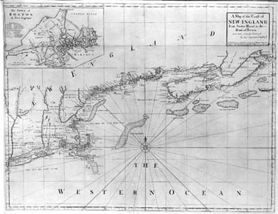 Extent: New York Harbour – Nova Scotia. |
| 80. Senex, John A Map of the Coast of / NEW ENGLAND / from Staten Island to the / Island of Breton; / as it was actualy Survey’d / by Cap.t Cyprian Southack. / Sold by Iohn Senex at the Globe overagainst S.t Dunstans Church in / Fleetstreet: who also makes & Sells Globes & Maps w.th new improvements. [5b] 610 x 1087 3 sheets joined. From: Senex Separate publication | State 2: A third sheet has been added, extending the coverage of the map eastwards, so the map now extends from New York Harbour to western Newfoundland. Furthermore, the original sheets have additions, including a new inset, and a scale bar. The inset of Boston remains, with the outer border widened. Some re-engraving has occurred in Nova Scotia (described below), while the original graduated border of the second sheet has been replaced by a single line border, without graduations, visible in subsequent states. The additional sheet shows Cape Breton I. (with an inset of Louisburg) and part of Newfoundland. ‘Island Breton’ has ben erased ans ‘THE / ISLAND OF / BRETON’ and ‘PART OF NEW / FOUND LAND’ added. Consistent with this, Senex made a number of minor changes in Nova Scotia, (now named ‘ACCADIA OR NOVA SCOTIA’), including the insertion of trees, and added soundings in the sea, below the title. |
| 81. Senex, John A Map of the Coast of / NEW ENGLAND / from Staten Island to the / Island of Breton; / as it was actualy Survey’d / by Cap.t Cyprian Southack. / London Printed for W.m Herbert at the Globe on London Bridge, and / Rob.t Sayer opposite Fetter Lane Fleet Street. [5b] 2 sheets joined. From: Herbert & Sayer Separate publication | 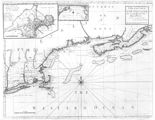 State 3: This re-issue omits the third sheet, covering Cape Breton. The map appears unchanged from the previous state, with the only alteration being the imprint. |
| 82. Senex, John A Map of the Coast of / NEW ENGLAND / from Staten Island to the / Island of Breton; / as it was actualy Survey’d / by Cap.t Cyprian Southack. / Sold by I. Mount, T. Page & W. Mount. Tower Hill. / LONDON. [5b] 2 sheets joined.. From: Mount & Page Separate publication | 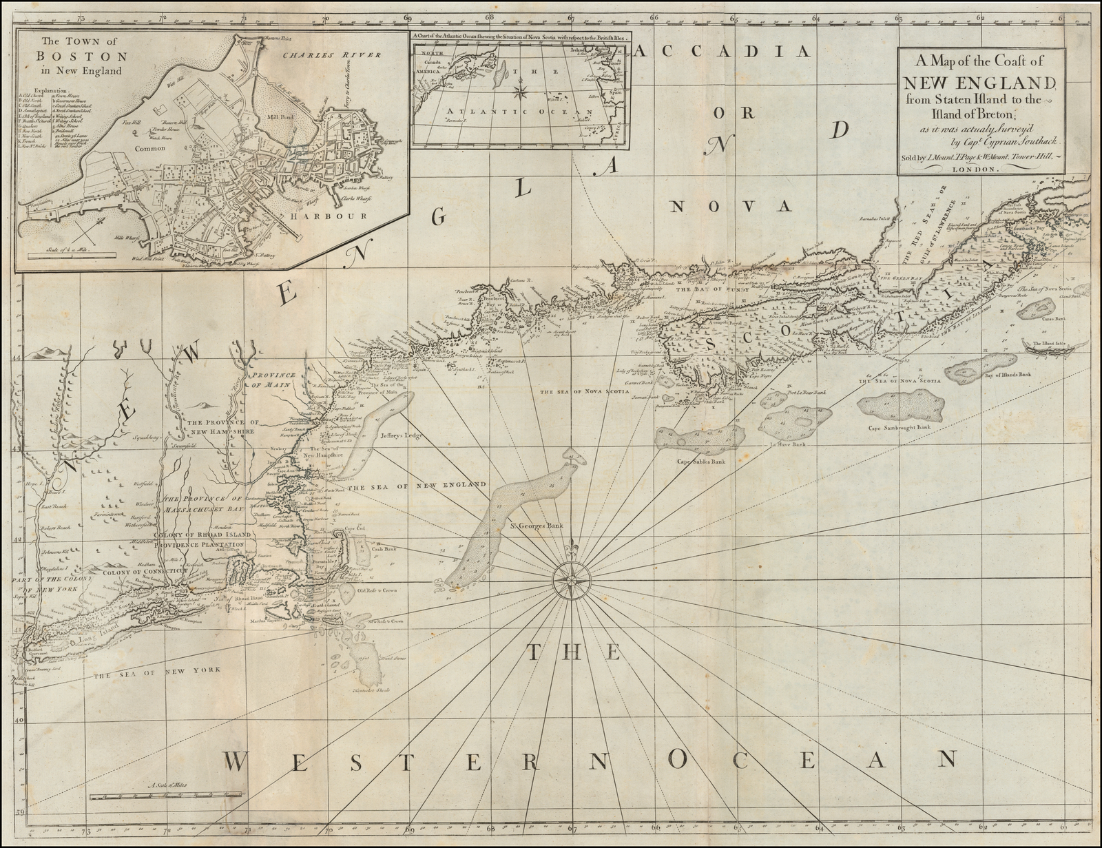 State 4: added to the ‘English Pilot. The Fourth Book’ in 1775, and used in all subsequent editions of the atlas (to 1794). Once again, apart from the altered imprint, the plate is apparently unchanged. |
| 83. Mount & Page A / Correct Map of the Coast / OF / NEW ENGLAND. / 1731. [4d] 471 x 1093 Inset: 265 x 252mm. From: ‘The English Pilot. The Fourth Book’ 1732 | Extent: Sandy Hook to Cape Breton Island; |
| 84. Mount & Page A / Correct Map of the Coast / OF / NEW ENGLAND. [4d] 466 x 1069mm. From: ‘The English Pilot. The Fourth Book’ 1749 | 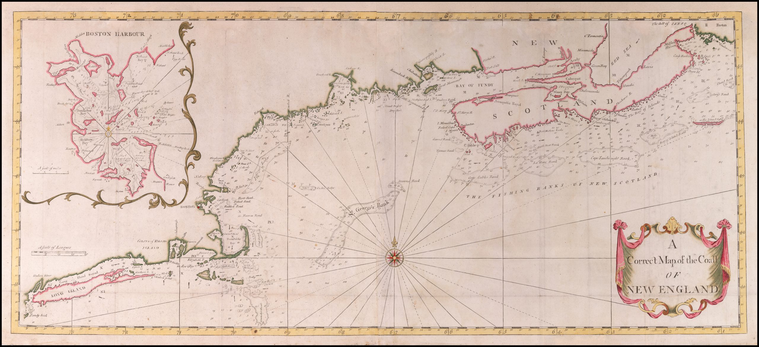 State 2: with the date erased from the title. Within the chart are a number of additions: ‘THE FISHING BANKS OF NEW SCOTLAND’ [4c] ‘NEW / SCOTLAND’ [5b], and current arrows added the face of the chart. Soundings and anchors have been added in Long Island Sound, west of Fishers Island, as the ‘X 1/4’ and ‘X. Sandbanks have been added to the shore of the Cape Cod peninsula [2d], rocks added to the Massachusetts coast between Banstable Bay and Point Alderton [south of Boston, 2d], ‘Harts Bank’ ‘Pollocks Bank’, ‘Haddock Bank’ and ‘Cod Bank’, outside Boston Harbour [2c], all the soundings along the coast from Cape Cod to the Bay of Fundy [2b-4d], along the eastern edge of ‘Jefferys Bank’ [2c], west and south of ‘Cashes Ledge’, (between ‘Jefferys Bank and St. George’s Bank’ [2c]. Mount Desart Island is now named ‘Mount Desart / dry Rock’ [3b], ‘Kennebeck R.’ and ‘Chibutton’ named [3b], the St. John’s River extended inland, and ‘Fort Salt’ added at the mouth [4b], ‘C. Enrage’, ‘Padas River’ with two symbols [4b]. ‘Accady’ is now shown, and the original engraved coastline across the end of the peninsula erased [4b]. On the ‘Red Sea’ [4a], ‘C. Tormentin’,’Mirimachi’, ‘Tatemagouch’, ‘Mauchi’ and ‘Lovis’ are named, on Nova Scotia, additional names include ‘Milford Haven’ ‘Ponbonton’, ‘Basques’, ‘Minas’ ‘Mission’ and ‘Chebenarcadie’ [4b]; along the coast of Nova Scotia, ‘I. Mouilloues’, ‘Forked Cape’, ‘I. Moors’, ‘Cape Sable’, ‘Bay of Chibouetou’, ‘Cape Theodore’, ‘Ducks I.’, ‘Green I’, ‘Bart H.’ named [4b]; on Cape Breton Island, ‘P.t Toulouze’ [5a] |
| 85. Mount & Page A / Correct Map of the Coast / OF / NEW ENGLAND. [4d] 466 x 1069mm. From: ‘The English Pilot. The Fourth Book’ 1773 | State 3: the plate has been reworked, to strengthen the coastline, without reworking the shading along the landward side. This is most noticeable for Martha’s Vineyard and Nantucket Island. |
| 86. Mount & Page A CHART / of the SEA COAST of / NEW FOUNDLAND / NEW SCOTLAND / NEW ENGLAND / NEW YORK / NEW JERSEY with / VIRGINIA and / MARYLAND. / [scale bar] / Sold by W. & I. Mount & T. Page } / on Tower Hill LONDON. } [1a, on a curtain / banner design] mm. From: ‘The English Pilot. The Fourth Book’ 1748 | |
| 87. Mount & Page A CHART / of the SEA COAST of / NEW FOUNDLAND / NEW SCOTLAND / NEW ENGLAND / NEW YORK / NEW JERSEY with / VIRGINIA and / MARYLAND. / [scale bar] / Sold by W. & I. Mount & T. Page } / on Tower Hill LONDON. } [1a, on a curtain / banner design] 450 x 569mm. From: ‘The English Pilot. The Fourth Book’ 1751 | 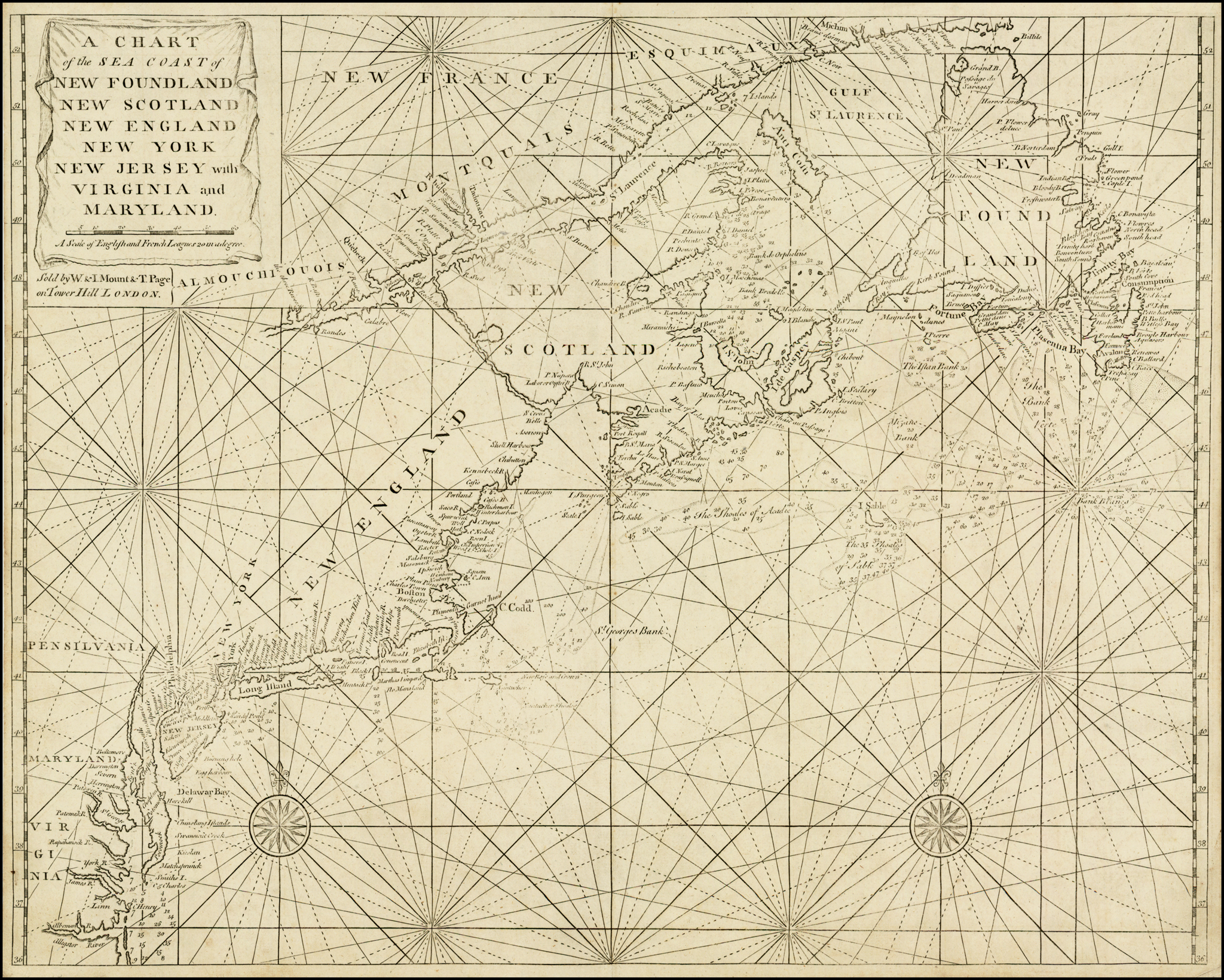 State 2: The northern edge of the Grand Banks has been re-engraved, so that it now extends to Cape Race, on Newfoundland [5b], in the previous state, the northern edge ran west-east just below the 46 degree latitude mark. |
| 88. Mount & Page A CHART / of the SEA COAST of / NEW FOUNDLAND / NEW SCOTLAND / NEW ENGLAND / NEW YORK / NEW JERSEY with / VIRGINIA and / MARYLAND. / [scale bar] / Sold by W. & I. Mount & T. Page } / on Tower Hill LONDON. } [1a, on a curtain / banner design] 450 x 569mm. From: ‘The English Pilot. The Fourth Book’ 1773 | State 3: The plate has been extensively re-worked. The banner behind the title has been re-worked, with the shading of the lower fringe more structured. In the scale bar, the unit 0 to 10 have been divided into six smaller units, but the other units are not changed. The bank of ‘Banc des Orphelins’ is engraved behind the name, rather than to the left, and stippled for the first time [4b]. The bank of ‘Bank Bradelle’ is also engraved behind the name, instead of to the lower left, and is much enlarged, as well as being stippled for the first time. The shoal off the southern end of Anticosti has not been recut, and has disappeared [4b], as have the smaller shoals around Nantucket Island (leaving only ‘Nantuker Shoals’) [2d], Long Island, New Jersey, Delaware Bay, and the Delmava peninsula. Subsequent issues show continued deterioration of the image, with many of the shoals along the southern New England coastline gradually fading out. Verner, A Carto-Bibliographical Study of the English Pilot, p.47-9; |
| 89. Grierson, George A Chart of the / Sea Coast of / NEW FOUND LAND / NEW SCOTLAND / NEW YORK / NEW JERSEY with / VIRGINIA and / MARYLAND / and New England / Sold by George Grierson at the two / Bibles in Essex Street Dublin. [1a] 450 x 565mm. From: Grierson’s English Pilot. Fourth Book 1749 | |
| 90. Grierson, George A Large Draught / of / NEW ENGLAND / NEW YORK AND / LONG ISLAND. / [double rule] / Sould By George Grierson / at the two Bibles in Essex Street / Dublin. [3a] 440 x 549 Inset: 260 x 230mm. From: Grierson’s English Pilot. Fourth Book 1749 | 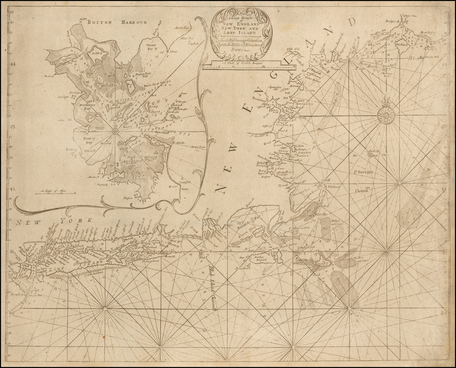 Extent: Penobscot Bay – Sandy Hook. |
| 91. Bellin, Jacques Nicolas CARTE REDUITE DES / COSTES ORIENTALES DE / L’AMERIQUE SEPTENTRIONALE / 1.re Feuille contenant / L’ISLE ROYALE, L’ACCADIE, LA BAYE FRANCOISE, / LA NOUVELLE ANGLETERRE ET LA NOUVELLE YORC. / Dressée au Depost des Cartes et Plans de la Marine / Pour le Service des Vaisseaux du Roy. / Par Ordre de M. DE MACHAULT Garde des Sceaux de France / Ministre et Secretaire d’Etat ayant le Departement / de la Marine. / M DCC LVII. / Par M. Bellin Ing.r de la Marine et du Depost / des Plans de l’Academie de Marine et de / la Societe Royale des Londres. [2b] 543 x 887 Inset: 172 x 220 PM: 584 x 924mm. From: Hydrographie Francois [1757-] | Extent: New York Harbour – Cape Breton Island |
| 92. Bellin, Jacques Nicolas CARTE REDUITE DES / COSTES ORIENTALES DE / L’AMERIQUE SEPTENTRIONALE / 1.re Feuille contenant / L’ISLE ROYALE, L’ACCADIE, LA BAYE FRANCOISE, / LA NOUVELLE ANGLETERRE ET LA NOUVELLE YORC. / Dressée au Depost des Cartes et Plans de la Marine / Pour le Service des Vaisseaux du Roy. / Par Ordre de M. DE MACHAULT Garde des Sceaux de France / Ministre et Secretaire d’Etat ayant le Departement / de la Marine. / M DCC LVII. / Par M. Bellin Ing.r de la Marine et du Depost / des Plans de l’Academie de Marine et de / la Societe Royale des Londres. [2b] [with the Depot de la Marine stamp] [2d] N.o 65 [5a, ob] Prix. trente Sols. [1e, ob] 543 x 887 Inset: 172 x 220 PM: 584 x 924mm. From: Hydrographie Francoise [1757-] | 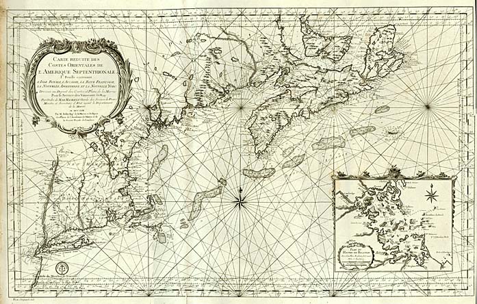 State 2: the original network of rhumb lines has been erased, and a new set engraved, emanating from a compass rose east of Cape Cod [3e], and two other focal points, west of Nova Scotia [3b] and south-east of Cape Breton Island [4d]. The new series of rhumb lines runs over the inset of Boston Harbour. |
| 93. Barnsley, Henry A NEW AND CORRECT / CHART / of the Sea Coast of / NEW-ENGLAND, / From Cape Codd to Casco Bay, / Lately Survey’d by / Cap.t Henry Barnsley. / [rule] / Sold by W. & I. Mount & T. Page on / Tower-hill LONDON. [1a] 474 x 1168 PM: 489 x 1184mm. From: ‘The English Pilot. The Fourth Book’ 1764 | Extent: Cape Cod – Casco Bay. The plate was superceded in the ‘Fourth Book’ by Mount and Page’s re-issue of Senex’s two-sheet chart (state IV) in 1775, but re-appeared in the edition of 1794, so that the final edition of the ‘Fourth Book’, contained two general charts of New England. |
| 94. Barres, Joseph Frederick Wallet des THE COAST / of / NEW ENGLAND. [[5d] 744 xmm. From: Des Barres ‘Atlantic Neptune’ Vol. II 1777 | Extent: Passamaquody Bay to Rhode Island; State 1: the sand-banks are unstippled. |
| 95. Barres, Joseph Frederick Wallet des THE COAST / of / NEW ENGLAND. [5d] 744 xmm. From: Des Barres ‘Atlantic Neptune’ Vol. II 1777 | State 2: with the addition of stippling on the shoals. |
| 96. Barres, Joseph Frederick Wallet des THE COAST / of / NEW ENGLAND. [5d] [note] Note The Soundings and Nautical Remarks inthis Chart / are lad down from the Observations of Lieutenant / Knight of the Navy and Pilots. [5d] 744 xmm. | State 3: with the addition of the note crediting Knight, under the title. |
| 97. Barres, Joseph Frederick Wallet des THE COAST / of / NEW ENGLAND. [5d] [note] Note The Soundings and Nautical Remarks inthis Chart / are lad down from the Observations of Lieutenant / Knight of the Navy and Pilots. [5d] 3 [5e, in border] 744 x 1070mm. | 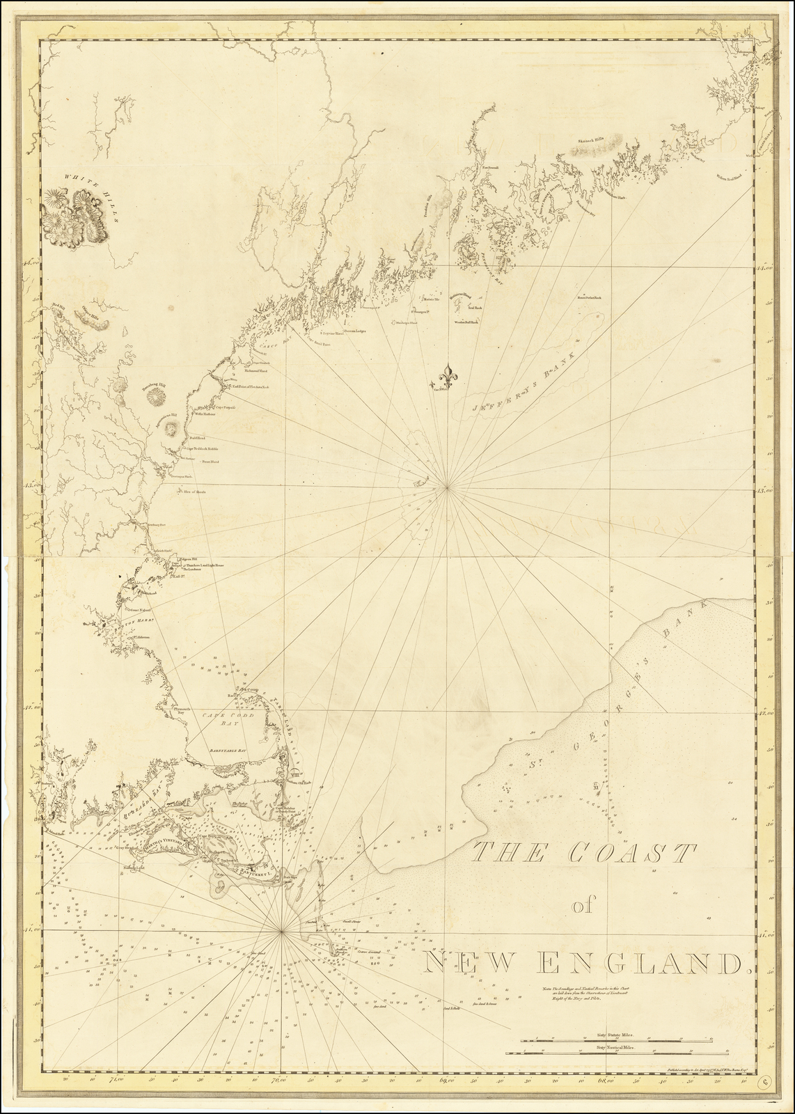 State 4: with the plate number added. Sellers & van Ee, 820: noting 5 states; |
| 98. Barres, Joseph Frederick Wallet des THE COAST / of / NEW ENGLAND. [5d] [note] Note The Soundings and Nautical Remarks in this Chart / are laid down from the Observations of Lieutenant / Knight of the Navy and Pilots. [5d] 3 [5e, in border] Top: 532 x 744 B: 535 x 742mm. From: Des Barres ‘Atlantic Neptune’ Vol. II 1781 | State 5: with the date in the imprint re-engraved. |
| 99. Depot CARTE RÉDUITE / DES CÔTES ORIENTALES / DE L’AMÉRIQUE SEPTENTRIONALE. / CONTENANT / Celles des Provinces de New-York et de la Nouvelle Angleterre. / celles de l’Acadie ou Nouvelle Escosse, de l’Isle Royale de l’Isle S.t Jean / avec l’intérieur du Pays. / Dressée au Dépôt Général des Cartes, Plans et Journaux de la Marine / POUR LE SERVICE DES VAISSEAUX DU ROI. / Par Ordre de M. DE SARTINE, Conseiller d’Etat, / Ministre et Secretaire d’Etat ayant le Département / de la Marine. / 1780. [1a] Petit sculp. [1e, ob] PRIX Trois Livres. [5e, ob] [engraved stamp] ‘DEPOT GENERAL DE LA MARINE’ [5e] 1. [5a, ob] 584 x 685 PM: 606 x 674mm. From: Neptune Americo-Septentrional [1780] | Extent: Long Island to Cape Breton, with the southern shore of the Gulf of St. Lawrence to ‘Baie de Chaleurs’, with the south-western tip of Newfoundland. |
| 100. Depot CARTE RÉDUITE / DES CÔTES ORIENTALES / DE L’AMÉRIQUE SEPTENTRIONALE. / CONTENANT / Celles des Provinces de New-York et de la Nouvelle Angleterre. / celles de l’Acadie ou Nouvelle Escosse, de l’Isle Royale de l’Isle S.t Jean / avec l’intérieur du Pays. / Dressée au Dépôt Général des Cartes, Plans et Journaux de la Marine / POUR LE SERVICE DES VAISSEAUX DU ROI. / Par Ordre de M. DE SARTINE, Conseiller d’Etat, / Ministre et Secretaire d’Etat ayant le Département / de la Marine. / 1780. [1a] Petit sculp. [1e, ob] PRIX Trois Livres. [5e, ob] [engraved stamp] ‘DEPOT GENERAL DE LA MARINE’ [5e] 1. [5a, ob] N.o 1 (Hyd. N.o 61) 584 x 685 PM: 606 x 674mm. From: Neptune Americo-Septentrional [1780] | State 2: with the plate number re-engraved. |
| 101. Keulen, Gerard Hulst van A NEW CHART / OF THE COAST OF / NEW ENGLAND, NOVA SCOTIA / and the ISLANDS of / S.T JOHN, CAPE BRETON, SABLE, / THE BANKS OF S.T / PETERS, MIZEN, BANQUEREAU, PORPOISE, / MIDDLE, SABLE ISLAND, BROWNS, CAPE SABLE, IEFFERYS, / and with Part of S.T GEORGES BANK; / These Chartz are Followed, according tho them Executed / by ORDER of the LORDS COMMISSIONERS, of the / ADMIRALTY in ENGLAND: To be / Sold at AMSTERDAM By / G. HULST van KEULEN. / Anno 1784. [2a] 605 x 1103 Inset (ib): 255 x 260mm. From: Van Keulen ‘Zee-Karten Van Noord-America’ 1785 | Extent: ‘Rhode Island H.r’ to ‘CAPE BRETON ISLAND, with the southern shore of the Gulf of St. Lawrence, including ‘S.T IOHN’S ISLAND’ and ‘S.T PETER’S BANK’ off Newfoundland |
| 102. Keulen, Gerard Hulst van THE COAST / of / A PART OF NEW ENGLAND, NEW / YORK, NEW JERSEY, PENSILVANIA, / MARYLAND, VIRGINIA, AND PART OF / NORTH CAROLINA &c. / WITH THE / BANKS, ROKS, SOUNDINGS, SHOALS, CURRENTS, / & NAUTICAL REMARKS, COMPOSED from a Great / Number of ACTUAL SURVEYS and other / MATERIALS. / These Charts are Followed, according to them Executed / by order of the Lords Commissioners, of the ADMIRALTY / in ENGELAND, to be Sold at AMSTERDAM. / By GERARD HULST VAN KEULEN. / Anno 1784. [1a] 617 x 1095 Inset (ib): 370 x 410mm. From: Van Keulen ‘Zee-Karten Van Noord-America’ 1785 | ‘BOSTON BAY’ to ‘CAPE HATTERAS’ |
NOTES
1. quoted by Lowery, Descriptive List of Maps Of The Spanish Possessions In The United States, (Washington: Government Printing Office, 1912), p.124.
2. Stokes, I.N. Phelps The Iconography of Manhattan Island, (Reprint edition; New York: Martino Fine Books, 1998), II, p.99-100.
3. C.PL. 37 depicts the two engraved charts, C.PL.36, the manuscript original of the eastern seaboard chart.
4. Stokes, do., II, p.101-2.
5. Stokes, do, II, p.99.
6. Koeman, Dr. I.C. Atlantes Neerlandici, (Amsterdam: Theatrum Orbis Terrarum, 1970), p.115.
7. Koeman, do., p.115.
8. Koeman, do, p.15: Alp 1, notes.
9. Koeman, do, p.164.
10. Koeman, do. p.152.
11. Campbell, Tony ‘The Jansson-Visscher Maps of New England’, Chapter 8 of R.V. Tooley, ‘The Mapping of America.’ (London: Holland, Press 1980) Lowery, 133.
12. Le Gear, Clara Eli ‘The New England Coasting Pilot of Cyprian Southack’, IM XI (Reprint edition; Amsterdam: Nico Israel, 1967), p.137ff.