A review and summary of Jean Boisseau’s folio atlas output
(Theatre des Gaules and Theatre Geographique)
including details of an hitherto unrecorded “first” atlas published by Boisseau in 1637.
BY JOSEPH Q. WALKER
Jean Boisseau, a Parisian map publisher, is recorded as a “master illuminator” in 1631 and a “map colourist” from 1635 – Enlumineur de cartes marines / Enlumineur du Roy pour les cartes geographiques. Boisseau published his first map Diocese d’Aire in 1635, and a number of his own maps from 1636. However, Mirielle Pastoureau in Les Atlas Francais lists only one edition of Boisseau’s atlas Theatre des Gaules, dated 1642.
This 1642 edition of Boisseau’s Theatre des Gaules is effectively a continuation of Jean le Clerc’s Theatre Geographique. At some stage between 1632 and 1641, Boisseau is known to have acquired Jean le Clerc’s map plates from Le Clerc’s widow.
A later 1648 edition of Boisseau’s atlas has also been recorded –
1648 Theatre Geographique ….
This 1648 edition was referred to by L. Loeb Larocque in 1990 in his contribution to the Liber Amicorum to N. Israel. (Copy in Loeb Larocque private collection then).
Another (dispersed) copy can be inferred from Tooleys Catalogue in 1981 (Cat. 2, item 19).
Pastoureau records that “Boisseau…tres actif jusque’en 1648…disparait ensuite sans laisser
d’heritiers.” However, copies of individual Boisseau maps dated in the 1650’s are known.
From the French state archival records, he still appears to have been active in 1657, receiving permission to publish “un livre de geographie administrative.”
Boisseau’s Publishing Activity (pre-1642)
Boisseau’s earlier publishing activities, before 1642, are not well documented. Pastoureau reflects that Boisseau “reste quelque peu mysterieux“.
Pastoureau describes two editions of Le Clerc’s Theatre Geographique (Le Clerc F & H), at least one of which can better be described as an edition published by Boisseau, after his acquisition of Le Clerc’s plates.
1641 (Past. H) [1644 ?]
This 1641 edition uses the title page from Le Clerc’s widow’s 1632 edition of the Theatre Geographique (her last), but with an additional label pasted over the bottom half of the title page, dated 1641, and clearly indicating that Boisseau was the publisher of this atlas. The only recorded copy of this edition in the Bibliotheque Nationale contains nine views of towns from Boisseau’s Theatre des citez, some with later dates, viz 1643 (3) and 1644 (1). These town views suggest a later binding of this particular example of his 1641 atlas, indicating an issue date c. 1644.
This example contains a full set of Le Clerc’s 52 maps as last published by Le Clerc’s widow in 1632 (except that in this 1641 (1644) “Boisseau” atlas, the World map by Le Clerc is dated 1633). It also contains the four continents by Bertius / Tavernier (1627) which were also included by Le Clerc’s widow in her 1632 atlas, suggesting that this 1641 atlas may have been assembled at least in part by Boisseau from printed stock acquired by him.
It is conceivable that Boisseau produced this atlas from stock of bound copies acquired by him, with his own town views being inserted retrospectively in spare guards and with a Boisseau label pasted on the title page.
1631 (Past. F) [1647]
This edition uses the title page from Le Clerc’s widow’s 1631 edition of the Theatre Geographique. However, the map content of the atlas, with many maps with Boisseau’s name, with one dated as late as 1647, clearly suggests that this atlas was published by Boisseau around 1647, using an old title page of Le Clerc’s widow.
In the only recorded copy of this atlas, there are no obvious signs of a pasted over Boisseau label having been present and subsequently removed, but it is possible that a pasted over label was originally there, or was intended to be there.
A detailed study of plate cracks on some of the “Le Clerc” maps in this 1631 [1647] issue confirms that they were printed later than those in the 1641 [1644] edition above.
Discovery of a hitherto unrecorded 1637 edition of Jean Boisseau’s Theatre des Gaules
Recently, the author was kindly given the opportunity to examine a two-volume composite atlas in a private collection. This atlas, from its title page on Tome I, appears to be a hitherto unrecorded 1637 edition of Jean Boisseau’s Theatre des Gaules.
T H E A T R E D E S G A V L E S OV DESCRIPTIONS GENERALES ET PARTICVLIERES DE TOVTES LES PROVINCES DV ROYAVME DE FRANCE, auec les Prouinces & Estats circonuoisins. A PARIS, Chez IEAN BOISSEAV, Enlumineur du Roy pour les Cartes Marines & Geographiques, en l’Isle du Palais, a la Fontaine de Iouuence M. DC. XXXVII
Tome 1 (with unrecorded 1637 Title Page for Boisseau’s Theatre des Gaules)
This unrecorded 1637 Title Page for Boisseau’s Theatre des Gaules, suggests that this atlas pre-dates Boisseau’s other atlas productions described above, and reflects Boisseau’s first effort at atlas production, before he had many maps of his own and before he had acquired Le Clerc’s plates – with Boisseau using map sheets from other mapmakers and in particular from Christophe Tassin.
Tassin first published his maps in his own atlas Cartes Generale de Toutes Les Provinces de France in 1634, with an enlarged second edition in 1637 (France, royaumes et provinces d’Europe).
Another French map publisher, Melchior Tavernier, used some Tassin maps in his own atlas production (Theatre Geographique 1634, 1637, 1638 ?, 1643). Tassin sold his plates to Antoine de Fer and Nicolas Berey in 1644. Mariette later used Tassin maps in his Theatre Geographique. Tassin also delegated the publication of several of his other atlases between 1633 and 1638 simultaneously to various map publishers in Paris (Gobert, Messager, van Lochom, M. Tavernier and Cramoisy).
In that overall context, it seems reasonable to presume that Boisseau used Tassin’s maps as the basis for his earliest atlas publication.
The only other explanation would seem to be that someone has combined a copy of Tassin’s own 1637 atlas (Pastoureau IIB), with a collection of other contemporary miscellaneous maps. However, this would not explain the existence of the Boisseau Theatre des Gaules 1637 title page. (Boisseau would have had to have used somebody else’s maps in his 1637 atlas, as he did not have his own maps of France at that time).
The title page of Boisseau’s 1637 Theatre des Gaules is different from his 1642 title page. The typefaces have been set slightly differently and they have a different address / description (and date).
Eight of Tassin’s maps, published in his own 1637 atlas, are not included by Boisseau in this atlas, viz Tassin’s Carte de France (Boisseau has no specific replacement for this general map); Touraine (Boisseau uses the Bouguereau / Le Clerc map); Pais Bas and Hollande (both replaced by one map – Boisseau’s / Meufves own Pais Bas map), and Tassin’s 4 maps covering Lorraine et Bar (replaced by 2 maps by Bouguereau / Le Clerc).
This example of Boisseau’s 1637 Theatre des Gaules (Tome 1) contains a total of 76 maps (in 75 folio pages) [coincidentally, almost exactly the same number as his 1642 edition in the BN, based on Le Clerc’s plates].
The 75 folio maps in Tome 1
| By Mapmaker | By Area | ||
| Tassin | 39 | France | 45 |
| Bouguereau / Le Clerc | 3 | Other Europe | 29 |
| Le Clerc | 6 | World | 1 |
| Boisseau / Meufves | 5 | ||
| van Lochom | 1 | ||
| H. Hondius | 12 | ||
| H. Hondius / M. Tavernier | 2 | ||
| Jansson | 3 | ||
| Mercator | 1 | ||
| Visscher | 3 |
The Tassin maps are all undated. Only 12 of the other maps are dated, 11 between 1624 – 1636, with one (Boisseau) map dated 1639, suggesting an actual date of issue of 1639 for this example.
Tome 2 (without title page)
This untitled volume, in a matching re-binding to Tome 1, contains 64 maps covering a wide range of other countries around the world. The latest map is dated 1637 (Boisseau).
The 64 maps in Tome 2
| Boisseau / Meufves | 5 | Jansson | 29 |
| Tassin | 9 | Mercator/Hondius | 12 |
| M. Tavernier | 1 | Blaeu | 4 |
| van Lochom | 1 | Dankerts | 1 |
| anon (celestial) | 1 | Visscher | 1 |
It seems reasonable to conclude that this second volume was designed to complement Tome 1, and was put together at the same time, probably by Boisseau as a map publisher and seller.
Individual Maps
World
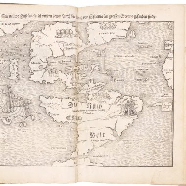
The World map in Tome I of Boisseau’s Theatre des Gaules of 1637 [1639] is M. van Lochom’s map of 1636, engraved by Henry Le Roy. [This map is reported by Shirley to appear in some 1637 (Admiralty Library London, Vb 11) and 1640 editions of Tassin’s atlas (this occurrence is not listed in Pastoureau).]
Boisseau’s own world map of 1636, Nouvelle et Exacte Description de la Terre Universelle…par I.B., does not appear in Tome 1 or Tome 2. This map first appears in Boisseau’s 1642 Atlas and also in Boisseau’s 1641 [1644 ?] publication of the Theatre Geographique described earlier.
In Tome 2, Boisseau’s own double spherical world map appears, Nouvelle description de tout la terre, which keys the world religions. This map is undated, but is dated by Shirley c. 1640.
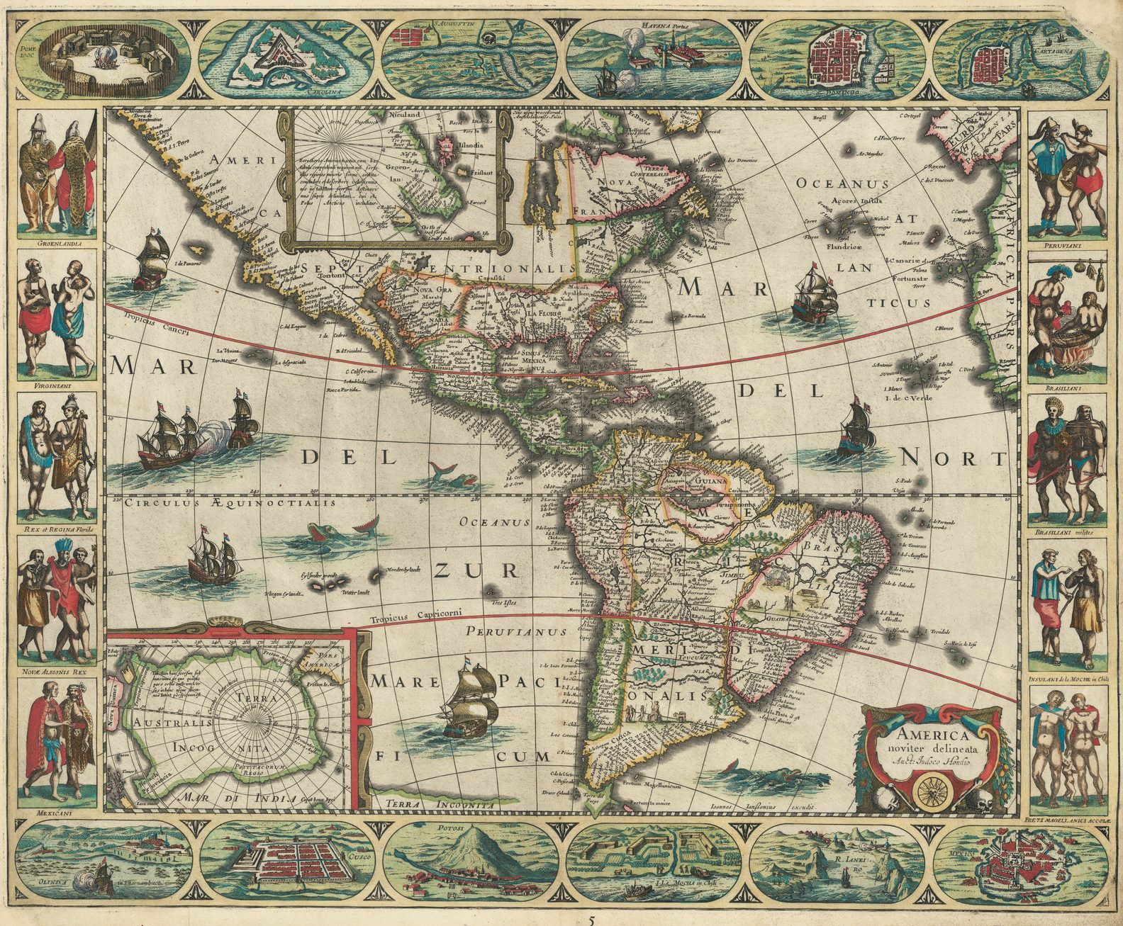
America
The map of America in Tome 2 of Boisseau’s Theatre des Gaules of 1637 [1639] is Boisseau’s own map AMERICA noviter delineata … Auct. Judoco Hondio engraved by H. Picart. (Boisseau did not sign this map).
This map is given the date of c. 1636 by Burden, in line with Boisseau’s maps of the world and other continents. [Boisseau’s Europe map, dated 1636, appears in Tome 1 of this 1637 edition of Theatre des Gaules.]
This map of America appears in Boisseau’s 1642 atlas, but has so far not been recorded in any publication prior to that date.
This 1637 [1639] atlas is probably the earliest recorded publication of this map of America in an atlas.
Boisseau’s Own Maps
A total of 10 Boisseau maps appear in this atlas.
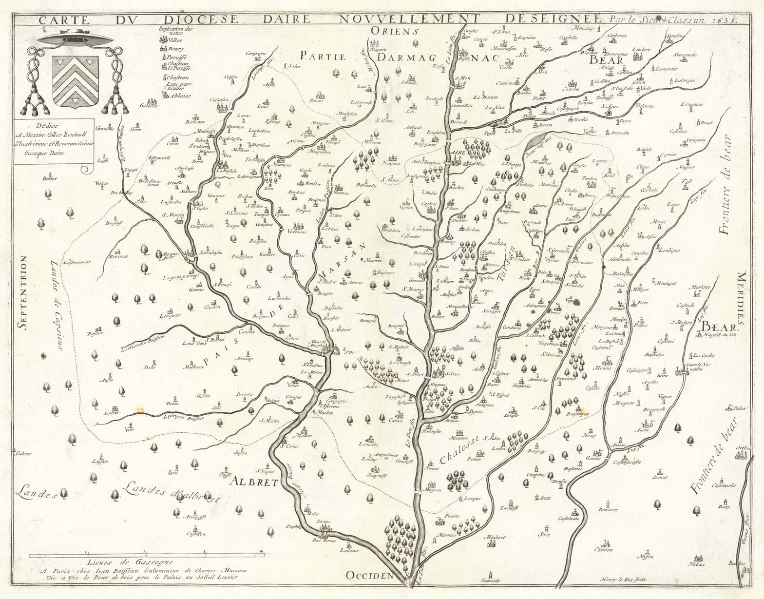
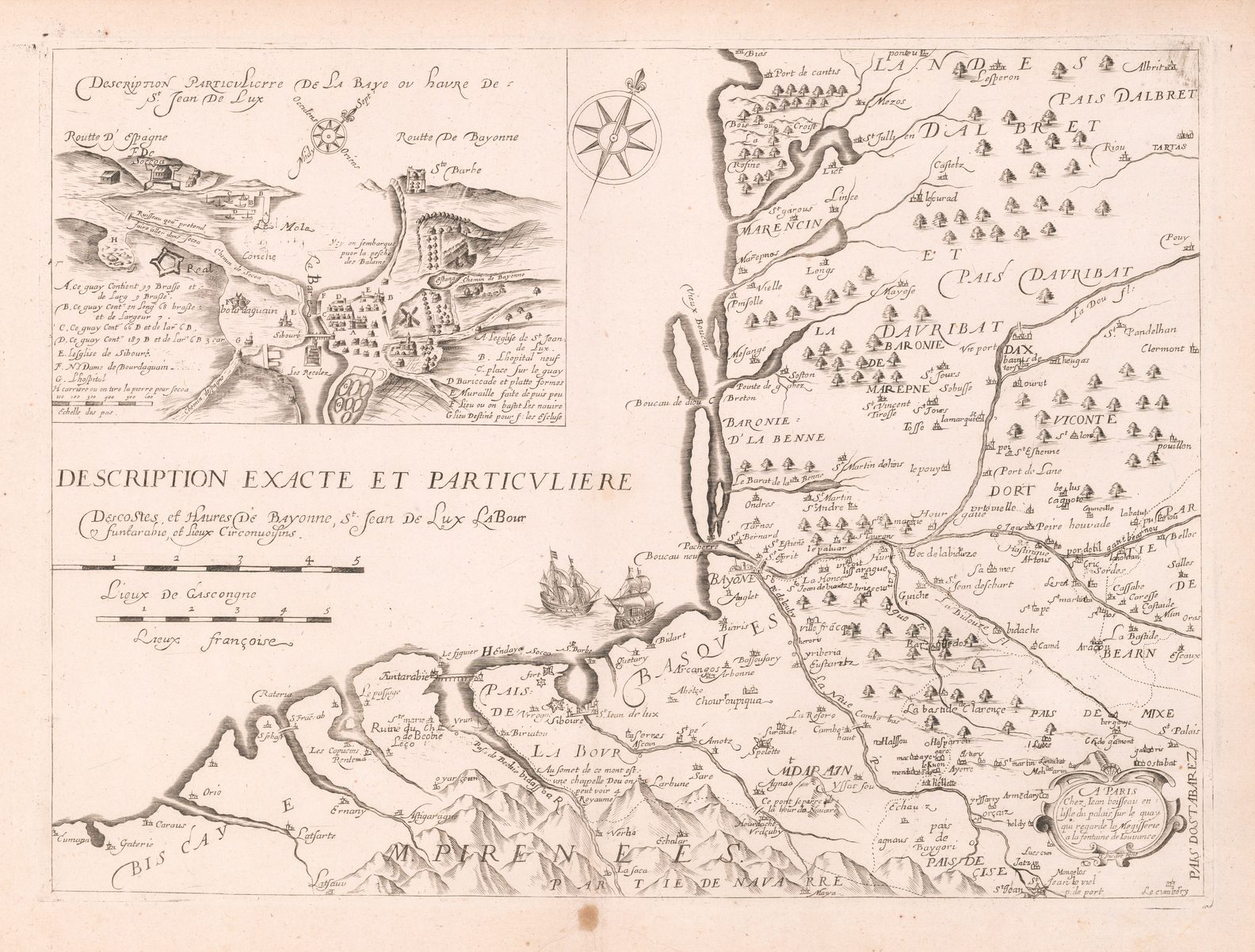
In Tome 1 are his first map Diocese d’Aire 1635, Pais Bas 1636, Europe 1636, Costes de Havres de Bayonne (undated) and Comte de Rousillon 1639.
In Tome 2 appear his three other maps of the Continents Africa, Asia and America, plus his Description de la terre (Scripture lands) engraved by Picart and dated 1637 and his World (Religions) map described above.
All of these Boisseau maps (except the “Scripture lands” map) also appear in the 1642 edition of the Theatre des Gaules.
The fact that the set of four continents are split between the two volumes and that Europe is in the first volume preceding the maps of France supports the view that these two volumes were prepared as one entity.
Summary
It seems likely that this is a copy of Boisseau’s earliest atlas production Theatre des Gaules 1637 (1639) and is previously unrecorded.
This 1637 (1639) atlas is probably the earliest recorded publication of Boisseau’s map of America in an atlas.
This atlas is based on Tassin’s map sheets, plus a range of cartes hollandaises, predominantly Mercator / Hondius / Jansson, plus 10 Boisseau maps in total.
Both volumes appear to have been published / sold as one entity.
It would appear that Boisseau acquired Le Clerc’s map plates between 1637 (1639?) and 1641. Prior to his acquisition of Le Clerc’s map plates, Boisseau, like other Parisian map publishers at the time used some Le Clerc maps in making up his Atlases.
A total of 5 folio atlases are now known to have been published by Jean Boisseau. These atlases (listed below) were published between 1637 and 1648, substantially extending the period of Boisseau’s known folio atlas publishing activities.
This article forms part of an on-going review of Jean Boisseau’s map publishing activities by the author. Any information on other institutional or private copies of Boisseau’s folio Atlases not recorded above would be welcomed by the author, who can be contacted via the Editor.
List of Known Folio Atlases by Jean Boisseau
| 1. | 1637 (1639) | Theatre des Gaules ou Descriptions Generales et Particulieres de toutes les Provinces du Royaume de France, avec les Provinces & Estats circonuoisins A PARIS chez Jean Boisseau … en l’Isle du / Palais, a la Fontaine de Iouuence / M.DC. XXXVII. | Not previously recorded. In private collection |
| 2. | 1641 (1644) | Theatre Geographique du Royaume de France [Title page from Le Clerc’s widow’s 1632 edition with an overpasted engraved label] A PARIS chez Jean Boisseau / Enlumineur du Roy pour les cartes Geographiques demeurant en l’Isle du Palais a la Fontaine de Iouuence Royalle Avec Privilege de sa Majeste 1641. | BN Impr., Fol. L8. 1B. Pastoureau, Le Clerc H. |
| 3. | 1642 | Theatre des Gaules ou Descriptions Generales et Particulieres de toutes les Provinces du Royaume de France, avec les Provinces & Estats circonuoisins A PARIS chez Jean Boisseau … en l’Isle du Palais / sur le Quay qui regarde la Megisserie, a la Fountaine / de Iouuence Royalle. / M.D.C. XLII | BN GE. DD. 1147. This is the only atlas listed under Boisseau by Pastoureau. |
| 4. | “1631” (1647) | Theatre Geographique du Royaume de France Title page from Le Clerc’s widow’s 1631 edition (no Boisseau label) | BN Impr. Fol. L8. 1A. Pastoureau, Le Clerc F. |
| 5. | 1648 | Theatre Geographique du Royaume de France, Augmente de plusiers cartes… A PARIS par Jean Boisseau … sur le pont aux Changes, a la Fontaine de Iouvence Royale, pres le Chastelet. | Private collection. Not in Pastoureau. |
Collations
slnd : (sans lieu ni date) = without signature, undated.
Theatre des Gaules – 1637
Tome 1 (with title page)
| 1 | Nova Totius Terrarum Orbis | J. Hondius / M. van Lochom, Henry le Roy fecit, 1636. |
| 2 | Europa Exactissima Descripta | J. Hondius / Boisseau, 1636. |
| 3 | Carte de L’Isle de France et Brie | Tassin, s.l.n.d. |
| 4 | Carte de France Valois et Tardenois | Tassin, s.l.n.d. |
| 5 | Carte de Vexin Beauvoisis et Hurepoix | Tassin, s.l.n.d. |
| 6 | Hainault, Cambresis et Chastellenie de Douay | Tassin, s.l.n.d. |
| 7 | Vermandois Tierasche duche de Guize et Laonois | Tassin, s.l.n.d. |
| 8 | Carte Generale des Pais Bas Novellement Augmentee | Meufves / Boisseau, 1636. |
| 9 | Duche D’Aumalle Comte et Vidamie D’Amiens et Comte D’Eu | Tassin, s.l.n.d. |
| 10 | Boulonnois Pontieu Artois Comte de S Paul et pays de la Locoue | Tassin, s.l.n.d. |
| 11 | Carte Generale de Picardie et Artois | Tassin, s.l.n.d. |
| 12 | Carte de Normandie | Tassin, s.l.n.d. |
| 13 | Carte de Bretagne | Tassin, s.l.n.d. |
| 14 | Carte de Maine | Tassin, s.l.n.d. |
| 15 | Carte du Duche d’Aniou | Tassin, s.l.n.d. |
| 16 | [ Touraine ] | Bouguereau / Le Clerc, GT (Gabriel Tavernier), 1592. |
| 17 | Carte du Duche d’Orleans | Tassin, s.l.n.d. |
| 18 | Description du pais de Beauce | Jean le Clerc, n.d. |
| 19 | Carte du Gastinois et Senonois | Jean le Clerc, n.d. |
| 20 | Carte General de Champagne | Tassin, s.l.n.d. |
| 21 | Souverainete de Sedan et Raucourt et la prevoste de Doncheri | H. Hondius / M.Tavernier, n.d. |
| 22 | Lorraine vers Septentrion | Bouguereau / Le Clerc, n.d. |
| 23 | Lorraine vers le Midy | Bouguereau / Le Clerc, n.d. |
| 24 | Palatinat du Rhein | Tassin, s.l.n.d. |
| 25 | La Haulte Elsace | Tassin, s.l.n.d. |
| 26 | Carte de la Basse Elsace | Tassin, s.l.n.d. |
| 27 | Carte Generale de Poictou Xaintonge Angoulmois et pays d’Aulnix | Tassin, s.l.n.d. |
| 28 | Carte de Berry | Tassin, s.l.n.d. |
| 29 | Carte du pais de Bourbonois | Jean le Clerc, s.l.n.d. |
| 30 | Carte de Nivernois | Tassin, s.l.n.d. |
| 31 | Carte du Duche de Bourgongne | Tassin, s.l.n.d. |
| 32 | Carte de la Franche Comte et du Duche de Montbeliart | Tassin, s.l.n.d. |
| 33 | Des treze cantons de Suisse, Vallay, ligues Grises, Maison Dieu & Valteline | Tassin, s.l.n.d. |
| 34 | Lacus Lemani | J. Hondius Jnr.( Jansson), n.d. |
| 35 | Carte de Bresse | Tassin, s.l.n.d. |
| 36 | Carte du Lionnais Forest et Beauvielois | Tassin, s.l.n.d. |
| 37 | Carte de Dauphine | Tassin, s.l.n.d. |
| 38 | Carte du Contat d’ Avignon et Venaisain | Jean le Clerc, Picquet f., n.d. |
| 39 | Carte de provence | Tassin, s.l.n.d. |
| 40 | [Costes particuliere des costes de Provence] Cote de la Mer de Berre | Tassin, s.l.n.d. |
| 41 | Carte Particuliere des Costes de Provence | Tassin, s.l.n.d. |
| 42 | [Costes de Provence] Cote de cap Benat a Nice, Isle de Leuent | Tassin, s.l.n.d. |
| 43 | Description du Cap de la Croix Isles Ste Marguerite et St Honorat | Tassin, s.l.n.d. |
| 44 | Golphie de Grimault | Tassin, s.l.n.d. |
| 45 | Carte du Languedoc | Tassin, s.l.n.d. |
| 46 | Novelle description du Comte de Roussillo | Boisseau, 1639. |
| 47 | Description du pais de Quercy | Jean le Clerc, s.l.n.d. |
| 48 | Carte generale de Guyenne | Tassin, s.l.n.d. |
| 49 | Des Costes et Havres de Bayonne, St Jean de Lux, La Bour | Boisseau, H. Picart fecit, n.d. |
| 50 | Carte du Diocese d’aire Nouvellement designee | Boisseau, Henri le Roy fecit, 1635. |
| 51 | Carte de Limosin | Tassin, s.l.n.d. |
| 52 | Descrition du deocese de Sarlat et haut Perigord | Jean le Clerc, H. Picart incidit, 1624. |
| 53 | Carte des Comtes de Flandres Artois et Haynault | Tassin, s.l.n.d. |
| 54 | Novissima et Accuratissima Brabantiae Ducatus Tabula | H. Hondius, 1629. |
| 55 | Mechlinia Dominium et Aerschot Ducatus | Jansson, n.d. |
| 56 | Accuratissima Ditionis Sylvae Ducensis Tabula | H. Hondius, n.d. |
| 57 | Comitatus Hollandiae | H. Hondius, Salomon Rogiers Sculpsit, 1629. |
| 58 | Episcop Ultraiectinus | H. Hondius, Evert Symonszoom Hamersveldt sculpsit, 1628. |
| 59 | Typus Frisiae | Jansson, Sculpserunt Salomon Rogeri et E.S. Hamersveldt, n.d. |
| 60 | Frisia Occidentalis | H. Hondius, Sculpserunt E.S. Hamersveldt et S. Rogeri, n.d. |
| 61 | de Heerlycheyt van Over-pssel van nieuws uytgegevan | Visscher, n.d. |
| 62 | Drentiae DD Statoribus | H. Hondius, 1634. |
| 63 | Carte des Duches de Gueldres et Cleves Comte de Zutphen Frise et Oueryssel | Tassin, s.l.n.d. |
| 64 | Ducatus Geldriae | H. Hondius, A. Goos sculpsit, 1629. |
| 65 | Descriptio di Fort de Schincke et pays circonuoisins | Tassin, s.l.n.d. |
| 66 | Fossa Eugeniana | H. Hondius, n.d. |
| 67 | Carte des Duches de Luxembourg Iuliers et Partie de Brabant et Comte de Namur | Tassin, s.l.n.d. |
| 68 | Carte des Duches de Luxembourg Iuliers et Partie de Brabant et Comte de Namur | H. Hondius, n.d. |
| 69a | Regionum Urbum et Fluminium quae notissimum Comitatum Murs | G. Mercator, n.d. |
| 69b | Murs Comitatus | G. Mercator, n.d. |
| 70 | Ducatus Iuliacensis Cliviensis Montensis etc | Visscher, 1633. |
| 71 | Comitatus Zulphania | Visscher, n.d. |
| 72 | Comitatus Bentheimensis Nova descriptio | H. Hondius, n.d. |
| 73 | Diocesis Leodiensis | H. Hondius, n.d. |
| 74 | Namuran Comitatus | H. Hondius, 1632. |
| 75 | L’Archevesche de cambray | H. Hondius / M.Tavernier, n.d. |
Theatre des Gaules (without title page)
Tome 2
| 1 | Celestial charts (Double Sphere) | s.l.n.d. |
| 2 | Nouvelle description de tout la terre…(Double Sphere) | Boisseau, n.d. |
| 3 | Tabula Islandia Auctore Georgio Carolo Flandro | (Jansson), s.l.n.d. |
| 4 | Anglia Regnum | Jansson, n.d. |
| 5 | Carte General d’Hespagne | Tassin, s.l.n.d. |
| 6 | Granata et Murcia Regna | |
| 7 | Gallaecia regnum descripta a F. Fer Ojea | |
| 8 | Germaniae Veteris typus | |
| 9 | Carte generalle d’Almaigne nouvellement… | Jansson, n.d. |
| 10 | Carte de La Basse Allemagne Westphalie et Duches de Braunswyck et Lunenbourg | Tassin, s.l.n.d. |
| 11 | Duches De Saxe Meklembourg Pomeraine Prusse et Marquisat de Brandenbourg | Tassin, s.l.n.d. |
| 12 | Royaumes de Boheme Et Hongrie Duche De Bavieres et Archiduche d’Austriche | Tassin, s.l.n.d. |
| 13 | Palatinats Du Rhein et Bavieres Duches de Franconie Wirtemberg… Suisse, …Tyrol | Tassin, s.l.n.d. |
| 14 | Ducatus Holsatiae Nova Tabula | H. Hondius, n.d. |
| 15 | Nobilis Fluvicus Albis… | Jansson, n.d. |
| 16 | Tabula Electoratus Brandenburgici, Meckelenburgi et … Pomeraniae | (Blaeu ?), 1630. |
| 17 | Prussia Accurate Descripta | Jansson, Sculpserunt Salomon Rogeri et E.S. Hamers-veldt, n.d. |
| 18 | Silesia Ducatus Nova et accurata descriptio | Jansson, n.d. |
| 19 | Poloniae et Silesiae | Visscher, 1633. |
| 20 | Daniae Regni Typus… | Jansson, (P. Kaerius caelavit ?), 1629. |
| 21 | Tabula Exactissima Regnorum Sueciae et Norvegiae..Gustavo Adolpho DG | (Jansson), s.l.n.d. |
| 22 | Rhaetiae subditarumque | Jansson, n.d. |
| 23 | Nova Helvetiae Tabula | J. Hondius (Jnr) / Jansson, n.d. |
| 24 | Maximi Totius Europae Fluminus Danubii cursus per Germanium Hungarumque | H. Hondius, n.d. |
| 25 | Bavariae Superioris et Inferioris nova descriptio | Jansson, n.d. |
| 26 | Austria Archiducatus | C. Dankerts, n.d. |
| 27 | Hungaria Regnum | G. Mercator / H. Hondius, n.d. |
| 28 | Transylvania Sibenburgen | G. Mercator / Jansson, n.d. |
| 29 | Tabula Russiae MDC XIIII | Hessel Gerritsz / Blaeu, 1614. |
| 30 | Carte de la Duche de Milan et principaute de Piedmont | Tassin, s.l.n.d. |
| 31 | Seigneurie de Genes,Comte de Nice et Partie de L’Isle de Corsse | Tassin, s.l.n.d. |
| 32 | Carte des Duchez de Mantove, Ferrare et Seigneurie de Venise | Tassin, s.l.n.d. |
| 33 | Piemonte et Monferrato | Jansson, n.d. |
| 34 | Mantua Ducatus | Jansson, n.d. |
| 35 | Ducato de Modena Regio et Carpi Col Dominio della Carsagnani | Jansson, n.d. |
| 36 | Ducato di Parma et di Piacenza | H. Hondius, n.d. |
| 37 | Stato della republica di Lucca | H. Hondius, Everardus Simonis Hamers-veldt Sculpsit, n.d. |
| 38 | Dominio Fiorentino | Jansson, n.d. |
| 39 | Patrimoine St Pierre et Florentin | Tassin, s.l.n.d. |
| 40 | Ischia Isola olim Aenaria | Jansson, n.d. |
| 41 | Siciliae regnum | G. Mercator, n.d. |
| 42 | Sclavonia Croatia Bosnia cum Dalmatiae parte | G. Mercator, n.d. |
| 43 | Graecia Sophiani | M. van Lochom, Henri le Roy fecit, 1636. |
| 44 | Turcici Imperii Imago | (Mercator), s.l.n.d. |
| 45 | Asia recens Summa cura delineata | J. Hondius /(Meufves/Boisseau), H. Picart Sculpcit, n.d. |
| 46 | Description de la Terre (Scripture lands) | Boisseau, H. Picart Fecit, 1637. |
| 47 | Persia sive Sophorum Regnum | (Jansson), s.l.n.d. |
| 48 | Magni Mogolis Imperium | H. Hondius, n.d. |
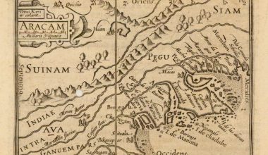
| 49 | Indiae Orientalis Nova Descriptio | Jansson, n.d. |
| 50 | Insularum Moluccarum Nova descriptio | Jansson, n.d. |
| 51 | China Veteribus Sinarum Regio nunc Incolis Tame dicta | Jansson, n.d. |
| 52 | Tartaria Sive Magni chami Imperium | (Jansson), s.l.n.d. |
| 53 | Africae nova Tabula | J. Hondius / Meufves / Boisseau, H. Picart sculpsit, n.d. |
| 54 | Guinea | Jansson, n.d. |
| 55 | Aethopia superior vel interior vulgo Abissinorum sive Presbiteri Ioannis Imperium | (Blaeu), s.l.n.d. |
| 56 | Aethiopia Inferior vel exterior | (Blaeu), s.l.n.d. |
| 57 | America noviter delineata | J. Hondius /(Meufves/Boisseau), H. Picart fecit, n.d. |
| 58 | Insulae Americanae in Oceano Septentrionali cum Terris adiacentibus | Jansson, n.d. |
| 59 | Nova Virginiae Tabula | H. Hondius, n.d. |
| 60 | Terra Firma et novum Regnum Granatense et popayan | Jansson, n.d. |
| 61 | Peru | J. Hondius (Jnr), n.d. |
| 62 | Paraguay Prov. de Rio de la Plata…TVCUMAN et Sta Cruz de la Sierra | Jansson, n.d. |
| 63 | Freti magellanici ac novi Freti vulgo Le Maire | (Blaeu/Jansson ?), s.l.n.d. |
| 64 | Accuratissima Brasilia Tabula | H. Hondius, n.d. |
Bibliography
Pastoureau, Mireille Les Atlas Francais XVI – XVII Siecles, (Paris: Bibliotheque Nationale, 1984).
Loeb-Larocque, Louis Theatrum Orbis Librorum – Liber Amicorum presented to Nico Israel, (Utrecht: HES, 1990)
Shirley, Rodney W. The Mapping of the World 1472 – 1700, (London: New Holland Publishers, 1993) and personal communication.