John Seller Sr. (d.1697) is one of the most important figures in the early history of the map and chart-publishing trade in England. He was the first Englishman to try establish an atlas-publishing business comparable with Continental firms, such as Blaeu, Jansson, de Wit, Goos, Colom & Doncker.
No other London publisher of his day offered the variety of stock that Seller sold. In folio form he published a celestial atlas, two terrestrial atlases, a sea-atlas, several coasting pilots, as well as a large number of separately-issued charts. In addition, he also published number of navigation handbooks, almanacs, pocket books, miniature sea-atlases, and made a variety of mathematical and navigational instruments and tools.
Unfortunately his efforts were built on shaky foundations and were ultimately unsuccessful. For much of his business life Seller walked a narrow line between solvency and bankruptcy. In 1677 bankruptcy was averted only by Seller entering into partnership with a consortium of interested parties, principally William Fisher, a leading printer and seller of navigation books, and John Thornton, a noted manuscript chartmaker who was beginning to make the successful transition into the printed chart trade.
While one explanation of this is Seller’s own lack of business acumen, his career also emphasises that the domestic market in Britain for printed maps and atlases was simply too small to absorb the output of an active and innovative publisher. Seller’s failed to marshal his limited resources and direct them into one project at a time. Instead he endeavoured to produce too many divers atlases and pilots at one time and did none of them particularly well
Seller paid a heavy price for the rescue by Thornton and Fisher. When the partnership was dissolved in 1679, Fisher retained the publishing rights for Seller’s two main sea-atlases, English Pilot for the Southern Navigation and the Atlas Maritimus, and also took several map-plates and some of the stock of printed sheets. Thornton received some of Seller’s stock of printing plates.
Seller made one last effort to restore his business, planning an ambitious county atlas from new surveys: this project also foundered, and thereafter he remained a small-time player, while his former partners expanded and prospered.
Seller’s principal folio atlas, and the one most frequently encountered today, was the Atlas Maritimus, first published in 1675. This sea-atlas was completely composite in make-up, being assembled according to the wish of the individual purchaser rather than to a standard format, although built round a standard core.
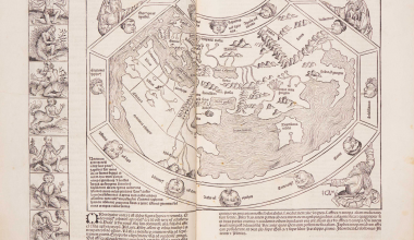
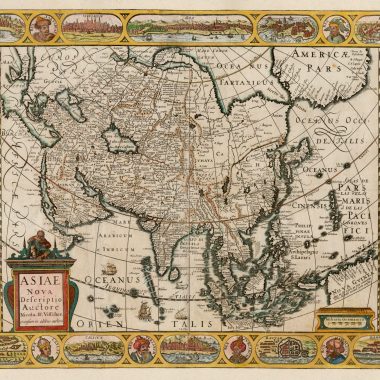
Accordingly, the content can vary considerably. The example being described is among the largest of such collections that I have seen, and is noteworthy for the way Seller had combined charts from the Atlas Maritimus of Frederick de Wit, published circa 1675, with his own, to make a total of forty-three charts.
Among the most interesting of the Seller charts are the group of astronomical charts and the map of the North Pole, which were prepared in 1676 or 1677, and so are found only in late examples of the atlas.
The example of the atlas described was dispersed in separate sheets, or lots, at two auctions in London. At the time an attempt was made to acquire all the Seller charts, to reconstitute the Seller element for a collector. Unfortunately, while all the charts from the first sale were purchased, three of the most valuable, all already present in the client’s collection, proved evasive. After the sale, the letterpress titlepage was purchased from the vendors, who retained the engraved title, although it was photographed at the time.
The atlas now forms part of the Lawrence Slaughter Collection, in the New York Public Library’s Map Division.
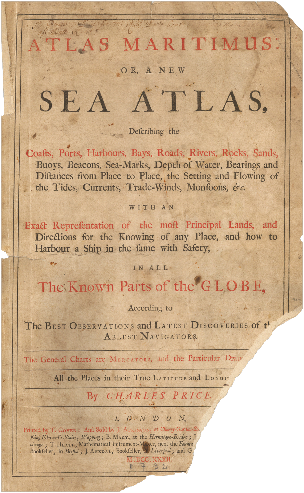
| A | Atlas Maritimus, / OR THE / SEA-ATLAS; / BEING / A Book of Maritime Charts. / DESCRIBING / The Sea-Coasts, Capes, Headlands, Sands, Shoals, Rocks / and Dangers. The Bays, Roads, Harbors, Rivers and / Ports, in most of the known Parts of the / WORLD. / COLLECTED / From the latest and best Discoveries that have been made: / by divers able and experienced Navigators of our / ENGLISH NATION. / Accomodated with a Hydrographical Description of the whole / World; Shewing the chief Cities, Towns, and Places of Trade and / Commerce; with the Nature of the Commodities and Merchandizes / of each Country; very useful for Merchants, and all other Persons / concerned in Maritime Affairs. / [rule] / By John Seller, Hydrographer to the King. / [rule] / [woodblock: Royal Arms] / [rule] / Cum Privilegio Regis. / [rule] / LONDON, Printed by John Darby, for the Author, and are to be sold at his Shop at the / Hermitage in Wapping, M. DC. LXXV. | ||
| B | ATLAS / MARITIMUS. / or A BOOK of / CHARTS. / Describeing the SEA Coasts Capes / Headlands Sands Shoals Rocks and Dangers. / the Bayes Roads Harbors Rivers and Ports. in / most of the knowne parts of the / WORLD. / With the true Courses and distances, from one / place to another, Gathered from the latest and / best Discoveryes, that have bin made by divers / Able and Experienced Navigators, of our English / Nation, Accomodated with an Hydrographicall / Description of the whole WORLD. / By John Seller. / Hidrographer to y.e Kings most Excellent Majestie / And are to be Sold by him, at the Hermitage Staires / in Wapping, and at his Shop in Exchange Alley. / Near the Royall Exchange. / in London. / Cum Privilegio. | B: 351 x 202 | |
| 1 | Frederick de WIT: World | ||
| 2 | [Untitled Chart Of The Northern Celestial Hemisphere, with general title] The Right Ascensions // and Declinations / of the Principal // Fixed Starrs in / both He= // misphears / to y.e year 1676. [2a & 4a] Clarissimo Amplissimoq Viro / Domino IONAE MOORE Equiti / Tormentorum Bellicorum, Armamentariorumq / Sacrae Regiae Ma.tatis Supervisori Generali; / Rerum Mathematicarum fautori summo: / hanc BOREALIS HEMISPHAERII tabulam / in perpetuam observantiae sitae tesseram / humillime D.D.D. Ioannes Seller. [4b] printed & sold by John Seller. [2e] [Tables] ‘A Table of 20 of the Principal starrs / in the first Quadrant of Right Ascension.’ [1a, ob] ‘A Table of 20 of the Principal starrs / in the second Quadrant of Right Ascension.’ [5a, ob] ‘A Table of 20 of the Principal starrs / in the third quadrant of Right Ascension.’ [5e, ob] ‘A Table of 20 of the Principal starrs / in the fourth quadrant of Right Ascension.’ [1e, ob] ‘Magnitudines Stellarum.’ [1b, ob] | B: 498 x 492 PM: 500 x 497 | |
| 3 | [Untitled Chart Of The Southern Celestial Hemisphere] Ia: Clark sculp: [1e] CAROLO II.o D.G. MAG. BRIT. FRA. & HIB. REGI SEMPER AUG / Hanc AUSTRALIS HEMISPHAERII Tabulam / nuperis observationibus jussu Regio susceptis, restitutam, / plurimisq stellis nondum Globo ascriptis, locupletatam, / submisse offert Subditus Humillimus / Edmon: Halleius. / e Coll. Reg. Oxon. [3b] [Diagrams] ‘Schema Solis ad ingressum Mercurij / S.tae Helenae, Anno 1677 Octob. 28 / 9.h 26′. 40″ AM.’ [1a, ob] / ‘Schema Solis ad exitum Mercurij. / S.tae Helenae. Anno 1677. Octob. 28 / 2.h 41′ 00.” P.M.’ [5a, ob] / Schema exhibens Triangulum Sphaericum, / in calculo Ascensionis Rectae et Declinationis, / e longitudine et latitudine datis, resolutum. [1e, ob] / ‘Schema exhibens Triangula Sphaerica, / in calculo loci Stellae incognitae, e di= / stantijs a duabus cognitis, resoluta.’ [5e, ob] / ‘Magnitudines Stellarum.’ | B: 499 x 492 PM: 503 x 499 | |
| 4 | ZODIACUS STELLATUS CUJUS LIMITIBUS PLANETARUM OMNIUM / VISIBILES VIAE COMPREHENDUNTUR. Autore Jo: Seller Serenissimi Reg: Hydrographo. [1a-5a] | Image: 451 x 588 B: 512 x 594 In 4 strips: 109 x 588 / 109 x 588 / 109 x 588 / 110 x 588 | |
| 5 | A mapp of the two / HEMISPHERES / of the Heavens / By John Seller his Ma.ties Hyd.r / And are to be sold at the / Hermitage in Wapping. [3b, ob] [Diagrams] ‘Phases Lunae / Crescentis et Decrescentis.’ [3d, ob] ‘Systema Saturni.’ [3d, ob] ‘The true Mag= / nitudes of the Planets.’ [1d, ob] ‘The Greatest Visible Magnitudes / of the Planets at the Earth.’ [5d, ob] [Notes] ‘To finde the Right Ascention of a Star. / …’ [1b, ob] ‘To finde the Declination of any Star. / …’ [1b, ob] Stars signs: top: ‘ARIES’ ‘TAURUS’ ‘GEMINI’ ‘CANCER’ ‘LEO’ ‘VIRGO’ [1a, ob – 5a, ob] bottom: ‘LIBRA’ ‘SCORPIO’ ‘SAGITTARIUS’ ‘CAPRICOR:’ ‘AQUARIUS’ ‘PISCES’ [1e, ob – 5e, ob] | 223 x 440 B: 295 x 440 PM: 299 x 442 | |
| 6 | A Mapp of the Regions & / Countreyes vnder / and a bout the / NORTH POLE / by Iohn Seller / Hydrographer to the King. [2b, ob] [Note] THE / Names of / those worthy persons / that haue Attempted y.e Discouery / of a North East Passage to / CHINA and IAPAN. / [rule] / M.r Rich: Chancellor first found out the / Passage by Sea .to Russia Anno 1550 / M.r Hugh Willoughby first Discouered / Green Land or King Iames his new land attempted / to finde the North east passage to / CHINA. Anno 1553 in his / Returne was frozen to death. / M.r Step: Burrough Attempted y.e like passage Anno 1556 / M.r Arthur Pet and M:r Charles Iackman, Anno 1580 / Passe:d the Straites of Vaigats and saild along the / Coast of NOVA ZEMLA as far as the Ise / Would giue him leaue, / M.r Ionas Poole and Tho: Edge made / a Voyage towards y.e Poole 1585; that / Ingenious and Industerous C: Iohn Wood / Attempted the like / Discouery / 1676. [2b] [Insets] [Landscape, with Polar Bears] [1a, ob] [Eastern Russia, Korea & Japan] [5a, ob] [Whaling] [1e, ob] [Landscape, with reindeers pulling a sleigh, & 2 Laplanders (?) with arrows] [5e, ob] | Image: 432 x 426B: 431 x 540 PM: 436 x 546 | |
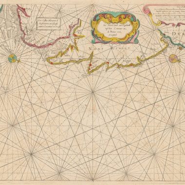
| 7 | A Chart of the Seacoasts / of / ENGLAND FLANDERS & HOLLAND / Shewing all the Sands Shoals Rocks and Dangers / The Bayes Roads Harbours Buoyes Beacons and / Seamarks on the said coasts. / By John Seller Hydrographer in Ordinary to the King / And are to be sold at his Shopps in Exchange Alley in Cornhill and at the / Hermitage in Wapping: London. [1b] Ja: Clark sculpsit. [4d] Ornat.mo Consult.moq Viro / D. JOS. WILLIAMSON / Equiti Aurato Jn Regni Comitijs / Senatori. / Regiae Majestati ab Archivis statüs, / Et Sanctiori Concilio a Secretis. Tabulam hanc qualem / L.M.D.C.Q. / Joh. Sellerus. [2c] [Royal Arms] [2d] | 432 x 532 PM: 439 x 539 | |
| 8 | Frederick de WIT: Great Britain | ||
| 9 | Frederick de WIT: Russia and Novaya Zemlaya | ||
| 10 | Frederick de WIT: Coast Of Norway | ||
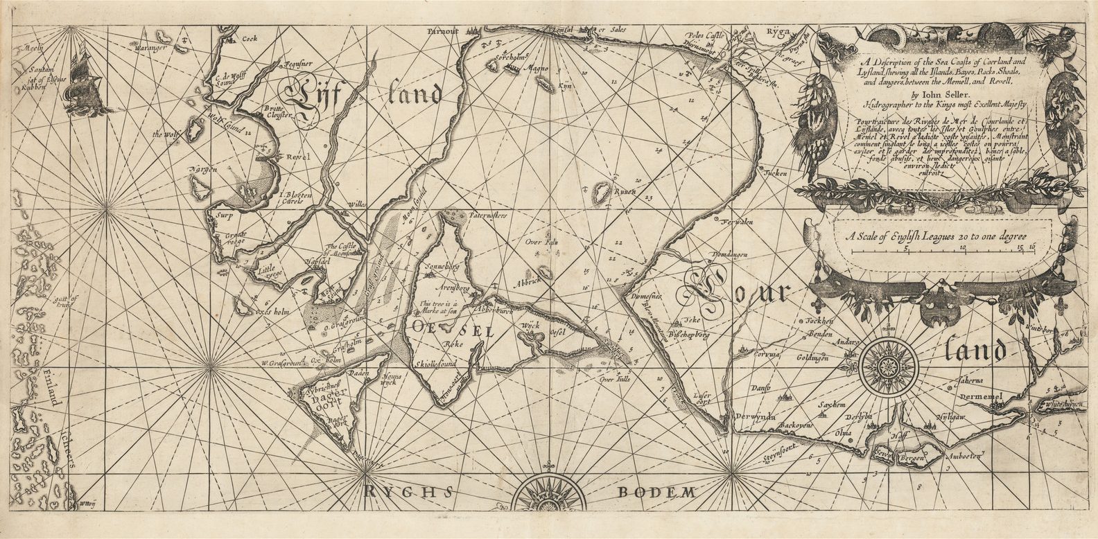
| 11 | A Chart of the Sea Coasts of / Russia Lapland Finmarke / Nova Zemla and Greenland / Described by Iohn Seller / Hydrographer / to the Kings most Excellent / Majesty. [5b] Steph Board sculp: [3e] | 438 x 540 PM: 440 x 545 | |
| 12 | Frederick de WIT: Baltic | ||
| 13 | Frederick de WIT: Denmark | ||
| 14 | A Chart of the / two / CHANNELS / goeing into the / BALTIQUE SEA / one / Through Catte Gat and the / SOUND / And the other Through the / BELT / By John Seller Hydrograph:er / to the King. [2b] Inset: [‘Coppenhaven’ and the islands of ‘Draker’ & ‘Southolm’] [2b] | 433 x 543 PM: 438 x 547 Inset: 97 x 103 | |
| 15 | A Large Description / of the two Chanells in the River / Dwina goeing up to the Citty of / ARCHANGEL / by John Seller. [1a] | 420 x 517 PM: 426 x 525 | |
| 16 | A Chart of the / BRITTISH= / CHANEL / By IOHN SELLER, Hy- / drographer to the Kings= / Most Excellent Majestie / LONDON. [3b | 429 x 536 PM: 433 x 543 State 2: the scale bars have been re-engraved | |
| 17 | Frederick de WIT: France | ||
| 18 | Frederick de WIT: Spain | ||
| 19 | The Royall City of / TANGIER in AFRICA. / By John Seller / Hydrographer to the King. [3a] Io. Oliver Fecit. [5d] [Key] [A-H, J-T, V-Z, 1-5] [5a-5b] Inset: [Tangier And Hinterland] [1a/b – 2a/b] | 394 x 519 PM: 405 x 529 Inset: (ib) 103 x 160 | |
| 20 | Frederick de WIT: Western Mediterranean | ||
| 21 | A MAPP CONTAINING THE ISLAND & KINGDOME OF SICILY, WITH A PART OF NAPLES, & OTHER AD- / IACENT COASTS INCLVDING THE TYRRHENEAN SEA WHERE MOST OF THINGS BETWIXT SPAINE & FRANCE & THEIR ALYES ARE ACTED, VERY COM[M]ODIOVSLY / Contrived for y.e present Juncture of affaires, & particularly the Citty & Fare of Messina, both Prospect and Groundplat etc. And are to be Sold by Iohn Seller Hydrographer in Ordinarie to the King. at his Shop at the Hermitage in Wapping. A.o 1676. [1a, ob – 5a, ob] W. Hollar fecit, 1676. [2e, in border] Inset: ‘Prospect of the Straights of Sicily Vulgarly calld / FARO DI MESSINA, / from the North.’ [2a – 4a] [2a/b – 5a/b] ‘MESSINA.’ [2d] [1d/e – 2d/e] [‘Faro / di / Messi- / -na’] 4c/e – 5c/5e] | M: 402 x 531 B: 426 x 531 PM: 440 x 544 Insets: A: 123 x 372 B: 123 x 195 C: 212 x 120 | |
| 22 | Frederick de WIT: Eastern Mediterranean | ||
| 23 | Frederick de WIT: chart of part of Africa | ||
| 24 | Frederick de WIT: chart of part of Africa | ||
| 25 | Frederick de WIT: chart of part of Africa | ||
| 26 | [Untitled Sheet of views of St. Helena / Cape Bona Esperanca / Ascension Island / Pike Mountain, Teneriffe] | B: 526 x 403 PM: 532 x 408 | |
| 27 | A New Mapp of the Island of / SAINT HELLENA / By John Seller / Hydrographer to the King. and are sold at his / Shop at the Hermitage stairs in Wapping. / The Body of this Island lyeth in 16 deg. South lat. [4b] Io. Oliver Fe. [2e] [Blank dedicatory cartouche & coat of arms] [2b] [Note] This Island was taken by the Dutch in the year 1672 / and in the beginning of the year 1673 it was in this manner / retaken by the prudent Conduct of that valiant Commander / S.r Richard Munden in his Majesties ship Assistance. [2e] | 429 x 533 | |
| 28 | A / Draught of Cape = / BONA ESPERANCA / By Iohn Seller / Hydrographer to the / King. [2b] Inset: [Prospect of Cape Town and Table Mountain] [1a/b-5a/b] 167 x 536 / [View of the Dutch Fort] [4a] 73 x 122 | 274 x 536 B: 443 x 536 PM: 455 x 546 | |
| 29 | A Chart of the / WESTERN / part of the / EAST INDIES. / With all the Aejacent Islands. / from Cape Bona Esperanca / to Cape Comorin / By Iohn Seller Hidrographer / to the KING and are to be Sold / at the Hermitage in Wapping. [2e] F. Lamb sculp. [1e] To the Honorable / the Governer, Deputy / and Committe, of the / EAST INDIA / COMPANY. / Iohn Seller. / Humbly Dedicates this Chart / of the East Indies. [1e] | 430 x 533 PM: 433 x 541 | |
| 30 | A Chart of the / EASTERMOST. / part of the. / EAST INDIES. / With all the Adjacent Islands / from Cape Comorin. to Iapan. / By Iohn Seller. Hydrographer / to the King. and are to be Sold at / the Hermitage in Wapping. [2c] F. Lamb Sculp. [4e] Nobilissimo Prudentissimoq Dom.no / Georgia Domino Berkley de / Berkley Castro, Chartam hanc / Maris Indin Orientalis Submisse / D.D. Iohannes Sellerus. [5e] | 434 x 542 | |
| 31 | A Chart of the / TARTARIAN / SEA / from NOVA ZEMLA to / IAPAN / By John Seller / Hydographer to the King / At the Hermitage Stairs in Wappi.n / & in Exchange Ally in Cornhill. / London. [1d] | 420 x 521 PM: 427 x 530 | |
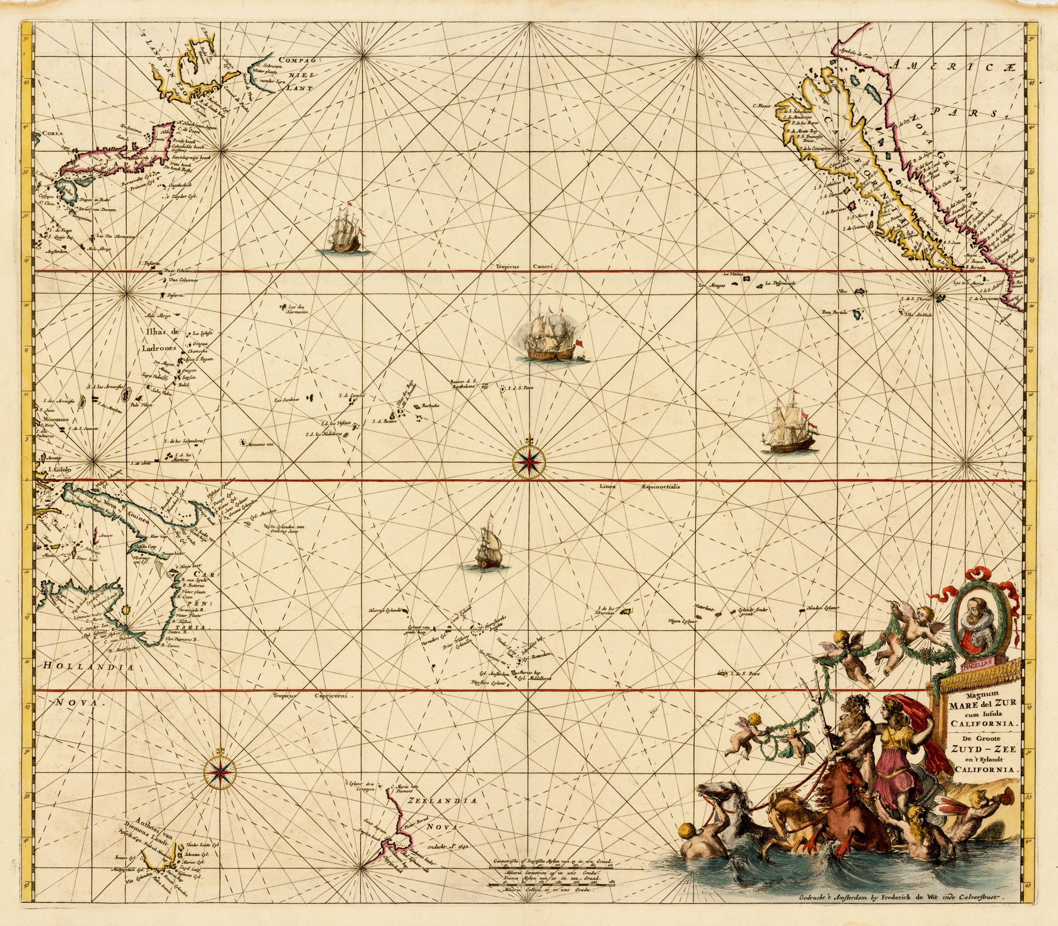
| 32 | Frederick de WIT: Western approaches to America | ||
| 33 | A / General Chart / of the / WEST INDIA’S / By John Seller / His Ma.ties Hydrographer. [5b] Inset: [South America below Rio de la Plata] [2d] | 424 x 526 PM: 427 x 528 Inset (ib, widest) 130 x 132 | |
| 34 | [not known] | ||
| 35 | Frederick de WIT: West Indies | ||
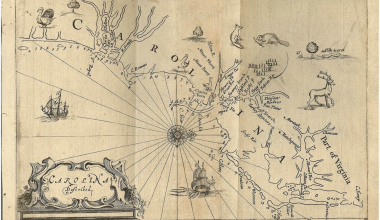
| 36 | A Chart / of the Sea coasts of / NEW=ENGLAND / NEW=JARSEY VIRGINIA / MARYLAND and CAROLINA / From C. Cod to C. Hatteras / By John Seller Hydrog.r / to the King. [2b] Iames Clerk sculpsit. [5e] [Blank dedicatory cartouche, surmounted by a blank shield] [5e] | 431 x 540 PM: 438 x 54 | |
| 37 | Novissima et Accuratissima / INSULÆ JAMAICÆ. / DESCRIPTIO / per / JOHANNEM SELLERUM. / Hydrographum Regium / Londini. [2d] Made and Sold by Iohn Seller at his shops: At the Hermitage in Wapping: And in Exchange=Alley near the Royal=Exchange in London. [2e – 4e, in border] [With Arms] ‘Leit: Gen: Doyley / first Governour / for his Majestie.’ ‘Tho: Lord of Winsor / Second Governour.’ ‘S.r Tho: Modiford / Bar: Fourt.h Governour.’ ‘S.r Thomas Lynch / Knight present / Governour.’ [2e] | 424 x 543 PM: 429 x 546 State 2: the 4 coats of arms have been inserted to the right of the title cartouche. The dedication cartouche is still blank. | |
| 38 | Frederick de WIT: Central America | ||
| 39 | Frederick de WIT: Brasil | ||
| 40 | A Chart of the Sea Coast of / BRAZIL. / From Cape S.t Augustine. to the / Straights of Magellan, & in the / South Sea, from the Lattitud of / Eight Degrees, to the said Straights / Made and sold by John Selle[r]. Hidrographer to / the King, at the Hermitage in Wapping. [5e] To that Valient and Worthy Com[m]ander, / Cap.t John Narborough, who Passed & Repas- / ed the Streights, of Magellan, in the Year 1670 / John Seller, in Testimony of the Respect he bears / to him Humbly dedicates this Chart. [2b] [Coat of arms blank] | 430 x 525 PM: 437 x 528 | |
| 41 | Frederick de WIT: Southern South America | ||
| 42 | A Chart of the / SOUTH=SEA / By John Seller / Hydrographer to the Kings most / Excellent Majestie. [5a] Dundee sculp= [1e] | 429 x 536 PM: – x 540 | |
| 43 | Frederick de WIT: Pacific |